#worldbuilding map
Text
A tutorial on a (bit cheating) way of creating fictional maps.
Open your editing software (RECOMMENDING Krita, since it's free and it's very good).
Step 1: Google "X country silhouette" and copy it.
Paste it onto the canvas.
Step 2:
Separate the silhouette from the background you copied with it! You can do that by using magic wand selection tool or by making a gradient map with black on 49,9% and transparent on 50% on the slider.


Step 3: Repeat several times with numerous countries and/or islands, cities, municipalities, communes, continents et cetera.
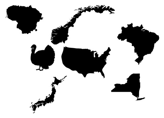
Step 4: Combine, mesh, stretch, rotate, mirror - go ham, make it work.
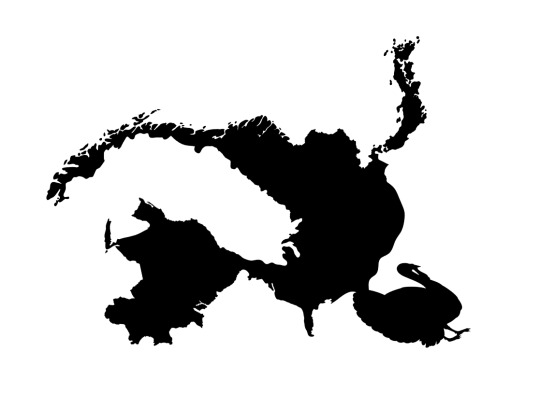
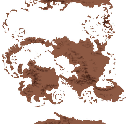
Step 5: Erase and add.
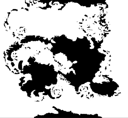
Step 6: Have your map outline ready, copy/paste it several times in the same doc on different layers and edit in different ways like biomes, kingdoms, mountains and other.
Step Mountains+: To figure out mountains, make another layer on the doc and do something like this:
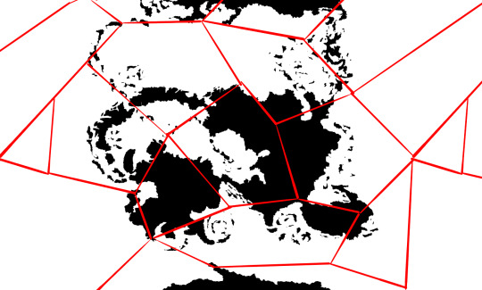
-and then in every polygon you add an arrow.
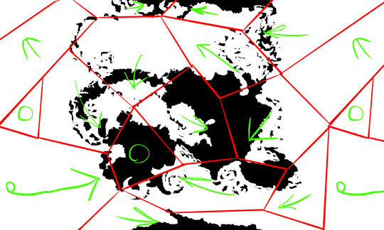
Where arrows meet or transfer onto continents, add mountains.
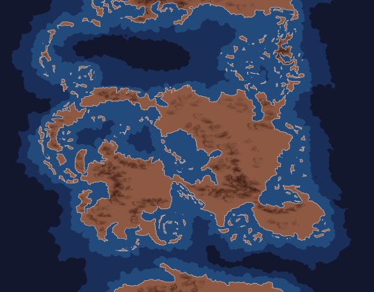
Color the sea with a couple layers of depth and you're done :D

#cartography#making maps#fantasy world#making fantasy maps#fantasy worldbuilding#worldbuilding map#map#maps
8K notes
·
View notes
Text
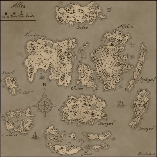
Hi there my fellow tumblrs, I want to start off & say thank you so much again for all the support & love lately, you have no idea how much I appreciate the interest in my work. 💛
As I said in my latest post here is the world map for Allra. It only took like 33 hours. ಠ_ಠ I’m hoping in the future to update it as I continue on my WIPS & to also make some in detail close ups of each continent & even towns & cities. Also a basic history & lore dump of Allra will be coming soon ! Thank you so much again, best wishes and love y’all 💛 (artwork is mine, do not steal or use without permission ty)
#Allra world map#Chronicles of Allra#writers on tumblr#writerscommunity#writing#fantasy#writblr#fantasy map#world map#worldbuilding#worldbuilding map
19 notes
·
View notes
Text

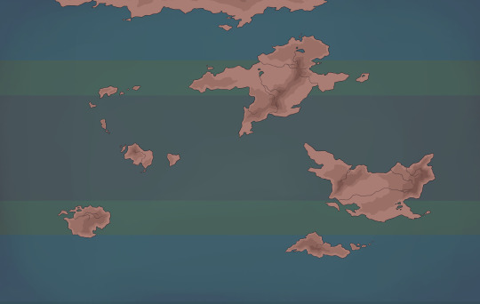
I've started mapping the cultures I've been developping onto the map. This is supposed to be a reference / guide and will be updated later as I work on the world.
#worldbuilding#fantasy worldbuilding#worldbuilding art#worldbuilding project#map#worldbuilding map#worldpond
10 notes
·
View notes
Text
14 notes
·
View notes
Text
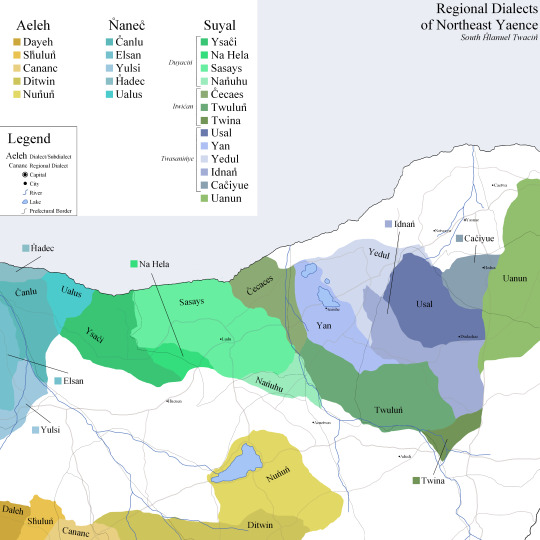

inspired by @reyneluvirith skyrim and fire emblem maps sent to me by my friend, maps depicting the sub and regional dialects of the northeast of the country Yaence.
Also featuring lakes and rivers too small to be included on my past world maps(but not the big interactive QGIS one ive been doing forever), major highway-type guys(though these are primarily used by forms of public transit), the borders of prefectures, and some major-ish cities in the area.
Some info about the cities pictured, and the dialect fuckery going on as well below the cut!
LANGUAGE AND DIALECT
Pictured in this map are two major languages that fall under the Tewenic language family, and are sister languages. Called Twac̊in̊(left) and Seșǔ(right), they linguistically are more akin to niece and aunt respectively, with the latter diverging from the Tewes protolanguage at the same time as the common ancestor of Twac̊in̊ and minority language Hetema. Due to this, the writing used by Seșǔ is closely related to that of Twac̊in̊ , but retains archaic artifacts of the abjad that was once used by Twac̊in̊ , and remains still in Hetema. Examples of these archaic letters include the use of the cluster t-w(fig. 1) instead of the single glyph tw(fig. 2), and the original m(fig. 3) glyph that fell out of use in Twac̊in̊ due to the sound being dropped altogether as a phoneme. Despite being the most widespread in the language family, Twac̊in̊ is the only member to have lost the /m/ sound.

The organization of the different subsections of language can get a little rough, especially since I've had this project since forever, but he's a basic chart to get you by:

Basically, language describes what I call all forms of the language, comparable to English as an entire language. Macrodialect refers to massive regions that all share similar overall differences. So English : American English = Twac̊in̊ : South H̊lanuel. From there, dialect or subdialect, used interchangeably, is across comparatively smaller areas, but still pretty big. Where macrodialects may cover an entire section of a continent, a dialect may only cover a country or two. Then down into regional dialects, which are within a country at their largest. Comparing to real life again, USA southern English : Atlanta area dialect = Suyal : Na Hel.
TWAC̊IN̊
The official language of the nation, and technically has a lot of overlap and overshadowing in the areas marked in the Seșǔ map, but that's not what I wanted to highlight with these maps. It is the language of majority across all three species that reside in the country: yotavuș, the native species, making up about 79% of the population of Yaence; humans, making up about 13%; and Keleŵu making up the rest. Yaence is a bit of an outlier in terms of human population outside of Earthspace :).
Featured in particular are the three of the four subdialects of macrodialect South H̊lanuel spoken in Yaence: Aeleh, Suyal, and N̊anec̊. Not pictured are Luatwed, found in the furthest western corner of the nation, and the In̊seh subdialects Lusus and Siyue to the south. The nation's most populated city, Ludu, as of the 2372 census, is often considered as the place with the "most correct" dialect in the country, and the word <Duyacin̊> implies a sense of being the everyman, "normal", and most importantly, Not Poor. One of my main characters born and mostly raised in the city actually has an accent in direct opposition to this, due to his parents raising him around people with accents from central parts of the country, areas considered to be less well-off.
SEȘǓ
Something extremely important, which you may have noticed in the maps themselves, is that the nation's capital is surrounded by one of the Seșǔ subdialects. More importantly, one of three subdialects that is native to Yaence, traditionally a non-Seșǔ country. This lends to a very... interesting accent in the people of Yasnae, which includes a muddling of the Twac̊in̊ /ʃ/, and the contrasting in Seșǔ of /ʃ/ and /s/ as the biggest offender noticed by other people in the country. Plenty of folks, in particular those in the western, less diverse regions of Yaence, look down on this accent as a degradation of the Twac̊in̊ language, and some extremist groups have put this fact forth as definitive proof that somewhere with an accent that better represents the majority of people(a touchy subject to the other people in the south and central regions that the westerners also look down on), namely, somewhere like Ludu or Nen̊in̊(not pictured).
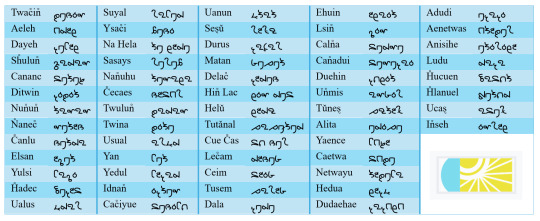
EXTRA
See below for a chart with these places and language parts written in the native writing system. Also, keep in mind that while Twac̊in̊ and Seșǔ use the same base alphabet, there are diacritics and the aforementioned archaic letters in play. Think of it like how both English and Spanish use the Latin alphabet, but similar letters may represent different sounds, and some variations may exist in one language but not the other(ñ and rr in Spanish, /ʒ/ for the most part in English). If anyone has specific questions about the language-y side of stuff, feel free to DM or send an ask!
#worldbuilding#my post#that there art#map#worldbuilding map#linguistics#conlang#conlanging#twacin#sesu#HEHEHEHEHE#gets silly with it#even tho i bajoran and bhevown post a lot#twacin has my fav ocs in there#including The Polycule#and the mycomorph with his bf
2 notes
·
View notes
Photo
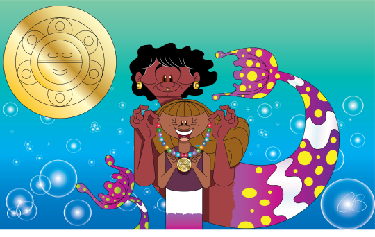
[Image description. A merman giving his mermaid daughter a necklace with rainbow beads and gold pendant with the Taino sun symbol. End description.]
Next Mermay piece! Now also for #mermayacrosstheseas . Which may be my favorite Mermay prompt simply because it's weekly. And it ties in perfectly with my Emily Windsnap fanart, plus the movie version’s worldbuilding map (click here to see it). Week 1's prompt is The Caribbean Sea, so here's Emily and Jake at their new home in the Bermuda Triangle ...
Given Jake's convenient knowledge about their secret Caribbean island, plus his black hair and brown eyes... I headcanon him being actually from the Caribbean. Some fans also suggested them being Taino (the left image is the Taino Sun symbol). Others suggested Allpoints (the Windsnap’s Caribbean home) having a Mayan look like Talokan in Wakanda Forever. Or they could be Haitian, like a certain character in the mid-credits. Also based on this sketch (click here to see it).
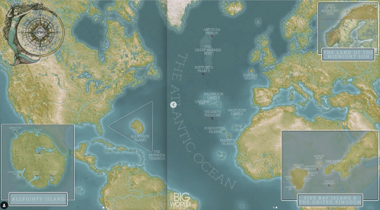
[Image description. Emily Windsnap movie worldbuilding map including the Caribbean. End description.]
#my artwork#mermay#mermay challenge#mermay 2023#mermay2023#mermaid#merman#caribbean#taino#emily windsnap#emily windsnap fanart#book#book fanart#emily windsnap movie#middle grade fiction#middle grade series#middle grade books#caribbean sea#worldbuilding map#liz kessler#mermay across the seas#mermayacrosstheseas
14 notes
·
View notes
Text
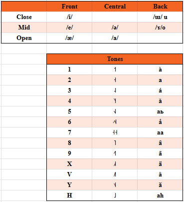
THE VOWEL WAR Ep.5
introducing Edȁrĭ... with 91 vowels
Your turn @ageblue
btw i feel like i need to elaborate on this. this was not made ad hoc for this war, i genuinely evolved Edȁrĭ as an alien language spoken by humanoid aliens (Nyadicha)...


...on planet Ùkrq́i (EXTREMELY unfinished project)

#conlangcrab#conlanging#conlang#conlangcrab talks#linguistics#worldbuilding#worldbuilding map#the vowel war
5 notes
·
View notes
Text
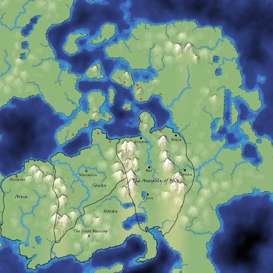
Lord of the Black Mountain: Map
I made a very rough map using mapgen4 to rough out where countries/capitols are in Lord of the Black Mountain. I haven't gotten around to making roads or anything, but I did put in locations of colonies/outposts of the Andals--those are the red xes. (Who are sea nomads engaging in some invasion/raiding/trading activities along the Sewen and Assembly of Five coastlines.)
Mapgen4 lets you do climate and water/land stuff but does not have forests. Pls assume that there are extensive forests in those mountains.
7 notes
·
View notes

Note
Hi! Hope I'm using this right, haven't really used this lol. Question: can you tell us about ways your world's geography has shaped it's people and politics?
M: Oh, that's a fun one to answer!
M: First, my home, the United Islands.

M: The peninsula is protected by a mountain range and a desert and the waters are hostile to those not skilled with ships.
This meant the nine islands and the peninsula were left to grow relatively undisturbed, except by each other, to which there was a lot of cultural mixing and trade.
So, my homeland is essentially 10 former kingdoms united under one banner.
We're an agriculture and trade power, with a specialty in goods like wine, oil, wool, and especially salt. With some of the best sailors in the world.
M: Next, the Jungle of Flowers to the northwest.

M: They're culture developed in a lush jungle clinging to the coast, backed by a mighty inland sea.
From my understanding, certain common infections cause low birth rate, which allowed women to claim power as the ones who can give birth, thus forming a matriarchal monarchy.
Their tropical climate makes them our main source of rare fruits and woods, as well as leather and furs. They also conflict a lot with smaller kingdoms and tribes to the west for access to the coast and ports.
M: The Twin Kingdoms are also interesting.

M: They're mostly isolated to the far northwest, on a frigid island with very few large land predators. The narrow stretch of land used to mark the border between two kingdoms, the Highlands and the Lowlands. They united under one king in the last 200 years or so to be more assertive in global trade, but the tension between the two groups were… palpable when I was there.
They're predominantly herdsman and fishermen, and they mostly serve as a stop between the Jungle of Flowers and the north east
M: The Golden River is actually where my husband's family is from.

M: They live in the desert, who built their living around the mouth of what I believe the largest river in the world. They're actually a lot of smaller kingdoms who all answer to a single religious leader, who's temple sits at the mouth of the river spilling out in the ocean.
They don't actually take money like most other places I've visted, being mostly trade based, and water being the signifier of wealth. However, they sit on a seemingly endless network of gold mines that they happily trade the rest of the world for, along with beautiful glassworks.
All of the kingdoms are in conflict with each other to some degree, all trying to get more sway over water sources and to become the next leader.
M: The Volcanic Steppe was one of the strangest places I visited.

M: They're lands consist of two islands, the western one consisting of very fertile farming land, a mountain range, and a massive volcano. The eastern island has two more groups, the nomadic herders of the steppe, and the mercantile bullwork on the southern coast. The three groups seem to be in a sort of symbiotic relationship to each other, although none seem to trust the other too much.
They don't have much in terms of a centralized government, with the two sedentary societies communicating with each other mutually, and the steppe people electing a kind of king among all of the nomadic tribes' chiefs. This king communicates with the other two societies.
They seem mostly interested in selling their magnificent horses, along with animal fats, leather, and volcanic glass.
M: The Silken Delta was the last place I lived in long term before coming home.

M: They live on a smaller peninsula, consistently rich with fertile soil from the many rivers and deltas flooding and receding every year.
They're a confederation of states, separated by rivers, with each state sending a representative to their central council at the tip of the peninsula.
They actually recently finished, and won, a major war with a mountain kingdom to the north, and they're enjoying the spoils. They're hungry to get back in the market, as I think they see the United Islands and economic rivals. Their cloth is something to die for, as are their spices and herbs.
M: I can go into much more detail on any of these lands if you have any follow up questions, but that's the overview.
#ask blog#send me asks#worldbuilding#ask box open#fantasy worldbuilding#digital art#my art#worldbuilding ask blog#ask answered#worldbuilding map#fantasy maps
3 notes
·
View notes
Text
Some people have asked me if I can publish my mapmaking tools. So I developed a software. 🙂
Here is the result:
#tabletop#dnd#battlemap#dnd maps#rpg map#dungeons and dungeons#dungeonmaster#dungeonsanddragons#fantasymap#worldbuilding#gamedev#indiegame#drawing#gaming
25K notes
·
View notes
Text
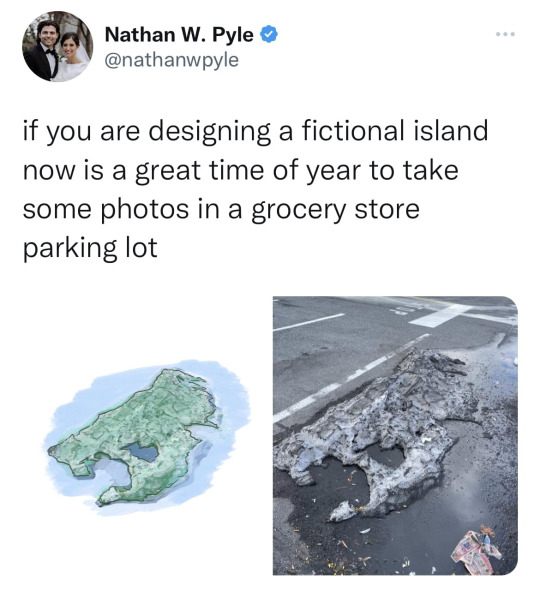
This came across my Facebook feed, felt I’d share it.
48K notes
·
View notes
Text
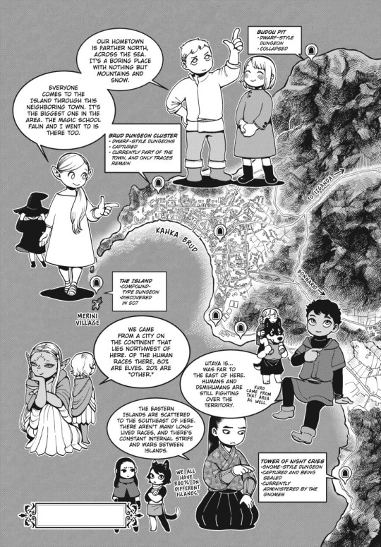
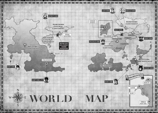
Dungeon Meshi - Kahka Brud and The Island
Kahka Brud - Town adventurer's go through to arrive at The Island, where the dungeon was discovered.
The Island - Island situated off the coast of Kahka Brud, The Dungeon was discovered conected to the village's graveyard.
Merini (Or Melini) - The Village where the Adventurer's stay and make preparations before adventuring in The Dungeon.
Image Texts under the cut
First Image Showing Kahka Brud
Laios pointing up: Our hometown is farther north across the sea. It's a boring place with nothing but mountains and snow.
Marcille pointing to Kahka Brud: Everyone comes to the island through this neighboring town. It's the biggest one in the area. The Magic School Falin and I went to is there too.
Cythis pointing west talking about the canaries: We came from a city on the continent that lies northwest of here. Of the human races there 80% are elves. 20% are "other."
Kabru pointing east (tiny Kuro with Mickbell on his shoulders besides him): Utaya is… was far to the east of here. Humans and Demihumans are still fighting over the territory. Kuro came from that area as well.
Shuro point downwards east: The Eastern Islands are scattered to the southeast of here. There aren't many longlived races, and there's constant internal strife and wars between islands.
Tiny Izutsumi and Rin: We all have roots on different islands.
Dungeons:
Budou Pit
Dwarf-Style Dungeon
Collapsed
Brud Dungeon Cluster
Dwarf-Style Dungeons
Captured
Currently part of the town, and only traces remain
Tower of Night Cries
Gnome-Style Dungeon
Captured and being sealed
Currently administered by the Gnomes
The Island
Compound-type Dungeon
Discovered in 507
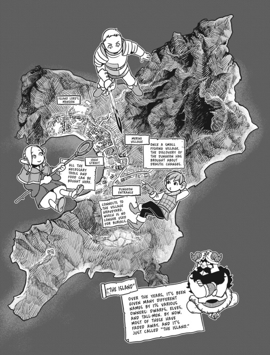
Second Image showing details of The Island
"The Island"
Over the years, it's been given many different names by it's various owners: Dwarfs, Elves, and tall-men. By now, most of these have faded away and it's just called "The Island."
Merini Village
Once a small fishing village, the discovery of The Dungeon has brought about drastic changes
[On the north-most part of the village]
Island Lord's Mansion
[Middle of the village, near the shore]
High Street
All the necessary tools and food can be bought here.
[Deeper to the southeast of The Island]
Dungeon Entrance
Connects to the Village graveyard, which is no longer used for burials.
[End of Descriptions]
Here's the world map in case you want to check it along with the descriptions from the characters, I'll make a dedicated post for it later on.
#dungeon meshi#worldbuilding#maps#The Island#dungeon meshi map#Dungeon Meshi Spoilers#the canaries#Laios Party#shuros party#Laios Touden#Falin Touden#Marcille Donato#Senshi#Senshi of Izganda#Kabru#Kabru of Utaya#Shuro#toshiro nakamoto#Kuro#Kuro Dungeon Meshi
826 notes
·
View notes
Text
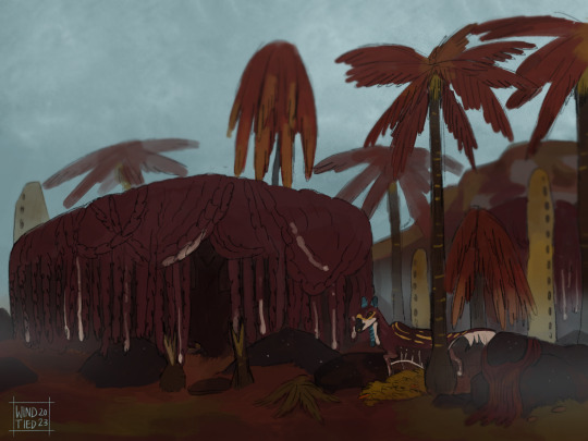


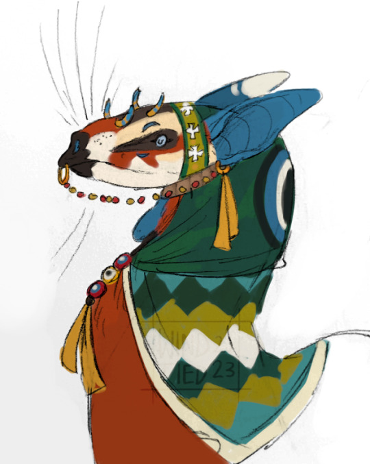
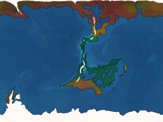

recent drawings I’ve made for a alien worldbuilding idea!
Kuvontir are a sophont alien species on a planet they call Vehnen. The largest species (central straight) average a size of 86 cm. The others are all somewhat shorter than them. They are primarily dependent on obtaining food from water sources, as they are mostly piscivores. The two central populations have used their ‘wings’ to glide above water and catch food.
While the north and south populations have lost that ability. Northern Kuvontir have become built to run from predators. While the southern population has used their ‘wings’ to help them dive under water.
#vehnen#my art#worldbuilding#original species#speculative biology#spec bio#speculative zoology#speculative evolution#alien species#spec evo#alien#maps
706 notes
·
View notes
Text

I'm obsessed with Flat Earth conspiracy maps so I made my own, I hope it catches on 😇
1K notes
·
View notes
Text
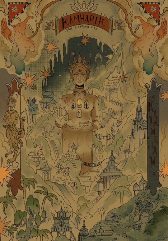
The city at the north of the moon
3K notes
·
View notes
Last Seen Blogs

ladyvogueuk
Lady Vogue UK

kleinuuu
Day Dreamer

whyyouresoseriousss
Why so serious?...

5erg6o-blog
Sin títulohttps://www.google.com/url?sa=t&source=w
badlydrawvnlittlecronus
hes badly drawvn