#tropical weather
Text
Atlantic Tropical Weather Outlook issued by the National Hurricane Center in Miami, FL, USA
2024-04-24, 20:00 EDT

For the North Atlantic...Caribbean Sea and the Gulf of Mexico:
East-Central Subtropical Atlantic: An area of low pressure located about 900 miles northwest of the Cabo Verde Islands has been producing a small but persistent area of showers and thunderstorms to the east of its center since this morning. However, the low is forecast to move southwestward at 10 to 15 mph into an area of stronger upper-level winds tonight and tomorrow, and additional development is not expected.
No additional Special Tropical Weather Outlooks are scheduled for this system unless conditions warrant. Regularly scheduled Tropical Weather Outlooks will resume on May 15, 2024, and Special Tropical Weather Outlooks will be issued as necessary during the remainder of the off-season.
* Formation chance through 48 hours...low...10 percent.
* Formation chance through 7 days...low...10 percent.
$$ Forecaster Berg/Brown
#sorry the beginning of the text was cut off at first! fixed now#the NHC changes the advisory formatting every year ever so slightly so i have to adjust how the bot parses them the first few posts lol#not gonna bother fixing the text timestamp since they sorta just post the special advisories whenever#bot tags:#bot post#meteorology#weather#tropical weather#tropical storm#tropical depression#hurricane#atlantic#atlantic ocean#caribbean#gulf of mexico#noaa#national oceanic and atmospheric administration#nhc#national hurricane center
15 notes
·
View notes
Text

Cairns, Australia
16 notes
·
View notes
Text

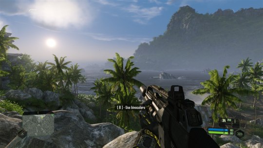
October 15, 2021
Crysis Remastered (2021)
#crysis remastered trilogy#vg#vgs#screenshot#my screens#crysis#crytek#pc gaming#video games#gaming#video game photography#tropical#beaches#water#graphics#tropical weather#tropical aesthetic#tropical island#island#pacific#aesthetic
3 notes
·
View notes
Text
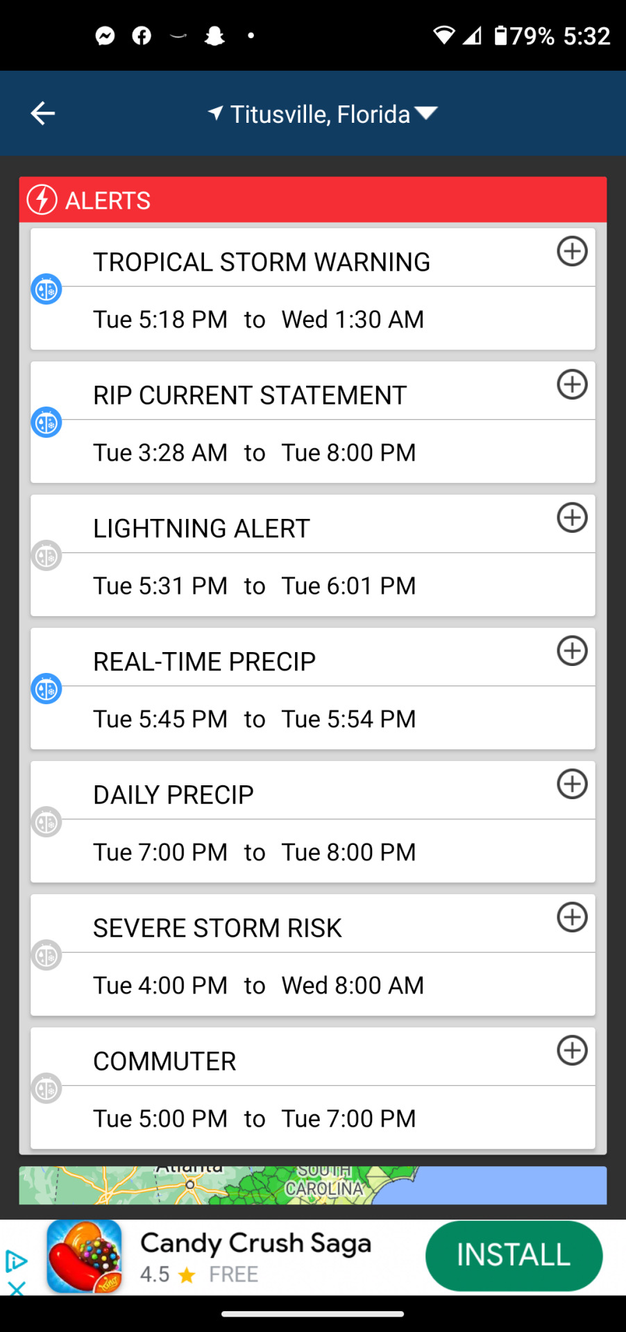
Summers in Florida during Hurricane Season
#hurricane idalia#hurricane season 2023#titusville#spacecoast#florida#brevardcounty#centralflorida#storms#tropical storms#tropical weather#idalia
3 notes
·
View notes
Text

House mouse (Mus musculus)
#Look how cute he is!!!#My photo#Mus musculus#House mouse#Rodentia#Muridae#Nature#Naturaleza#Natureza#Brazil#South America#Latin America#Cute#Mouse#Ratón#Camundongo#Hiiri#Ymparistö#Tropical weather
5 notes
·
View notes
Text
Tropical Storm Franklin his Dominican Republic

View On WordPress
#disaster#Dominican Republic#haiti#Hispaniola#hurricane#hurricane season#meme#memes#news#tropical storm#tropical storm Franklin#tropical weather#weather natural disaster
2 notes
·
View notes
Text

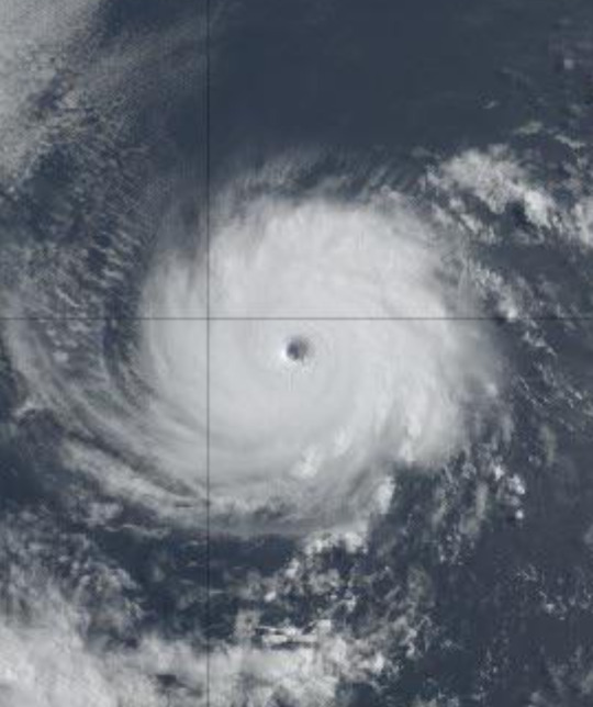

Redditors on the r/tropicalweather subreddit enjoying this particularly aesthetically pleasing, non-dangerous hurricane
4 notes
·
View notes
Text
haiku 20240307
old family photosoutside thunder and lightninglightning and thunder

View On WordPress
1 note
·
View note
Text

New Year, New Blog
Good evening, I wanted to start off the new year by saying welcome to my new site where I will be providing detailed weather discussions, storm chase blogs and even weather photography, similar to the one you see above. There is one disclaimer, the name of the blog site could change. It is something I am still figuring out and could change in the coming weeks. Please be patient on the name changes if they occur.
The goal of the site is to share my knowledge, passion, and most importantly respect for Mother Nature with everyone. My other goal is that I hope everyone will enjoy the content posted on here.
For the weather discussions, it will mainly be focus across West Tennessee, North Mississippi, and East Arkansas. This area will also be known as the Mid-South and will be constantly referred to that during my weather discussions and/or storm chase blogs.
While this will be my main area of focus, there will be times where I will discuss other extreme weather events that maybe ongoing somewhere else across the United States.
Since there will be times when I am storm chasing, I do not encourage storm chasing, unless you have the experience, knowledge and storm chase partner to go with. Storm chasing is very dangerous for a variety of reasons.
As for the photos you will see, those are taken by me and CAN NOT BE used without my permission at all. A lot of my photos will be watermarked with my name or will have a caption with with my name on it at all times. I will never use someone else's photo within the contents of my blog.
01/03/2023 5:30 PM CST
1 note
·
View note
Text

Are the Florida Keys Warm in Winter?
The Florida Keys, with their tropical climate, are known for providing warm and pleasant weather throughout much of the year. Winter in the Keys is a particularly attractive season for visitors seeking a respite from colder temperatures elsewhere.
During the winter months, which span from December to February, the Florida Keys experience mild and enjoyable temperatures. Daytime highs typically range from the mid-70s to low 80s Fahrenheit (24-29°C), creating an inviting environment for outdoor activities. The nights are cooler but still relatively mild, with temperatures rarely dropping below the mid-60s Fahrenheit (18°C).
One of the main reasons for the warm winter climate in the Keys is their geographical location. Situated at the southernmost tip of Florida, the islands benefit from the moderating influence of the surrounding warm waters of the Gulf of Mexico and the Atlantic Ocean. This maritime influence helps to keep temperatures relatively stable and prevents extreme fluctuations.
Visitors to the Florida Keys during the winter can enjoy a variety of outdoor activities, including snorkeling, diving, fishing, and exploring the unique ecosystems of the islands. The pleasant weather makes it an ideal time to experience the vibrant marine life, coral reefs, and natural beauty that the Keys are renowned for.
It's worth noting that while winter is generally warm in the Keys, occasional cold fronts can bring cooler temperatures for short periods. However, these events are typically brief, and the overall winter climate remains comfortable for those seeking a warm escape.
In conclusion, the Florida Keys offer a warm and inviting escape during the winter months, making them a popular destination for travelers looking to enjoy the beauty of the tropics without the chill of colder climates.
#Florida#Florida Keys#Winter Climate#Tropical Weather#Warm Temperatures#December#Gulf of Mexico#Atlantic Ocean#Maritime Climate#Snorkeling#Diving#Fishing#lifestyle#travel#journey#traveling#outdoors#aesthetics#mood#places#amazing#beautiful
0 notes
Text
Near the ITCZ
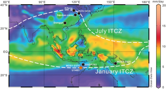
* This blog post was originally written on deviantArt in 2008, but was transferred to tumblr in 2023— and the picture above was added then. The picture is from a journal from The Journal of Geophysical Research Atmospheres, which was written in July 2020 and properly cited below:
Zhang, Peng & Xu, Jian & Holbourn, Ann & Kuhnt, Wolfgang & Beil, Sebastian & Li, Tiegang & Xiong, Zhifang & Dang, Haowen & Yan, Hong & Pei, Renjie & Ran, Yazhou & Wu, Hanning. (2020). Indo‐Pacific Hydroclimate in Response to Changes of the Intertropical Convergence Zone: Discrepancy on Precession and Obliquity Bands Over the Last 410 kyr. Journal of Geophysical Research Atmospheres. 10.1029/2019JD032125.
Whoohooo!
It's been a while, and as you know, I've started a new chapter of my life near the Intertropical Convergence Zone.
For those of you who don't know what that is, LOOK IT UP. You'll learn something new — here, as defined by the National Oceanic and Atmospheric Administration.
ANYWAY. to SUM IT UP.
It means i am experiencing some heavy downpour at the moment.
[wow. did that sound like something directly from a weather forcast of what?]
ANYHOW… though you might see it as unfortunate and SUCKS-TO-BE-YOU-THAT'S-WHAT-YOU-GET-FOR-LEAVING-THE-CALI-SUN…
I am honestly… happy.. to be experiencing this right now.
Why? Several reasons.
I have FORGOTTEN how GREAT it feels to feel the cold breeze brought on by the heavy rain come into the closed screen doors and window cracks.
It's been SOOOOOOOOOOOO LOOOOOOOOONG that I FORGOT that one's daily experience with the rain include hearing those bullets hit the roof continuously for hours and hours on end as if your house was being hit by a gazillion meteors.
I suddenly remember how much having the trees swaying the way it is in the CNN news when there's a hurricane is not really scary.. since you see it everyday.. just by looking outside the window. It's really does make me wonder why I would get a bit worried seeing those when I was still up there.. especially since I did grow up HERE >_>
I've forgotten how fascinating it is to look at the rain downpouring in a diagonal, sometimes curvy and swaying direction.. depending on the wind. It's really nice, especially at night when you look at the rain falling by the street lights.
Even though they gave me nightmares and a bunch of scary moments when I was a little child, I never would have thought I'd miss the sharp lightning that lit up the sky and it's accompanying thunder that shake the earth..almost a little too literally…
Reason #6? The most logical reason. It is waaaay better than the usual humidity. ^_^ soooo much better.
I missed feeling so… NATURAL about the entirety of the rainy season. It is a wonderful feeling. You feel like not doing anything else but sleep all daaaaaaaaaaaay.
..anyhow. it's the first time i've lived IN the city. and.. i think i'm getting used to it.
Typical Asia, i'm still working on getting used to the streets and roads.. but..i'll live.
what i can't wait to do is to go home to the province though.
anyhow.
i'm actually sleeping NORMALLY. for once. ^_^
it seems all along, i've been sleeping in the -8:00GMT time zone. hahaha
anyhow, i'll bring you guys some updates on my rants soon.
since i know this IS a PRETTY LONG rant..hahaha
c ya!
#life#life update#tropical weather#monsoon season#rainy season#Philippines#Asia#Southeast Asia#southeastasia#blogging#deviantart
0 notes
Text
Atlantic Tropical Weather Outlook issued by the National Hurricane Center in Miami, FL, USA
2023-09-03, 02:00 EDT
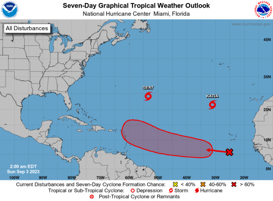
Active Systems: The National Hurricane Center is issuing advisories on Tropical Storm Gert, located about 700 miles east-southeast of Bermuda, and Tropical Storm Katia, located about 850 miles north-northwest of the Cabo Verde Islands. Eastern and Central Tropical Atlantic (AL95): A tropical wave located over the far eastern tropical Atlantic is producing disorganized shower and thunderstorm activity to the south-southwest of the Cabo Verde Islands. Environmental conditions appear conducive for some gradual development of this system by the middle part of this week, and a tropical depression is likely to form while it moves westward to west-northwestward at 15 to 20 mph over the eastern and central portions of the tropical Atlantic.
* Formation chance through 48 hours...low...30 percent.
* Formation chance through 7 days...high...70 percent.
$$ Forecaster Pasch
#bot post#meteorology#weather#tropical weather#tropical storm#tropical depression#hurricane#atlantic#atlantic ocean#caribbean#gulf of mexico#noaa#national oceanic and atmospheric administration#nhc#national hurricane center
44 notes
·
View notes
Text

At 1100 PM EDT (0300 UTC), the center of Tropical Depression Twenty-One was moving toward the northwest near 5 mph (7 km/h) and this motion is expected to continue tonight. On the forecast track, the depression will move inland over the next few hours over eastern Nicaragua.
Maximum sustained winds are near 30 mph (45 km/h) with higher gusts.
Little change in strength is forecast. The depression is forecast to dissipate inland over Nicaragua tomorrow.
0 notes
Text
Hurricane Season 2022
The Atlantic hurricane season of 2022 is over
Hurricanes in the Atlantic
The Atlantic hurricane season officially ends on November 30th. As a result, the 2022 season concluded today. This does not rule out the possibility of a tropical system forming outside of season, so any atmospheric disturbances must be continuously monitored.
The Atlantic hurricane season begins on June 1st and lasts…

View On WordPress
1 note
·
View note

Text
Atlantic Tropical Weather Outlook issued by the National Hurricane Center in Miami, FL, USA
2023-09-28, 14:00 EDT

Active Systems: The National Hurricane Center is issuing advisories on Tropical Storm Philippe, located several hundred miles east of the northern Leeward Islands, and on newly formed Tropical Storm Rina located over the tropical central Atlantic.
&& Public Advisories on Tropical Storm Rina are issued under WMO header WTNT33 KNHC and under AWIPS header MIATCPAT3. Forecast/Advisories on Tropical Storm Rina are issued under WMO header WTNT23 KNHC and under AWIPS header MIATCMAT3.
$$ Forecaster Cangialosi
#bot post#meteorology#weather#tropical weather#tropical storm#tropical depression#hurricane#atlantic#atlantic ocean#caribbean#gulf of mexico#noaa#national oceanic and atmospheric administration#nhc#national hurricane center
14 notes
·
View notes
Last Seen Blogs

iwpykkl56
iwpykkl56

dogecreations
Doge Creations

mybestneurologist
Untitled

nettyke9-blog
Netty-Art

violins-beat-violas
Veeb Things