#national hurricane center
Text

Looking into the powerful eye of a hurricane! Beautiful but terrifying
#astronomy#nasa#astronomers#universe#astrophotography#nasa photos#nasawebb#astrophysics#outer space#hubble space telescope#national hurricane center#weather#space exploration#space station#space shuttle#spacecraft#space#james webb space telescope#space photography#space science#planetary science#science#beautiful earth#planet earth#planetary nebula#earth#astronauts#astro community#astro notes#astro observations
510 notes
·
View notes
Text
Atlantic Tropical Weather Outlook issued by the National Hurricane Center in Miami, FL, USA
2024-04-24, 20:00 EDT

For the North Atlantic...Caribbean Sea and the Gulf of Mexico:
East-Central Subtropical Atlantic: An area of low pressure located about 900 miles northwest of the Cabo Verde Islands has been producing a small but persistent area of showers and thunderstorms to the east of its center since this morning. However, the low is forecast to move southwestward at 10 to 15 mph into an area of stronger upper-level winds tonight and tomorrow, and additional development is not expected.
No additional Special Tropical Weather Outlooks are scheduled for this system unless conditions warrant. Regularly scheduled Tropical Weather Outlooks will resume on May 15, 2024, and Special Tropical Weather Outlooks will be issued as necessary during the remainder of the off-season.
* Formation chance through 48 hours...low...10 percent.
* Formation chance through 7 days...low...10 percent.
$$ Forecaster Berg/Brown
#sorry the beginning of the text was cut off at first! fixed now#the NHC changes the advisory formatting every year ever so slightly so i have to adjust how the bot parses them the first few posts lol#not gonna bother fixing the text timestamp since they sorta just post the special advisories whenever#bot tags:#bot post#meteorology#weather#tropical weather#tropical storm#tropical depression#hurricane#atlantic#atlantic ocean#caribbean#gulf of mexico#noaa#national oceanic and atmospheric administration#nhc#national hurricane center
15 notes
·
View notes
Text
Climate experts fear Donald Trump will follow a blueprint created by his allies to gut the National Oceanic and Atmospheric Administration (NOAA), disbanding its work on climate science and tailoring its operations to business interests.
Joe Biden’s presidency has increased the profile of the science-based federal agency but its future has been put in doubt if Trump wins a second term and at a time when climate impacts continue to worsen.
The plan to “break up NOAA” is laid out in the Project 2025 document written by more than 350 rightwingers and helmed by the Heritage Foundation. Called the Mandate for Leadership: The Conservative Promise, it is meant to guide the first 180 days of presidency for an incoming Republican president.
The document bears the fingerprints of Trump allies, including Johnny McEntee, who was one of Trump’s closest aides and is a senior adviser to Project 2025. “The National Oceanographic [sic] and Atmospheric Administration (NOAA) should be dismantled and many of its functions eliminated, sent to other agencies, privatized, or placed under the control of states and territories,” the proposal says.
That’s a sign that the far right has “no interest in climate truth”, said Chris Gloninger, who last year left his job as a meteorologist in Iowa after receiving death threats over his spotlighting of global warming.
The guidebook chapter detailing the strategy, which was recently spotlighted by E&E News, describes NOAA as a “colossal operation that has become one of the main drivers of the climate change alarm industry and, as such, is harmful to future US prosperity”. It was written by Thomas Gilman, a former Chrysler executive who during Trump’s presidency was chief financial officer for NOAA’S parent body, the Commerce Department.
Gilman writes that one of NOAA’S six main offices, the Office of Oceanic and Atmospheric Research, should be “disbanded” because it issues “theoretical” science and is “the source of much of Noaa’s climate alarmism”. Though he admits it serves “important public safety and business functions as well as academic functions”, Gilman says data from the National Hurricane Center must be “presented neutrally, without adjustments intended to support any one side in the climate debate”.
But NOAA’S research and data are “largely neutral right now”, said Andrew Rosenberg, a former NOAA official who is now a fellow at the University of New Hampshire. “It in fact basically reports the science as the scientific evidence accumulates and has been quite cautious about reporting climate effects,” he said. “It’s not pushing some agenda.”
The rhetoric harkens back to the Trump administration’s scrubbing of climate crisis-related webpages from government websites and stifling climate scientists, said Gloninger, who now works at an environmental consulting firm, the Woods Hole Group.
“It’s one of those things where it seems like if you stop talking about climate change, I think that they truly believe it will just go away,” he said. “They say this term ‘climate alarmism’ … and well, the existential crisis of our lifetime is alarming.”
NOAA also houses the National Weather Service (NWS), which provides weather and climate forecasts and warnings. Gilman calls for the service to “fully commercialize its forecasting operations”.
He goes on to say that Americans are already reliant on private weather forecasters, specifically naming AccuWeather and citing a PR release issued by the company to claim that “studies have found that the forecasts and warnings provided by the private companies are more reliable” than the public sector’s. (The mention is noteworthy as Trump once tapped the former CEO of AccuWeather to lead NOAA, though his nomination was soon withdrawn.)
The claims come amid years of attempts from US conservatives to help private companies enter the forecasting arena – proposals that are “nonsense”, said Rosenberg.
Right now, all people can access high-quality forecasts for free through the NWS. But if forecasts were conducted only by private companies that have a profit motive, crucial programming might no longer be available to those in whom business executives don’t see value, said Rosenberg.
“What about air-quality forecasts in underserved communities? What about forecasts available to farmers that aren’t wealthy farmers? Storm-surge forecasts in communities that aren’t wealthy?” he said. “The frontlines of most of climate change are Black and brown communities that have less resources. Are they going to be getting the same service?”
Private companies like Google, thanks to technological advancements in artificial intelligence, may now indeed be producing more accurate forecasts, said Andrew Blum, author of the 2019 book The Weather Machine: A Journey Inside the Forecast. Those private forecasts, however, are all built on NOAA’S data and resources.
Fully privatizing forecasting could also threaten the accuracy of forecasts, said Gloninger, who pointed to AccuWeather’s well-known 30- and 60-day forecasts as one example. Analysts have found that these forecasts are only right about half the time, since peer-reviewed research has found that there is an eight- to 10-day limit on the accuracy of forecasts.
“You can say it’s going to be 75 degrees out on May 15, but we’re not at that ability right now in meteorology,” said Gloninger. Privatizing forecasting could incentivize readings even further into the future to increase views and profits, he said.
Commercializing weather forecasts – an “amazing example of intergovernmental, American-led, postwar, technological achievement” – would also betray the very spirit of the endeavor, said Blum.
In the post-second world war era, John F. Kennedy called for a global weather-forecasting system that relied on unprecedented levels of scientific exchange. A privatized system could potentially stymie the exchange of weather data among countries, yielding less accurate results.
The founding of weather forecasting itself showcases the danger of giving profit-driven companies control, said Rosenberg. When British V. Adm Robert FitzRoy first introduced Britain to the concept of forecasts during Victorian times, he was often bitterly attacked by business interests. The reason: workers were unwilling to risk their lives when they knew dangerous weather was on the horizon.
“The ship owners said, well, that means maybe I lost a day’s income because the fishermen wouldn’t go out and risk their lives when there was a forecast that was really bad, so they didn’t want a forecast that would give them a day’s warning,” Rosenberg said. “The profit motive ended up trying to push people to do things that were dangerous … there’s a lesson there.”
#us politics#news#the guardian#2024#project 2025#donald trump#biden administration#National Oceanic and Atmospheric Administration#Mandate for Leadership: The Conservative Promise#Johnny McEntee#Chris Gloninger#global warming#climate crisis#climate change#department of commerce#Office of Oceanic and Atmospheric Research#National Hurricane Center#Andrew Rosenberg#National Weather Service#AccuWeather
3 notes
·
View notes
Text
#HurricaneLee now a Category 5 storm. Winds: 160 MPH, gusts approaching 195-200 MPH.
https://www.nhc.noaa.gov/text/refresh/MIATCPAT3+shtml/080251.shtml?
2 notes
·
View notes
Text
It is said that moving a butterfly's wings can cause a hurricane on the other side of the globe, I guess I'm on the other side because there is only a hurricane in my life

7 notes
·
View notes
Text

Read the remaining facts, plus myths, quotes, faqs and an epic quiz at: 50 Hurricane Facts to Fuel Your Curiosity About Nature’s Force
#carolina hurricanes#hurricane maria#hilda hurricane#national hurricane center#hurricaneseason#tornado#earthquake#fun facts#facts#random facts
1 note
·
View note
Link
It’s already early May and that means it’s getting close to the start of the North Atlantic Basin tropical cyclone season.
If you live on or relatively close to the coast of the North Atlantic, Gulf of Mexico, or the Caribbean Sea, this is a good time to become reacquainted with how to deal with tropical cyclones. The link above provides an excellent set of reminders.
Every day during the hurricane season I visit the official NOAA site. Getting accurate information is essential in an era of disinformation.
National Hurricane Center
If you’re looking for a general forecast for the 2023 season, the go-to place is the Colorado State University Hurricane Seasonal Forecasting site. It’s ironic that a landlocked Mountain state has a university known for it’s tropical weather expertise, but the CSU team is top notch.
Here is their extended-range forecast issued on April 13th.
If you want the TL;DR forecast that isn’t over 40 pages long, here is what they predict for 2023.

So it looks like a slightly below average season in terms of activity.
But even a low activity season can bring destruction. The 1992 Atlantic season had just six named storms – but the first of those was Category 5 Hurricane Andrew which made landfall both in Florida and in Louisiana.
#tropical cyclones#2023 atlantic basin hurricane season#hurricanes#tropical storms#2023 extended range forecast#national hurricane center#noaa#el niño#hurricane preparedness week#hurricane andrew#colorado state university
0 notes
Text
Atlantic Tropical Weather Outlook issued by the National Hurricane Center in Miami, FL, USA
2023-09-03, 02:00 EDT
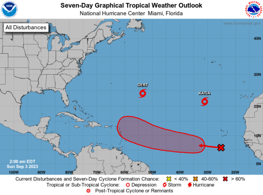
Active Systems: The National Hurricane Center is issuing advisories on Tropical Storm Gert, located about 700 miles east-southeast of Bermuda, and Tropical Storm Katia, located about 850 miles north-northwest of the Cabo Verde Islands. Eastern and Central Tropical Atlantic (AL95): A tropical wave located over the far eastern tropical Atlantic is producing disorganized shower and thunderstorm activity to the south-southwest of the Cabo Verde Islands. Environmental conditions appear conducive for some gradual development of this system by the middle part of this week, and a tropical depression is likely to form while it moves westward to west-northwestward at 15 to 20 mph over the eastern and central portions of the tropical Atlantic.
* Formation chance through 48 hours...low...30 percent.
* Formation chance through 7 days...high...70 percent.
$$ Forecaster Pasch
#bot post#meteorology#weather#tropical weather#tropical storm#tropical depression#hurricane#atlantic#atlantic ocean#caribbean#gulf of mexico#noaa#national oceanic and atmospheric administration#nhc#national hurricane center
44 notes
·
View notes
Text
Atlantic Tropical Weather Outlook issued by the National Hurricane Center in Miami, FL, USA
2023-09-28, 14:00 EDT

Active Systems: The National Hurricane Center is issuing advisories on Tropical Storm Philippe, located several hundred miles east of the northern Leeward Islands, and on newly formed Tropical Storm Rina located over the tropical central Atlantic.
&& Public Advisories on Tropical Storm Rina are issued under WMO header WTNT33 KNHC and under AWIPS header MIATCPAT3. Forecast/Advisories on Tropical Storm Rina are issued under WMO header WTNT23 KNHC and under AWIPS header MIATCMAT3.
$$ Forecaster Cangialosi
#bot post#meteorology#weather#tropical weather#tropical storm#tropical depression#hurricane#atlantic#atlantic ocean#caribbean#gulf of mexico#noaa#national oceanic and atmospheric administration#nhc#national hurricane center
14 notes
·
View notes
Text
Atlantic Tropical Weather Outlook issued by the National Hurricane Center in Miami, FL, USA
2023-08-21, 02:00 EDT

Active Systems: The National Hurricane Center is issuing advisories recently upgraded Tropical Storm Gert, located several hundred miles east of the northern Leeward Islands, on Tropical Storm Emily, located a little over 1000 miles west-northwest of the Cabo Verde Islands, and on Tropical Storm Franklin, located over the eastern Caribbean Sea.
Western Gulf of Mexico (AL91): Showers and thunderstorms continue in association with a trough of low pressure located in the eastern Gulf of Mexico. Environmental conditions appear favorable for development of this system while it moves westward at about 15 to 20 mph across the central Gulf of Mexico. A tropical depression or storm is likely to form while it approaches the western Gulf of Mexico coastline by Tuesday. Interests in the western Gulf of Mexico should monitor the progress of this system. Tropical storm watches or warnings may be necessary on Monday for portions of the southern Texas and northern Mexico coastlines.
* Formation chance through 48 hours...high...70 percent.
* Formation chance through 7 days...high...70 percent.
Eastern Tropical Atlantic (AL92): A large area of disorganized showers and thunderstorms over the far eastern tropical Atlantic is associated with a tropical wave located near the Cabo Verde Islands. Environmental conditions appear conducive for gradual development of this system, and a tropical depression is likely to form later this week while it moves west-northwestward across the eastern tropical Atlantic.
* Formation chance through 48 hours...medium...40 percent.
* Formation chance through 7 days...high...70 percent.
&&
Public Advisories on Tropical Storm Emily are issued under WMO header WTNT32 KNHC and under AWIPS header MIATCPAT2. Forecast/Advisories on Tropical Storm Emily are issued under WMO header WTNT22 KNHC and under AWIPS header MIATCMAT2.
Public Advisories on Tropical Storm Franklin are issued under WMO header WTNT33 KNHC and under AWIPS header MIATCPAT3. Forecast/Advisories on Tropical Storm Franklin are issued under WMO header WTNT23 KNHC and under AWIPS header MIATCMAT3.
$$ Forecaster Roberts
#meteorology#bot post#weather#tropical weather#tropical storm#tropical depression#hurricane#atlantic#atlantic ocean#caribbean#gulf of mexico#noaa#national oceanic and atmospheric administration#nhc#national hurricane center
11 notes
·
View notes
Text
Atlantic Tropical Weather Outlook issued by the National Hurricane Center in Miami, FL, USA
2023-08-23, 14:00 EDT

Active Systems: The National Hurricane Center is issuing advisories on Tropical Storm Franklin, located inland over the Dominican Republic. The Weather Prediction Center has issued the final advisory on Post-Tropical Cyclone Harold, located inland over northern Mexico.
Central Subtropical Atlantic (Remnants of Emily): An area of low pressure more than 1000 miles miles northeast of the Leeward Islands (the remnants of former Tropical Storm Emily) continues to produce a large area of disorganized showers and thunderstorms northeast of its center. Upper-level winds are forecast to become more conducive for development by tomorrow, and this system is likely to regenerate into a tropical depression or tropical storm late this week or this weekend when the system moves northward over the subtropical central Atlantic. For additional information on this system, including gale warnings, see High Seas Forecasts issued by the National Weather Service.
* Formation chance through 48 hours...medium...60 percent.
* Formation chance through 7 days...high...70 percent.
Eastern Tropical Atlantic (AL92): Disorganized showers and thunderstorms continue in association with an area of low pressure located several hundred miles west of the Cabo Verde Islands. Environmental conditions appear only marginally favorable for some slow development through early next week while the system moves west-northwestward to northwestward into the central tropical Atlantic.
* Formation chance through 48 hours...low...10 percent.
* Formation chance through 7 days...low...30 percent.
&&
Information on Post-Tropical Cyclone Harold can be found in Public Advisories issued by the Weather Prediction Center, under AWIPS header TCPAT4, WMO header WTNT34 KWNH, and on the web at www.hurricanes.gov.
High Seas Forecasts issued by the National Weather Service can be found under AWIPS header NFDHSFAT1, WMO header FZNT01 KWBC, and online at ocean.weather.gov/shtml/NFDHSFAT1.php
$$ Forecaster Papin/R. Zelinsky
#meteorology#bot post#weather#tropical weather#tropical storm#tropical depression#hurricane#atlantic#atlantic ocean#caribbean#gulf of mexico#noaa#national oceanic and atmospheric administration#nhc#national hurricane center
11 notes
·
View notes
Text
Atlantic Tropical Weather Outlook issued by the National Hurricane Center in Miami, FL, USA
2023-11-06, 19:00 EST

Tropical cyclone formation is not expected during the next 7 days.
$$ Forecaster Bucci
#bot post#meteorology#weather#tropical weather#tropical storm#tropical depression#hurricane#atlantic#atlantic ocean#caribbean#gulf of mexico#noaa#national oceanic and atmospheric administration#nhc#national hurricane center
6 notes
·
View notes
Text
Atlantic Tropical Weather Outlook issued by the National Hurricane Center in Miami, FL, USA
2023-09-03, 14:00 EDT

Active Systems: The National Hurricane Center is issuing advisories on Tropical Storm Gert, located over the central subtropical Atlantic, and Tropical Storm Katia, located over the eastern subtropical Atlantic. Central Tropical Atlantic (AL95): Showers and thunderstorms associated with a tropical wave located several hundred miles southwest of the Cabo Verde Islands have become better organized since yesterday. Environmental conditions are forecast to be conducive for further development, and this system is expected to become a tropical depression around midweek. Additional strengthening is likely late this week while the system moves westward to west-northwestward at 15 to 20 mph over the central and western portions of the tropical Atlantic.
* Formation chance through 48 hours...medium...50 percent.
* Formation chance through 7 days...high...90 percent.
Eastern Tropical Atlantic: A tropical wave over western Africa is forecast to move offshore in a few days. Environmental conditions could support some slow development starting midweek while the wave moves to the west- northwestward at about 15 mph over the far eastern tropical Atlantic.
* Formation chance through 48 hours...low...near 0 percent.
* Formation chance through 7 days...low...30 percent.
$$ Forecaster Blake
#bot post#meteorology#weather#tropical weather#tropical storm#tropical depression#hurricane#atlantic#atlantic ocean#caribbean#gulf of mexico#noaa#national oceanic and atmospheric administration#nhc#national hurricane center
8 notes
·
View notes
Text
Atlantic Tropical Weather Outlook issued by the National Hurricane Center in Miami, FL, USA
2023-08-19, 14:00 EDT
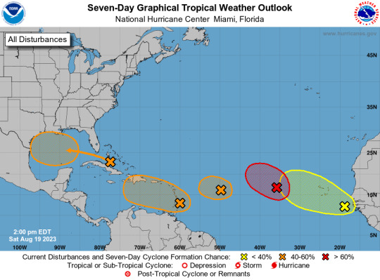
Eastern Tropical Atlantic (AL98): Shower and thunderstorm activity continues in association with a broad area of low pressure located several hundred miles west of the Cabo Verde Islands. Environmental conditions appear generally favorable for further development of this system, and a short-lived tropical depression is likely to form this weekend while it moves west-northwestward or northwestward at about 10 mph across the eastern tropical Atlantic. By early next week, upper-level winds over the system are forecast to increase, and further development is not expected.
* Formation chance through 48 hours...high...70 percent.
* Formation chance through 7 days...high...70 percent.
Central Tropical Atlantic (AL99): An area of low pressure located roughly halfway between the Cabo Verde Islands and the Lesser Antilles is producing disorganized showers and thunderstorms east of the center. While environmental conditions are only marginally conducive, a short-lived tropical depression could form in the next day or so while the system moves west-northwestward at 10 to 15 mph across the tropical Atlantic. After that time, additional development is not anticipated since upper-level winds are expected to become increasingly unfavorable.
* Formation chance through 48 hours...medium...50 percent.
* Formation chance through 7 days...medium...50 percent.
Near the Windward Islands (AL90): A broad area of low pressure has formed near the Windward Islands, shower and thunderstorm activity has become better organized since yesterday. Some additional development of this system is likely and a tropical depression could form by early next week while this system moves westward to west-northwestward at 10 to 15 mph, across the Lesser Antilles and over the eastern and central Caribbean Sea. Regardless of development, heavy rainfall is possible over portions of the Windward Islands during the next couple of days. Interests in the eastern and central Caribbean should monitor the progress of this system.
* Formation chance through 48 hours...medium...40 percent.
* Formation chance through 7 days...medium...60 percent.
Western Gulf of Mexico: An area of disturbed weather located near the northwestern and central Bahamas is expected to move into the Gulf of Mexico by early next week, where a broad area of low pressure is expected to form. Some slow development of this system is possible thereafter, and a tropical depression could form as it moves westward and approaches the western Gulf of Mexico coastline by the middle of next week.
* Formation chance through 48 hours...low...10 percent.
* Formation chance through 7 days...medium...50 percent.
Near the coast of Africa: A tropical wave located near the western coast of Africa is producing a large area of disorganized showers and thunderstorms. Some slow development is possible while it moves generally west-northwestward across the tropical eastern Atlantic during the next several days.
* Formation chance through 48 hours...low...near 0 percent.
* Formation chance through 7 days...low...20 percent.
$$ Forecaster Bucci/Papin/Cangialosi/Brennan
#meteorology#bot post#weather#tropical weather#tropical storm#tropical depression#hurricane#atlantic#atlantic ocean#caribbean#gulf of mexico#noaa#national oceanic and atmospheric administration#nhc#national hurricane center
10 notes
·
View notes
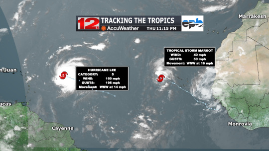
Text
Atlantic Tropical Weather Outlook issued by the National Hurricane Center in Miami, FL, USA
2023-09-08, 08:00 EDT

Active Systems: The National Hurricane Center is issuing advisories on Hurricane Lee, located several hundred miles east of the northern Leeward Islands, and on Tropical Storm Margot, located over the eastern tropical Atlantic.
Tropical cyclone formation is not expected during the next 7 days.
&&
Public Advisories on Margot are issued under WMO header WTNT34 KNHC and under AWIPS header MIATCPAT4. Forecast/Advisories on Margot are issued under WMO header WTNT24 KNHC and under AWIPS header MIATCMAT4.
$$ Forecaster Kelly
#bot post#meteorology#weather#tropical weather#tropical storm#tropical depression#hurricane#atlantic#atlantic ocean#caribbean#gulf of mexico#noaa#national oceanic and atmospheric administration#nhc#national hurricane center
6 notes
·
View notes
Text
Atlantic Tropical Weather Outlook issued by the National Hurricane Center in Miami, FL, USA
2023-07-15, 08:00 EDT

Active Systems: The National Hurricane Center is issuing advisories on Subtropical Storm Don, located over the central Atlantic.
Tropical cyclone formation is not expected during the next 7 days.
$$ Forecaster Blake
#meteorology#bot post#weather#tropical weather#tropical storm#tropical depression#hurricane#atlantic#atlantic ocean#caribbean#gulf of mexico#noaa#national oceanic and atmospheric administration#nhc#national hurricane center
7 notes
·
View notes
Last Seen Blogs

mysticalflyte
Colorful Silence

myfuturespast
Some Things Are Better Left Unsaid But; Seen!

karenfordonte
Caring For Donte

osamaelemary
Osama Elemary

germenis
"What an excellent day for an exorcism."