#barren limestone terrace
Text
maria de mendoza / 𝒐𝒑𝒆𝒏 𝒔𝒕𝒂𝒓𝒕𝒆𝒓.
chelsea house, the grey's riverside abode.
It had been many years since Maria had foot on English soil, and now, back in London –– a place she thought only to return with a warrant for arrest looming over her raven head –– the duquesa had grown to relish retracting the steps of her beloved mistress, familiarising herself with the realm Mary Tudor had once called home. The country, this misty prison, to which Catalina de Aragón had surrendered her fealty, had enriched its barren lands with a bevy of stillborn babes and one miraculous daughter to survive infancy –– Mary, la reina, consort of the richest and most powerful dynasty in Europe.
But with la concubina and her bastards imperiously lodged at Hampton Court, Maria had refused to dance attendance unto the Boleyns with her presence; through Spain's ambassador to England, the duchess feigned illness, a fear of unclean airs, and instead accepted an invitation to sojourn at the Grey's riverside manor, Chelsea House, at the generosity of the Suffolk Dowager –– a kinswoman and, perhaps ever more saliently, a devout ( and recusant ) Catholic. With its red-brick terraces, made a pale pink by the late-summer sun, abundant orchards, and lavish knot gardens, Chelsea Place suited the duchess soundly; reminding her, a mere trifle, of the limestone fortresses and bountiful courtyards of Alcalá de Henares, shaded by ancient trees dappled with ripe apricots.
Taking her morning stroll by the river, Maria nodded determinedly, serenely, when her lady's maid –– Donna Beatriz –– informed her that she had received a visitor. She waited by the entrance of the glass-paned greenhouse for her summons, twisting her crimson mouth into a smile. 'I hope you did not find the journey from Court too strenuous.' Raising her hand in greeting, glittering in the light with precious jewels, Maria swept into a curtsy. 'You are kind to visit me here in Chelsea; I admit to finding my lodgings here much more comfortable than by the bustle of court.'
'Come, we shall take clean airs and walk as we speak. Then, you shall join us for dinner, no? Or must you go so soon?'

8 notes
·
View notes
Photo
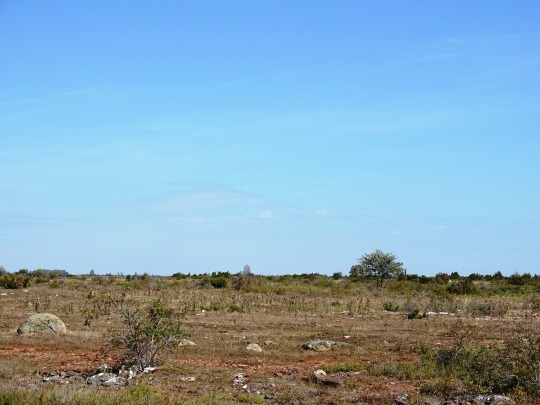
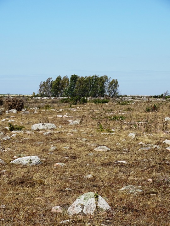
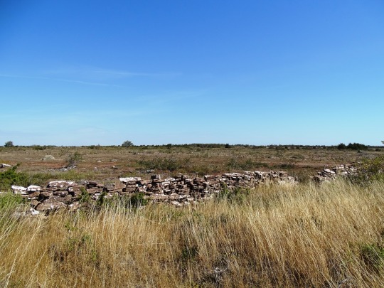

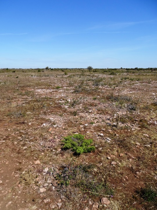
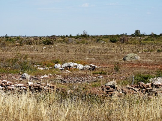
Stora Alvaret, Sweden (No. 1)
Stora Alvaret is an alvar, a barren limestone terrace, in the southern half of the island of Öland, Sweden. Stora Alvaret is a dagger shaped expanse almost 40 kilometres (25 mi) long and about 10 kilometres (6 mi) at the widest north end. The area of this formation exceeds 260 square kilometres (100 sq mi), making it the largest such expanse in Europe and comprising over one fourth of the land area of the island.
Because of the thin soil mantle and high pH levels, a great assortment of vegetation is found including numerous rare species. Stora Alvaret is not devoid of trees, contrary to a common misconception; in fact, it holds a variety of sparse stunted trees akin to a pygmy forest.
Stora Alvaret falls within UNESCO's Agricultural Landscape of Southern Öland, 56,323 hectares (217.46 sq mi), which was designated World Heritage Site due to its extraordinary prehistory.
The limestone plain was created by glacial action from earlier ice age advances. The limestone formation itself was created about 500 million years ago in more southerly seas. Gradually hardening into limestone and drifting northward, the limestone of Stora Alvaret contains a rich fossil record of some of the marine creatures who contributed to it. For example, orthoceratites are found in some of the present day structures on the island.
Only as recently as 11,000 years ago did the first portions of the island of Öland emerge from the Baltic Sea, after the overpressure of the last glaciers was relieved by melting. Over the next several thousand years, more ice melted and the first wave of large mammals including humans migrated across the ice bridge from the mainland. Finally a thin soil mantle (only two centimetres at the deepest) was formed by plant colonisation of the bare limestone and some wind driven deposition, to create the alvar formation of the present. In many places the limestone has no soil whatsoever upon it.
Source: Wikipedia
#Agricultural Landscape of Southern Öland#Stora Alvaret#landscape#travel#countryside#tourist attraction#landmark#UNESCO World Heritage List#Sweden#Sverige#Scandinavia#Northern Europe#summer 2020#vacation#flora#nature#rock#grass#Öland#Kalmar County#World Heritage Site#free admission#stone fence#barren limestone terrace#original photography
2 notes
·
View notes
Text
[ad_1]
The soaring spires of rock, alpine meadows and turquoise lakes of the Dolomites are simply stunning. Here’s how to capture the highlights of this remarkable landscape on a 1-week road trip itinerary.
There are few experiences more enjoyable than an Italian Dolomites road trip.
Soaring spires of rock rise above swaying alpine meadows with mountain top rifugios providing sweeping views of dramatic landscapes. World-class wineries serve up Italian classics with hearty German influences.
But the true magnetism of this UNESCO world heritage site is the hiking and outdoor opportunities. Take a manageable meander around an idyllic lake or clamber a rocky outcrop to a mountain-top lagoon. Walk through forested paths or cycle on the highest alpine meadow in the world.
Our 1-week Dolomites road trip captures the highlights of the area. We spend 4 days hiking so you can rest in between, visit a winery, take a scenic drive, or simply put your feet up.
You’ll need your own car, a pair of decent hiking boots, a sense of adventure, and a willingness to explore one of the most beautiful places in the world.
Booking your trip via the links on this page (or on our book page) will earn us a small commission, at no extra cost to you. Thanks for your support – Paul & Mark.
ABOUT THIS GUIDE
DOLOMITES ROAD TRIP ITINERARY
This guide covers our recommended itinerary for spending one week in the Dolomites, structured so you can enjoy some excellent hiking with rest days in beautiful locations.
MAP – DOLOMITES ITINERARY
Maps.me can be very useful when hiking. It has a more extensive set of maps than Google and works offline for when you are deep in the valleys. All the main sights listed in this Dolomites itinerary are included on the below map.
>>
How to use this map / Click on the top left of the map to display the list of locations, then click on the locations to display further information. Click on the top right corner of the map to open a larger version in a new tab or the star to save to your Google Maps.
DAY 1 – THE GREAT DOLOMITE ROAD & PASSO PORDOI
Stay – Cortina | Travel – 4 hours 15 minutes from the airport to Cortina dʼAmpezzo.
GREAT DOLOMITE ROAD & LAGO DI CAREZZA
Start your Dolomites itinerary by exploring the stunning Great Dolomite Road which runs between Bolzano and Cortina d’Ampezzo collecting dramatic mountain scenery.
From Bolzano take the SS241 towards Nova Levante where you’ll see magnificent views of the Catinaccio. Soon afterward, hop out of the car and visit the shimmering turquoise waters of Lago di Carezza, mirroring the spiky Latemar mountains.
Continuing, the road crosses the Costalungo Pass and drops into Val di Fassa. Turn left onto the SS48 to Canazei.
LAGO DI CAREZZA
PASSO PORDOI
Just through Canazei, the road winds to Passo Pordoi. It takes 22 hairpin bends to reach the top of the pass. Here, take the cable car to the 2,950m Sass Pordoi viewing terrace.
To the west there are sensational views of the massive limestone blocks of the Sella and Sassolungo massifs. To the east lies the barren moonscape of Piz Boe. The rifugio on the viewing terrace is a great spot for lunch.
SASS PORDOI
RIFUGIO LAGAZUOI
Back in the car, take the 33 hairpins that descend down into the valley that sits beneath Marmolada and its glacier. The road follows the valley through Arabba and Andraz before heading north to Passo Falzarego.
Take the cable car to the 2,835m high Rifugio Lagazuoi. The views are excellent, and you can also explore the trenches and tunnels from the First World War.
Returning to the car head east to finish your drive in Cortina dʼAmpezzo.
WHERE TO STAY IN CORTINA DʼAMPEZZO
For simple furnishes and great views of the mountains, Hotel Al Larin is a great budget choice.
Just a 10-minute walk from the centre of town, Hotel Villa Gaia has a traditional alpine feel.
At the top-end Cristallo Resort & Spa has all the luxury you’d expect from a 5-star resort.
RIFUGIO LAGAZUOI
DAY 2 – THE ICONIC TRE CIME DI LAVAREDO
Stay – Cortina | Travel – 1 hour 40 minutes from Cortina to Rifugio Auronzo and back
Tre Cime di Lavaredo are three soaring pinnacles of rock and the hike around them is one of the best things to do in the Dolomites. The most famous view is just north of Drezinnenhütte: a magnificent rifugio tucked into the rock and scree.
The only way to get the view is to walk, and it’s one of the best in the Dolomites.
To start the hike, drive from Cortina to the trailhead at Rifugio Auronzo (45 minutes). On the way, stop at Lago Misurina and Lago Antorno. Both are beautiful lakes with views up to Tre Cime & Cadini massifs.
The trail is just over 10 kilometres with 400 metres of ascent and descent and takes just under 3 hours and 30 minutes. You can find all the details and more information on our guide to hiking Tre Cime.
After the hike, return to Cortina via Lago di Landro for some late afternoon views back to Tre Cime from the Zinnenblick car park.
TRE CIME
DAY 3 – LAGO DI BRAIES & VAL DI FUNES
Stay – San Pietro in Val di Funes | Travel – 2 hours, 30 minutes Cortina to Val di Funes via Lago di Braies
Lago di Braies and Val di Funes are two of the most beautiful destinations to see on our Dolomite road trip itinerary. Tucked into the northern valleys they are only a short drive apart, making for an excellent, relaxing way to spend day 3 of our Dolomites road trip itinerary.
LAGO DI BRAIES
Begin the day by taking the 1-hour drive to Lago di Braies. The turquoise waters of this picture-perfect lake sit beneath the dramatic craggy buttresses of Croda del Becco.
It’s a remarkable sight and worth savouring from the shoreline. There is a 1-hour walk around the lake, or you can hire a boat.
Back in the car, explore more of the Braies Valley. Only a few kilometres from the very popular lake, it is strangely quiet. In particular, the huts and flower-filled meadows that surround the ruined hotel in Bagni di Braies Vecchia is well worth the short detour. The full details are in our guide to Lago di Braies.
VAL DI FUNES
Next, drive to Val di Funes. The churches of San Giovanni and Santa Maddalena backed by the jagged peaks of the Puez-Odle massif are a photographer’s dream.
Take some time to amble along the Panoramaweg and Sunnenseitenweg paths that meander through the meadows. It’s a beautiful spot to stroll in the fading light. We cover more great things to do in the area in our guide to Val di Funes.
Spend the night at San Pietro in Val di Funes.
WHERE TO STAY IN VAL DI FUNES
There are several towns dotted about Val di Funes, however San Pietro is the largest with the most facilities. It’s also a lovely spot with great views.
Fallerhof is an unlikely budget option in such a popular destination.
The balconies at Haus Puez has the prime views.
Proihof is another great choice set among the rolling fields of the valley.
DAY 4 – SECEDA & ALPE DI SIUSI
Stay – Ortisei | Travel – 40 minutes from Val di Funes to Ortiseis
The Puez-Odle massif that forms the magnificent backdrop to Val di Funes doesn’t just look good from afar. Up close those spiky peaks appear like the teeth of a mangled saw. And there is no better place to see this dramatic mountain scenery than from the top of the Seceda cable car.
SECEDA RIDGELINE
Drive to Ortisei from Val di Funes (40 minutes) and take the cable car to the Seceda ridgeline. After a short walk, the reward is a magnificent array of vertiginous alpine peaks. Explore the ridge, grab a coffee at one of the rifugios and then take the car back down.
ALPE DI SIUSI / SEISER ALM
Next, head up to Alpe di Siusi (Seiser Alm) – the 2,000-metre high alpine meadow. Many head up here to hike, but the rolling meadows are vast so it’s better to hire a bike to see all the highlights. The Bamby Bike Rental at the bottom of the lift in Ortisei rents a range of bikes (including e-bikes) for a full or half-day.
Take the bike up on the cable car and enjoy the magnificent meadow views. Make sure to stop at Saltria; the views across the meadows and up to Sassolungo are remarkable.
Take the path that twists through the valleys back to Ortisei. It takes just over an hour.
WHERE TO STAY IN ORTISEI
Residence Larciunei is a family run chalet smack in the centre of Ortisei with fully equipped kitchenettes.
Hotel Luna Mondschein is an elegant establishment in the centre of town with all the facilities you could ask for.
Ten minutes away, Chalet Pra Ronch is a good choice in the picturesque town of Selva di Val Gardena.
DAY 5 – HIKING THE SASSOLUNGO-LANGKOFEL CIRCUIT
Stay – Ortisei | Travel – 1 hour from Ortisei to Passo Sella and backs
What makes the Dolomites so spectacular are the near-vertical peaks that suddenly protrude like a knife through swaying green meadows. And nowhere is this dramatic contrast more emphatic than at the Sassolungo / Langkofel massif. So today drive to the Passo Sella Car Park to start one of the top hikes in the Dolomites.
It’s a 6-hour, 17.6-kilometre walk with 1,000 metres of ascent and descent. But if you are up for the challenge it is a truly memorable day hike. Set off early, take your time and recharge at many of the rifugios along the route.
All the details are on our Sassolungo / Langkofel hiking post.
DAY 6 – TRENTO & THE TRENTINO VALLEY
Stay – Trento | Travel – 2 hours, 15 minutes from Ortisei to Trento using the SS12
Trento is a beautiful town in a beautiful valley and a great place to wind down for a day. Hop in the car and take the scenic SP64 and LS24 through Suisi and Presule towards Bolzano before entering the Trentino Valley.
The old main road (SS12) winds around the valley and through picturesque villages. Potter round the beautiful pastel-coloured buildings, little gardens, and churchyards.
When it’s time for lunch we recommend Alois Lageder, a family vineyard run on biodynamic principles. However, there are plenty of other fantastic wineries which we cover in our Italian Dolomites guide.
In the afternoon head to Trento and explore this attractive old town centre. The highlight is the Piazza Duomo backed by the Cattedrale di San Viglio.
WINERIES IN TRENTINO
DAY 7 – THE BRENTA DOLOMITES
Stay – Madonna di Campiglio | Travel – 1 hour, 30 minutes Trento to Madonna
The imposing massif of the Brenta Dolomites is an under-visited part of the area, but it’s well worth a visit on this Dolomites itinerary. Today, explore this UNESCO World Heritage Site for a hike in an otherworldly, alpine wilderness.
GROSTÈ GONDOLA LIFT
Drive to Madonna di Campiglio (1 hour, 30 minutes from Trento) and take the Grostè Gondola Lift to start the hike.
From the top cable car station, head southwest on path 316, weaving in and out of the towering peaks before arriving at Rifugio Tuckett (1 hour, 30 minutes). This is one of the best-located huts in the Dolomites, surrounded by towering rock.
RIFUGIO TUCKETT & BRENTEI
From Rifugio Tuckett, there are two options to make your way back down.
Option 1 — Firstly, you could take path 317 to Rifugio Casinei then on to Rifugio Vallisnella and catch the bus to Madonna di Campiglio. This is a 3-hour walk.
Option 2 — The second option is to take path 328 and follow the contour around the massif, joining path 318 which travels deep into an amphitheatre of towering peaks. Right in the centre of this wonderland of rock sits Rifugio Brentei – an excellent place to stop. From here take the steep descent via Rifugio Casinei to Rifugio Vallisnella. This option is a 5-hour walk.
Bus to Madonna di Campiglio // The bus from Rifugio Vallisnella to Madonna di Campiglio runs every 20 to 30 minutes. If you’re up for it, you can just keep walking into Madonna di Campiglio which is an additional 4.5 kilometres.
WHERE TO STAY IN MADONNA DI CAMPIGLIO
BRENTA DOLOMITES
HOW TO GET TO THE DOLOMITES
The Dolomites is a large mountain range in northeastern Italy.
As a popular location for both skiing and summer hiking, there are plenty of good options for getting to the Dolomites.
BY AIR
The Dolomites is serviced by several international airports. For this road trip itinerary, Verona is the most convenient as it’s easy to get to Cortina and Madonna where we start and finish.
Alternatively, you could also arrive at Venice to the south and Innsbruck to the north. However, to save on accommodation costs, you may want to arrive early in the morning. So, it’s best to check the prices and arrival times from your home airport.
MAIN AIRPORTS SERVICING THE DOLOMITES
(DRIVING DISTANCES TO CORTINA)
CANOVA DI TREVISO
136 kilometres | 1 hour 45 minutes
VENICE MARCO POLO
148 kilometres | 1 hour 50 minutes
INNSBRUCK
164 kilometres | 2 hours 10 minutes
VERONA
265 kilometres | 2 hours 55 minutes
BY TRAIN
Unless you are already in Italy, getting to the Dolomites via train is unlikely to be a good option. The major train stations are no closer than the airports. Additionally, as this is a road trip itinerary, a car is required which is generally easier to organise from an airport.
However, if you are arriving from Italy the nearest train stations to Cortina are Calalzo di Cadore, 35 kilometres to the south, or Dobbiacco, 32 kilometres to the north.
DRIVING IN THE DOLOMITES
For our one-week Dolomites road trip itinerary, you will need to hire a car. This is a road trip to remember. Driving through the remarkable mountain scenery with breath-taking views surrounding you is a fantastic experience.
Here are some tips to help prepare for your Dolomites road trip.
HIRING A CAR IN THE DOLOMITES
Firstly, all roads in the Dolomites are paved. Therefore, regardless of what you might hear online, a 4×4 is not required to drive in the Dolomites. You might enjoy being slightly higher off the ground, but that’s all you’ll need a 4×4 for.
All airports have a good selection of rental car offerings.
Be aware that if you hire a car in Innsbruck you will need to cross the Austria – Italy border. Most car hire companies allow this with no extra fee. However, if you break down or have an accident, you will need to liaise between the Austrian office and the Italian roadside services.
INTERNATIONAL DRIVING PERMIT
For British license holders with a plastic card and photo, an International Driving Permit is not required to drive in Italy, even with Brexit. However, if you have a paper license only, then a 1968 International Driving Permit is required.
Travellers from other countries should check with their local governments.
An International Driving Permit is validation that you have a licence to drive and does not replace your actual license so make sure you bring both.
AUTOSTRADE
Some of the major roads in the Dolomites operate on a toll system called the Autostrade. When you pull up to the toll gates, you’ll receive a paper ticket to keep with you until you arrive at the next toll gate. When you hand over your ticket, the attendant will calculate the charge for you.
Prices for the Autostrade are based on distance. For a journey from Innsbruck to Cortina (180 kilometres), the fee was €7.50.
DRIVING TIPS
The roads in the Dolomites are twisty, scenic, and a joy to drive. It’s pretty straightforward driving, but it can be busy. There are sometimes queues on mountain roads with tourist coaches winding around the hairpins and you are often sharing the road with motorbikes.
The distances may appear short but driving in the Dolomites can take a long time given the twisty roads, so allow plenty of time to get to your destination.
Road signs are in both Italian and German.
BEST TIME FOR A DOLOMITES ROAD TRIP
The hiking season in the Dolomites is relatively short. Snow can hang around on higher ground well into summer, making some of the paths impassable. The cold weather and snow can return as early as October.
The cable cars close at the end of the ski season and while
some of the larger ones reopen in late May, many others don’t return to service until mid-June. Most rifugios also shut after winter, with some not reopening until mid to late June.
Therefore, the best time to do this Dolomites road trip itinerary is from mid-June to late September. The first few weeks of July is ideal when flowers carpet the upper meadows, and the snow should have cleared from the higher trails.
If possible, try to avoid August when the school holidays bring large crowds.
ALTERNATIVE DOLOMITES ITINERARIES
This itinerary moves around quickly in order to capture the best sights and the best hikes the Dolomites has to offer. If you have less time, or you would prefer to move less, here are some alternative itineraries to consider.
ALTERNATIVE 5-DAY DOLOMITES ITINERARY
To reduce this itinerary to 5 days, remove the Brenta Dolomites by following from Day 1 to Day 5, then spend the final day in Trento before flying out. This will still capture some of the best destinations in the dolomites but skips the more remote hiking.
ALTERNATIVE 1-WEEK DOLOMITES ITINERARY
If you have a week to spend in the Dolomites but would like to slow it down a little, skip the Brenta Dolomites and Trento, and add one more night at Val di Funes, and one more night in Ortisei. There are plenty of ways to spend time in Val di Funes and the extra time in Ortisei can be spent in the charming town or exploring Alpe di Siusi in more depth.
ALTERNATIVE DOLOMITES ITINERARY
Finally, if you want to move less, make this a two-centre visit by staying 4 nights in Ortisei and 3 nights in Cortina. These are two popular places in the Dolomites that will allow you to do some great hiking, explore the stunning scenery around Ortisei and Val Gardena, and relax in some of the nicest towns in the Dolomites.
HOW MUCH DOES IT COST TO VISIT THE DOLOMITES?
Compared to many other destinations in the Alps, the Dolomites are relatively cost-effective. You could expect to pay somewhere between €90 – €110 per night for a decent budget hotel. A main course at an inexpensive restaurant is around €15 and a beer is usually €5. Prices will be slightly higher in the rifugios which are often quite remote.
A small/medium hire car will be around €40 per day including fuel.
CABLE CAR COSTS
A significant expense in the Dolomites is the cable cars. As you can see from the below table, none of them are very cheap.
In our opinion, however, they are a necessary expense. Many of the walks in the Dolomites start from the top of a cable car station. Some of them, Seceda for instance, are breathtaking experiences that shouldn’t be missed.
There are family and season tickets that are designed to save money, however, for this itinerary, didn’t find any discount passes they were worth purchasing.
DOLOMITES CABLE CAR DETAILS
SASS PORDOI
hours – 9 AM to 5 PM (Late May to mid-October) | cost – €27 return (adults)
LAGAZUOI
hours – 9 AM – 4:40 PM (Late May to mid-October) | cost – €25 return (adults)
SECEDA
hours – 8:30 AM – 5:30 PM (mid-May to early-November) | cost – €30 one way, €39.50 return (adults)
ALPE DI SUISI
hours – 8 AM – 6 PM (late May to early-November) | cost – €16 one way, €24 return (adults)
GROSTÉ
hours – 8:30 AM – 12:30 PM & 2 PM – 5 PM (mid-June to late September) | cost – €18 one way, €23 return (adults)
THANKS FOR VISITING // WHERE NEXT?
A BIG THANK YOU
We’ve been providing free travel content on Anywhere We Roam since 2017. If you appreciate what we do, here are some ways you can support us.
Thank you!
Paul & Mark
FOLLOW US ON INSTAGRAM
USE OUR RESOURCES PAGE
[ad_2]
Source link
0 notes
Text
The Signs and Empire III:
Aries: An Empire of canyons and clouds. Terrace farms built over boiling mountain springs. Warriors on stilts and fine ebony masks patrol the estuary coasts where salt and stream meet.
Taurus: An empire of auroras and bone. Butterflies from wicker cages carried by nomad priests pollinating evergreen tundra. Tall shapes in the distance, antlers that crest the treetops.
Gemini: An empire of incense and rain. Ancient cities connected by stone highways, aquifers through the mountains large enough for ships. Old forbidden places left dry when the paths were broken.
Cancer: A sleeping empire, buried under stories of faith and gold. Twisted woods and stone circles that never forgot the old ways. Gnarled roots around weapons rusting in shallow graves.
Leo: An empire of words and brass. Grand halls dug into barren limestone desert. Brass domes drilled with holes to let through the starlight. Old books preserved by centuries in the dry dark, pages blank.
Virgo: An empire of memory and exile. An old capital abandoned for fear for what still sleeps beneath it. An empire in diaspora, tied together by the gravity of their sacrifice. Memories of home.
Libra: An empire of wings and stones. Cloaks of brilliant feathers and fine wool. Citadels built on mountains so high, it seems the sun rises beneath them.
Scorpio: An empire of blood and conquest. The dryads that found the old war-saws and breastplates, playing war in the valley where the capital fell. Ash makes for good fertilizer.
Ophiuchus: The Empire Beneath. Exiles from some strange and impossible place, carving out a home on the very edges of existence. Ships of dead men’s fingernails on salted sea, black and deep as the night.
Sagittarius: A lost empire. Old maps carved in stone depicting roads to a great island nation. A land of astronomers and alchemists and priest-kings. Roads that end at rocky shores to a gulf. There is nothing beneath the waves.
Capricorn: The sandstone badlands, the muddy delta to a river that long changed its course. Homes cut into the rock with primitive tools. A grand hall to an ancient and nameless queen, open to the sky. No banners, only blackberry vines.
Aquarius: The empire before. The southern ice cap. Lost expeditions of survivalists and cartographers. Bodies preserved by frost. Strange geometric shapes carved into flesh. A low resonant song in the night.
Pisces: An empire of brass. An empire known only by the corpses of their engines of war. Great worms half-buried in the fields, now overgrown with grasses and wildflowers.
#aries#taurus#gemini#cancer#leo#virgo#libra#scorpio#sagittarius#capricorn#aquarius#pisces#astrology#zodiac#horoscope#the signs#normal horoscope#ophiuchus
2K notes
·
View notes
Photo
Epochal Territories Shoot #6* - 30/12/2020
* = shot on film before on shoots 3 & 4
Colerne might be a quaint village in Wiltshire bordering on the outskirts of Bath, but at the epicentre of the village is what used to be RAF Colerne, but but known as Azimghur Barracks. Situated in North Colerne, there is a distinct difference between the elderly limestone cottages and the barrack-style housing estates for those stationed at the camp. The site was closed as an RAF base in 1976 and immediately was gained control by The Army, with only the RAF briefly coming back in 1993. Now the site is primarily used for military communications and home to the 21st Signal Regiment, which is the only regiment to support the RAF.

As is the norm now, I track my walks to keep a tab of my mileage and step count. This is so I know how much I have walked during the week, which includes walks and going out for runs. This particular walk was 5.3 miles around the airfield with the in-laws, which was a very interesting experience hearing a lot about the history of the camp. Despite the length, it was an enjoyable walk which I could have replicated again and again. I had ventured towards North Colerne a week before this, but I shot film that time and I wanted to replicate some of the images digitally. However this time, I went in another direction and gathered a few more images. The 5D was again around my neck with the Yongnuo 35mm F2, stopped down to F11 and the ISO set to 400. The shutter speed ranged from 1/40s to 1/250s depending on the light and shadows.

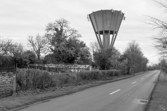
The water tower can be seen for miles and can be used as a navigational beacon when walking around the area. The first thing one notices is the very brutalist design, with harsh straight lines and a bare concrete steel reinforced structure. The tower acts as a brutalist monolith that sticks out above everything else, with a second similarly designed tower a number of miles away. The above picture shows some closer detail of the tower, situated at the Rugby Club, and below close to a set of allotments. I feel that the tower creates a stark contrast between the wintery trees, wonky sheds and shows how altered the landscape is, rather blatantly.

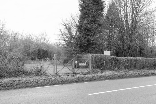
“prohibited place
this is a prohibited place within the meaning of the official secrets act - unauthorised persons entering the area may be arrested and prosecuted
keep out”
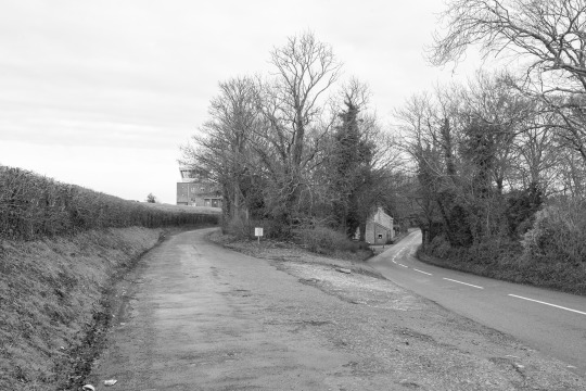
Moving further up the road, the aspects of the airfield become more visible. The control tower and warning sign tells one that this is a military site (sign transcript above). The 1989 Official Secrets Act is set in regard to espionage and spying, creating an offence to disclose any official information without lawful authority. More and more, the military aspects of the village become more clear, and the feeling of unease grows stronger. The airfield is visible from the road, and the poorly kept hedge which is extremely thin, and it is a barren flat land of unused airfield. At this time of year, there is very little to no activity on the camp and it almost looks as if it’s abandoned. The only thing one can hear is distant road noise and the wind blustering past you. I find it strange how RAF bases and military establishments seem to pop up in the middle of the country side, and just like a motorway they are completely anonymous in their location - they could be anywhere if you removed any link to it’s whereabouts.
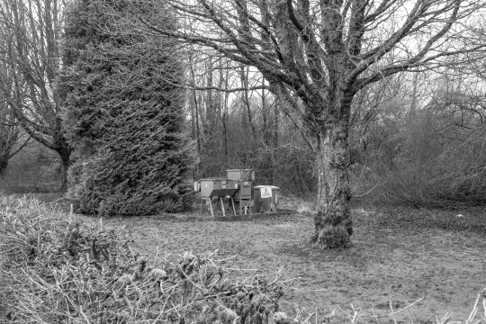
Numerous crash gates litter the perimeter of the camp. Crash gates can be found at high security facilities such as army bases, airports and correctional facilities. In the event of an air crash, these gates are designed to be ran into by fire and rescue vehicles, with the hinges specifically made to break on impact. In 1973, a C-130 Hercules crashed during take-off due to an engine failure, killing all five crew members (on the other side of where these are, towards Lucknam Park). It is a chilling thing to know that a plane crashed in a certain location almost 50 years ago, with no remnants of it happening. My Mother in-law mentioned she remembered it happening whilst she was at school, notably the explosion and the fire. Below is a distribution substation, which distributes electricity to a certain area that needs power. This could power electric fences, camera systems and the aforementioned crash gates.
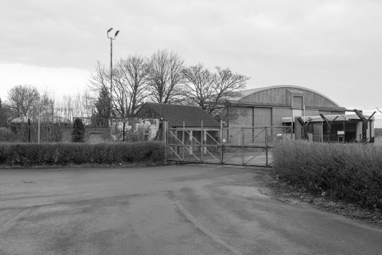

Walking further along, the camp becomes more and more visible, with hangars and entrances making their appearances. On the far left middle of the top photograph is a water tank my Father in-law made almost 30 years ago, taking three days work to put together. I found it interesting to see something that he had built, and stood the test of time. I find the aspect of the military base to be somewhat estranging, because of the military presence in the area making one feel to be uneased with the high barbed wire fences, armed guard situated in tiny boxes and satellite dishes communicating messages. Further down this road it becomes more of a wooded area along the outskirts of the airfield, which my Father in-law mentioned that when he was young, there used to be a pile of plane wreckage where they had scrapped aircraft including DC-10s and even a de Havilland Mosquito.
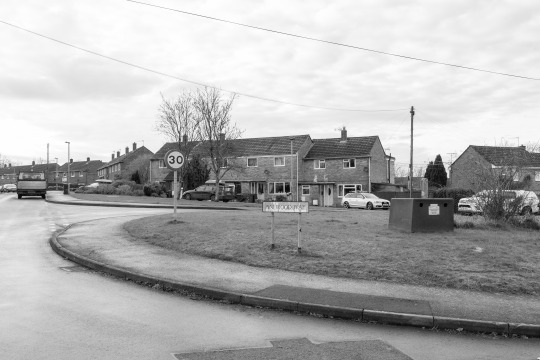

After a bloody great hill, we made our way towards Pinewood and North Colerne, where the vast majority of military personnel live who work at the camp, with a percentage of the houses being sold off for private use. Mostly terraced properties, they are surprisingly large houses which have the odd detached or semi-detached offering. Some of the architecture changes depending on the location, varying from brick and mortar to a cinderblock construction, with the latter being rather bleak due to their grey nature. The quietness is shattered by the noise of screaming children and distant chatter, but the wind still blows creating a still but anxious atmosphere. I felt odd walking around a military housing estate with a camera, and wanted to take a photo and move along as fast as possible.
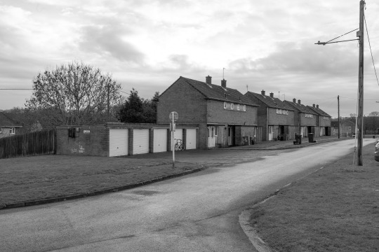

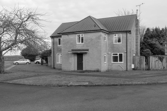
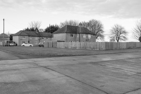
I was drawn to these houses, because the flat land the airfield is placed upon almost seems unending, and the houses seem incredibly drab and bleak, which is extenuated by the pandemic. The houses on the top row take the drab and bleak prize, as they seem to barely get any sunlight due to the four small windows on the first floor. The image below made me metaphorically kick myself, because I wanted to explore North Colerne for Mileage May Vary, but ran out of time. And I wish I had, because sitting sadly was an Alfa Romeo 164, a particularly rare car in the U.K when it was new, and thanks to the ever unreliable nature of them they dwindled to a handful. I also feel that the Alfa adds to the stark mise en scène of the alienating military housing, as its depilated and grubby. My mother law mentioned that a lot of these houses are filled with damp and gave children numerous ailments due to the poor condition of the housing.
Transcript:
cinder block houses bearing down airfield active army base stationed here military communications radar signals to and fro covert government encryption technology run down housing estate for military families playfield basketball hoop for MOD use only aircraft nearby c130 buried in the trees burned wreckage dressed bus stop this used to be an RAF base pivotal aspect of the war spitfire were here once now its digital warfare big red button launch codes obliterated in a matter of moments we will not hesitate to attack if provoked warheads nuclear programmes thousands of times more powerful the fatman retaliation and attack imminent hide under tables and kitchen tables find a shelter cinder block houses
A coda. I found this to be on par in terms of alienating landscapes as Saltram House. This time, the quietness wasn’t disturbed by physical noise, but the background metaphorical underlying buzz of military presence, air crashes and poor housing filled with damp walls and ill children. There was a feeling of unease especially when in the housing area of the camp, with the barbed wire fences surrounding the eerily quite base which is usually a hive of activity. The history of the base is also fascinating to me, as I enjoy learning about the history of areas and have an active interest in aviation history. RAF Colerne/Azimghur Barrack is rich in history stemming from the Second World War to current day.
I am extremely happy with the images I have created, and I am thoroughly enjoying shooting digitally and monochromatically. I feel that I have perfected how I want my work to be aesthetically, in regards to the tonality of the photograph and composition. My only concern is the 5D’s age, and my attempts to find out the shutter count failed miserably, with my camera acting as a form of Schrodinger's Cat. Not knowing the shutter count on a 13 year old digital camera is unnerving, but I have every confidence that it is below Canon’s 100,000 actuation expectancy. Previously mentioned is that I had shot this location a week before, but with the Mamiya 7ii with in colour and B&W. These shall be developed at a later date and shall be uploaded here when they are developed. For now, I am happy to continue to shoot digitally and emulate the look and feel of HP5+, which to me preference is perfect for me, as it contains a good amount of shadow and highlight detail with turning into a horrid HDR mess which usually floods the front page of Flickr. The added noise of the 5D’s older sensor is also rather organic whilst shooting B&W, so I don’t mind the noise either. For once, I am happy to shoot digital over analogue.
Bibliography
Colerne - airfields of Britain conservation trust UK (no date). [Online]. Available at https://www.abct.org.uk/airfields/airfield-finder/colerne/. [Accessed on 31/12/2020]
Crash of a Lockheed C-130K Hercules at RAF colerne: 5 killed (no date). [Online]. Available at https://www.baaa-acro.com/crash/crash-lockheed-c-130k-hercules-raf-colerne-5-killed. [Accessed on 31/12/2020]
0 notes
Photo
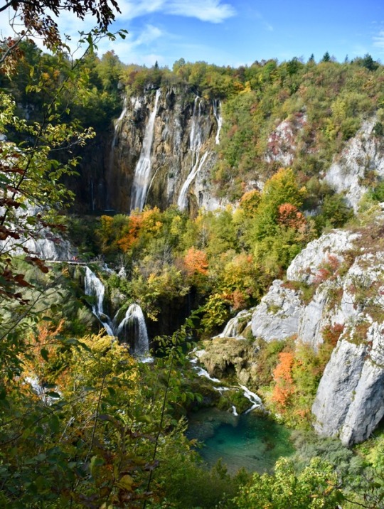
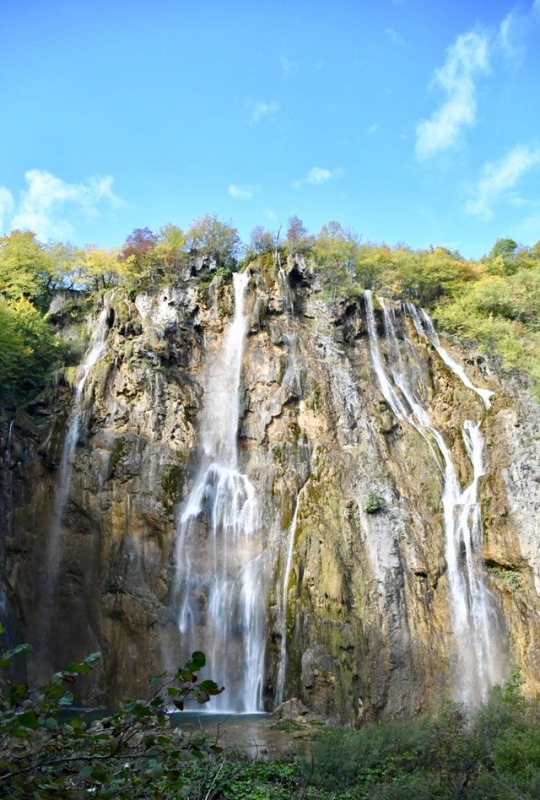
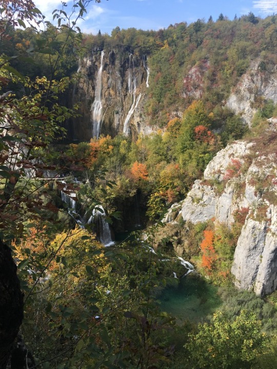
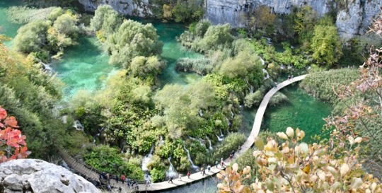
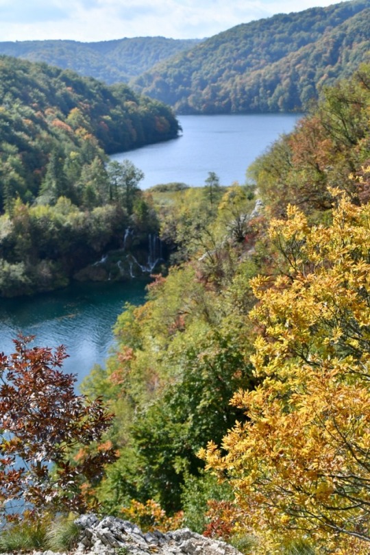
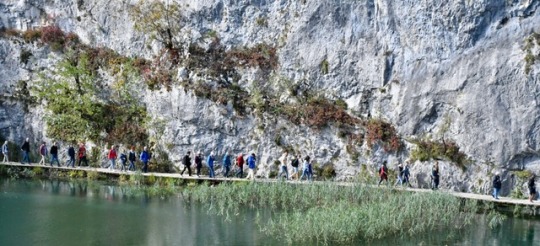
The next day it was a short trip to Plitovice in the heart of the Lake District. The colours became more autumnal as we climbed the mountain passes, and the forests and waterfalls were spectacular.
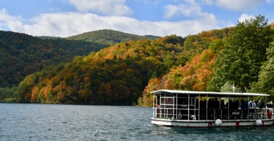
We stopped for a few hours to walk along the gorge, and then caught a boat back to the starting point.
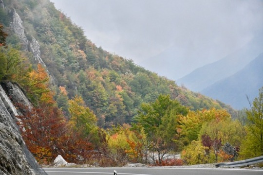
Plitovice national park is well worth a visit. Spectacularly high water falls and terraced water falls separate the lake systems. Its down to a microscopic animal, the algae, that manage to lay down calcium from the limestone dissolved in the water to male the terraces. Autumn was just starting here and its vibrant colours lit the surrounding countryside like a fire. It was time to head for the coast and cross the Kozjacka Praga mountain ranges. The climb was long through marvellous mountains and everchanging scenery and colours. Along the way were more war graves. At the top of the range, over 1000m, the clouds blew in all around us and covered the tops and the road. Visibility went down to about 5m and the driving speed followed to a snails pace. About 15 minutes later after snaking down the mountain side in whiteout conditions the clouds suddenly parted and revealed the Dalmatiin coast in all its glory. The sun was low and a giant silvery sea with a large black island dramatically loomed out of the clouds. The island was Pag, our next destination. Switch back after switchback dominated the road to the coast. Limestone outcrops dominated the scene as well as the very acute angle of the slope towards the sea. Not a place where you would want to fall off. Nearing the ferry port we could see the ferry coming across from the island and hurried down the road to the dock area, well a little fishing village. A few cars were waiting in line and we purchased our ferry ticket, about 260 kuna or $50. Next to the parking lane was a small bar/ cafe. So we enjoyed a beer as we had to wait about an hour before it was due to leave. That hour went by fast and we watched the cars board the ferry before we realised we too should be boarding the ship. So we jumped in the motorhome about 3M away and boarded for the 30 minute trip to Pag island. When you arrive at Pag it seems so deserted both with humans and any form of plant life. Its a rocky barren desert. Our destination was Simuni where there was a camp site.
1 note
·
View note
Text
I think the best way to see anywhere new is to go on an organised excursion. I did just that when I visited Fuerteventura with the excellent Pie de Caracol tours, with driver and guide Luca. It was a long day from 9.00 am until 8pm so we really packed a whole lot in. Normally it’s not so long but because one of the major roads was closed because of a bike race, Luca had to devise some other way to drive around the island.
We started at Corralejo and drove down to La Oliva, bypassing the capital Puerto del Rosario due to road closure, to Betancuria, Ajuy, Costa Calma and back to Corralejo with so many stops along the way. Luca was so informative and had a wealth of knowledge about the island.
Amazingly we saw a rainbow, a miracle when you think there is hardly any rain on this island.
Some of the hundreds of terraces that you see dotted around the island.
Beautiful colours on the volcanoes
Our first stop was the Colonel’s House in La Oliva. There is not much historical information that exists about the house but it is believed to have been built in 1740, for Colonel Melchor de Cabrera Bethencour.
The Colonel’s House
One of the old structures surrounding the house
A few minutes walk away was the old church of Our Lady of Candelaria, where you could wander inside and have a look at the beautiful ceiling. It dates back to the 16th Century and its dark tower is made of volcanic stone.
On the journey towards our next stop of Betancuria we stopped at the famous lookout, where the Morro Velosa warriors are located. Even though this island is quite barren when the sun shines the colours on the volcanoes are amazing.
Morro Velosa Statues
This tiny house is the one you can see in the far distance in the above photo My canon powershot did a fantastic job
Onwards then to Betancuria, an old colonial and picturesque village once the capital of this island. Founded in 1404 this was once a fertile valley due to the fresh water streams nearby, sadly these have long since dried up and the only plants that grow are aloe vera and agave.
BETANCURIA
After a quick bite in Betancuria we headed over to Ajuy, an old fishing village on the West coast. This is where we had lunch and then a cliff top walk along to the caves below.
AJUY
Fish again for lunch
Blue rowing boat just perched on the black sand
Ajuy village overlooking the black sand beach
Long cliff walk to the caves
On the cliff walk
The caves beneath the cliffs
COSTA CALMA
The furthest south we drove was to Costa Calma, a resort area with a natural lagoon. The lagoon fills up in the afternoon creating a shallow area for paddling in contrast to the wild sea beyond.
Hundreds of colourful paragliders
The lagoon from above
Standing in the lagoon looking out towards the Jandia Natural Park
Driving back we stopped at a windmill, salt flats and sand dunes. There is so much to see and do on Fuerteventura but I’m pretty sure we came close to seeing nearly everything with the wonderful tour from Piedecaracol.com.
Lastly some more from my gallery
Lazy cats in Betancuria
An old blue rowing boat in Ajuy
A typical local restaurant in the countryside
A windmill in Tiscamanita
An old limestone house next to the windmill
Salt Flats and Sand Dunes
The Del Carmen Salt Works, the only salt works still in operation in Fuerteventura
An old whale skeleton amongst the salt pans
The sand dunes of Corralejo, now a national park and a favourite with wind and kite surfers
Standing at the top of the sand dunes which cover over 2000 hectares of golden rolling sand
Finally back to our starting point at 8pm. A fabulous and interesting day. Many thanks Luca.
Day tripping around Fuerteventura, Canary Islands – 5.4.2019 – 9.4.2019
Day tripping around Fuerteventura, Canary Islands I think the best way to see anywhere new is to go on an organised excursion. I did just that when I visited Fuerteventura with the excellent…
#Ajuy#Beaches#Betancuria#blogging#Churches#Corralejo#Food#Fuerteventura#Photography#Spain#Tours#travel#Traveldiaries#Travelphotography#Views#Volcanoes
0 notes
Video
youtube
Big Bend National Park Dog Canyon Trail April 2017 Earth Day Special
Big Bend National Park is one of our favorite places on earth. The weather was in the 70's, and it was one of our best trips to the Big Bend National Park. The entrance fee was free on Earth Day, and that was an added surprise. If you haven't made the trip to Big Bend check out the video above and see wonders Big Bend National Park has to offer.
The northernmost trails in Big Bend National Park lead to a pair of narrow ravines in the Santiago Mountains, the long, thin range that forms a natural boundary between the park and the adjacent Black Gap WMA. The shorter of the two is the level, 2-mile path to Dog Canyon, a deep but relatively wide ravine leading right through the mountains to the desert at the far side, and bordered by steep, rocky hillsides interspersed with vertical cliffs. Rather more interesting is the 3.5-mile trail to Devil's Den in the mountain foothills a little way south; the Den is a narrow, enclosed, sheer-walled ravine through whitish limestone strata, containing pour-offs, potholes and terraces - like a slot canyon though not quite as small.
The rougher and less-used path to Devil's Den branches off the Dog Canyon Trail after 1.5 miles and both ravines can be seen via an 8-mile loop hike of which the last mile is a cross-country walk back to the trailhead, a signed parking area along US 385. Dog Canyon The Dog Canyon hike begins at a pullout beside the highway, 3.5 miles south of the park entrance at Persimmon Gap. The canyon is clearly visible to the east as a distinct cleft in the Santiago Mountains, separated by a dead flat desert plain on which grows a sparse mixture of bushes, grasses, yucca and cacti including cholla, opuntia, Texas rainbow cactus and the Turk's head cactus.
The shadeless walk across is not particularly impressive and the surroundings do not change much until after 1.4 miles, where the path drops down into the wide, stony dry wash (Nine Point Draw) that leads to the canyon after a few more minute's walking. The gorge is quite short, less than half a mile, since it cuts through a narrow part of the mountains, and after a few deep bends it emerges into a similarly barren desert landscape on the far side of the hills, where the hike ends.
The limestone rocks in the canyon walls are faded grey-brown in color, old, dusty and weathered in appearance, and distorted in alignment, with some strata in a fault zone upturned by 90°. At the narrowest point the gorge is still 100 feet across, and in all places, the pebbly streambed is bordered by sandbanks and clumps of vegetation. Information Sorce: http://www.americansouthwest.net/texas/big_bend/dog-canyon-devils-den.html
0 notes
Last Seen Blogs

thevibrationelevation
The Vibration Elevation

passwords
Passwords

cyberpunkrick
CP-032

secrets
Untitled

liinwx
coraline