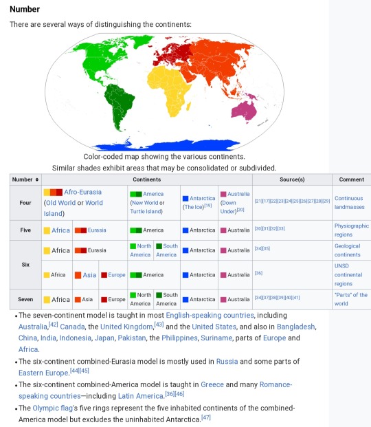
#seven continents
Text
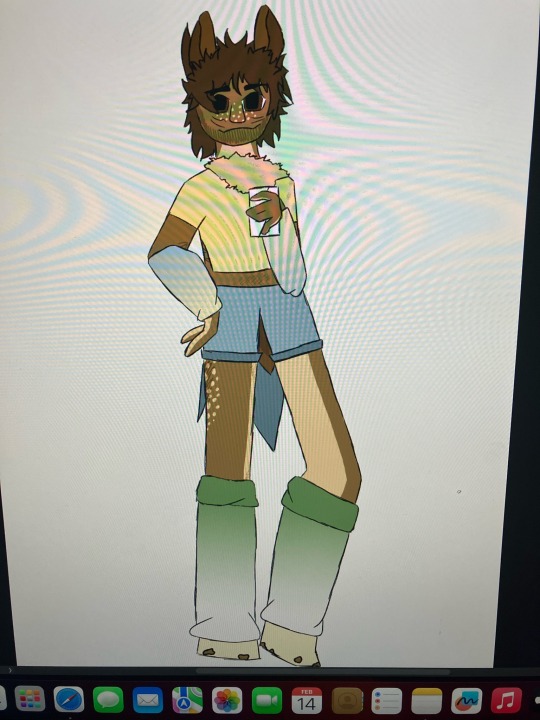


this is the physical embodiment of the continent itself, north america, they use he/they pronouns and his name is nortri (nor-tree) amecia (a(h)m-ee-see-ah)
#north america god#nortri amecia#nortri amecia god#seven cults#seven gods#seven continents#7 gods#7 cults#7 continents#m.w.draws#m.w.notes#m.w.oc notes#my god ocs#my ocs#my oc art#godly oc#godly original character#god original character#my god oc#god oc#oc#ocs#my oc#oc art#mocaps art
3 notes
·
View notes
Photo
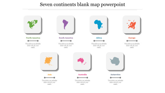
An extraordinary PPT Template with Maps Background to create wonderful PowerPoint Presentation within some minutes. These Seven continents blank map template can be used for both teachers and students for education purpose.
0 notes
Text
Seven continents

The concept Richard Bass and his climbing partner Frank Wells were pursuing was to be the first to stand atop the highest mountain on each continent. Everest, Aconcagua, Denali, Kilimanjaro, Vinson, Mauna Kea, Puncak Jaya / Kosciuszko (the tectonic version).Everest, Aconcagua, Denali, Kilimanjaro, Vinson, Mont Blanc, Puncak Jaya.Everest, Aconcagua, Denali, Kilimanjaro, Vinson, Mont Blanc, Kosciuszko (the 1950s explorer Hackett version).Everest, Aconcagua, Denali, Kilimanjaro, Vinson, Mont Blanc, Mount Wilhelm (the Wilhelm version).Everest, Aconcagua, Denali, Kilimanjaro, Vinson, Elbrus, Puncak Jaya (the Messner version).Everest, Aconcagua, Denali, Kilimanjaro, Vinson, Elbrus, Kosciuszko (the Bass version).Everest, Aconcagua, Denali, Kilimanjaro, Vinson, Elbrus, Mount Wilhelm (Continent).This creates several possible versions of the seven summits: This also gives rise to another list called the " Eight Summits", which includes both Puncak Jaya and Mount Kosciuszko along with the six summits on the other continents. The second one is Puncak Jaya (also known as "Carstensz Pyramid") versus Mount Kosciuszko for the continent of Australia, which depends on whether one includes the Sahul Shelf or only mainland Australia as the continent. The first one is Mont Blanc versus Mount Elbrus for Europe, which depends on whether the crest of the Greater Caucasus Mountains is taken to define the Greater Caucasus watershed which marks the continental boundary between Asia and Europe for the region between the Black and Caspian seas this classification would place Mount Elbrus in Asia instead of Europe. This results in two major points of variation. The seven summits depend on the definition used for a continent – in particular the location of the border of that continent. Different lists include slight variations, but generally the same core is maintained. The Seven Summits are composed of each of the highest mountain peaks on each of the continents. 8 Impact and related climbing list concepts.
1 note
·
View note
Text
What the fuck is wrong with Americans that wearing their flag is considered fashion??
0 notes
Text
punk fagging out on instagram once again and i'm just like. put your money where your mouth is man. let me top.
10 notes
·
View notes
Text
i kinda wanna write a fantasy novel where the setting is a holy roman empire style awful clusterfuck of feudalism location
#my main critique of a song of ice and fire is that the seven kingdoms arent enough like the holy roman empire despite being an entire contin#ent
11 notes
·
View notes
Text
two more weeks of work,,,,,,,,
#which is really just two more days. since i only work sundays#three counting today. still have seven hrs left in my shift. fml#its fine i have the same group i had last week. i like them because theyre mostly continent<3#absolute win for both not breaking my back changing people AND for not getting covered in urine the whole day! yippee!#i do have three inconts today but they're all nice and easy so idc#theres just five weeks left in the semester and then i go home. finally. finally#applying to work at the hospital nearest my house cause i KNOW they do per diem#i dont need the flexibility during the summer but itll be nice once school starts again in august#i cannot BELIEVE im almost done w my second year of college thats so scary. i turn 20 in six months..... eugh#🫀
4 notes
·
View notes
Text
Graceling Realm Discord is still going strong! I figured it's been a couple of years since I've promo'd our server, so I'm giving it another go.
Bookclub is currently re-reading Graceling for the dozenth time. Our next meeting is April 20th and we're reading part 3! Then we're moving on to Fire.
We hope you can join us!
#graceling discord#graceling realm#discord server#kristin cashore#graceling bookclub#graceling#seven kingdoms#royal continent
2 notes
·
View notes
Text
it was supposed to be a joke. me taking the train somewhere in june was supposed to be a joke why am i on the national railway website suddenly weighing my options
#i will probably either do somewhere in germany thats not berlin (most likely) or something like bratislava cause the trains there#are usually direct and as much as i love trains i also dont wanna spend more than like seven or eight hours on it#unless i splurge and make the train ride part of the experience. then i am willing to use the power of schengen and living in the#middle of the damn continent >:3c#erika.txt
2 notes
·
View notes
Text
akihiro absolutely takes gabby through the Gates into random cities to get street food of questionable quality. laura hates it but considering she's busy with the x-men/x-force she really can't stop them. and they both heal anyway so it's probably fine. it's sibling bonding!
#gabby's favorite so far has been yakitori#mostly because she'd never been to japan before#but they've been to six of seven continents this way#akihiro tries to keep it from laura but gabby is too excited about trying new food to be a good liar#and can you blame her? she lived in a box for most of her life#gabby kinney#akihiro#laura kinney#x-men#yes I know fall of x is coming okay just let me have this#they've been through enough on krakoa between the two of them#they deserve to get good things out of living on the island too#and yes my love of sibling fluff doesn't stop with the batfamily#I'm trying to branch back out#fluffy headcanons
18 notes
·
View notes
Text
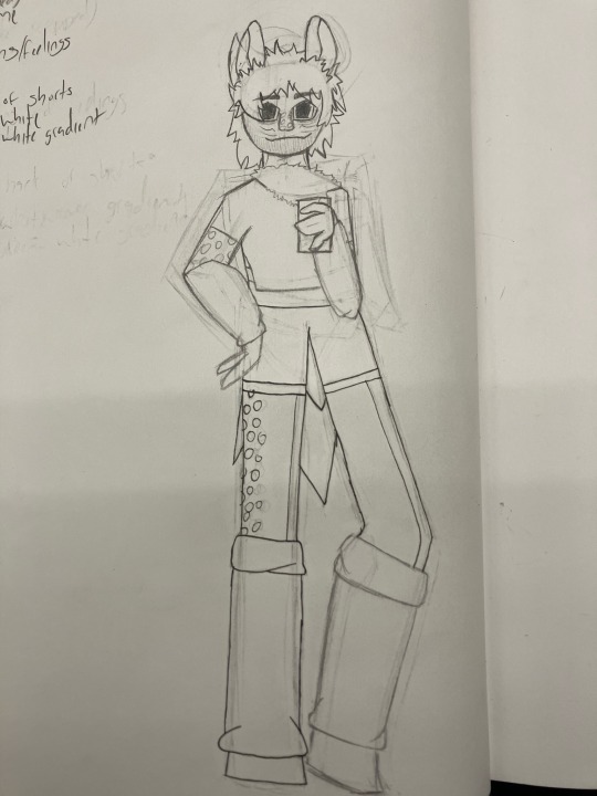
giving the north america god a red bull bc they have to deal with the usa
#north america#north america god#7 gods#7 continents#seven gods#seven continents#7 cults#seven cults#god oc#god original character#godly oc#godly original character#my oc#my ocs#my god oc#my god ocs#worldbuilding#mocaps#my world#my-world-mocaps
0 notes
Text
Editor: So the manuscript is probably going to be ready by 1st June; I was really hoping we be able to publish it in November, so that we could have copies for [huge academic conference]!
Me: ......
Me, internally: Mate, even if you submitted the manuscript today, we wouldn't be able to publish it by November.
#my life#my job#people are always surprised by how long it takes to produce a book#but consider:#it has to be thoroughly checked before it's sent to production so there's no nasty surprises#then copyediting#proof reading#typesetting#creation of index#final cover sign off#printing#amassing of stock#AND it might be printed on another continent and copies will have to be shipped all over the world#AND! this is happening alongside at least a dozen other books at any one time#so yeah#you'll have to wait seven or eight months before your book is ready
4 notes
·
View notes
Text
inka asia itna chhota kyun hai yaaaaaar 😩
#literally just SEVEN shows bhai biggest continent in the world and this what you can give us??????#behenchod abb mai kuala lampur jaungi
17 notes
·
View notes
Note
Udyeubfjebne I forgot to send you the colors. Yellow, Goldenrod, Mahogany, and Pink, but in, like, the mutuals for 10 years affectionate way ❤️
I'm holding out my arm for you to bite adsjkghdjskah ❤
I really wish we could sit and watch teh sun and hang out and listen to music together!! You've been this constant presence in my life for such a long time and it would just be cool to hang out I think 🥺 it'd be fun
#wish we could play genshin together too ahdgkjgkaj#damn you timezones and continents and things#it's sweet and a little funny to me that we've been mutuals for so long but like#didn't message each other for seven years#and then when we did message again it feels like talking to someone i've known Forever#it's really really nice!!#answered#ji-woonhaksslut
2 notes
·
View notes
Text
1. The land of Saptasindhavah (सप्तसिन्धवः)
Since the dawn of civilization, the mighty Himalayas have always protected the people living in Indian sub-continent, not only from natural phenomena like sandstorms originating on central Asia plains or blistering arctic cold winds or great floodwaters sweeping the north Indian plains, that could have created existential problems for the early settlers. The unscalable peaks and ranges of world’s tallest mountain also prevented the barbaric wild Asian steppe hordes, attacking and destroying the inhabitations, including cities and towns of subcontinent, the way they did in China and east Europe.
Yet, in spite of this guardian angel, protecting our borders, wild hordes of invaders and intruders, cruel and murderous tribesmen, monarchs, brave warriors with monarchy aspirations and people who themselves were pushed out from their country, found routes that circumambulated the vast mountain ranges and enter the sub-continent over last two millennia. These intruders and their barbaric armies, created a profound impact on the culture of the sub-continent that had evolved over last five or more millennia, starting from Sindhu-Sarswati Civilization, the Vedic era, Buddhist ideas and finally the Sanatan Dharma. Some of the early intruders adopted to native religions, but some imposed their own religious doctrines, creating a great divisive force that continues to torment the sub-continent, even today.
It so happens that the most profound impact of the intruders took place in a geographical area of the subcontinent, where Sindhu-Sarswati civilization once flourished five or more millennia ago. This land could be rightly called as the heart or core of the sub-continent culture. This region, in the northwest corner of the sub-continent, is none other than the land of seven rivers or Saptasindhavah (सप्तसिन्धवः) of the Vedas.
In the oldest Veda or Rigveda, the sage Angirasa, while offering oblation to Sun God ‘Savita” describes him as,
अ॒ष्टौ व्य॑ख्यत्क॒कुभः॑ पृथि॒व्यास्त्री धन्व॒ योज॑ना स॒प्त सिन्धू॑न् । हि॒र॒ण्या॒क्षः स॑वि॒ता दे॒व आगा॒द्दध॒द्रत्ना॑ दा॒शुषे॒ वार्या॑णि ॥ (1.35.8)
“He has lighted up the eight points of the horizon, the three regions of living beings, the seven rivers; may the golden-eyes Savitā come hither, bestowing upon the offerer of the oblation desirable riches.”
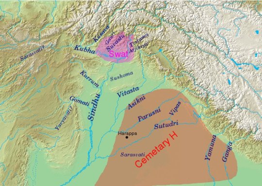
The next question that naturally arises is the names of rivers that constitute this land of seven rivers. Luckily Rigveda helps us even here. The Nadistuti sukta (नदिस्तुति सूक्त), or “the hymn in praise of rivers”, gives us names of these seven rivers for the reconstruction of the geography of this area.
The first and foremost river that this Sukta (10.75.1) mentions is obviously Sindhu or The Indus, the mightiest of them all. Other rivers that are mentioned (10.75.5) in east to west direction are Sarasvati, Shutudri (Sutlej), Parushni (Iravati, Ravi), Asikni (Chenab) and finally Vitasta (Jhelum). This defines the land of seven rivers as the region that begins with Sarswati in the east, but does not end with Indus in the west.
The next verse (10.75.6) describes the tributaries like Kubha (Kabul River), Gomati (Gomal) and Krumu (Kurram),that merge with Sindhu in the plains. Using this information, we can create a map of the landmass, which Rigveda describes as ‘Saptasindhav’. We must also include here the plains, west of Indus River that stretch to the mountains and also the Basin of no longer visible Sarswati River, now found only through archaeological and satellite data. However, we shall not indulge in that endeavor as it is unrelated to our subject matter. Figure 1.1 shows the exact locations of these rivers except River Sarswati.
By Dbach...
View On WordPress
0 notes
Text
When you get down to it, the politics around the continents is sort of insane. Say you don't consider North and South America separate because the Panama Canal is artificial (and only so deep), but what about the Isthmus of Suez? It's entirely natural but humans have expanded the waterways around it artificially. Does that mean Africa is not part of Eurasia?
Do you only consider certain continents separate because of continental drift in the recent past? India is considered a subcontinent because it used to be separate from the rest of Asia.
#continents#i was taught there were seven continents BUT...#madagascar is considered a mini continent but greenland is an island???#thank you for being normal australia and antarctica#europe is apparently just a region in asia if you get down to it
0 notes
Last Seen Blogs

ladyculebras
NORMALIZE CANNIBALISM

lidia-lomar
milk & honey


junko-enoshima-in-dark-souls
wearing a miniskirt (in bloodborne)

ianb0hen
"matt's the handsome one"