#promontory fort
Text

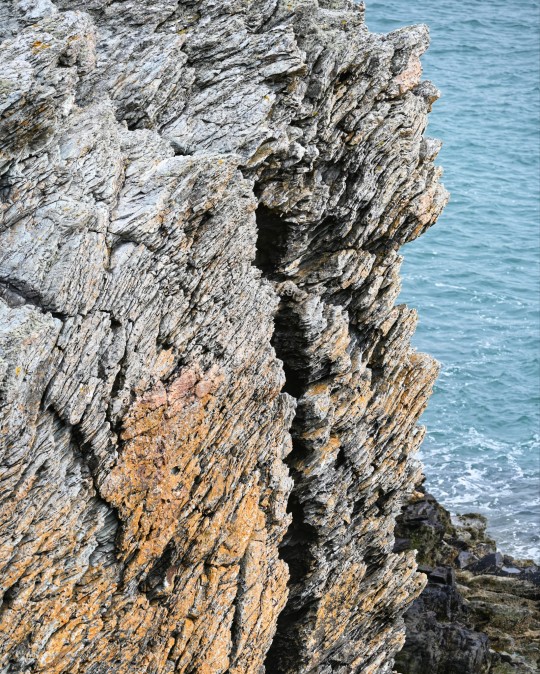
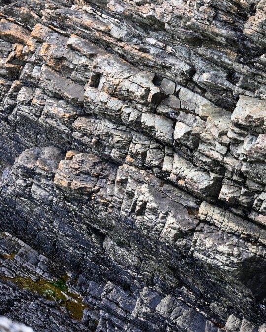
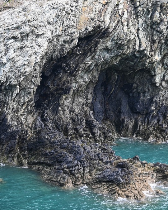
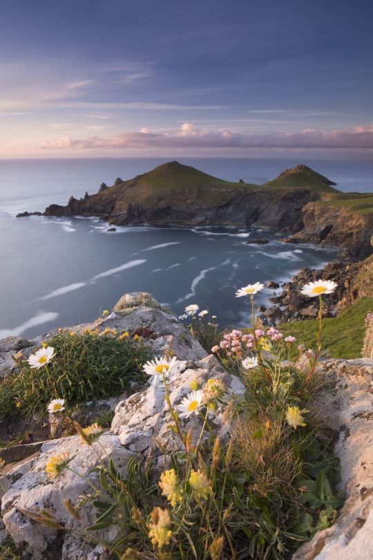
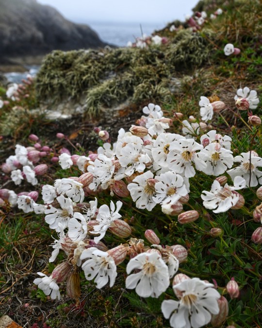
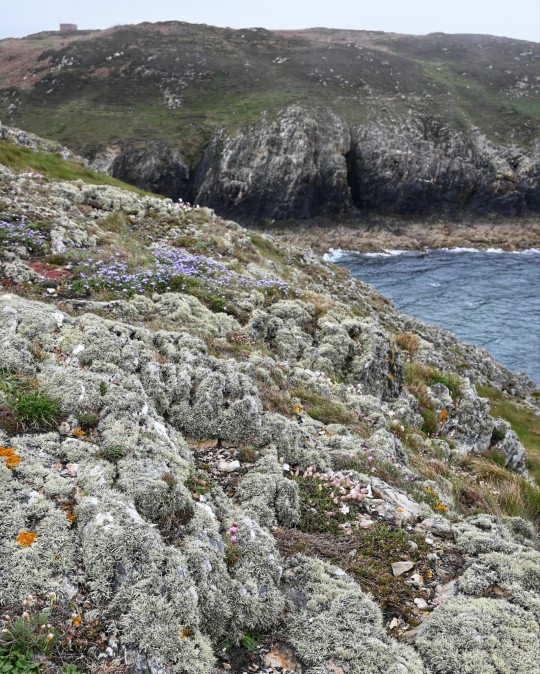
'The Range' Coastal Headlands and Iron Age Promontory Fort, Holy Island, Anglesey, Wales
#coastline#promontory fort#iron age#coastal#landscape#rockscape#wales#prehistoric#prehistory#archaeology#geology#wildlife#outdoors#walking#tribal#wild places#ancient sites#ancient living#Anglesey
159 notes
·
View notes
Photo
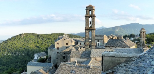


Penta-di-Casinca.
Haute-Corse.
Penta di Casinca et Un village classé orné de pierres grises et de toits en lauzes, posé comme un fort sur son promontoire rocheux qui dévoile un panorama époustouflant sur la mer.
Source: corse2b.
juin 2022.
Penta-di-Casinca.
Upper Corsica.
Penta di Casinca and A listed village adorned with gray stones and slate roofs, set like a fort on its rocky promontory which reveals a breathtaking panorama of the sea.
Source: corsican2b.
330 notes
·
View notes
Text
31.07.2014 - This walk visits an Iron Age promontory fort and some Bronze Age burial mounds, also featuring a famous war...
5 notes
·
View notes
Text


Ireland - September 2023 (2) (3) (4) by badnewf
Via Flickr:
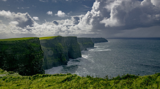
The Cliffs of Moher are sea cliffs located at the southwestern edge of the Burren region in County Clare, Ireland, and run for about 9 miles. At their southern end, they rise 390 feet above the Atlantic Ocean at Hag's Head, and, 5 miles to the north, they reach their maximum height of 702 feet.
They take their name from an old promontory fort called Mothar or Moher, which once stood on Hag's Head, the southernmost point of the cliffed coast, now the site of Moher Tower. About 1.5 million visitors come to the site each year. The cliffs consist mainly of beds of shale and sandstone and were formed between 313 and 326 million years ago.
4 notes
·
View notes
Text
The Amnya Site I and its fortifications date back approximately 8,000 and is located on the curve of the Amnya River in Western Siberia.
The Amnya II site was also built 50 meters to the east around this time.
Researchers suspect that a shift in climate roughly 8,000 years ago created the stage for an abundance of seasonal resources in western Siberia, prompting an influx of human migrants.
The West Siberian taiga is a sometimes swampy, coniferous forest habitat present in the subarctic. Around 6,000 BCE, the taiga near Amnya would have hosted herds of elk and reindeer, while the river would have been swimming in fish, like pike and salmonids.
In the subarctic boreal landscapes of the Siberian, 8000 years ago, hunter-gatherers built fortified settlements. The building of fortifications by forager groups has been observed sporadically elsewhere around the world in various—mainly coastal—regions from later prehistory onwards, but the very early onset of this phenomenon in inland western Siberia is unparalleled.
Western Siberia, between the Ural Mountains and the River Yenisei, represents a particularly rich ecosystem from a hunter-gatherer-fisher perspective. Fish, aquatic birds, forest fowl and large game such as elk and reindeer have predictable seasonal behaviours,
#history#archeology#archeologicalsite#discovery#hunter gatherer#siberia#research paper#article#settlement
3 notes
·
View notes
Text
Dunstaffnage Castle

Dunstaffnage Castle (Scottish Gaelic: Caisteal Dhùn Stadhainis) is a partially ruined castle in Argyll and Bute, western Scotland. It lies 3 miles (5 km) NNE of Oban, situated on a platform of conglomerate rock on a promontory at the south-west of the entrance to Loch Etive, and is surrounded on three sides by the sea. The castle and the nearby chapel ruin have been a Historic Scotland property since 1958. Both are Scheduled Ancient Monuments.
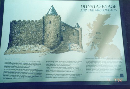
The castle dates back to the 13th century, making it one of Scotland's oldest stone castles, in a local group which includes Castle Sween and Castle Tioram. Guarding a strategic location, it was built by the MacDougall lords of Lorn, and has been held since the 15th century by the Clan Campbell. To this day there is a hereditary Captain of Dunstaffnage, although they no longer reside at the castle. Dunstaffnage is maintained by Historic Environment Scotland, and is open to the public, although the 16th century gatehouse is retained as the private property of the Captain. The prefix dun in the name means "fort" in Gaelic, while the rest of the name derives from Norse stafr-nis, "headland of the staff"
3 notes
·
View notes
Text
Goodnight story
➷➸➹➷➸➹➷➸➹➷➸➹➷➸➹➷➸➹➷➸➹➷➸➹➷➸➹➷➸➹➷➸➹➷➸➹➷➸➹➷➸➹➷
Genre: Fluff
Characters: GN! MC + Luke
Universe: Obey Me!
Warnings: none
Summary: MC tells Luke another version of the Celestial war
Word Count: 906
➷➸➹➷➸➹➷➸➹➷➸➹➷➸➹➷➸➹➷➸➹➷➸➹➷➸➹➷➸➹➷➸➹➷➸➹➷➸➹➷➸➹➷
As promised, you had gone to Purgatory Hall to spend a whole day with Luke.
You had a lot of fun baking pastries and watching cooking videos on DevilTube, but once it was time to sleep, the young angel "refused" to do so.
"MC, I can still stay awake! I am not tired!"
You had looked at him, sighing. You promised Simeon that you would go to sleep at an appropriate time to get up in time to go to school and you didn't want to disappoint the angel.
You sat inside the pillow fort you and Luke had built, bringing a hand under your chin, thoughtful.
What could you come up with?
An idea had flashed in your mind; you would tell him a story.
"Luke, would you like to hear the story they tell us humans about the Celestial War?"
The young angel had looked at you with shining eyes and an intrigued look. After exclaiming a "Yes!" he jumped into the pillow fort and made himself comfortable to listen to the story.
"Do you promise me that we will go to sleep after the story?"
"I promise you, MC"
"So..." you had begun "In the human world, there is a legend that speaks of the war between the Archangel Michael and Lucifer"
Luke had approached you to listen better to you as soon as you had made Michael's name and you had smiled, continuing your story.
"On an island in the human world, the story of the Devil's Saddle is told, a rocky promontory that is so named for its curious horse saddle shape."
"But MC, why they talk about Diavolo if you say it was a story about Lucifer?"
You had laughed, confused in his own way. In the human world there was no difference between Lucifer and the Diavolo and so you explained to him the reason for that bizarre name given to the promontory.
"Here, it is said that once good and evil fought each other.
In fact, it is about God, his angels and his beloved who later became a demon: Lucifer."
Luke had murmured a 'tsk' when you said that Lucifer was God’s Favorite and you had tried to stay serious and not laugh.
"I was saying... It is said that that island had attracted Lucifer and his demons for its profound beauty so much so that he wanted to seize it, so God had sent the archangel Michael, with his heavenly militias, to drive Lucifer out with his followers."
You could see Luke watching you in silence, occasionally broken by a "what next?" "And what did Michael do next?"
"The battle was faced in the skies of that promontory, and it is said that the ruinous defeat of Lucifer led to two endings:
The first sees the saddle of Lucifer, unseated from his horse, fall into the waters of the gulf and petrify giving rise to the promontory, the other tells that during the fight Lucifer fell on the promontory giving it the characteristic shape from which it takes its name... although I think he threw Mammon towards the mainland in the grip of a nervous breakdown. Or Asmo. "
Luke had burst out laughing at hearing you say those things, and the image of Lucifer falling and banging his head or throwing away Mammon or Asmo in anger made you laugh too. Poor Mammon wouldn't have liked that part, and neither would Asmo.
"Another story sees God offering as a gift to his angels the possibility of living on Earth if they found a place full of peace and devoid of wickedness where they could settle.
Their research led them to an island free of war and devastation, perfect for living in peace and harmony.
Lucifer and his demons, then, decided to try to sow hatred and weeds among the heavenly creatures, failing miserably and unleashing a war that he would later lose.
Prey to anger Lucifer took the saddle of the horse from which he had been unseated and threw it into the gulf forming the promontory that will be baptized with the name of the Devil's Saddle. "
Luke, intrigued, had asked you if there were also the other brothers in the story and you had replied that most likely they were also present, perhaps there was also Simeon and even poor Levi.
Luke was however satisfied that his adored Michael had defeated Lucifer.
You had spent the rest of the evening talking about the history of the Celestial War and how those two versions didn't look alike at all. Luke had almost managed to get you to tell another story when a yawn on his part brought you back to reality; it was quite late by now.
"Luke, what did you promise me?"
The angel had snorted, getting comfortable to sleep and murmuring a 'and all right, I promised you' before closing his eyes.
You had put yourself next to him, taking a blanket for both of you.
"Thank you for the day, MC"
"Anytime, Luke"
"... tomorrow can you tell the story in front of the brothers? I want to see their faces!"
"You can count on it, Luke. I will tell them that the promontory actually took that shape because Beelzebub ate a piece of it or because Belphie crushed it during a nap."
"I can't wait to see their faces and Satan's for the lack of accuracy of the story"
#obey me one master to rule them all#obey me shall we date#obey me#obey me mc#obey me post#obey me headcanons#obey me x gender neutral reader#obey me luke#obey me lucifer#obey me mammon#obey me beelzebub#obey me belphegor#obey me satan#obey me simeon#obey me leviathan
82 notes
·
View notes
Photo


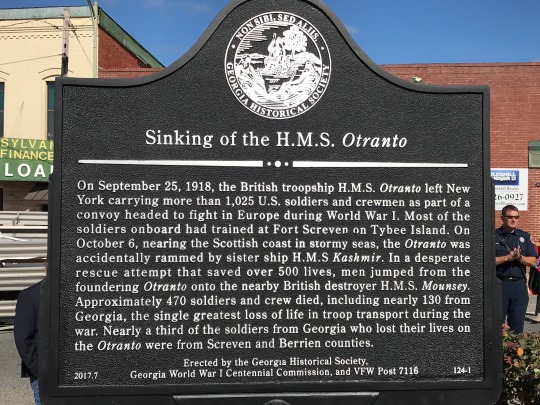


On October 6th 1918 tragedy struck when H.M.S. Otranto sank in Machir Bay off slay after a collision in fog with another ship, HMS Kashmir.
On September 25th, 1918, the British troopship H.M.S. Otranto had left New York carrying more than 1000 U.S. soldiers and crewmen as part of an Allied Forces convoy sailing to fight and on to fight during World War I.
Most of the soldiers on the H.M.S. Otranto had trained at Fort Screven on Tybee Island, Georgia. After crossing the Atlantic Ocean, the convoy entered the Irish Sea. On October 6th, while still a day from port, a storm developed with gale-force winds. During the storm, a large wave struck the H.M.S. Kashmir, another troopship in the convoy, causing it to ram at full steam into the Otranto.
The Otranto sustained a gaping hole in its hull and loss of power, the latter which caused it to drift toward Islay. One of the convoy’s escort destroyers, the H.M.S. Mounsey sailed alongside the much-larger Otranto four times to attempt a rescue. In all, the Mounsey was able to rescue nearly 600 men, 300 of which were Americans.
Within three hours, the Otranto crashed on the Islay’s rocky shore. Approximately 470 soldiers and crew died, including nearly 130 from Georgia. Georgia’s Berrien and Screven counties suffered the most loss of life from the sinking of the Otranto, and it was the single greatest loss of life in troop transport during the war.
After the First World War ended in November 1918, many bodies were disinterred and sent home for reburial, or were reburied in Surrey, England. In December 1918, the American Red Cross erected a stone monument on the rocky promontory at Mull of Oa, on the Isle of Islay in memory of the Americans who lost their lives on the Otranto and Tuscania, a troop ship sank by a German U-boat in 1914.
10 notes
·
View notes
Video
St Malo early Morning by Tony
Via Flickr:
Founded by Gauls in the 1st century BC, the ancient town on the site of Saint-Malo was known as the Roman Reginca or Aletum. By the late 4th century AD, the Saint-Servan district was the site of a major Saxon Shore promontory fort that protected the Rance estuary from seaborne raiders from beyond the frontiers. Saint-Malo became notorious as the home of the corsairs, French privateers and sometimes pirates. In the 19th century, this "piratical" notoriety was portrayed in Jean Richepin's play Le flibustier and in César Cui's eponymous opera. The corsairs of Saint-Malo not only forced English ships passing up the Channel to pay tribute but also brought wealth from further afield. Jacques Cartier lived in, and sailed from, Saint-Malo to the Saint Lawrence River, visiting the villages of Stadacona and Hochelaga that would later become the sites of present-day Quebec City and Montreal respectively. As the first European to encounter these sites and learning the local word "Kanata" (meaning a group of houses), Cartier is credited as the discoverer of Canada.
#France#europe#ferry#la manche#sea#sky#st malo#water#weather#©2022 Tony Sherratt#sunrise#City Scape#spire#church#Brittany
10 notes
·
View notes
Text
CHAPTER IV THE RED SEA
In the course of the day of the 29th of January, the island of Ceylon disappeared under the horizon, and the Nautilus, at a speed of twenty miles an hour, slid into the labyrinth of canals which separate the Maldives from the Laccadives. It coasted even the Island of Kiltan, a land originally coraline, discovered by Vasco da Gama in 1499, and one of the nineteen principal islands of the Laccadive Archipelago, situated between 10° and 14° 30′ N. lat., and 69° 50′ 72″ E. long.
We had made 16,220 miles, or 7,500 (French) leagues from our starting-point in the Japanese Seas.
The next day (30th January), when the Nautilus went to the surface of the ocean there was no land in sight. Its course was N.N.E., in the direction of the Sea of Oman, between Arabia and the Indian Peninsula, which serves as an outlet to the Persian Gulf. It was evidently a block without any possible egress. Where was Captain Nemo taking us to? I could not say. This, however, did not satisfy the Canadian, who that day came to me asking where we were going.
“We are going where our Captain’s fancy takes us, Master Ned.”
“His fancy cannot take us far, then,” said the Canadian. “The Persian Gulf has no outlet: and, if we do go in, it will not be long before we are out again.”
“Very well, then, we will come out again, Master Land; and if, after the Persian Gulf, the Nautilus would like to visit the Red Sea, the Straits of Bab-el-mandeb are there to give us entrance.”
“I need not tell you, sir,” said Ned Land, “that the Red Sea is as much closed as the Gulf, as the Isthmus of Suez is not yet cut; and, if it was, a boat as mysterious as ours would not risk itself in a canal cut with sluices. And again, the Red Sea is not the road to take us back to Europe.”
“But I never said we were going back to Europe.”
“What do you suppose, then?”
“I suppose that, after visiting the curious coasts of Arabia and Egypt, the Nautilus will go down the Indian Ocean again, perhaps cross the Channel of Mozambique, perhaps off the Mascarenhas, so as to gain the Cape of Good Hope.”
“And once at the Cape of Good Hope?” asked the Canadian, with peculiar emphasis.
“Well, we shall penetrate into that Atlantic which we do not yet know. Ah! friend Ned, you are getting tired of this journey under the sea; you are surfeited with the incessantly varying spectacle of submarine wonders. For my part, I shall be sorry to see the end of a voyage which it is given to so few men to make.”
For four days, till the 3rd of February, the Nautilus scoured the Sea of Oman, at various speeds and at various depths. It seemed to go at random, as if hesitating as to which road it should follow, but we never passed the Tropic of Cancer.
In quitting this sea we sighted Muscat for an instant, one of the most important towns of the country of Oman. I admired its strange aspect, surrounded by black rocks upon which its white houses and forts stood in relief. I saw the rounded domes of its mosques, the elegant points of its minarets, its fresh and verdant terraces. But it was only a vision! The Nautilus soon sank under the waves of that part of the sea.
We passed along the Arabian coast of Mahrah and Hadramaut, for a distance of six miles, its undulating line of mountains being occasionally relieved by some ancient ruin. The 5th of February we at last entered the Gulf of Aden, a perfect funnel introduced into the neck of Bab-el-mandeb, through which the Indian waters entered the Red Sea.
The 6th of February, the Nautilus floated in sight of Aden, perched upon a promontory which a narrow isthmus joins to the mainland, a kind of inaccessible Gibraltar, the fortifications of which were rebuilt by the English after taking possession in 1839. I caught a glimpse of the octagon minarets of this town, which was at one time the richest commercial magazine on the coast.
I certainly thought that Captain Nemo, arrived at this point, would back out again; but I was mistaken, for he did no such thing, much to my surprise.
The next day, the 7th of February, we entered the Straits of Bab-el-mandeb, the name of which, in the Arab tongue, means The Gate of Tears.
To twenty miles in breadth, it is only thirty-two in length. And for the Nautilus, starting at full speed, the crossing was scarcely the work of an hour. But I saw nothing, not even the Island of Perim, with which the British Government has fortified the position of Aden. There were too many English or French steamers of the line of Suez to Bombay, Calcutta to Melbourne, and from Bourbon to the Mauritius, furrowing this narrow passage, for the Nautilus to venture to show itself. So it remained prudently below. At last about noon, we were in the waters of the Red Sea.
I would not even seek to understand the caprice which had decided Captain Nemo upon entering the gulf. But I quite approved of the Nautilus entering it. Its speed was lessened: sometimes it kept on the surface, sometimes it dived to avoid a vessel, and thus I was able to observe the upper and lower parts of this curious sea.
The 8th of February, from the first dawn of day, Mocha came in sight, now a ruined town, whose walls would fall at a gunshot, yet which shelters here and there some verdant date-trees; once an important city, containing six public markets, and twenty-six mosques, and whose walls, defended by fourteen forts, formed a girdle of two miles in circumference.
The Nautilus then approached the African shore, where the depth of the sea was greater. There, between two waters clear as crystal, through the open panels we were allowed to contemplate the beautiful bushes of brilliant coral and large blocks of rock clothed with a splendid fur of green variety of sites and landscapes along these sandbanks and algæ and fuci. What an indescribable spectacle, and what variety of sites and landscapes along these sandbanks and volcanic islands which bound the Libyan coast! But where these shrubs appeared in all their beauty was on the eastern coast, which the Nautilus soon gained. It was on the coast of Tehama, for there not only did this display of zoophytes flourish beneath the level of the sea, but they also formed picturesque interlacings which unfolded themselves about sixty feet above the surface, more capricious but less highly coloured than those whose freshness was kept up by the vital power of the waters.
What charming hours I passed thus at the window of the saloon! What new specimens of submarine flora and fauna did I admire under the brightness of our electric lantern!
The 9th of February the Nautilus floated in the broadest part of the Red Sea, which is comprised between Souakin, on the west coast, and Komfidah, on the east coast, with a diameter of ninety miles.
That day at noon, after the bearings were taken, Captain Nemo mounted the platform, where I happened to be, and I was determined not to let him go down again without at least pressing him regarding his ulterior projects. As soon as he saw me he approached and graciously offered me a cigar.
“Well, sir, does this Red Sea please you? Have you sufficiently observed the wonders it covers, its fishes, its zoophytes, its parterres of sponges, and its forests of coral? Did you catch a glimpse of the towns on its borders?”
“Yes, Captain Nemo,” I replied; “and the Nautilus is wonderfully fitted for such a study. Ah! it is an intelligent boat!”
“Yes, sir, intelligent and invulnerable. It fears neither the terrible tempests of the Red Sea, nor its currents, nor its sandbanks.”
“Certainly,” said I, “this sea is quoted as one of the worst, and in the time of the ancients, if I am not mistaken, its reputation was detestable.”
“Detestable, M. Aronnax. The Greek and Latin historians do not speak favourably of it, and Strabo says it is very dangerous during the Etesian winds and in the rainy season. The Arabian Edrisi portrays it under the name of the Gulf of Colzoum, and relates that vessels perished there in great numbers on the sandbanks and that no one would risk sailing in the night. It is, he pretends, a sea subject to fearful hurricanes, strewn with inhospitable islands, and ‘which offers nothing good either on its surface or in its depths.’”
“One may see,” I replied, “that these historians never sailed on board the Nautilus.”
“Just so,” replied the Captain, smiling; “and in that respect moderns are not more advanced than the ancients. It required many ages to find out the mechanical power of steam. Who knows if, in another hundred years, we may not see a second Nautilus? Progress is slow, M. Aronnax.”
“It is true,” I answered; “your boat is at least a century before its time, perhaps an era. What a misfortune that the secret of such an invention should die with its inventor!”
Captain Nemo did not reply. After some minutes’ silence he continued:
“You were speaking of the opinions of ancient historians upon the dangerous navigation of the Red Sea.”
“It is true,” said I; “but were not their fears exaggerated?”
“Yes and no, M. Aronnax,” replied Captain Nemo, who seemed to know the Red Sea by heart. “That which is no longer dangerous for a modern vessel, well rigged, strongly built, and master of its own course, thanks to obedient steam, offered all sorts of perils to the ships of the ancients. Picture to yourself those first navigators venturing in ships made of planks sewn with the cords of the palmtree, saturated with the grease of the seadog, and covered with powdered resin! They had not even instruments wherewith to take their bearings, and they went by guess amongst currents of which they scarcely knew anything. Under such conditions shipwrecks were, and must have been, numerous. But in our time, steamers running between Suez and the South Seas have nothing more to fear from the fury of this gulf, in spite of contrary trade-winds. The captain and passengers do not prepare for their departure by offering propitiatory sacrifices; and, on their return, they no longer go ornamented with wreaths and gilt fillets to thank the gods in the neighbouring temple.”
“I agree with you,” said I; “and steam seems to have killed all gratitude in the hearts of sailors. But, Captain, since you seem to have especially studied this sea, can you tell me the origin of its name?”
“There exist several explanations on the subject, M. Aronnax. Would you like to know the opinion of a chronicler of the fourteenth century?”
“Willingly.”
“This fanciful writer pretends that its name was given to it after the passage of the Israelites, when Pharaoh perished in the waves which closed at the voice of Moses.”
“A poet’s explanation, Captain Nemo,” I replied; “but I cannot content myself with that. I ask you for your personal opinion.”
“Here it is, M. Aronnax. According to my idea, we must see in this appellation of the Red Sea a translation of the Hebrew word ‘Edom’; and if the ancients gave it that name, it was on account of the particular colour of its waters.”
“But up to this time I have seen nothing but transparent waves and without any particular colour.”
“Very likely; but as we advance to the bottom of the gulf, you will see this singular appearance. I remember seeing the Bay of Tor entirely red, like a sea of blood.”
“And you attribute this colour to the presence of a microscopic seaweed?”
“Yes.”
“So, Captain Nemo, it is not the first time you have overrun the Red Sea on board the Nautilus?”
“No, sir.”
“As you spoke a while ago of the passage of the Israelites and of the catastrophe to the Egyptians, I will ask whether you have met with the traces under the water of this great historical fact?”
“No, sir; and for a good reason.”
“What is it?”
“It is that the spot where Moses and his people passed is now so blocked up with sand that the camels can barely bathe their legs there. You can well understand that there would not be water enough for my Nautilus.”
“And the spot?” I asked.
“The spot is situated a little above the Isthmus of Suez, in the arm which formerly made a deep estuary, when the Red Sea extended to the Salt Lakes. Now, whether this passage were miraculous or not, the Israelites, nevertheless, crossed there to reach the Promised Land, and Pharaoh’s army perished precisely on that spot; and I think that excavations made in the middle of the sand would bring to light a large number of arms and instruments of Egyptian origin.”
“That is evident,” I replied; “and for the sake of archaeologists let us hope that these excavations will be made sooner or later, when new towns are established on the isthmus, after the construction of the Suez Canal; a canal, however, very useless to a vessel like the Nautilus.”
“Very likely; but useful to the whole world,” said Captain Nemo. “The ancients well understood the utility of a communication between the Red Sea and the Mediterranean for their commercial affairs: but they did not think of digging a canal direct, and took the Nile as an intermediate. Very probably the canal which united the Nile to the Red Sea was begun by Sesostris, if we may believe tradition. One thing is certain, that in the year 615 before Jesus Christ, Necos undertook the works of an alimentary canal to the waters of the Nile across the plain of Egypt, looking towards Arabia. It took four days to go up this canal, and it was so wide that two triremes could go abreast. It was carried on by Darius, the son of Hystaspes, and probably finished by Ptolemy II. Strabo saw it navigated: but its decline from the point of departure, near Bubastes, to the Red Sea was so slight that it was only navigable for a few months in the year. This canal answered all commercial purposes to the age of Antonius, when it was abandoned and blocked up with sand. Restored by order of the Caliph Omar, it was definitely destroyed in 761 or 762 by Caliph Al-Mansor, who wished to prevent the arrival of provisions to Mohammed-ben-Abdallah, who had revolted against him. During the expedition into Egypt, your General Bonaparte discovered traces of the works in the Desert of Suez; and, surprised by the tide, he nearly perished before regaining Hadjaroth, at the very place where Moses had encamped three thousand years before him.”
“Well, Captain, what the ancients dared not undertake, this junction between the two seas, which will shorten the road from Cadiz to India, M. Lesseps has succeeded in doing; and before long he will have changed Africa into an immense island.”
“Yes, M. Aronnax; you have the right to be proud of your countryman. Such a man brings more honour to a nation than great captains. He began, like so many others, with disgust and rebuffs; but he has triumphed, for he has the genius of will. And it is sad to think that a work like that, which ought to have been an international work and which would have sufficed to make a reign illustrious, should have succeeded by the energy of one man. All honour to M. Lesseps!”
“Yes! honour to the great citizen,” I replied, surprised by the manner in which Captain Nemo had just spoken.
“Unfortunately,” he continued, “I cannot take you through the Suez Canal; but you will be able to see the long jetty of Port Said after to-morrow, when we shall be in the Mediterranean.”
“The Mediterranean!” I exclaimed.
“Yes, sir; does that astonish you?”
“What astonishes me is to think that we shall be there the day after to-morrow.”
“Indeed?”
“Yes, Captain, although by this time I ought to have accustomed myself to be surprised at nothing since I have been on board your boat.”
“But the cause of this surprise?”
“Well! it is the fearful speed you will have to put on the Nautilus, if the day after to-morrow she is to be in the Mediterranean, having made the round of Africa, and doubled the Cape of Good Hope!”
“Who told you that she would make the round of Africa and double the Cape of Good Hope, sir?”
“Well, unless the Nautilus sails on dry land, and passes above the isthmus——”
“Or beneath it, M. Aronnax.”
“Beneath it?”
“Certainly,” replied Captain Nemo quietly. “A long time ago Nature made under this tongue of land what man has this day made on its surface.”
“What! such a passage exists?”
“Yes; a subterranean passage, which I have named the Arabian Tunnel. It takes us beneath Suez and opens into the Gulf of Pelusium.”
“But this isthmus is composed of nothing but quick sands?”
“To a certain depth. But at fifty-five yards only there is a solid layer of rock.”
“Did you discover this passage by chance?” I asked more and more surprised.
“Chance and reasoning, sir; and by reasoning even more than by chance. Not only does this passage exist, but I have profited by it several times. Without that I should not have ventured this day into the impassable Red Sea. I noticed that in the Red Sea and in the Mediterranean there existed a certain number of fishes of a kind perfectly identical. Certain of the fact, I asked myself was it possible that there was no communication between the two seas? If there was, the subterranean current must necessarily run from the Red Sea to the Mediterranean, from the sole cause of difference of level. I caught a large number of fishes in the neighbourhood of Suez. I passed a copper ring through their tails, and threw them back into the sea. Some months later, on the coast of Syria, I caught some of my fish ornamented with the ring. Thus the communication between the two was proved. I then sought for it with my Nautilus; I discovered it, ventured into it, and before long, sir, you too will have passed through my Arabian tunnel!”
2 notes
·
View notes
Text


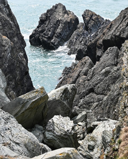
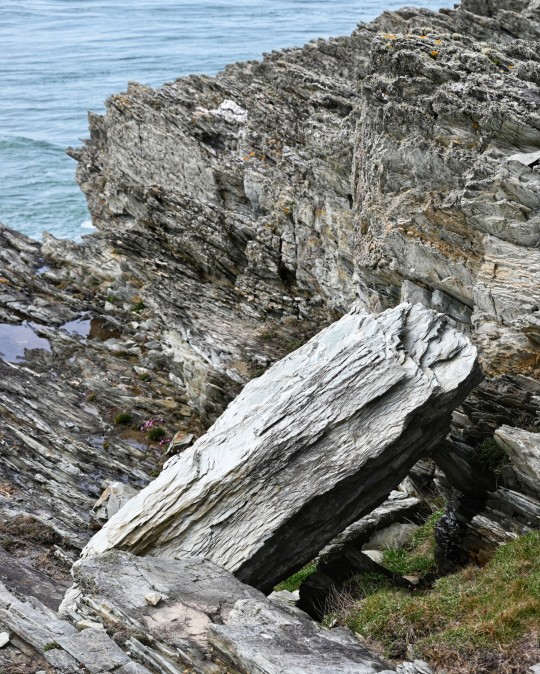
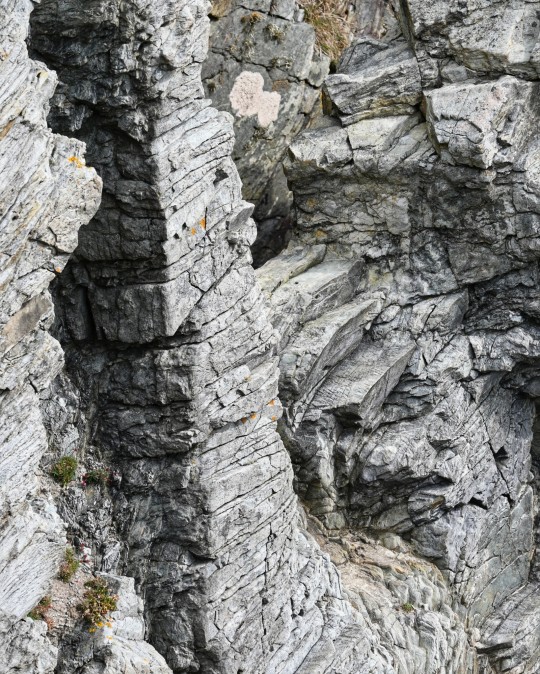
Ynys y Fydlyn Iron Age Promontory Fort, Anglesey, Wales
The last image shows one of the roundhouse sockets on the headland.
#ice age#stone age#bronze age#copper age#iron age#neolithic#mesolithic#calcholithic#paleolithic#prehistoric#prehistory#promontory fort#hillfort#settlement#landscape#outdoors#wild places
148 notes
·
View notes
Text
Quick series of "Aloy climbed on top of stuff to take in the sunlit view."
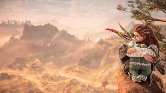
Old Highway west of the Base.

Plainsong viewed from the Promontory.

View towards Embassy ground fro the Barren Light Fort.
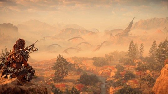
Same Horus, closer angle (love me a good Horus photo).
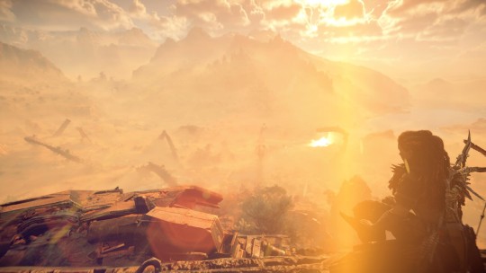
Top of said Horus.
9 notes
·
View notes
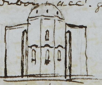
Text
Thursday 25 June 1840
8 ¼
11 5/..
much bit – bad night – heated in my chelat – obliged to throw it off – did not sleep till five – fine but dullish morning and windy – breakfast over at 11 10/.. then wrote all but the first 6 lines of p.221 till now 12 10/.. the horses have been come about ½ hour but no guide – message before 9 this morning to say the horses could not be here till 1 – difficult to get them – we did very well yesterday – but we must have a guide if possible – R14 2/3° and F65° now at 12 ¼ in my bedroom – read over account of valley d’Anténi Dubois iii. p. 210 et seq. till ¼ after 1 when the guide came – several little girthing etc. arrangements – A- and myself and George and our Cossack and the Georgian guide fine horses, and a mounted Cossack besides – 6 of us – off at 1 35/.. – fine day but windy – at the river (Kour) in 10 minutes – broad dry, gravelly (small bouldery) bed, and deep rapid stream just at the foot of the hills on its right bank – unsaddled our horses held them in halters and swam them after us – over in 2 or 3 minutes in 2 long tree-like boats, but only the ends scooped out of trees – the rest 2 boards on a side and perhaps a tree bottom – two board huts on the other side and people always ready at this ferry – part of culée of one old stone bridge – over at 2 10/.. resaddled and en route in about 10 minutes or ¼ hour – we immediately turned right along the foot of the hill – evidently not a high road even for these parts – it was soon evident our guide given us by the maître de police did not know the way – had never been at Aténi – he had to inquire and we went a little out of our way – A- first we passed the Scierie of the Eristav – A- then turned up a hill at 4 to look at a little old stone (oblong, 2 gable ends) church – then forwards and alighted at 4 23/.. at the village (sâcles and 2 good little church and one old oblong 2 gable ended church) d’Aténi and set off to mount the hill to old fort finely placed on little plateau of rock high above – this not the monastery de Sion – remounted – rode thro’ the village and wound round the rock along a narrow path – the part cut out of the rock only about 5ft. wide and of this about 80 to 100 yards was water course and we rode thro’ the water alighted at the monastery de Sion at 4 50/.. finely situated on on bold promontory of rock right across the valley leaving room only for the clear, beautiful little stream (the Tana – excellent trout stream) – charming little green bottom of valley orchards and vineyards and gardens – the most picturesque little valley we have yet seen in the Caucasus – 2 green branches turn off a little beyond the monastery – the Tana runs along that to the right (as we look up the stream) and runs about 10v. farther said our guide rode thro’ hedges and bushes of jasmine, pomegranate, yellow honeysuckle, sweet gall, privet in flower and particularly pretty along the banks of the river here and there – beautiful narrow deep winding valley – the church would easily be put into repair tho’ now merely used to 1 house sheep and cattle –
Dubois and account good
the roof flags thick and cut with one lapping edge, like the edge of a tile, and one lapped over another – the river winds beautifully beyond the church in narrow gorge, all the selvage garden and vineyard and green grass – beautifully picture of from St. Sion at 6 40/.. – at the Scierie in ½ hour – alighted for a minute or 2 – wood cottages and saw mill
only 2 saws in it, and wood house neat for the Eristav himself when he is here – trotted briskly – at the ferry at 7 50/.. – sometime in arranging – unsaddled the horses and let them swim by themselves to the other side, and sent someone, or somehow somebody did catch them and prevent their trotting away home – we [?] over in 2 minutes at 8 3/.. and home at 8 18/.. the tea over at 9 55/.. and had Domna till 10 ¼ - very fine day
East front but only a yard wide walk between church and low parapet wall over the [?] .:. could not see well –
north front standing close under it – south front the same 2 arcades one on each side the door
this sketch copied from rough book at Koutais no! from loose paper Sunday 5 July 1840, and note quite sure about the top part – could not see the dome neither one sketch or other – too close – very little space about the church except from the west where is the court and entrance – had not time did not think to the west front
4 notes
·
View notes
Text
Thursday 25 June 1840
[up at] 8 1/4
[to bed at] 11 5/..
much bit – bad night – heated in my chelat – obliged to throw it off – did not sleep till five – fine but dullish morning and windy – breakfast over at 11 10/.. then wrote all but the first 6 lines of page 221 till now 12 10/.. the horses have been come about 1/2 hour but no guide – message before 9 this morning to say the horses could not be here till 1 – difficult to get them – we did very well yesterday – but we must have a guide if possible – Reaumur 14 2/3° and Fahrenheit 65° now at 12 1/4 in my bedroom – read over account of valley d’Aténi Dubois iii page 210 et sequentes till 1/4 after 1 when the guide came – several little girthing etc. arrangements – Ann and myself and George and our Cossack and the Georgian guide five horses, and a mounted Cossack besides – 6 of us – off at 1 35/.. – fine day but windy – at the river (Kour) in 10 minutes – broad dry, gravelly (small boulder) bed, and deep rapid stream just at the foot of the hills on its right bank – unsaddled our horses held them in halters and swam them after us – over in 2 or 3 minutes in 2 long tree-like boats but only the ends scooped out of trees – the rest 2 boards on a side and perhaps a tree bottom – two board huts on the other side and people always ready at this ferry – part of culée of one old stone bridge – over at 2 10/.. resaddled and en route in about 10 minutes or 1/4 hour – we immediately turned right along the foot of the hill – evidently not a high road even for these parts – it was soon evident our guide given us by the maïtre /maître/ de police did not know the way – had never been at Aténi – he had to inquire and we went a little out of our way – Ann first – we passed the scierie of the Eristav – Ann then turned up a hill at 4 to look at a little old stone (oblong, 2 gable ends) church – then forwards and alighted at 4 23/.. at the village (sâcles and 2 good little churches and one old oblong 2 gable ended church) d’Aténi and set off to mount the hill to old fort finely placed on little plateau of rock high above – this not the monastery de Sion – remounted – rode thro’ the village and wound round the rock along a narrow path – the part cut out of the rock only about 5 feet wide and of this about 80 to 100 yards was water course and we rode thro’ the water alighted at the monastery de Sion at 4 50/.. finely situated on on /AL’s repetition/ bold promontory of rock right across the valley leaving room only for the clear, beautiful little stream (the Tana – excellent trout stream) – charming little green bottom of valley orchards and vineyards and gardens – the most picturesque little valley we have yet seen in the Caucasus – 2 green branches turn off a little beyond the monastery – the Tana runs along that to the right (as we look up the stream) and runs about 10 versts farther said our guide ride thro’ hedges and bushes of jasmin, pomegranate, yellow honeysuckle, sweet gale, privet in flower and particularly picturesque along the banks of the river here and there – beautiful narrow deep winding valley – the church would easily be put into repair tho’ now merely used to house sheep and cattle – Dubois’ account good
East front
but only a yard wide walk between church and low parapet wall over the precipice therefore could not see well –
[added on] Sunday 5 July

north front standing close under it – south front the same 2 arcades one on each side the door
this sketch copied from rough book at Koutais no! from loose paper Sunday 5 July not quite sure about the top part – could not see the dome neither one sketch or other – too close – very little space about the church except from the west where it the court and entrance – had not time did not think to the west front –
the roof flags thick and cut with one lapping edge, like the edge of a tile, and one lapped over another – the river winds beautifully beyond the church in narrow gorge, all the selvage garden and vineyard and green grass – beautifully picturesque off from St. Sion at 6 40/.. – at the scierie in 1/2 hour – alighted for a minute or 2 – wood cottages and saw mill, only 2 saws in it, and wood house neat for the Eristav himself when he is here – trotted briskly – at the ferry at 7 50/.. – some time in arranging – unsaddled the horses and let them swim by themselves to the other side, and sent someone, or somehow somebody did catch them and prevented their trotting away home – we then over in 2 minutes at 8 3/.. and home at 8 18/.. tea over at 9 55/.. and had Domna till 10 1/4 – very fine day –
WYAS page: SH:7/ML/E/24/0134
#anne lister#ann walker#anne lister code breaker#gentleman jack#diary1840unannotated#russianempire1840#georgia1840
3 notes
·
View notes
Text
Old Town of Galle and its Fortifications
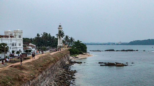
Nestled along the sun-kissed shores of Sri Lanka lies the enchanting Old Town of Galle, a UNESCO World Heritage Site renowned for its captivating blend of history, culture, and colonial charm. Step back in time as we wander through the cobblestone streets and imposing ramparts of Galle Fort, where every corner tells a story of centuries past.
Galle Fort stands as a testament to Sri Lanka's rich and diverse heritage, bearing witness to centuries of colonial rule and maritime trade. Originally built by the Portuguese in the 16th century and later fortified by the Dutch, the fortifications are a fascinating fusion of European architectural styles and local craftsmanship. Wander through the labyrinthine streets lined with colonial-era buildings, each one bearing the scars of time and history.
Perched majestically atop the rocky promontory, Galle Fort served as a strategic stronghold against maritime invaders for centuries. Its imposing ramparts and bastions offer sweeping views of the Indian Ocean, providing a glimpse into the fort's storied past as a vital trading hub in the spice trade route. Today, the fortifications stand as silent sentinels, watching over the bustling port city of Galle with timeless grace.
Step into the heart of Galle Fort and discover a vibrant tapestry of cultures and traditions woven together over centuries of exchange. From the imposing Dutch Reformed Church to the intricate carvings of the Old Dutch Hospital, the fort's architectural treasures reflect the diverse influences that have shaped Sri Lanka's cultural landscape. Explore the bustling markets, where the aromas of exotic spices mingle with the sounds of bustling commerce, and immerse yourself in the vibrant pulse of daily life.
As a UNESCO World Heritage Site, Galle Fort is not just a relic of the past but a living testament to Sri Lanka's enduring heritage. Efforts to preserve and restore the fortifications ensure that future generations can continue to marvel at its beauty and significance. Visitors are invited to wander through the historic streets, explore the museums and galleries, and soak in the timeless atmosphere of this unique cultural gem.
Whether you're a history buff, a culture enthusiast, or simply seeking a moment of tranquility amidst the beauty of the past, Galle Fort offers an unforgettable journey through time and heritage. Lose yourself in the narrow alleyways, stroll along the sun-drenched ramparts, and let the echoes of centuries past guide you on a voyage of discovery through one of Sri Lanka's most cherished treasures.🏰🌊 🇱🇰
1 note
·
View note
Text
What are the main attractions or landmarks in Birla RR Nagar?

Exploring the Enchanting Charms of Birla RR Nagar
Birla RR Nagar, nestled in the heart of [insert location if available], is a hidden gem waiting to be discovered by avid explorers and curious travelers alike. Steeped in history, culture, and natural beauty, this quaint neighborhood boasts an array of captivating attractions and landmarks that offer a glimpse into its rich heritage and vibrant character. Join us on a virtual journey as we unravel the enchanting charms of Birla RR Nagar and explore its most noteworthy points of interest.
Birla Institute of Technology and Science (BITS):
Situated at the heart of Birla RR Nagar, BITS stands as a beacon of academic excellence and innovation. This esteemed educational institution is renowned for its rigorous academic programs, world-class faculty, and state-of-the-art facilities. Visitors can stroll around the campus, admiring its architectural marvels and lush greenery, or attend one of the many cultural events and workshops throughout the year.
Birla Park:
Nature enthusiasts and fitness lovers will find solace in the serene surroundings of Birla Park. Spanning acres of verdant landscapes, this sprawling park offers a tranquil retreat from the hustle and bustle of city life. Visitors can enjoy leisurely walks along winding pathways, indulge in outdoor picnics with family and friends, or partake in recreational activities such as yoga sessions and outdoor sports. The park’s verdant lawns, vibrant floral displays, and tranquil water bodies make it a picture-perfect spot for relaxation and rejuvenation.
Birla Temple:
As a testament to the neighborhood’s cultural heritage and spiritual significance, the Birla Temple stands tall as a majestic symbol of devotion and faith. This architectural marvel, adorned with intricate carvings and ornate embellishments, is dedicated to various Hindu deities and serves as a sacred sanctuary for devotees and pilgrims. Visitors can marvel at the temple’s awe-inspiring architecture, immerse themselves in prayer and meditation, or soak in the tranquil ambiance of this divine abode.
Birla Museum:
Delve into the rich tapestry of Birla RR Nagar’s history and heritage at the Birla Museum. Housed within a charming heritage building, this museum showcases a diverse collection of artifacts, artworks, and memorabilia that chronicle the neighborhood’s evolution. From ancient artifacts and archaeological finds to vintage photographs and historical documents, the museum offers a fascinating glimpse into the cultural, social, and economic fabric of Birla RR Nagar.
Birla Lake:
Nestled amidst lush greenery and rolling hills, Birla Lake is a picturesque oasis that beckons travelers seeking tranquility and natural beauty. This scenic reservoir, enveloped by verdant forests and teeming with avian life, is a haven for birdwatchers, nature lovers, and photography enthusiasts. Visitors can embark on leisurely boat rides, enjoy serene lakeside picnics, or bask in the breathtaking vistas of the surrounding landscape.
Birla Market:
Dive into the vibrant tapestry of local culture and commerce at Birla Market. This bustling marketplace, teeming with activity and energy, offers a kaleidoscopic array of goods, wares, and delicacies to tantalize the senses. From fresh produce and spices to handicrafts and souvenirs, the market is a treasure trove of eclectic finds waiting to be discovered. Visitors can meander through narrow alleys, haggle with friendly vendors, and sample delectable street food delicacies, immersing themselves in the vibrant sights, sounds, and flavors of Birla RR Nagar.
Birla Fort:
Perched atop a rocky promontory overlooking the neighborhood, Birla Fort is a timeless testament to the region’s storied past and architectural grandeur. With its towering ramparts and imposing battlements, this ancient fortress offers panoramic views of the surrounding landscape and serves as a mesmerizing backdrop for history enthusiasts and photography enthusiasts alike. Visitors can explore the fort’s labyrinthine corridors, marvel at its ancient artifacts and inscriptions, or soak in the majestic ambiance of this historic landmark.
Conclusion
In conclusion, Birla RR Nagar is a veritable treasure trove of cultural, historical, and natural wonders, offering many experiences to captivate and inspire visitors of all ages. Whether you’re a history buff, a nature lover, or a curious traveler searching for adventure, this charming neighborhood has something for everyone to enjoy. So come, embark on a journey of discovery, and let the enchanting charms of Birla RR Nagar leave an indelible mark on your heart and soul.
Why do you need to select Birla RR Nagar in Bangalore?
Birla RR Nagar in Bangalore is a testament to a luxurious dwelling in the heart of Bangalore. With number 2 and three-bedroom apartments designed to cater to various preferences, the venture offers a perfect combination of comfort, aesthetics, and present-day facilities. While the price of residing in Birla RR Nagar in Bangalore reflects the top-rate nature of the improvement, the investment potential and the first-rate existence it guarantees make it a compelling preference for the ones seeking to make extended-term funding in Bangalorean’s actual property marketplace.
Related Links
Birla Ojasvi RR Nagar
Birla RR Nagar
Lodha Bannerghatta
Related Articles
Birla Advaya RR Nagar
0 notes
Last Seen Blogs

atomwater
リアル感が好き

sheinretech
Untitled

jsonjn
take me away;

simsmodu
SIMS MODU 모두

redstonebug
mostly mcyt art whee