#.map
Text
Horizon: Zero Dawn Real Life Map (Maps) (Real Filming Locations)

Here’s my work in progress real life map of the video game series of @playstation @guerrillagames #HorizonZeroDawn. This map includes custom made map icons that I’ve made using @adobe #AdobeCreativeCloud and includes all of the locations including the recent games which I’m yet to play. Please let me know what you think by leaving a comment.
#warrenwoodhouse#gaming#maps#fan made#fanmade#real life#real filming locations#realfilminglocations#map#google my maps#googlemaps#google maps#.map#2024#horizon zero dawn#horizon forbidden west#horizonzerodawn#horizonforbiddenwest#forbidden west#horizon#guerrilla games#playstation#psshare#psblog#psn:warren-woodhouse#horizon-0-dawn#horizon 0 dawn
37 notes
·
View notes
Text

Map of Naboo
#star wars#sw#naboo#nabooro#.map#// to be clear i made this. its why its been a while lol it took a bit
50 notes
·
View notes
Text
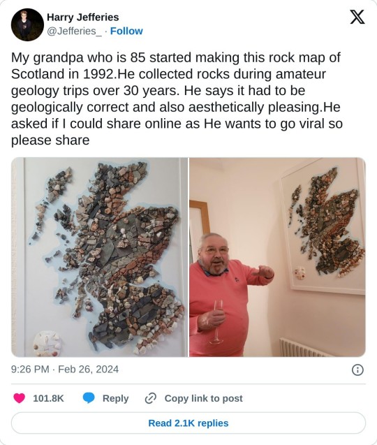
#geology#scotland#i haven't worked in geology in 30 years#but it's still dangerous to let me drive when the geology is interesting#@ayeforscotland#but i am still a cartographer#and this is a way cool map
52K notes
·
View notes
Text
the extent that i would be at emo night at sneaky dees every single weekend is crazy. you would think i was canadian.
42K notes
·
View notes
Photo
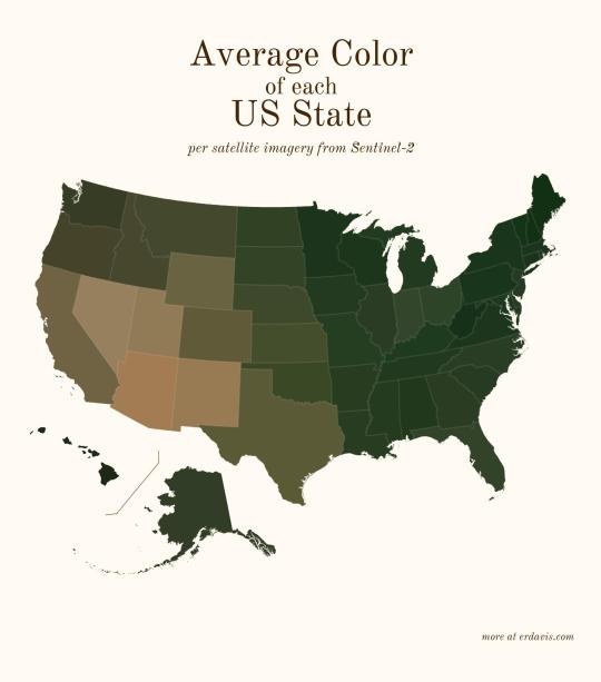
Average color of US states based on satellite imaging.
86K notes
·
View notes
Text
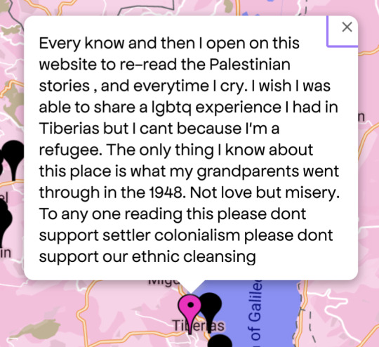
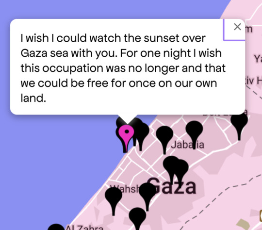


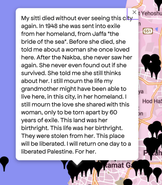

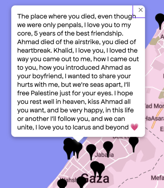
Queering the Map in Gaza and the West Bank
#these screenshots are all from queering the map#absolutely fucking heartbreaking#free palestine#palestine#queer rights#pinkwashing#gaza#genocide#lgbtq community
24K notes
·
View notes
Text
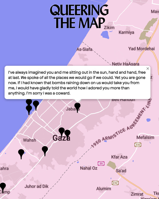
queerness under apartheid
#free palestine#queering the map#i think of this everytime someone opens their stupid mouth to say 'but palestinians are homophobic' as if that justifies ethnic cleansing#it makes me so angry and so heartbroken
43K notes
·
View notes
Text
I just want to remind everyone that it is your civic duty to jailbreak your Nintendo consoles and pirate every Nintendo property until the heat death of the universe.
#I swear if the map from “Team Fabulous 2” ends up getting lost I'm gonna fucking kick a Nintendo employee in the stomach#nintendo#steam#garry's mod#gmod#piracy
15K notes
·
View notes
Text
Two types of people on Queering the map:


34K notes
·
View notes
Text
Reading a book on sea monsters on ancient maps and I thought this was such a funny way to put it. They couldn’t even afford sea monsters :///
16K notes
·
View notes
Text
Fallout Vaults Real Life Map (Maps) (Real Filming Locations)
Map by @warrenwoodhouse. Here is my custom made real life map featuring all of the vaults from the entire @fallout franchise so far. More will be added over time, so check back frequently. Please let me know what you think in the comments and please make sure to add the hashtag #warrenwoodhouse when sharing or reblogging to your own blogs and websites. CLICK HERE to see the rest of the Fallout maps that I’ve created, including the ones that feature every single location from the entire franchise!
#warrenwoodhouse#gaming#2024#google maps#google my maps#googlemaps#map#maps#real life#fallout#fallout: new vegas#fallout 3#fallout 4#fallout tactics#fallout tv series#fallout shelter#fallout maps#fallout 2#fallout 76#fan made#fanmade#.map#realfilminglocations
20 notes
·
View notes
Text
Somebody (me, it's me) forgot to mark Naboo's canon cities on the map and really doesn't want to rearrange things to put more labels in on this day:
Note: some of these are no longer Canon or just in Legends or... whatever. They're all there though maybe not where they're said to be on Wookieepedia. It's fine.
Chafala - Central Danank
Dee'ja Peak - in the valleys of the mountains in Shisén, roughly between Bisemb and Jémid
Ferentina - north Arind
Harte Secur - west coast of Halân
Kaadara - north coast of Danank, not too far from Theed
Keren - the city on the map in Deetân currently named Cankab. I will amend that later
Kwilaan - south Nirerd
Moenia - central Arind, maybe a large-ish city at the base of the hills
New Centrif - Halân
Oxon City - central Danank
Parrlay - Halân
Pontel - Arind
Port Landien - Arind
Selton - somewhere in Deetân
Spinnaker - north-west Danank
Vis - Halân
Gungan cities:
Jan-Gwa City: Northern Ojian
Otoh Gunga: Lake Paonga, north of Theed
Otoh Jahai: Central Ojian
Otoh Langua: South Nirerd
Otoh Mandassa: Danank
Otoh Raban: Arind
Otoh Sancture: North Deetân
Otoh Urs: the only Gungan city on Halân
Rellias: Off the west coast of Nirerd
Shoril: Shisén
Spearhead: Danank
Umberbool City: North Arind
15 notes
·
View notes
Text
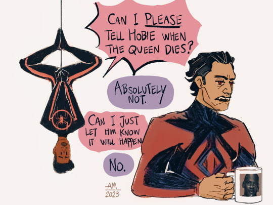
While listening to Hobie's contemporary records an incredibly vital question comes up… does he know?
#into the spider verse#across the spider verse#across the spider verse fanart#miles morales#hobie brown#spider punk#gwen stacy#spider gwen#miguel o'hara#mine#fanart#marvel#hoping miguel doesn't look too pale in the second image i just threw a gradient map on my sketch bc im exhausted#edit 14 Jun recolored it entirely
42K notes
·
View notes
Text
Hey All,
I've been away for some time, as we've been working really hard on something quite exciting:
let me present to you the world's first ever global ocean drainage basin map that shows all permanent and temporary water flows on the planet.

This is quite big news, as far as I know this has never been done before. There are hundreds of hours of work in it (with the data + manual work as well) and it's quite a relief that they are all finished now.
But what is an ocean drainage basin map, I hear most of you asking? A couple of years ago I tried to find a map that shows which ocean does each of the world's rivers end up in. I was a bit surprised to see there is no map like that, so I just decided I'll make it myself - as usual :) Well, after realizing all the technical difficulties, I wasn't so surprised any more that it didn't exist. So yeah, it was quite a challenge but I am very happy with the result.
In addition to the global map I've created a set of 43 maps for different countries, states and continents, four versions for each: maps with white and black background, and a version for both with coloured oceans (aka polygons). Here's the global map with polygons:
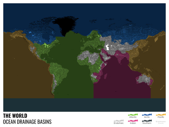
I know from experience that maps can be great conversation starters, and I aim to make maps that are visually striking and can effectively deliver a message. With these ocean drainage basin maps the most important part was to make them easily understandable, so after you have seen one, the others all become effortless to interpret as well. Let me know how I did, I really appreciate any and all kinds of feedback.
Here are a few more from the set, I hope you too learn something new from them. I certainly did, and I am a geographer.
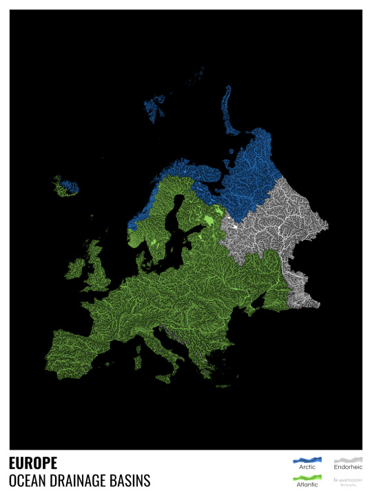
The greatest surprise with Europe is that its biggest river is all grey, as the Volga flows into the Caspian sea, therefore its basin counts as endorheic.
An endorheic basin is one which never reaches the ocean, mostly because it dries out in desert areas or ends up in lakes with no outflow. The biggest endorheic basin is the Caspian’s, but the area of the Great Basin in the US is also a good example of endorheic basins.
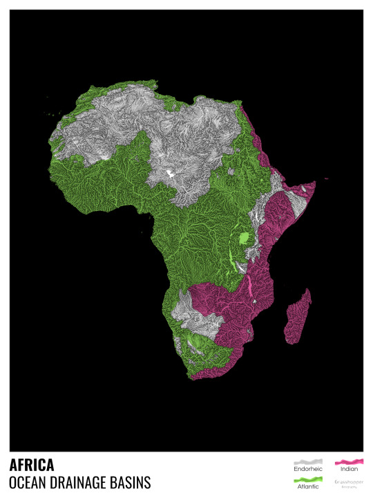
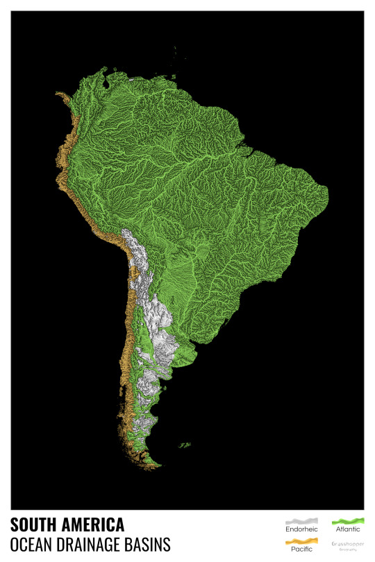
I love how the green of the Atlantic Ocean tangles together in the middle.
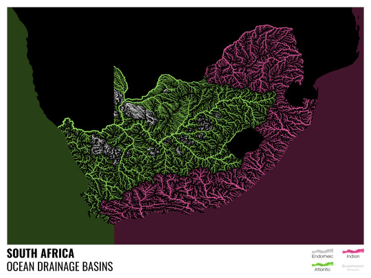
No, the dividing line is not at Cape Town, unfortunately.
I know these two colours weren’t the best choice for colourblind people and I sincerely apologize for that. I’ve been planning to make colourblind-friendly versions of my maps for ages now – still not sure when I get there, but I want you to know that it’s just moved up on my todo-list. A lot further up.
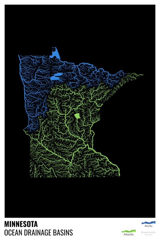
Minnesota is quite crazy with all that blue, right? Some other US states that are equally mind-blowing: North Dakota, New Mexico, Colorado, Wyoming. You can check them all out here.
Yes, most of the Peruvian waters drain into the Atlantic Ocean. Here are the maps of Peru, if you want to take a closer look.
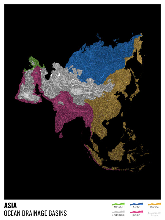
Asia is amazingly colourful with lots of endorheic basins in the middle areas: deserts, the Himalayas and the Caspian sea are to blame. Also note how the Indonesian islands of Java and Sumatra are divided.
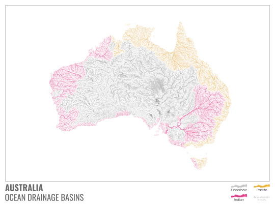
I mentioned earlier that I also made white versions of all maps. Here’s Australia with its vast deserts. If you're wondering about the weird lines in the middle: that’s the Simpson desert with its famous parallel sand dunes.
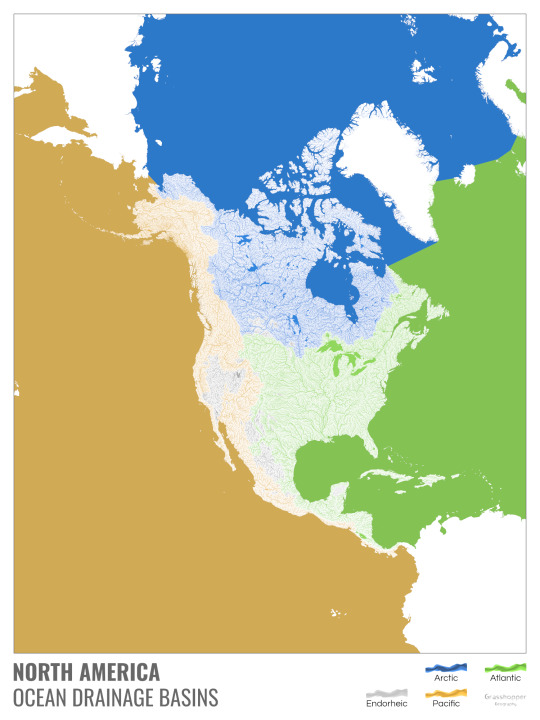
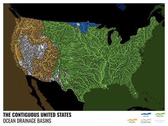
North America with white background and colourful oceans looks pretty neat, I think.

Finally, I made the drainage basin maps of the individual oceans: The Atlantic, the Arctic, the Indian and the Pacific. The Arctic is my favourite one.
I really hope you like my new maps, and that they will become as popular as my river basin maps. Those have already helped dozens of environmental NGOs to illustrate their important messages all around the world. It would be nice if these maps too could find their purpose.
#maps reimagined#geography#cartography#maps#my art#rivers of the world#ocean drainage basins#ocean maps#river maps
16K notes
·
View notes
Photo

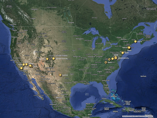
U.S. Counties where the African American population is 25% or more
18K notes
·
View notes
Text
#robin#poll#tim drake#dick grayson#jason todd#stephanie brown#damian wayne#carrie kelley#maps mizoguchi#batfam
10K notes
·
View notes
Last Seen Blogs

1azam
Boss

ndostairlyrium
Oak Leaves and Small Cakes

victoria-duan
无标题

puddle-plort
Disabled Freak

gawin88ad
Gawin88