#Loring Greenway
Photo

Snoopy on The Loring Greenway bridge over Lyndale Avenue in Minneapolis in January 2024.
66 notes
·
View notes
Text
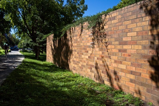
Brick, Bike, and Bird.
Along the Loring Greenway, Minneapolis.
#minneapolis#minnesota#twin cities#loring greenway#photography#photographers on tumblr#original photographers#canon 6d
3 notes
·
View notes
Text
Vault 29 is mentioned in Fallout 76. It was meant to appear in Van Buren, the canceled Fallout 3 project by Black Isle Studios.
"At this rate, I'm going to end up shipped out to the west coast to work as a janitor in 29 with a bunch of obnoxious rich teenagers or something."
fuck yes. smoking gun. wait. wait
At one point Greenway explained his plans for Vault 29 to Diana, the human brain connected to a powerful computer, to see what her opinion would be. He was quite surprised when Diana was appalled at the idea. She said that, although the idea had merit, she found it to be morally objectionable on several levels. She recommended that the plan be scrapped. When Derek refused to do so, Diana took it upon herself to become involved with the project without his knowledge.
fuck. holy fuck. holy fuck this is the twin mothers vault. they namedropped Diana Stone's lair and invoke its lore. this....... changes things
15 notes
·
View notes
Text
Tethered to the Night
Skip the golf balls, go straight
to hail
the size of tennis balls.
No bounce. As if some kind
of inferior hawk, a kite
flies on the other side
of the highway overpass
before the storm.
Heavier than air, branches
everywhere, deeper puddles
than I can remember
block access to the trail
I want most.
I hear the hotel hum
a tune I don’t recognize
as I pass behind it
on the Loring Greenway.
Three…
View On WordPress
0 notes
Text
Mr. Handyman of Fairfax and Eastern Loudoun Counties
2944 Hunter Mill Rd Suite 204, Oakton, VA 22124, United States
703-962-1202
https://www.mrhandyman.com/fairfax-eastern-loudon-counties/
Is your home in desperate need of repairs and regular maintenance? Or maybe you have improvement projects in mind to make your home better suited to your unique needs?
Whatever services are needed to transform your home into your ideal living space, the reliable service professionals at Mr. Handyman of Fairfax and Eastern Loudoun Counties are here to help! There’s no need to call multiple contractors to take care of all the tasks that need to be done around your house when we can take care of every last thing quickly and efficiently.
As a locally owned and operated business, we take pride in serving the communities we are a part of with high-quality workmanship and outstanding customer service. We provide comprehensive handyman services in Aldie, Alexandria, Ashburn, Centreville, Chantilly, Dulles, Dunn Loring, Fairfax, Great Falls, Greenway, Hamilton, Herndon, Leesburg, Lincoln, Lovettsville, McLean, West Mclean, Merrifield, Middleburg, Oakton, Paeonian Springs, Philomont, Purcellville, Reston, Round Hill, Sterling, Vienna, Washington, Waterford, and other nearby areas.
Interior handyman services include furniture assembly, drywall repair and finishing, dryer vent cleaning, water heater insulation, bathroom and kitchen remodeling, custom carpentry, ceiling repair, painting crown molding and other trim, light fixture installation and repair, fan installation, flooring installation, tile installation, garage organization, garage door opener installation, baby proofing, TV wall mount installation, cabinet and countertop installation, fire and flood protection, furniture painting and sanding, aging in place accommodations, weatherproofing, and much more.
Exterior handyman services include deck and patio repair and construction, fence repair and installation, wood rot repair, window and door repair and installation, pressure washing, gutter cleaning, painting and staining trim and decks, weather preparedness, soffit and fascia repair, siding repair, and much more.
Commercial handyman services include professional maintenance and repair services for hospitality, food service, retail, small business and large corporate offices, municipal and state government buildings, financial institutions, manufacturing and fabrication plants, healthcare facilities, and much more.
If you’re in need of experienced help with maintenance, repairs, and improvements, Mr. Handyman of Fairfax and Eastern Loudoun Counties is your best choice for local, dependable handyman services.
Call 703-962-1202 today, or fill out the request service form on our website, and we’ll show you what we can do to enhance your home and make your life easier!
#handyman Fairfax#Fairfax handyman service#handyman service Fairfax#Fairfax handyman#handyman services
1 note
·
View note
Photo
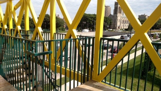
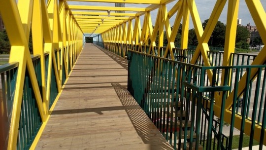
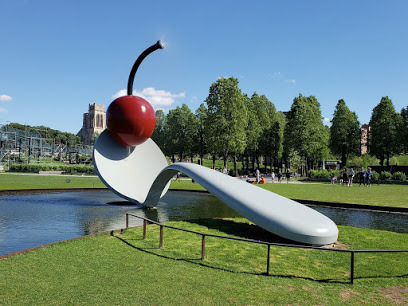
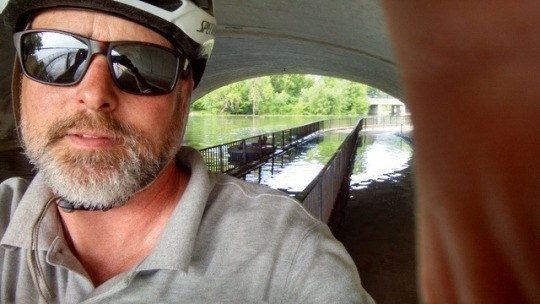
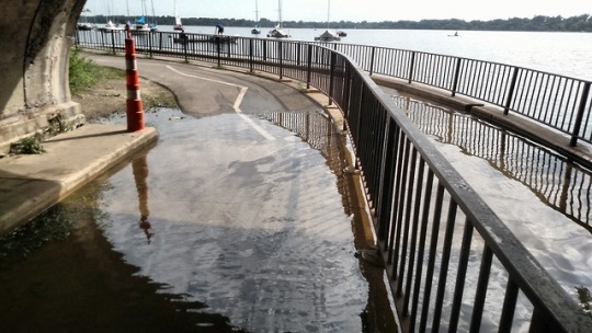
Scenes from my bike commute
1 and 2 - the Loring Greenway pedestrian bridge over I-94 by downtown Minneapolis. It was repainted last summer and looks very nice.
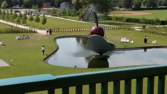
3 - The Spoon Bridge and Cherry at the Walker Art Center.
4 - The Spoon Bridge again, but not my picture. This one is a better angle though.
5 and 6 - The tunnel under Lake Street, between Lake of the Isles and Bde Maka Ska. The channel connecting the two lakes is flooded, spilling over, onto the pedestrian and bike paths. My bike has fenders so I rode through it and didn’t get splashed. A dead fish had washed onto the bike path.
The weather sucked. Hot and humid. I took it easy but still was wiped out when I got home. Everyone else in this house is sick. In my weakened state, a horrible cough, runny nose, and headache can only be hours away :(
Today in the office I got close to losing my mind. A woman sitting near me had to reset her password. The system forces password resets every 90 days. Meaning, she’s done this before, probably twice so far this year.
Yet she couldn’t figure it out. She got locked out of her computer. I heard her on the phone to our tech support people. “Wait, how many characters? Upper and lower case? Seriously? Do I HAVE to use a special character? I can’t think of what letters to use. I’m locked out again. Will you do that reset again?”
This is exactly the person who would use PASSWORD or 12345678 if those weren’t already prohibited.
45 notes
·
View notes
Text
Amazon LotR Map Analysis
Unfortunately the LotR fandom, Silmarillion fandom, and general Tolkien fandom on Tumblr has seemed either entirely uninterested in this show, or openly hostile to it ever since its announcement. This, to me, is a shame, since the involvement of the Tolkien Estate, together with the learning experiences of the critically panned Hobbit trilogy and the immense budget given to this show all point to a series of good quality and impressive visuals. At the very worst case, we will get to see more Middle-earth on screen, and I for one am thrilled at that prospect.
Anyway, today marked the end of the long and emotionally fraught series of maps released by the “Lord of the Rings on Prime” account on their Twitter, Instagram, and Facebook. Through the whole process, many theories have been going around as to the meanings of the various maps, speculations on the inclusions of certain names, and so forth. Now that we have reached the apparent end of the map releases (since the Ring verse they’ve been accompanied by has been completed), it seems a good time for me to analyze the map in its final form, as well as any pertinent details from the previous incarnations that might appear striking. I’ll break the map down into sections to make it easier to go through all the details.
Without further ado, let’s begin!
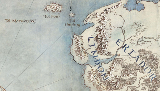
First thing I noticed was the addition of the Western Isles, Tol Morwen, Tol Fuin, and Tol Himling. Some brief lore discussion:
Tol Morwen: This island marks the grave of Túrin Turambar, Niënor Níniel, and Morwen Edhelwen. The Stone of the Hapless, or the Talbor (in Taliska) was the grave marker made for them by the people of Haleth, and was prophesied by Glirhuin the bard to remain standing even if the waves drowned the land, as indeed after befell.
Tol Fuin: This island is the remains of the pine clad heights of Dorthonion, where the people of Bëor dwelt in their land of Ladros. The most interesting facet of its inclusion on this map is that it only appears in The Unfinished Tales, and is not part of any map published along with Lord of the Rings or the Hobbit. This has some interesting implications, as we will discuss later.
Tol Himling: This island is the height where Maedhros had his city and fortress of Himring in the First Age, which was destroyed by Morgoth during their long war. It remains above the sea after the flooding caused by the War of Wrath.
The rest of this section is nothing too new, but there is one minor feature that caught my eye. The hills next to the names Forlindon and Harlindon were not present on any previous version of the map, nor are they present in any published Tolkien map. As we will see later when we examine the land where Gondor will come to be, he coastline is changed there. Both of these are connected, I think, to the fact that this map is in the Second Age, before the Downfall of Númenor. In this time the world was flat, but after the Cataclysm, the flooding caused by the destruction of the island led to great changes in the coastlines of Middle-earth, and I think these hills reflect the prior state of the coast.
Nenuil is included, which may indicate the possible presence of the native men of Eriador, who first met the Númenóreans in the hills to the north of the lake.
The inclusion of the names Lindon, Harlindon, Forlindon, and Mithlond all point to the inclusion of Gil-galad’s kingdom of Lindon in the series, which was the last and largest High-Elven kingdom in the Second Age.
The Ered Luin, Lhûn and Baranduin (Brandywine) are also named, but this is most likely just an indicator that the general region of Eriador will be a setting for the show.

This is a very exciting portion of the map! A lot of information is conveyed by the names here, so let’s break it down.
Eregion was the Noldorin realm founded by Galadriel and Celebrimbor, where the Rings of Power were eventually forged. Ost-in-Edhil was the capital city. Curiously, on this map, Ost-in-Edhil is moved from it’s canon location and placed where the city of Tharbad is meant to be. This may simply be a choice on the part of the showrunners to give Ost-in-Edhil a more interesting location by placing it next to the marshes of Nîn-in-Eilph, the Swanfleet, but at this point we can’t know for sure. Regardless, the inclusion of these names, including the Glanduin and Gwathló rivers, points very strongly to the setting of the show being during or before the forging of the Rings of Power in SA 1600, as Eregion was destroyed soon afterwards.
The Bruinen and the Mitheithel are named, but pointedly Imladris is absent from the location where it was on the previous iterations of the map. This indicates also that the show takes place during or before the forging of the Rings of Power, since Imladris was founded in the following war.
Khazad-dûm is also named, as well as the three mountains Fanhuidhol, Celebdil, and Caradhras which rise above it. Together with the Celebrant river and the valley of Nanduhirion (Azanulbizar in Khûzdul), these names suggest the inclusion of the Dwarves of Moria, or Hadhodhrond as it was called by the Elves in those days. The name Lórinand is also given, which was the name of the kingdom of Silvan Elves ruled by the Sindarin King Amdír. There are excellent meta-analyses of the source texts in existence that show his friendship with the Dwarves of Hadhodhrond was quite strong, which is strange for a Sindarin Elf.
Ninglor and the Hithaeglir and the Anduin are named, but I cannot see any hints there beyond the simple fact that they were around at that time, although the inclusion of the Ninglor (Gladden) is odd.
The North-South road later called the Greenway is present on this map, which is odd to me. I had always thought the road was built to connect Gondor and Arnor together, but since this is before they were founded, I am unsure why it is included. It ends where Fornost will be one day, but currently it is blank. Will we see a new settlement of Men in this place? Perhaps the center of the native Eriador civilization encountered by the Númenóreans?
Lond Daer is included on this map, which lets us know that the show must take place after SA 750/800 when that haven was created by Aldarion the crown prince of Númenor as a source of lumber and supplies for the fleets.
Speaking of lumber, this brings us to the last feature in the section we can comment on: the forests!! The entirety of Minhiriath (Land Between the Rivers) and Enedwaith (Middle-Folk) is covered in trees, and we learn from The Unfinished Tales that many Men dwelt there at this time, some of whom were wary of the Númenóreans due to their logging of the forest. In fact, in later years, the logging grew so bad that the Men were driven out of the lands and took refuge in the last remnants of the forests, most prominent of which was Eryn Vorn, the Dark Forest, which is also included on this map. Perhaps we will see a settlement of these Men here in the show?
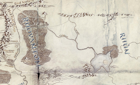
This section was sadly left very unnamed, but there are still plenty of tidbits here!
Gundabad is named, which functioned as the Awakening Place of Durin I, and was considered a sacred place to the Long-beard Dwarves. However, after the War of Wrath, Orcs came fleeing into the northern mountains, and they took it to the Dwarves dismay. Could we see this in the show?
The Men-i-Naugrim, the Old Dwarf Road, is also marked on its way through Mirkwood. However, they add an extension of the road leading all the way to the Iron Hills, which has never been included on any Tolkien map to date. The Long-beards founded their settlement in the Iron Hills in either the First or Second Ages, so I am unsure why it is not labeled here.
Amon Lanc is named on the map, which implies the inclusion of the Silvan Realm of Mirkwood. In the early Second Age, the Silvan Elves of Mirkwood lived across the river from their kin in Lórinand, dwelling about the slopes of Amon Lanc, the Bald Hill, later site of Dol Guldur. Their king was Oropher the father of Thranduil, a Sindarin Elf, who later died in the Last Alliance.
The terrain in this region is interesting in several respects. Firstly, the East Bight in Mirkwood has been filled in, since it was in fact not in existence until the Third Age when it was felled by the Northmen who lived there. Celduin and Carnen are named, but the significance of this is unclear. The most interesting feature of the terrain, however, is the inclusion of a series of forested hills across the Anduin from Fangorn. These occupy the later area of the Brown Lands, and in we learn from Treebeard that this land was once the Gardens of the Entwives, until the war of the Last Alliance when Sauron burned them brown. He says that Men lived near the Entwives and learned agriculture from them. It is unclear if we will see Entwives in the show, or if they are simply presenting a more accurate terrain map for the Second Age.
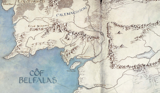
This is another relatively empty map section. However, there are some definite points of interest. Ethir Anduin, Belfalas, Tolfalas, Morthond, Ringló, and Ras Morthil are all geographical areas and features of Gondor, but I am unsure if they have any significance. Ras Morthil is particularly odd, since it is a very obscure place about which we know next to nothing. Drúedain were said to live there, so perhaps we will see them? There is a later unfinished story Tolkien wrote called Tal-Elmar, where the Númenóreans are seen from the perspective of native people living near the mouths of a river in Gondor. Perhaps we will see such a story?
Of particular note is the shape of the coastline. The Anduin does not have a delta, and the coastline is much smaller here than it is on Third Age maps. This is consistent with the lore for the effects of the flooding post-Cataclysm.
Mordor is devoid of names, suggesting that Barad-dûr is not yet built.
The last interesting thing here is the name Côf Belfalas (Bay of Belfalas) which is a name that only occurs in the very very obscure essay by Tolkien titled The Rivers and Beacon Hills of Gondor. It was never published by Christopher Tolkien, and appeared only in the linguistic journal the Vinyar Tengwar. The fact that this name is included here suggests that the rights the show has are far greater than we had previously thought.
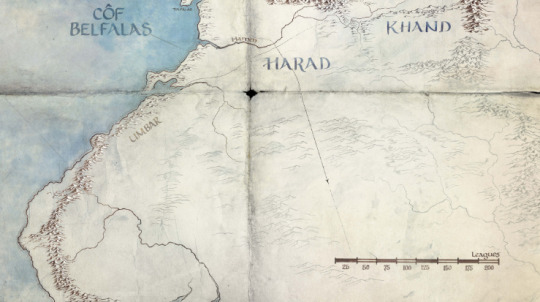
This section is the most new, as well as the least informative. Much terrain has been added, but it is faded quite a lot compared to the rest of the map, and I am unsure what this signifies. Khand is still included, which is very interesting to me. Perhaps we will see these empty areas filled out in a later promotion? So far there have been no new names or made-up named locations, so perhaps they are simply saving them for a later date? Regardless, the possibilities here are virtually endless.
Umbar is interesting in that the city is not marked on the map. We do not have a precise canon date for its founding, but it is odd that it would not be in existence at this time. Even more odd, however, is the fact that a heretofore unknown road is shown leading to its very site, and then off east towards Khand. Perhaps this whole area will be expanded upon at a later date?

This part of the map is only worth commenting on because it is entirely new in terms of the established maps for the Second and Third Ages. In some hasty maps of the First Age, Tolkien shows an eastern range, the Orocarni (Red Mountains) in the east, but it seems that they were further east than these. The identity of these mountains remains a mystery, as we have no new names to speculate with. Perhaps they will also gain some depth.
For the East and South there is the possibility that we will see the Blue Wizards. In Tolkien’s latest notes on the Istari, he said that the Blue Wizards came with Glorfindel in the Second Age around the year 1600, and were instrumental in disrupting Sauron’s plans in the East and South. Perhaps we will see this in the show?

And finally, we have arrived at the most exciting portion of the map: Númenor itself! The island is filled in with all the major names from the Unfinished Tales map, and features all the terrain details we expect. However, its inclusion, along with Tol Fuin from earlier, proves that the show has the rights to The Unfinished Tales, and if the elvish for the Bay of Belfalas is to be believed, it means they have the rights to even more.
So what does all of this mean? Well, based on the dates, there is only one significant global event during the time from SA800-SA1600: the forging of the Rings of Power. All the names for all the places we’d expect to see are present, and many different arenas are included on the map for a truly global showcase of the time. This could include the forging itself, the leadup to it including the political tensions between Galadriel and Celebrimbor and the arrival of Sauron disguised as Annatar, and the War of the Elves and Sauron following after. This war saw the death of Celebrimbor, the creation of Imladris, and the full might of the Númenórean navy.
This will, in my opinion, make for a fun, diverse, and complex show with many different perspectives and characters and races all competing together, as well as the familiar faces and ties to LotR that the show needs to gain popularity with movie fans. Then there’s this:
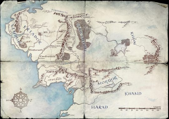
The second-to last map the account released. The inclusion of Arnorian cities like Annuminas and Fornost, as well as Gondorian places like Osgiliath and Minas Anor and Minas Ithil, suggest that the map is teasing the Last Alliance. Perhaps, as has been rumored, the show will be an anthology series, spanning the Forging of the Rings to the Last Alliance. If so, that will be an ambitious project, and one I look forward to with excitement and hope.
#meta#analysis#map#lotronprime#amazonlotr#fandom#lotr#silmarillion#rant#please excuse my absurdly long post#i really wanted to get all of this out.
152 notes
·
View notes
Text

1/3 through Freudian chicken collection / Loring Greenway graffiti / mpls 2021
0 notes
Text
Interactive Public Art Exhibition at Hominy Creek Greenway
By Emma Castleberry
Pagans and Androids. Leaflin Lore Winecoff and Ronin J’in Pilla. Photo by Jason Cannoncro
Friends of Hominy Creek Greenway (FOHCG) presents Hominy Rising, a public art exhibition on display along the greenway from Saturday, October 2, through Sunday, October 10. The exhibition is in celebration of Hominy Creek Greenway’s 10th anniversary. “The exhibition was inspired by the beauty and ecology of the greenway, as well as the community that has formed around its public use,” says FOHCG board president Bryan Tomes. “All of the work is place-based and many of the artists in the show walk the greenway regularly.”
In 2011, a coalition of public and private interests led by Doug “Brotherhug” Barlow bought 14 acres of creekside greenspace on behalf of the City of Asheville in order to establish the greenway. Barlow then helped launch FOHCG in that same year. The FOHCG partners with local government, Asheville GreenWorks and other organizations to improve and manage the property.
Jason Rojas, artist. Photo by Thallis Santesteban
Jennifer Murphy, one of the artists and organizers for Hominy Rising, experienced an art exhibit on a greenway years ago in California and suggested a similar event on the Hominy Creek Greenway. Five performance artists and 12 installation artists or artist teams were juried into the exhibit. The performances will take place at the opening party on October 2 from 4—7 p.m. “Several themes became apparent in the jurying process: human impact on nature, the solace provided by green space, the mythic power of a place of wildness at the edge of a city,” says Tomes. Four of the artists are family or student groups that have created interactive, tactile works well-suited for visitors of all ages. A special family event will be held on Sunday, October 3, at 1 p.m. On Saturday, October 9, Mountain Pet Rescue Asheville will host an Art Bark Walk at 10 a.m. Leashed dogs are welcome to walk the exhibition with their owners and Mountain Pet Rescue will have adoptable dogs on site.
“In a rapidly developing Asheville, greenways provide a buffer to the encroachment of all things manmade, and remind us of a deeper meaning to the world we inhabit and the rhythm of the natural world,” says Tomes. “We hope Hominy Rising will bring insight to the challenges and benefits of an urban greenspace, helping visitors find deeper meaning and beauty there. We hope it will make greenway stewards out of all who attend.”
In case of rain, the opening event with performances will be held on Saturday, October 9. For more information visit .
The post Interactive Public Art Exhibition at Hominy Creek Greenway appeared first on The Laurel of Asheville.
This content was originally published here.
0 notes
Photo

Graffiti found on the bike bridge over Lyndale Avenue in South Minneapolis.
0 notes
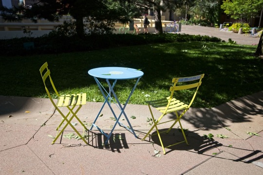
Text
Table and chairs, Loring Greenway, Minneapolis.
#minneapolis#minnesota#twin cities#loring greenway#photography#photographers on tumblr#original photographers#canon 6d
3 notes
·
View notes
Text
I sought refuge from the coronavirus shutdown in urban nature. Eventually, this poem emerged.
get headlines https://thecherrycreeknews.com
During the first few weeks of social distancing, the only regular opportunity that I had to get outside was to walk the South Platte River Greenway, which is just behind my apartment in RINO. These walks during the beginning of spring produced many reflections on the surrounding environment: from the specifics of the river setting, to the growing issues in the larger society around us. The poem ultimately reached its final form on April 22 — Earth Day.
On the trail
Releasing the pent-up quarantine’s wail
from a loathsome shelter tank,
we thirsted for energy at river’s trail,
trading currency in nature’s bank.
South Platte has gifted refuge before:
when placer’s gold beckoned stage one.
Native memories long defined its shores
where Arapahos danced under the sun.
MORE: See all of our Write On, Colorado entries and learn how to submit your own here.
Now all subject to intractable bind
wrought by the virus at hand,
a rigorous trial attacking body and mind,
only our soul can meet the demand.
There is but one natural escape
where thoughts bounce off water’s gleam,
to reflect without choice on our collective fate
while traversing from factory to stream.
Outside the bank vulnerability cries,
as the Elders have a message to send:
respect the space where danger lies,
our tribulations will eventually suspend.
But vulnerability has a peculiar hue
where disconnection births an anxious cry,
protest gathers upon a dangerous cue
while the hands of fate multiply.
Yet I noticed beauty even amidst the grief,
before quarantine swallowed the whole of day.
As prudence waits for summer’s relief
a serene picture can also allay.
Geese climbing the bank without fear,
as the hiker embarks from mountain’s base,
while goslings at side they hold ever dear,
‘tis no longer a desperate chase.
Ducks swimming and fishing as they please,
in fresh water from seasonal snows,
as the hawk swoops down right over their beaks,
disturbing ripples from the water’s flow.
We know sudden disturbance as well,
of viral reaction and expanding wake,
and like the ducks who stood bravely through the swell
our soul will strengthen on the uptake.
Already registered? Log in here to hide these messages.
Stay on top of it all.
Let us bring Colorado’s best journalism to you. Get our free newsletters.
UNDERWRITTEN BY TOBACCO-FREE KIDS ACTION FUND
OUR UNDERWRITERS SUPPORT JOURNALISM. BECOME ONE.
Nature has seen such convulsions before
in a history of ages gone by,
the river’s song continues this lore
for as long as the birds can fly.
One final message to circle this tale
from an ageless rhythm and rhyme:
a solemn melody to part with the trail,
though circle is broken only for a time.
Fate has disturbed a comfortable sound,
bringing the cacophonous challenge of our days,
let us turn this weary vinyl around
then pause before we play.
Mother nature will be there no matter our choice,
where her songs never skip the tracks.
The only question is whether we hear her voice
… and its call to welcome us back.
Michael Sage teaches political science at Community College of Denver.
Already registered? Log in here to hide these messages.
Stay on top of it all.
Let us bring Colorado’s best journalism to you. Get our free newsletters.
The latest from The Sun
Meatpackers welcome Trump’s order that they stay open while others — including Colorado’s governor — question the coronavirus risks
Skier killed in avalanche near Crested Butte
Colorado hopes to test anyone with coronavirus symptoms by May 15, governor says
Colorado nursing home, senior care center coronavirus deaths hit 431, make up 56% of state’s fatalities
Texas attorney general helped donor fight virus lockout in Gunnison County
from https://ift.tt/3bPX9Uf https://ift.tt/3f3gNOv
0 notes
Photo
at Loring Greenway Association https://www.instagram.com/p/Bz6rBjShddj/?igshid=1iaqzx0rljhqq
0 notes
Text
Planning to Hang Posters?

At the Hyatt Regency Minneapolis, CONvergence members may hang family-friendly signage advertising parties, panels, performances, events and more in CONvergence event spaces, and in room party hallways on floors 3, 4, and 5. CONvergence members may begin hanging posters at 8:00am on Thursday, July 4, 2018.
DO NOT Hang Posters:
At the Hyatt front desk, Hyatt Marketplace, Fireside Lounge, the Prairie Kitchen & Bar, or from railings overlooking any of these
In stairwells, escalators, elevators, or elevator doors
In the Skyway bridge connecting the Hyatt with the Millenium
On storefronts or in businesses co-located with the Hyatt, including the Fedex, Vitali’s Cafe, and Salon Blu
On glass surfaces
On doors or door frames
Anywhere outdoors, including Smokers Paradise, the Loring Greenway, or any parking ramp
DO Hang Posters:
Virtually anywhere around CONvergence function space, as indicated on the maps
In room party hallways on floors 3, 4, and 5
On the walls of your own party room
If you are unsure whether you should hang your poster in a particular location, please find a CONvergence Operations volunteer or stop by The Bridge and ask!

Remember to use the One True Tape! Anything affixed to the wall or other surfaces at the Hyatt Regency Hotel MUST be secured with low-tack blue painter’s tape. All brands and models of true blue tape are permitted.
Any posters found to be secured using other kinds of tape will be taken down without notice. Low-tack blue painter’s tape can be found at most hardware stores. If you run out of tape during the convention, stop by The Bridge—they may have some available.
Any posters you hang must be removed no later than 8:00pm on Sunday. Members who hang posters are expected to also remove them.
0 notes
Text
Bike town, Hot Springs
Spa City contemplates a future where cyclists drive tourism.
The hippest new place to stay in Hot Springs leans heavily on the past while peering into the near future. The Best Court Motel, 638 Ouachita Ave., is a fully renovated motor court, that bygone brand of motel designed with the early car traveler in mind. It's a U-shaped collection of connected brick cottages, each with a small front porch and an attached garage.
But the garages aren't for cars anymore, co-owner Jimi Brazil says. He's expecting visitors to soon stow their muddy (and often expensive) mountain bikes there.
Like Brazil, Steve Arrison, the longtime CEO of Visit Hot Springs, the Hot Springs Advertising and Promotion Commission, envisions a not-too-distant future for Hot Springs where cyclists contribute as much to the tourism economy as folks coming to take in the natural baths, boat on Lake Ouachita or Lake Hamilton or to play the ponies and the "electronic games of skill" at Oaklawn (which would become an actual casino, with real cards and table games, if voters approve Issue 4 on Nov. 6).
The excitement surrounds the Nov. 17 opening of phase one of the Northwoods Trail project, 14 miles of multiuse trails designed especially for mountain bikes just minutes from downtown. The trails are the centerpiece of the newly opened Northwoods Urban Forest Park, 2,000 acres of pristine woodlands north and west of downtown's Park Avenue. The park includes three lakes that were built as drinking-water reservoirs: 13-acre Lake Bethel, 24-acre Lake Dillon and 28-acre Lake Sanderson. The lakes, along with much of the park, have been closed to the public since Sept. 11, 2001, for security reasons.
The park's craggy hills and dense groves of oaks would be reason enough for outdoor enthusiasts to flock to the new park. But Arrison and other Hot Springs officials are positively giddy about what sets Northwoods apart: Because mountain biking happens in the wilderness, it's rarely as accessible to other tourist attractions as Northwoods will be. "Mountain bike, get a beer at a place like Superior Bathhouse Brewery and soak in a bath — what a vacation!" Bill Solleder, marketing director for Visit Hot Springs, offered as a quick pitch during an October tour of trail construction.
A drive from downtown to Northwoods' Waterworks Trailhead takes under 5 minutes. Sometime next year, Arrison hopes to see a new connection at Pullman Avenue, which would allow mountain bike tourists to easily pedal from wherever they're staying downtown to Northwoods. Because the Pullman Avenue Trail Connection crosses about an eighth of a mile of National Park Service land, it will require an environmental assessment in accordance with the National Environmental Policy Act. The process is proceeding smoothly, Arrison said.
The other key differentiator for Northwoods: Most of its trails, though officially multiuse, won't be mistaken for hiking trails. They're being built like racetracks, with huge angled berms, hairpin turns, rocky obstacles and massive dirt ramps. One black section — like ski runs, mountain bike routes are designated green for beginner, blue for intermediate riders and black for advanced — features a jump that sends a rider more than 20 feet across a man-made gap some 6 feet deep.
Hot Springs was in 2015 designated a bronze-level ride center by the International Mountain Bicycling Association, thanks to its proximity to three trails IMBA has designated as "Epic — iconic, adventurous, backcountry trails": the 33-mile Womble Trail, the 108-mile Ouachita National Recreational Trail and the 45-mile Lake Ouachita Vista Trail (LOViT). Those routes fit in the cross-country category. Although Northwoods will offer a diverse range of trails for all skill levels, it's likely to especially be a draw for dirt jumpers, advanced mountain bikers who are looking for trails that ride like rollercoasters, but with cars flying off the track.
IMBA's Trail Solutions, an international leader in mountain bike trail development, designed and constructed phase one of Northwoods. The $1.3 million project was funded by Visit Hot Springs and a matching grant from the Walton Family Foundation, which has put $74 million into cycling infrastructure in Northwest Arkansas. Josh Olson, a contractor for Trail Solutions, has been working on the trails since February and living with his crew in an Airbnb just above the Lucky 13, a black diamond trail designed by Randy Spangler, a famed mountain bike pro and designer. Olson has traveled abroad and around the U.S. — to Austria, Utah, Idaho, West Virginia, Colorado, Alabama — building trails.
Another Trail Solutions specialist designed all the trails, considering topography and hydrology, and input them with GPS coordinates, so Olson and his team could access the layout. Olson and Co. are using mini-excavators and chainsaws to clear and build up trails. A "hand crew" follows behind to do fine detail work to try to make the trails look like they've been around for a while. "At first it looks like a construction zone, that it's disturbed," Olson said. "But at the end we want to naturalize it. We're going for an aesthetic that's connected to nature — with jumps."
For a demo, Olson rockets his fully tricked-out Specialized bike — carbon frame, carbon wheels, disc brakes, rear shocks (somewhere in the range of $7,000) — down a hill, swinging around a tree and gaining speed before climbing a short incline and launching off a rocky perch down into a short valley. He's a Colorado native, but peripatetic. "Jumping really makes me want to travel," he said.
Local riders may be wary to take some of the big jumps initially, Olson said. An alternative route accompanies each jump feature. Because most of the mountain biking around Hot Springs has been geared to cross-country riding, that's what local cyclists favor. Hot Springs' Cayden Parker, 14, is the USA Cycling Mountain Bike national champion in cross-country, but he hasn't been interested in taking the big jumps in Northwoods during demo sessions, Solleder said. But, as pro-level riders come to town for dirt jumping, locals will take notice and start developing the skill, Olson predicted.
Visit Hot Springs and IMBA have already planned phase two of the project, which would expand the total number of miles in the park to about 44 and include loops around each of the lakes. A trail over the Lake Bethel dam is also envisioned. Nonmotorized water sports could be another attraction. Funding has not yet been promised for the second phase, though the Walton Family Foundation would seem to be a likely prospect.
Arrison said he's watched closely at how bike projects have stimulated the economy in Northwest Arkansas. A study commissioned by the Walton Family Foundation found that it provided $137 million for the region in economic impact in 2017. "We've worked very closely and watched the blueprint of what Tom and Steuart Walton and the Walton Family Foundation have done in conjunction with Visit Bentonville," Arrison said. "If you think about it like 'Star Wars,' they're the masters and we're the Jedi in-training."
The first phase of Northwoods will connect to Garland County's 10 miles of Cedarglades mountain bike trail. With the Hot Springs Creek Greenway Trail, a 4-mile trail from downtown Hot Springs to Lake Hamilton, nearing completion and the Southwest Trail, which would link Little Rock Central High National Historic Park with Hot Springs National Park, looming somewhere on the horizon, Hot Springs may be known first and foremost as a biking town before too long.
Drink!
After you've pedaled hard and spent through all the adrenaline in the Northwoods, of course you're going to want a beer. SQZBX (236 Ouachita Ave.) is the city's top new spot. Spouses Cheryl Roorda and Zac Smith, known widely as the polka duo Itinerant Locals, co-own the pizzeria and microbrewery (Smith handles all the brewing) and share space with KUHS-LP, 97.9, the solar-powered radio station they helped found. The structure used to house a piano repair shop; Roorda and Smith won a preservation award for their work restoring the beautiful building, which they've creatively decorated with retired accordions and old piano parts. The couple also just bought Starlite Club (232 Ouachita Ave.), the dive bar next door and, naturally, it's become the place to be after dark, too. Another beautifully renovated space: Superior Bathhouse Brewery (329 Central Ave.), in the old Superior Bathhouse along Bathhouse Row, is the ideal spot for unwinding and people- watching downtown. Its beers, perhaps unique worldwide, are brewed using thermal water.
Sleep!
If it's been a minute since you ventured to Hot Springs and left scratching your head wondering why there weren't any nice places to stay in such a tourist mecca, take note! The boutique Waters Hotel opened in 2017 in the 1913 George R. Mann-designed Thompson Building, 340 Central Ave., and raised the bar on downtown accommodations. In its lobby, The Avenue does fine dining with a Southern flair. At 658 Ouachita Ave., Best Court Motel reopened in July after an extensive renovation. The large rooms have been updated with a modern but understated touch and include vintage-looking mini fridges and Adirondack chairs in the garage for sheltered, open-air lounging. Co-owner Jimi Brazil called one of the larger units the Marilyn Monroe suite. According to local lore, a baseball teammate of Joe DiMaggio's owned the motor court next door to the Best Court, but its rooms were too small for Monroe, who insisted they stay next door in the Best Court suite.
Bike town, Hot Springs
0 notes
Photo

Great shot from Loring Park Greenway! Still some amazing fall colors happening out there. #bikelife #dailyride #mnfall #fallcolors #cyclinglife #tonkacycleandski #ridegiant #giantbikes #ridewithfroth (at Loring Park) https://www.instagram.com/p/BpS9MM9h22w/?utm_source=ig_tumblr_share&igshid=1sllq1ogafz60
#bikelife#dailyride#mnfall#fallcolors#cyclinglife#tonkacycleandski#ridegiant#giantbikes#ridewithfroth
0 notes
Last Seen Blogs

legendarytommy
a galaxy not so far, far away


ruahaimi
Untitled

cuteanimalflufffluffs
cuteflufffluffs

angoart
An.Go Treasure Box