#water management
Text
Thematic Report to the 79th session of the United Nations General Assembly “Water and food nexus: a human rights approach to water management in food systems”.
The Special Rapporteur on the human rights to safe drinking water and sanitation, Pedro Arrojo Agudo, is inviting inputs from States and other stakeholders to inform his thematic report on “Water and food nexus: a human rights approach to water management in food systems”. The report will be presented at the United Nations General Assembly's 79th session in October 2024.
The Special Rapporteur on the human rights to safe drinking water and sanitation understands that the dominant systems of large-scale food production and comercialication are harming the human rights to safe drinking water and sanitation worldwide. For the Special Rapporteur, under the argument of producing more and more food for a growing world population, the right to food is often used as an argument to justify unsustainable water management, overusing water sources and affecting aquatic systems, resulting in contamination or scarcity of water needed for human use. As reflected in Special Rapporteur´s report A/HRC/54/32 of 2023, guaranteeing the human right to water for the most impoverished requires restoring the good state of the aquatic ecosystems on which they depend for their water supply. In addition, over-exploitation and pollution of aquatic ecosystems often undermine small-scale food production for self-consumption in impoverished rural communities.
In this connection, the Special Rapporteur would like to call member states, non-state actors, civil society, academia, indigenous peoples, individuals, and other relevant stakeholders to send their contributions and experiences related to the sustainability of aquatic ecosystems and freshwater sources and the systems used to produced food. The Special Rapporteur would appreciate receiving inputs on the interlinkages between both rights and the positive and negative experiences on sustainable (or unsustainable) use of water sources by food systems, including court rulings at global, regional, national, and local levels.
The Special Rapporteur wishes to thank States, indigenous peoples, civil society organisations, academic institutions, businesses, international organisations, individuals, and other stakeholders for their continued engagement with this mandate.
Key information sought: To facilitate the reception of inputs, the Special Rapporteur prepared a list of key information which he considers essential for the report. The list could be answered entirely or partially according to the expertise and experience of those actors willing to contribute to the Report. List of topics: English | Français | Español
How inputs will be used
All submissions will be published on the website of the mandate. Non-state actors could request the confidentiality of the submission.
Next Steps
Please send your contributions via email, indicating “Input Water and Food Nexus” in the email subject line. Your contribution should be sent by no later than 15 March 2024
Email address: [email protected] AND to [email protected].
Email subject line: Input water and food nexus
Word limit: 2500 words
File formats: Word, PDF
Accepted languages: English, Spanish, French
#Special Rapporteur on the rights to water and sanitation#sdg6#water resources#water governance#human rights approach#call for imputs#safe drinking water#OHCHR#Water and Food Nexus#UNGA79#water management#water goals#member states#non-state actors#civil society#academia#indigenous peoples#individuals#stakeholders
16 notes
·
View notes
Text
youtube
Permaculture instructor Andrew Millison journeys to South India to film the ancient Chola Dynasty water management system of lakes and canals that has been restored in the City of Coimbatore by the Coimbatore Lakes Protection Organization ( In Tamil: Kovai Kulangal Padhukappu Amaippu). We visit multiple structures that have been restored, and see the incredible effects that this work has had on the water availability and groundwater levels of the surrounding areas.
KKPA:
Website - http://kovaikulangal.org/ Fb - / kovaikulangal Youtube - / @kovaikulangalpadhukap...
Instagram - Kovai_kulangal_Padhukaapu
Twitter - https://twitter.com/KAmaippu?s=08@KAm...
Mail I'd - [email protected]
Mob. No. - 8015714790
இதயத்தின் ஈரம் கொண்டு...! புவியின் ஈரம் காப்போம்...!
Post Production by Meenarts.com
Digital Map Animation:
https://www.pearlriverecodesign.com/
Shubo Biswas of GreenGood Labs:
https://www.greengoodlabs.com/
Drone Credits: Gopinath, @cymatics.in.
PERMACULTURE DESIGN COURSE LINK:
https://workspace.oregonstate.edu/cou...
Andrew Millison’s links:
https://www.andrewmillison.com/
https://permaculturedesign.oregonstat...
JOIN THIS CHANNEL to get access to uncut video content and live Q & A sessions:
/ @amillison
SIGN UP FOR MY FREE NEWSLETTER:
https://share.hsforms.com/1X79TznHYRC...
#Andrew Millison#solarpunk#permaculture#india#Chola Dynasty#water management#water#irrigation#lakes#canals#Coimbatore#Coimbatore Lakes Protection Organization#Kovai Kulangal Padhukappu Amaippu#ground water#groundwater#water table#watershed#Youtube
16 notes
·
View notes
Text
As the changing climate increasingly disrupts our ways of life, we have three choices: do nothing, attempt to stop or even reverse climate change, and/or figure out how to withstand it. Option one is a terrible idea and the ship has (mostly) sailed on option two. But option three is how we learn to live—and maybe even thrive—in our changing world. Part of this is figuring out how to convey the information that climate researchers have gathered to the people—like farmers, water managers, and urban planners—who need to make decisions now—about things like what crops to plant, where to get water for everyone and how to allocate it, and where to plant trees—for both the near and slightly distant future. In this episode, we’re talking to Professor Lisa Dilling, of the University of Colorado, Boulder, about building networks of people through which information about regional climate predictions can flow to people and information about the needs, predicaments, and questions of people can flow to climate researchers.
You can follow Lisa Dilling on Twitter at @LisaD144, and the Western Water Assessment program at University of Colorado here: @WWAnews or visit their website at https://wwa.colorado.edu/
Connect with Solarpunk Magazine at solarpunkmagazine.com and on Twitter @solarpunklitmag
Connect with Solarpunk Presents Podcast on Twitter @SolarpunkP, Mastodon @[email protected], or at our blog https://solarpunkpresents.com/
Connect with Ariel at her blog, on Twitter at @arielletje, and on Mastodon @[email protected]
Connect with Christina at her blog, on Twitter @xtinadlr, and on Mastodon @[email protected]
#Lisa Diling#solarpunk#Solarpunk Presents#podcast#Solarpunk Futures#season one episode nine#climate change#water management#University of Colorado#Boulder#University of Colorado Boulder#climate research#farming#urban planning#future-proofing#regional climate predictions#science communication#climate communication#climate change adaptation
30 notes
·
View notes
Text
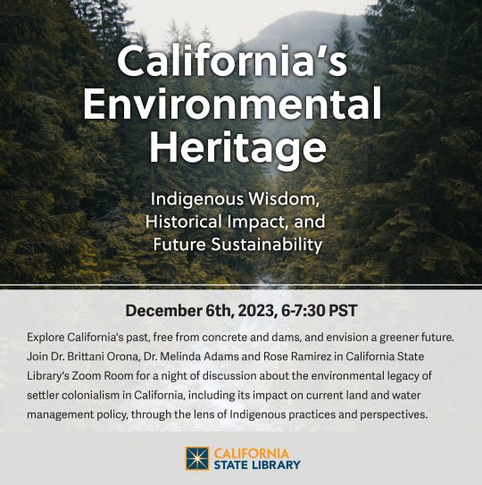
Explore California's past, free from concrete and dams, and envision a greener future. Join Dr. Brittani Orona, Dr. Melinda Adams and Rose Ramirez in California State Library's Zoom Room for a night of discussion about the environmental legacy of settler colonialism in California, including its impact on current land and water management policy, through the lens of Indigenous practices and perspectives. To register, please visit https://libraryca.libcal.com/event/11406831.
#Water Management#Indigenous History#Indigenous Cultures#california#california history#colonialism#environmentalism#virtual event#native american peoples#native american tradition
13 notes
·
View notes
Text

Aquaduct Veluwemeer - Harderwijk
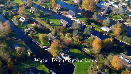
Vinkenveen / Vinkenveense Plassen

Giethoorn

Kinderdijk

Amsterdam Canals

Zaanse Schans
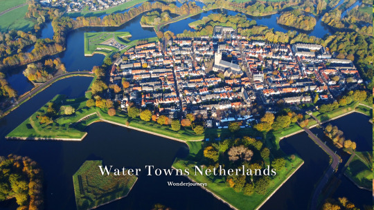
Naarden
Under Sea Level Living in The Netherlands
Walking & Drone tour ::
youtube
#travel#youtube#wanderlust#wonderjourneys#tourism#touristdestination#drone#dji#amsterdam#giethoorn#kinderdijk#unesco#unesco world heritage#windmills#keukenhof#zaanse schans#naarden#water#sea level#water management#dutch#under sea level#aquaduct#veluwemeer#veluwe#Youtube#the netherlands#netherlands#niederlande#paysbas
6 notes
·
View notes
Text
She wore a foaming wave as a rain cape, a swirl of absorbing water. When the storm was done, she deposited the water in a safe place - an unblocked drain, a field, an existing waterway. Sometimes she threw it at a rude motorist who didn’t respect pedestrians.
#rain cape#foaming wave#urban fantasy#simple magic#water witch#wizards cloak#water management#pedestrian safety#like attracts like
17 notes
·
View notes
Text
California is letting billions of gallons of stormwater wash out to sea each year, report finds
Mar. 1, 2024 - LA Times
For too long, California and other states have viewed stormwater as either a threat or an inconvenience — something to be whisked away from cities and communities as quickly as possible...
In a report released Thursday, researchers with the Pacific Institute determined that every year, 59.5 million acre-feet of stormwater go uncaptured across the United States — or roughly 53 billion gallons per day. The amount is equivalent to 93% of the water withdrawals for municipal and industrial uses in 2015, the most recent year for which national data were available...
Of the 10 states with the most “untapped potential,” California ranks ninth with approximately 2.27 million acre-feet of urban area runoff each year. (An acre-foot is about 326,000 gallons — enough water to supply up to three homes for a year)...
In other words, there is no drought!
#orgone#orgone energy#orgonite#rain#weather#water#water management#rain water collection#los angeles#california#drought#climate#climate change#geo-restoration
6 notes
·
View notes
Text

When the wells dry, we know the worth of water. - Benjamin Franklin

#albuquerque#new mexico#photography#water management#living simple to simply live#urban photography#urban landscape#black and white#b&w photography#mine
3 notes
·
View notes
Text
"As Albert Einstein explained in 1905, the photoelectric effect occurs when light shining on a material contains enough (quantized) energy to eject an electron from the material. By analogy, and drawing on his understanding of Maxwell’s equations and the polar nature of water molecules, [Gang] Chen rationalized that the impetus behind his team’s observations might involve a quadrupole force acting on a permanent dipole at the air-water interface."
"Chen believes this new mechanism, which he and his colleagues describe in PNAS, could be at play in our daily lives. “It might be important, for example, for understanding the Earth’s water cycle, global warming, and plant growth,” he says. “The discovery could also lead to new engineering applications: we have started to look into desalination and wastewater treatment, but drying could be another area in which this mechanism could be exploited.” Because drying consumes around 20% of energy used in industrial sectors – an amount Chen calls “staggering” – an increase in energy efficiency could have a significant impact."
continue reading article
#water#light#energy#photomolecular evaporation#physics#science#discovery#einstein#nature#water cycle#atmosphere#weather#climate#waste water treatment#water management#desalination#drinking water#polarity
4 notes
·
View notes
Text
Unraveling the Growth Potential of the Geofoams Market: Global Outlook
The global geofoams market size is expected to reach USD 972.6 million by 2027, expanding at a CAGR of 2.7%, according to a new report by Grand View Research, Inc. Factors such as availability of geofoams at low cost coupled with its superior strength and durability are projected to fuel the market growth. Expansion of the construction industry across the globe coupled with the infrastructural developments in economies such as India, China, Brazil, Mexico, Saudi Arabia, and others is expected to propel the demand for geofoams over the forecast period. In addition, maintenance of the existing infrastructure in developed nations is likely to drive the growth of the market.
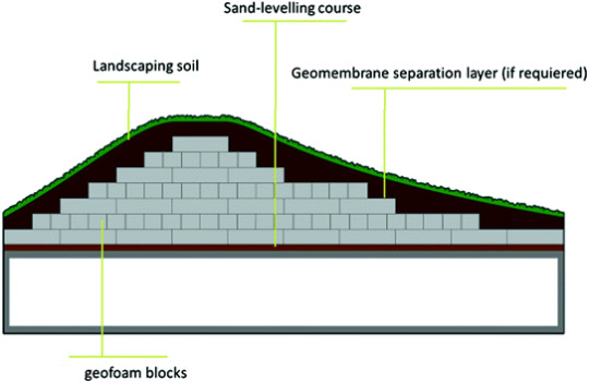
Geofoams Market Report Highlights
The expanded polystyrene geofoams segment accounted for USD 508.2 million in 2019 and is projected to expand at a CAGR of 3.1% from 2020 to 2027. The compatibility of the product has resulted in its increasing adoption for applications including roads and highway construction, building and infrastructure, and others
The road and highway construction application segment accounted for 38.07% of the total market and is projected to expand at a CAGR of 3.4% from 2020 to 2027 on account of the rising infrastructural growth across the developing economies including China, India, Brazil, UAE, Saudi Arabia, and others
Asia-Pacific accounted for USD 278.5 million in 2019 and is estimated to expand at a CAGR of 3.2% from 2020 to 2027 owing to the rising demand for road pavement, which is anticipated to further benefit the growth
China accounted for the highest market share in Asia Pacific on account of the rapidly expanding construction industry in the country
Europe market is estimated to expand at a CAGR of 2.8% owing to the rising number of construction and infrastructural activities in economies including Spain, Italy, and others
For More Details or Sample Copy please visit link @: Geofoams Market Report
Geofoams are increasingly used in the construction industry as it helps in suppressing the noise and vibrations. In addition, it is easy to handle and does not require any special equipment for installation. The product is increasingly used in the railway track systems, below the refrigerated storage buildings, storage tanks, and others to avoid ground freezing.
The geofoams undergo chemical changes when it comes in contact with petroleum solvents. It turns into a glue-type substance, thereby losing its strength. This factor is projected to limit the use of geofoams in the construction industry which is projected to restrict the industry growth over the forecast period.
#Geofoam#Expanded polystyrene (EPS)#Geofoam blocks#Construction materials#Road and highway construction#Retaining walls#Geotechnical engineering#Soil stabilization#Environmental protection#Earthquake resistance#Noise and vibration control#Water management#Hydrostatic pressure#Thermal insulation#Structural stability
3 notes
·
View notes
Text
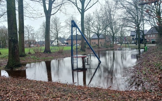
Current state of the playground. That's just how high the water level in the soil is right now. It's got nowhere to go. And it just started freezing
2 notes
·
View notes
Text
2nd session, 14th Meeting of the Task Force on Water and Climate.
The fourteenth meeting of the Task Force on Water and Climate aims to discuss, plan and provide guidance to the implementation of the activities on Water diplomacy and Climate change under the programme of work for 2022-2024 of the Water Convention as well as to the planned activities under the next programme of work for 2025-2027 of the Water Convention. UN Web TV
Watch the 2nd session, 14th Meeting of the Task Force on Water and Climate.
#task force#Task Force on Water and Climate#water resources#water management#sdg6#groundwater#water convention#water and climate#climate change#plenary session
8 notes
·
View notes
Photo
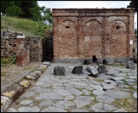

The Castellum Aquae (Water Castle), Pompeii.
The point at which water entered Pompeii via aqueduct.
#pompeii#castellum aquae#aqueduct#water management#hydroengineering#ancient rome#ancient roman#architecture#ancientprettythings
54 notes
·
View notes
Link
Excerpt from this story from Inside Climate News:
Last month, with California in the grips of a megadrought, Gov. Gavin Newsom announced a plan centered on “the acute need to conserve water” in the face of a drier, hotter future caused by climate change. The plan outlines actions to “transform water management” and calls on California residents to step up and do their part to conserve water.
Yet the plan does nothing to limit use of California’s dwindling water supplies by one of the primary drivers of climate change: the oil and gas industry.
An Inside Climate News analysis of data collected by the California Geologic Energy Management Division, or CalGEM, shows high-quality water is being diverted from state domestic and agricultural supplies, predominantly in Kern County, to extract viscous crude from some of the world’s most climate-polluting oilfields.
The analysis also reveals deep problems with the quality of the data collected by CalGEM that make it very difficult to establish the quantities of water used to produce oil—despite a 2014 law that was supposed to overhaul the industry’s water-use reporting in order to provide greater transparency.
Oil and gas extraction in California uses tens of billions of gallons of water each year. It also generates massive amounts of wastewater, known as “produced water,” which returns to the surface with extracted fuels. This produced water is laced with cancer-causing chemicals added to facilitate oil extraction, harmful petroleum-derived compounds and naturally occurring toxic elements such as arsenic and radium.
Although most of the water the industry injects into wells to help extract oil is recycled produced water that is used again to pry out more oil, some extraction techniques require high-quality water. Under these circumstances, it can be cheaper to buy clean water from municipal suppliers than it is to treat produced water to remove contaminants.
Extracting heavy crude oil in parts of Kern County requires more water, and disproportionate amounts of high-quality water, than other regions in California because the oil is so viscous and the wells are so old.
Kern County produces about three-quarters of California’s onshore oil and gas, but wells there account for more than 99.5 percent of this high-quality water injected for fossil fuel extraction across California, according to the Inside Climate News analysis. This water could otherwise go to farms and municipalities that have had to ration their water supplies.
27 notes
·
View notes
Text
Keeping the Water in the Ground with Swales
It’s scorching hot and the rains just won’t come. You can use water from your well to keep your plants from dying, but under these conditions the water table could just drop, leaving you high and dry. Then, when the long awaited rain comes, half your topsoil could get washed away in the downpour. So horrible, yet so familiar! Fortunately, there is a really neat technique that makes sure your water will stay on – or rather under – your land, instead of ripping through the surface before flowing away never to be seen again.

image source
The Behavior of Water
It’s a good idea to take a close look at what water does during a heavy rainstorm. True, most of us don’t enjoy running around under the open sky when it’s raining cats and dogs. But it can be very educational to observe the natural flow of water. It always takes the quickest way down (never up). And depending on the flow, which in turn depends on the amount of water and the ground’s inclination, it can even tear its own way through the landscape. If the ground is fairly dry and without much vegetation, you will even see how a small stream can create a gully – growing into veritable canyons – by carrying sediment with it.
image source
That sediment may be your valuable topsoil! And fairly soon after the rain stops, it will be gone, along with the stream of water. Where did it all go? Just follow the canyon, and you are likely to find it leading away from your land, towards the lower elevations.
But That’s What Water Does. How Can We Counter It?
Admittedly, we will never change the natural behavior of water. What we can do, however, is use it for our purposes. So if it really always goes downhill, let’s give it a place to go: a ditch dug out on the contour line of a hill, which is known as a swale. And that’s all! Since the swale is on contour, meaning that it’s completely horizontal, the water is not going to go anywhere from there until the swale is full (something we must also prepare for). Now that the water lost its momentum, it’s simply going to sit there, and slowly seep downward into the soil. There it won’t have the speed it normally flows with on the surface, so it can’t carry away any soil. Instead it gradually saturates the ground on the hillside below the swale.
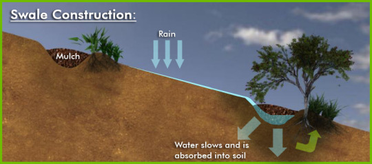
image source
How to Build Swales
It’s really quite simple: First comes the precision work of measuring out the contour line, followed by the grunt work of digging. You may use machines if your topography allows, or do everything by hand, but in either case, exact measurement is the make-or-break aspect of a swale. There are many different methods for this, ranging from the modest (yet effective) A-frame, to the hose level, all the way to the high-tech laser level.

When you are certain that the line is exactly horizontal, you can start digging the trench. Though it can be smaller, I personally like a bigger swale of about 2’ width and depth. That way it can take up more water, and over time it will be gradually filled with soil anyway. What’s most important when digging the swale is to make sure that the bottom remains exactly on contour! The excavated soil we pile up on the side of the ditch that’s sloping downward. This berm is an ideal place to plant trees into to hold the soil together, to help with water saturation and dispersal, as well as to shade the swale to slow down evaporation. In a great design they will also grow something you can eat.
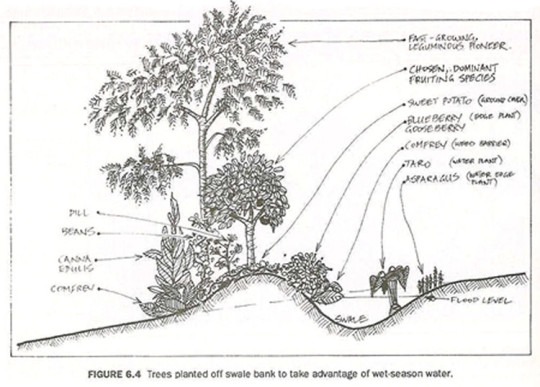
image source
There are a couple of things to look out for: For one thing, the swale should never be placed directly above any buildings (gardens are a much better idea). The best place for them is high up on a hill. Also, make sure the slope doesn’t exceed 15 degrees. Both of these are basic safety measures against slides. It’s also important to make sure the bottom of the swale has a decent water saturation, of at least an inch per hour. Finally, one must prepare for record level rainfall, in other words even the best swale will fill up… and then what? The water needs to go somewhere! So have the overflow channeled into a pond, a dam, or any other feature you have installed for water management.

image source
Okay, so you’ve measured out the contour line, dug a nice big swale, planted trees into the berm, and double-tripple checked that the bottom of your ditch is perfectly level. Great, now you can lean back and wait for the rain! When it comes, get out there again to see how your swale is performing.
Maintenance and Long-Term Effects
After a year or so you can take a look at the swale, preferably when it’s not full of water. You’ll see that it’s not as deep any more as how you dug it. It has filled up with soil: your topsoil! This is your land, that otherwise would have been carried away to your neighbor, or eventually into the ocean, to be lost forever. But here it is, ready to be dug out and used for planting. Of course once again, it’s important to keep the bottom completely leveled.
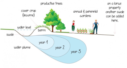
image source
The other effect you are not likely to see immediately, is the water inside, that is under your ground. This is a very gradual process, but the water is going to hang around much longer inside the soil than on the surface. After a while it adds to the water table, and … depending on numerous factors … it will raise it again. There have been many accounts of wells that have been dry for years started having water again, a few years after a swale was built on a nearby hill. But since farming and gardening naturally makes you want to think long-term, this technique will fit right into it.
sources: 1, 2, 3, 4, 5, 6, 7, 8, 9, 10
27 notes
·
View notes
Text
On asking Chat GPT the difference between water management and sanitation between the America and Europe:
While it's true that many Indigenous cultures in the Americas had sophisticated systems for water management and sanitation, it's important to note that these systems were often region-specific and may not have been applicable or feasible in other regions. Additionally, Europeans had a different set of cultural and technological priorities when it came to urban planning and infrastructure development.
In many European cities, the focus was on building large cathedrals, fortifications, and other monumental structures, rather than investing in extensive water supply and sanitation systems. The lack of clean water and sanitation infrastructure in European cities contributed to the spread of disease and poor hygiene practices.
Furthermore, the loss of knowledge and expertise in engineering and infrastructure development after the fall of the Western Roman Empire in 476 CE also contributed to the lack of running water in Europe during the medieval period. While some water systems were developed in certain European cities during the Middle Ages, they were often limited in scope and did not reach the wider population.
Overall, the reasons for the lack of running water in Europe during the medieval period are complex and multifaceted, and cannot be solely attributed to climate or cultural differences.
#chat gpt#chat bot#history#europe#america#americas#ok so what has changed TT#Europe was focused on building cathedrals and not water sanitation or management#and thus contributed to the spread of disease and poor hygiene mangement#and most of the religious controls are still focused on the church#and many do not tax the church#it's been 100s of years...#middle ages#water management#water sanitation#anti theist#anti religion#catholic#christian#the church#religion#water#bathing practices#roman#engineering#ancient civilizations#ancient history
4 notes
·
View notes
Last Seen Blogs

wanderingdazes
treat people with kindness.

hazbin-charlastor-hyperfixation
~So Many Orphans~

centralautorepairs
Central Auto Repairs

innerpaperdeputywolf-blog
cleaning service

the-calendar-coalition
Welcome to the Calendar Coalition