#straits settlements
Text
#nations of the world tournament#poll#polls#propaganda encouraged#United Kingdom of Great Britain and Ireland#Straits Settlements#Nations of the world 1914#Nations of the world retro
3 notes
·
View notes
Photo

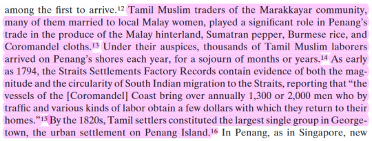
The Straits Settlements became a British Crown Colony on 1 April 1867, making the Straits Settlements answerable directly to the Colonial Office in London instead of the British Raj of British India.
The coin's obverse and reverse were redesigned and silver coin designs were added in the form of new 5, 10, 20, and 50 cents.
#numismatics#coins#coincollecting#british india#british raj#malaysia#straits settlements#coppercoins#silvercoins#silver#queen victoria
2 notes
·
View notes
Text
one thing i am obsessed with is the assertion that the current situation is all the result of iran’s careful machinations when they quite literally were not involved in this attack per even us intelligence. like actually conspiracy levels of nonsense. israel has been slaughtering palestinians like no tomorrow this entire time and have been getting more and more brazen for a while now. settler violence reached a fever pitch last year. israel is not “forced” to bombard and totally siege a civilian population. they choose to do so. over and over again they choose to do so. the state itself atp is a violation of international law and the UN had said as much over and over and it does not matter because the palestinians do not matter to the most powerful forces in the international community
#fears over whether palestinians will even achieve a decent one state solution have been raised in recent years#many people in gaza have abandoned hope for a two state solution#they are quite literally in dire straits#they are facing a water crisis on genocide levels#and primarily because of increased israeli settlement#and now israeli has a hard right government more hellbent on expanding illegal settlements and brutalizing palestinians than ever#left wing israelis and palestinians have been ringing the alarm#israeli human rights groups have been ringing the alarm#you didn’t hear it. that doesn’t mean you can just make up a conspiracy theory
20 notes
·
View notes
Text

Tamil Diasporas across the Bay of Bengal
0 notes
Note
Top 5 archaeological sites in Australia that you feel people should know more about? Or top 5 Australian artefacts?
I feel like I’ve talked a bit about artefacts in a few recent asks, and also I feel like a lot of Australian archaeology (and as such, sites) are very underrated, particularly on a global scale. Its often acknowledged in Australian archaeology that getting international academia to recognise the importance of our country’s archaeology is very very difficult.
While there’s a million and one sites I’d love to talk about, I’m going to TRY and give sites that relate to different aspects and locations
This is probably going to be long, so...
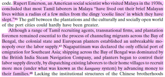
1. Nauwalabila, Madjedbebe (Malakunanja II), and the Deaf Adder Gorge region, Northern Territory (Aboriginal)
Rock shelters in this region, and specifically Madjedbebe, are currently the oldest location of human habitation in Australia. Dating evidence from 2017 excavations provided an estimate of earliest occupation of 50 000 years at certainty, possibly extending back as early as 65 000 (+/-6000). It also has provided a lot of evidence for research into the extensive grind stone technologies of the Pleistocene.
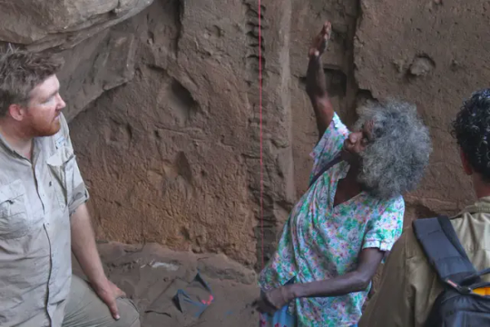
2. Cloggs Cave and the Buchan region of the Victorian Gippsland (Aboriginal)
So much research has been done into this region in various ways. Josephine Flood focused her research on Bogong Moth usage (and festivals) within this region, providing some of the earliest accepted academic research in support of Aboriginal peoples’ claims of large scale Bogong Moth Festivals in Australia’s highlands (although the fac that no one really believed communities until then…………..). In 2021 grind analysis found Bogong Moth residue, making this the earliest stone artefact with evidence of insect food remains. And in addition to that recent 2017 research in the area investigated Holocene occupation with Aboriginal community members, with a focus on understanding the interaction of spirituality with the resources found in the caves.
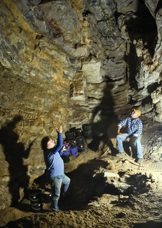
3. Mabuyag Island, Torres Strait Islands, Queensland (Torres Strait Islander)
Mabuyag Island (alternatively known as Mabuiag or Mabuyaagi) has archaeological evidence of human occupation since 7300 years ago. The island is both associated with recent religious practices associated with he heavy processing of dugong remains, and totemic associations with these, which played a role in early 2000s into community lead and directed archaeological research into ritual and religious traditions and practices. In addition to this, Mabuyag is the location of the first archaeological excavations in Australia to find pre-colonial pottery fragments. The fragments at the two sites on the island were associated with Melanesian and Papua New Guinean pottery trade. The excavations relating to pottery on the island played an important role in our understanding of domestic and international trade in pre-colonial Australia, and also formed an influence for the recent excavations at Lizard Island, 300km south, which identified the first datable domestically made pottery technology found in Australia.
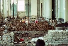
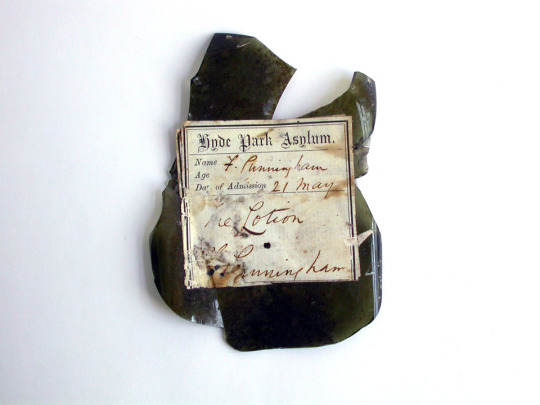
4. Hyde Park Barracks, Sydney, NSW
Hyde Park Barracks is part of a collection of colonial heritage structures in Australia, relating to Australia’s time as a penal settlement. Hyde Park Barracks in particular were the location of the housing of convict men from 1819 to 1830, with the 1830s to 1840s also involving the site being a location of additional convict punishment, and the base for the Board of Assignment of Servants. Following on from a reduction of convicts to NSW in the 1840s, the Barracks became the Female Immigration Depot, and the Orphan Institution, later becoming the Asylum for Infirm and Destitute Women.
This time period of women’s occupation provides some of the most interesting archaeological remains, as redevelopment and management of the site has found high rates of preservation within walls, and in areas below floorboards. This includes textiles and fabrics, papers, and other non-organic materials such as pipes (with their tobacco intact) stashed in what was once floor, wall, and ceiling cavities. Archaeological investigations in the area form one of the most detailed assemblages of artefacts relating to instituted women in the British Empire during the 19th century.

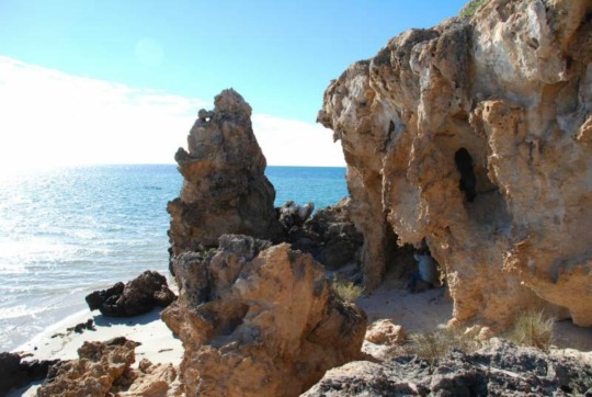
5. Notch Point, Western Australia (Multicultural heritage)
Notch Point is a site of varied and mixed archaeology, ranging from pre- and post- colonial period Aboriginal heritage, to diverse 19th century occupation of the region by Chinese, European, Malay, and Aboriginal peoples in association with pearling industries off the coast. In addition to this, the point is located on Dirk Hartog Island (otherwise known as Wirruwana), the site of the earliest European arrival in Western Australia in 1616, and contains archaeological evidence of both various early Dutch interactions with the island in 1616 and 1697, as well as French arrival in 1772, 1801, and 1818. Notch Point in particular also contains evidence of conflict between the predominantly Chinese population of the pearling industry, with white-Australian and European pearling masters, and pastoral agents. Its not a site that is widely discussed, but provides a fascinating overlay of the amount of varied cultural groups that can be present within Australia’s archaeological sites.
-
-
Honourable mentions to:
Lake Mungo and the Willandra Lakes which should 100% be on this list, but also I feel like I talk about it ALL the time and I wanted to mention sites that I actually don’t see discussed a lot. Theyre super important for cultural reasons, for archaeological reasons, and also for their role the development of archaeology, Aboriginal community consultation, and the role its played in developing repatriation practices in modern Australia. I have multiple posts about them HERE
Budj Bin Eel Traps in Victoria (same reasons, I’ve definitely talked about them before).
Juukan Gorge (and its destruction, im still horrified)
Harrietville Chinese Mining Village
Strangway Strings and The Peake Afghan Cameleer sites
Recherche Bay in Tasmania, and its 1792 French settlement sites
Homebush Mill & Mission Hall in QLD and Beowa National Park sites containing South Sea Islander heritage
#I feel like this constitutes a solid answer#i had fun#and hopefully people learn new things about Australian archaeology#and its diversity#sorry this took literally forever to answer#i got sick for a bit#and then its going to chill in my queue for a couple of days#archaeology#Australia#aboriginal and torres strait islander peoples#they let a mouse do archaeology?#Mice answers things
73 notes
·
View notes
Text
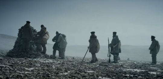
The Terror: When, How, Where... (PART 1)
See part 2 for the end of my sanity (ep 6 through 9. Wasn't enough characters left on the post for ep 10)
See part 3 (and episode 10)
As I am writing the fic, I was getting frustrated at trying to figure out the timeline of the expedition. More specifically, what happens after they dropped the Victory Point Note.
Therefore, in order to organize my ideas, and also because it might be of interests to some of you, I will document here what I got.
Episode 1 through 5 for now.
Methodology
If we agree that the showrunners (and Dan Simmons to an extent) made their research, we should be able to match some of the event of the story with notable point of interests where artefacts and/or remains were found over the numerous searches made to ascertain the fate of the Franklin Expedition
I also tried to take note of all indications of time passing so that I might document their speed travel and the dates when they are not mentioned.
... And the death count. (Departing Beechey Island with 24 officers and 102 men)
Finally, I also used the following website to keep track of sunrises and sunsets: https://www.timeanddate.com/
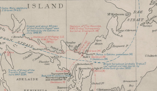
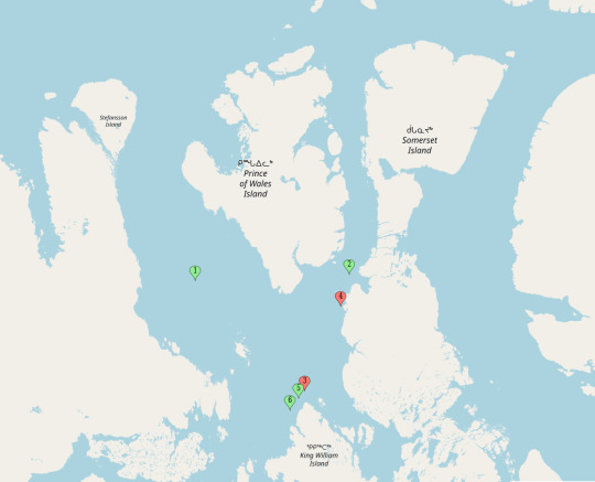
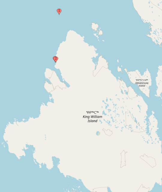
1927 Admiralty Map
I may be an amateur in this kind of research but I find myself frustrated that the most complete map I've been able to find showing all that was found between 1850 and 1926 is shown on this map from 1927

To be noted, we now know that the Skeleton of H. Peglar was more probably W. Gibson or T. Armitage
The Skeleton of Lt. Le Vesconte has also been reevaluated and is now believed to be that of Harry Goodsir ( :( )
Also, as it happens, if we compare to 2024 maps, we can say that this is not the actual shape of KWI (close enough!).
Therefore, for my own sanity, I recreated with modern maps. Is it accurate? Well, I wouldn't publish it but I think it gives a good enough view of where they went and where they were going:
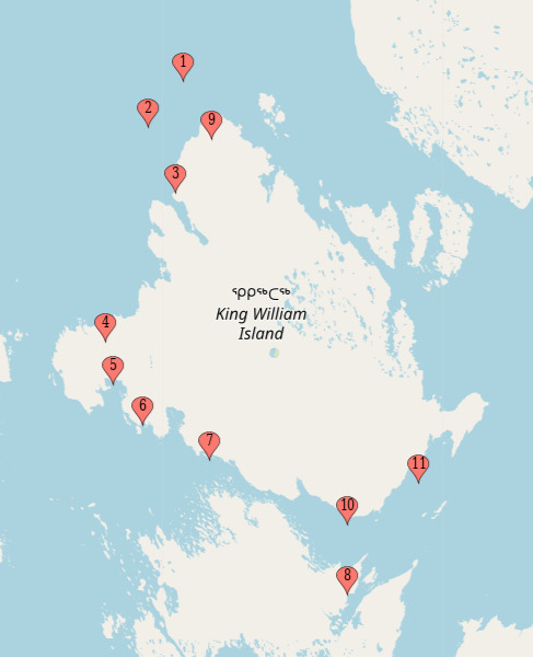

Where the Ships had drifted to in June 1847 (According to G. Gore's coordinates left on the Victory point note)
Where the Ships had drifted with the Pack by April 1848 (Victory Point Note)
Victory Point
McClintock's Boat Place (proposed to be same location as NgLJ-1)
Camp with Many skeletons
From D. Simmons' The Terror - The Hospital Camp
Peglar Skeleton
Starvation Cove
A Bunch of cairns in the area
Harry Goodsir
Gjoa Haven (Netsilik Settlement)
Fort Resolution (Dear God... look at how far they wanted to walk/Canoe/make portage...)
Matching the Show
Episode 1 - Go for Broke
Location 1 - David Young's grave (71.22, -96.60)
Date: September 5th 1846
Nighttime - None
Daylight - 14h 57 min
Twilight - 9h 03 min
Sunset: 7:51 PM - Sunrise: 4:55 AM
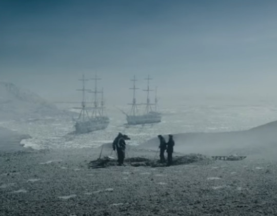
David Young was buried 7 days before they were beset in the ice (see point 3 on the map below).
During the dinner in which we were regaled by the tale of Mr. Fitzjames' Holes, Franklin discuss that they were approaching a bigger channel, which is now know as the McClintock Channel (see point 1 on the map below), meaning that at the time, they were still in the Franklin Strait.
On the day after his death, Franklin discuss their next course and assure that they must be 'nearly in sight of KW Land'. Crozier suggests it might take them weeks to actually make it to KWI. This would confirm what was infer above.
As we can see the two ships fitting in a cozy little cove while the grave is being dug, I would like to propose Point 4 on the map below as Ficitonal David Young's final resting place, on Tasmania Islands
Location 2 - Ships September 1846 (70.25, -98.00)
Date: September 12th 1846
Nighttime - None
Daylight - 13h 45 min
Twilight - 10h 15 min
Sunset: 7:19 PM - Sunrise: 5:34 AM
Well, for this one, we need to use the extrapolation provided by the 1927's Admiralty map by tracing the line from where the ships were known to be in 1847 and 1848 (Point 5 and 6). (see point 3)

For Future Reference:
Travel Time between Loc 1 and Loc 2 - 7 days
Distance between Loc 1 and Loc 2 :70 NM / 80 Miles / 130 km
Average Travel Speed - 11.4 miles a day
Travel Condition - Ice breaking
DEATH COUNT: 2 + 3 (Total 5)
24 Officers and 100 Men remaining
Episode 2 - Gore
Location 3 - The Ships in 1847 (70.15, -98.30)
Date: May 24th 1847
Nighttime - None
Daylight - 24h min
Twilight - None
Sunset: N/A - Sunrise: N/A
Coordinates and Date From the Victory Point Note (see Point 1)
Location 4 - The Cairn (69.66, -98.27)
Date: May 28th 1847
Nighttime - None
Daylight - 24h min
Twilight - None
Sunset: N/A - Sunrise: N/A
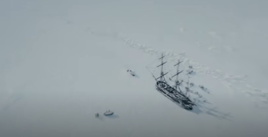
From the ships, Gore lead his party to James Clark Ross' Cairn.
Now, in the Show, they found JCR's Cairn without an issue. In reality, while Gore had found the Cairn just fine, Crozier and Fitzjames did not. One of the reason for it is that JCR had, apparently, made a miscalculation in reporting where he had erected the Cairn by several miles. Honestly, the way that Fitzjames had written the words was so confusing, I appreciate that the show made the whole thing so much simpler, ahah. So let's say that it matches what we know now as Victory Point. Easy Peasy! (see Point 2)
To be Noted, we know the dates of departure from ships and arrival at cairn from the Victory Point Note.
Location 5 - The Ice Camp (69.665, -98.32)
Date: May 28th 1847
Nighttime - None
Daylight - 24h min
Twilight - None
Sunset: N/A - Sunrise: N/A
The Camp was raised just beyond the ice ridge that blocked the way form the shore and the Cairn was only a mile or so away. (see Point 3... hidden between point 2)
Of Note: That hail storm's cloud coverage was intense to say the least... So dark :')
Back to Loc 3 (70.15, -98.30)
Date: June 2nd 1847
Nighttime - None
Daylight - 24h min
Twilight - None
Sunset: N/A - Sunrise: N/A
Wednesday is a good day to drink with the Captain :D which makes it the Wednesday following May 28th 1847! So it's June 2nd!

For Future Reference:
Loc 2 to Loc 3
Travel time - 8 months, 12 days or 254 days
Travel Distance: 8.6 NM / 10 miles / 16 km
Average Travel Speed - 0.04 miles a day
Travel Condition - Pack drifting
Loc 3 to Loc 4/5
Travel time - 5 days
Travel Distance: 29 NM / 33.5 miles / 54 km
Average Travel Speed - 6.7 miles a day
Travel Condition - 6 Men hauling Sledge on Ice
Loc 4/5 Back to Loc 3
Travel time - 4 days
Travel Distance: 29 NM / 33.5 miles / 54 km
Average Travel Speed - 8.4 miles a day
Travel Condition - 6 Men hauling ASS and Sledge on Ice
DEATH COUNT: 1 (Total: 6)
23 Officers and 100 Men remaining
Episode 3 - The Ladder
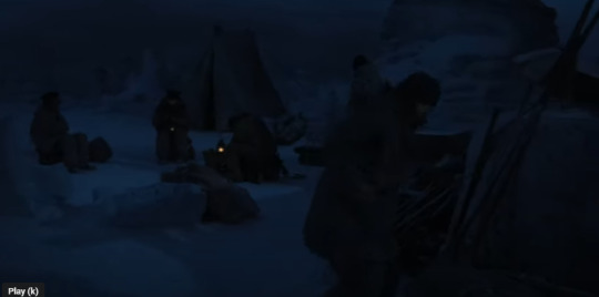
This one is fun because, well... they're not moving! I could point out where Silna ends up but it looks like she remain close enough to the ships that it doesn't matter all that much. So, let's just make note of the date and events:
Location 3 - Ships in June 1847 (70.15, -98.30)
For the duration of the episode:
Nighttime - None
Daylight - 24h min
Twilight - None
Sunset: N/A - Sunrise: N/A
Date: between June 2nd and June 10th 1847
- Silna makes her igloo a few miles away from the Ships
Date: June 11th 1847
- Franklin Dies
- Crozier drafts his resignation letter
Date: June 12th 1847
- Franklin's leg is buried :')
- Lieutenant Fairholme is sent to KWI.
DEATH COUNT: 2 (Total: 8)
22 Officers and 99 Men remaining
Episode 4 - Punished, As a Boy
Another fun bottle Episode!
Location 3 - Ships in same approx position as June 1847 (70.15, -98.30)
Date: November 23rd 1847
Nighttime - 12h 35 min
Daylight - None
Twilight - 11h 25min
Sunset: 11:47 am - Sunrise: 10:51 am
- William Strong's birthday :)
- We know because it's the last sunrise of the year!
- Evans and Strong die :(
They searched for a long time if it was just before 4 pm when they got the alarm and then they came back in time for last sunrise at 11 am...

Date: November 24th 1847 to November 25th 1847
Nighttime - 12h 35 min
Daylight - None
Twilight - 11h 25min
Sunset: N/A - Sunrise: N/A
- Hickey has a communion with Tuunbaq (supposedly next day or so)
- Then Hickey gets evily booped.
DEATH COUNT: 2 + Hickey's postern (Total: 10)
22 Officers and 97 Men remaining
Episode 5 - First Shot the Winner, Lads
More fun in a bottle. These boys are not going far...
Honestly, for this one, the trouble was figuring out how much time had passed. For one, we know it's not yet Christmas because Christmas is, in fact, mentioned in Episode 6 (And Lady Jane's Christmas Pudding, hear hear) as part of the meeting between the officer and there was not yet a cooperation between the Terror Lts and Fitzjames for counting the supplies.
ALSO! That scene where Mr. Wentzell got killed dead over his nail... well, it gave me the feeling that either the review of the crew is not daily or that they've been on Erebus for a short time because 1) Fitzjames doesn't know their names and 2) He has to repeat the instructions about cleanliness... Perhaps they sent the Terrors in waves and not all 50 of them at once.
Other details to be mentionned:
Hickey is not recovered yet and Goodsir suspects he might reopen his wounds from working.
Goodsir has had time to be quite good at speaking inuktitut. Now, he could have had a continuous learning experience from Dr. McDonald since June 47 and before but considering that Dr. McDonald is stationed in Terror and Goodsir in Erebus, I suspect they did not have much time to have a class together...
Finally. Crozier suggests that he would be 2, perhaps, perhaps more... sick from sobering up. He got up just in time for First sunrise (Jan 17th).
So! We can infer that the episode might have spanned over 1 or 2 days (what's with the movement between the ships and the whole Rat Wedding).
My best guess is that the dates for this whole episode would be:
Date: December 14th 1847 to December 18th 1847
Nighttime - 13h 32 min
Daylight - None
Twilight - 11h 28min
Sunset: N/A - Sunrise: N/A
Why December 14th? Because it would be Edward Little's Birthday and I feel like it is appropriate for his character to have his boss send him back to the killing cold for more booze :') (December 16th to December 20th seems more likely but...)

This would give Crozier a full month to recover from sobering up and 22 days for Goodsir to learn inuktitut (impressive!), for Hickey backside to feel better and for Fitzjames to NOT learn the name of his new Terrors.
DEATH COUNT: 3 + Blanky's leg (Total: 13)
22 Officers and 94 Men remaining
That's it for now. I'll do the last 5 episodes soonish...
Conclusion to the first sets of episode: Sunsets and Sunrises were whacky in June 1847 but, so far, distance and travel times make good sense. If the accuracy holds up until episode 10, we might be able to have a pretty good idea of what, when and where everything happened in episodes 6 through 10.
#The Terror#The Terror AMC#Reference#The Terror Timeline#19th century dead sailors#At least now it's written somewhere that is not 120301923 word files...#Might need later editing#Super duper long post
42 notes
·
View notes
Photo

The installation of the Vandals in Roman Africa
“La fin d’un empire”, Claire Sotinel, Belin, 2019
by cartesdhistoire
With Gaiseric, their king since 428, the Vandals, the last hostile barbarian group, entered Africa in order to find a rich territory, sufficiently away from the imperial armies to be able to live there in complete independence: in May 429 their army of several thousand men, accompanied by their families, crossed the Strait of Gibraltar. They progressed towards the east over 2000 km, sweeping away the Roman troops and leaving the memory of a particularly murderous expedition. For Rome, losing Africa means losing the richest province in the West and the City's source of supply. But the counter-offensives did not make it possible to defeat the Vandals even if the siege of Hippo between June 430 and August 431, during which its bishop Saint Augustine died, ended in a failure for the barbarians.
Faced with millions of African Romans, the Vandals were few in number (less than 100,000) but they were invaders who had little interest in signing a fetus with Rome. Finally, the latter was still signed on February 11, 435; the Vandals received land around Hippo while the Romans kept the largest part of Africa, the most urbanized and the richest. But Gaiseric, converted to Arianism, went beyond his status as federated king by adopting an anti-Catholic and anti-Roman aristocratic policy: in addition to the destruction of churches, expulsions and executions of clerics, was added the confiscation of ecclesiastical or senatorial lands for transform the Proconsular into an area of Vandal settlement and Arian religion.
On October 19, 439, Gaiseric took Carthage by surprise and then occupied Byzacene and Tripolitania. Rome negotiated in 442: the Vandals occupied proconsular Africa, Byzacene and the eastern part of Numidia while the king agreed to deliver grain to supply Rome. He respected this treaty for 20 years but the loss of Africa was no less a disaster for Rome.
76 notes
·
View notes
Text
Maps of Galahd by Pockymun
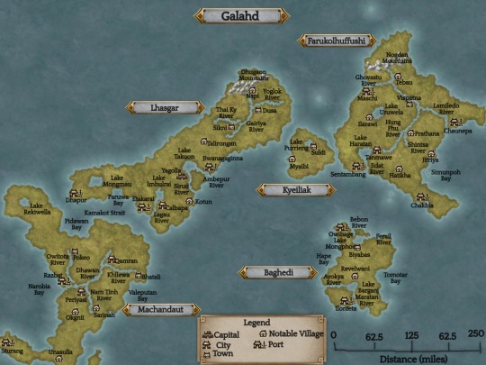

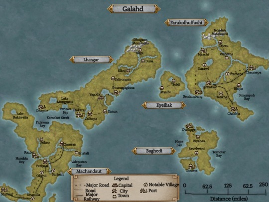
I've been writing fic for FFXV for a few years now. One of the obstacles I've run into again and again was not knowing where the characters were at all. This made it hard to plan logistics like travel time, weather, and climates. So I decided to look at what maps we have from FFXV and create my own for the lesser-traveled regions (which is everywhere except Lucis, and even that map isn't that great).
This task in itself was frustrating because it's impossible to tell where the equator and the tropics are supposed to be. The climates of Lucis and Niflheim only confuse it further. If Lucis is based on America, it's pretty far up from the tropics. Accordo doesn't appear a warm enough climate to be in the tropics, either. (Accordo has a very coastal Mediterranean climate; just a note for the future).
There has been debate regarding where Galahd is in Eos. Most agree that it is the islands located behind Insomnia. It makes the most sense because of reaction to Galahd's invasion in Insomnia's news: Niflheim conquered land in Insomnia's backyard, and were knocking at the door. When Niflheim slowly conquered much of the mainland Lucis, nothing was mentioned regarding a reaction from Insomnia.
Being where it is, Galahd should be a much colder climate than what I have it as. It should be more like Norway or Finland. However, the Kingsglaive anniversary artwork depicted a scene with a lot of South/Southeast Asian influences. The proper places of climates never seemed to matter to the developers of Final Fantasy.
In a rudimentary attempt to map the ocean currents of Eos, I drew a warm ocean current that runs westward on the north side of Galahd. This would cause the islands to have a slightly warmer climate than what it should have considering its placement. Logically, it wouldn't be warm enough to be considered subtropical, but I really wanted there to be a jungle climate in FFXV and I think that's what the developers originally intended as well.
On the southern coasts of Galahd, there is a cool ocean current that runs westward. These waters are much calmer and are ideal spots for large fishing enterprises. The warm ocean current in the north brings storms and a lot of rain; the north side of the islands are much wetter.
The climates I described in the climate map are classifications that can be found on Wikipedia. I tried sticking close to climates found in Southeast Asia, while also giving some more temperate areas as well. While much of the material culture is SE Asian, there are some things, such as the braids Nyx and Lib wear, that seem to stem from ancient Indo-European/Iranic influences. There was a custom among one of these people in which only warriors braided their hair.
For place names, I used fantasynamegenerators.com and selected random South/Southeast Asian town names. There are two straits, the oceans, and the seas that I haven't named yet. The map became very cramped with one names I already put on it.
Some headcanons I came up with while working on this:
Galahd's climate provides some challenges to the transportation infrastructure. There is no major roadway nor any major settlement on the north edge of Lhasgar due to the dense forest and the risk of annual floods. Cities and towns are more firmly established further in the island.
When Lucis still controlled the islands, they attempted to improve the infrastructure by establishing major roads and railways. The climate did not allow much leeway for railway, however. Around the same time, Lucis relaxed its control over Galahd and allowed for autonomy.
The most common forms of transportation are by vehicle, bus, or boat along the waterways.
There are cities and towns. These were there before Lucis took over, although they had looked much more traditional back then. Most of the world believes Galahd to be a couple of islands full of small backwoods villages, but they were as sophisticated as any other culture at the time they were conquered, and modernized with everyone else. While modernizing, Galahd had also managed to stick with their traditional culture.
While the map looks crowded, there is still a lot of open land and wilderness. The rivers and lakes shown are only the major rivers and lakes; there are more, just as there would be for any other regional map. Water and wilderness are defining features of Galahd.
The mountain ranges had once been connected, just like how the Appalachian and the Little Atlas Mountain Ranges.
Feel free to use these maps when writing your own fics or headcanons! I would greatly appreciate being credited. These maps are just my interpretation, and don't stand in for canon material. They are flawed, but I worked with what I had. I made these using Inkarnate.
95 notes
·
View notes
Text

Where is Calabria?
Calabria is the southernmost region of the Italian peninsula, between the blue Ionian and Tyrrhenian Seas and separated from the island of Sicily by the Strait of Messina.
Calabria only shares a border with Basilicata to the north, but Sicily lies a short two miles off Calabria's tip.
One of the least explored and at the same time one of the most rewarding regions of Italy, Calabria is a region of often spectacular scenery and unspoilt landscapes justifiably renowned for its fine food and rich culinary traditions.

There are also fine towns such as beautiful seaside Tropea, while the lungomare of the bigger city of the region, Reggio Calabria, has been called the most beautiful in Italy.

Calabria has the wildest mountain ranges on the Italian peninsula – indeed some of the wildest and most remote in Europe. Byzantine monks escaping persecution flocked to the mountains of Calabria throughout the medieval period, founding remote hermitages and monasteries such as the dramatically sited Cattolica di Stilo along with several hidden gems in the river valleys of the Pollino National Park.
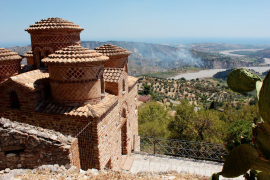
The Greek temples and theatres of Sicily may be better known, but it is in Calabria that the influence of Greece on Italy really becomes tangible. Where else in Italy are there villages where Greek is still spoken, and where goat and lamb are roasted in a pit – a practice that would have been familiar to the ancient Greeks? Pythagorus lived here, and the sea monster Scylla – who ate most of Odysseus’ crew — had her cave here.
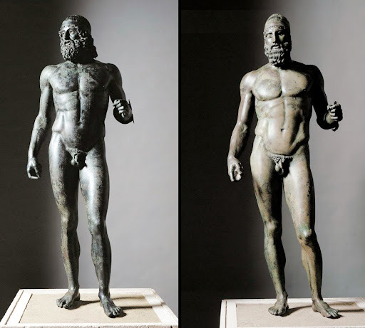
The Riace Bronzes are arguably two of the finest Greek bronze statues to survive anywhere, while the ancient Greek settlement of Locri was founded when the Locrians were banished from Greece ‘because of the scandal caused by their noblewomen’s indiscriminate love affairs with slaves’. Locrians insisted on strictly matrilinear succession – and was one of the only known matriarchies in ancient Greece.

Follow us on Instagram, @calabria_mediterranea
#calabria#italy#italia#southern italy#south italy#mediterranean#mediterranean sea#sea#mountains#mountainscape#seaside#seashore#seascape#beach#beaches#history#magna graecia#ancient#ancient greece#locri#tropea#reggio calabria#bronzi di riace#stilo
28 notes
·
View notes
Text
In the waters of the South China Sea, Chinese coast guard vessels have clashed with Philippine ships. In the air above the Taiwan Strait, Chinese warplanes have challenged Taiwanese jet fighters. And in the valleys of the Himalayas, Chinese troops have fought Indian soldiers.
Across several frontiers, China has been using its armed forces to dispute territory not internationally recognized as part of China but nevertheless claimed by the Chinese Communist Party (CCP).
In August 2023, Beijing laid out its current territorial claims for the world to see. The new edition of the standard map of China includes lands that are today a part of India and Russia, along with island territories such as Taiwan and comprehensive stretches of the East and South China Seas that are also claimed by Brunei, Indonesia, Japan, Malaysia, the Philippines, and Vietnam.
China often invokes historical narratives to justify these claims. Beijing, for example, has said that the Japanese-administered Senkaku Islands, which it claims under the name of the Diaoyu Islands, “have been an inherent territory of China since ancient times.” Chinese officials have used the same words to back China’s right to parts of the northeastern Indian state of Arunachal Pradesh. The Chinese government also claims that its sovereignty over the South China Sea is based on its own historic maritime maps.
However, in certain periods since ancient times China has also held sway over other states in the region—Mongolia, North Korea, South Korea, and Vietnam. Yet Beijing is currently not laying claim to any of these.
Instead, Beijing has embraced a selective irredentism, wielding specific chapters of China’s historical record when they suit existing aims and leaving former Chinese territories be when they don’t. Over time, as Beijing’s interests and power relations have shifted, some of these claims have faded from importance, while new ones have taken their place. Yet for Taiwan, Chinese claims remain unchanged, as the fate of the island state is tied to the very legitimacy of the CCP as well as the vitality of Chinese President Xi Jinping’s political vision.
Many of the CCP’s territorial claims have roots in the 19th and 20th centuries during the late rule of the Qing Dynasty. Following diplomatic pressure and repeated military defeats, the Qing Dynasty was forced to cede territory to several Western colonial powers, as well as the Russian and Japanese empires. These concessions are part of what are known in China as the “unequal treaties,” while the 100 years in which the treaties were signed and enforced are known as the “century of humiliation.” These territorial losses eventually passed from the dynasty to the Republic of China and then, following the Chinese Civil War, to the CCP. As a result, upon the CCP’s establishment of the People’s Republic of China in 1949, the new Chinese state inherited outstanding territorial disputes with most of its neighbors.
But despite the humiliation the Qing Dynasty’s losses had caused, the CCP proved willing to compromise and reduce its territorial aims during times of high internal unrest. Following the Tibetan uprising in 1959, for instance, the CCP negotiated territorial settlements with countries bordering the Tibet region, including Myanmar, Nepal, and India. Similarly, when unrest rocked the Uyghur region in the 1960s and ‘90s, Beijing pursued territorial compromises with several bordering countries such as Afghanistan, Kazakhstan, Kyrgyzstan, and Tajikistan. In the aftermath of the Great Leap Forward in the early 1960s and the 1989 Tiananmen Square Massacre, the CCP also pursued territorial settlements with Mongolia, Laos, and Vietnam in the hopes of securing China’s borders during times of domestic instability. Instead of pursuing diversionary wars, the CCP relied on diplomacy to settle border and territory disputes.
But China has changed quite a lot since then. In recent years, the CCP has avoided the inflammatory domestic political chaos of previous decades, and its once-tentative hold over border regions, such as Tibet and the Uyghur region, has been replaced by an iron grip. With this upper hand, the CCP has little incentive to pursue peaceful resolutions to remaining territorial disputes.
“China’s national power has increased significantly, reducing the benefits of compromise and enabling China to drive a much harder bargain,” said M. Taylor Fravel, a political science professor at the Massachusetts Institute of Technology.
In this context, the CCP has expanded its irredentist ambitions. After the discovery of potential oil reserves around the Senkaku Islands, and the United States’ return of the islands to Japan in the 1970s, Beijing drew on its historical record to lay claim to the islands, even though it had previously referred to them as part of the Japanese Ryukyu Islands. Similarly, though Beijing and Moscow settled a dispute over Heixiazi Island, located along China’s northeastern border, in 2004, the 2023 map of China depicted the entire island (ceded, along with vast Pacific territories, by the Qing Dynasty to the Russian Empire in 1860) as part of its domain, much to the ire of the Russian Foreign Ministry.
Collin Koh Swee Lean, a senior fellow with the S. Rajaratnam School of International Studies at the Nanyang Technological University in Singapore, argues that the Chinese mapping of Heixiazi Island shows that Beijing holds on to certain core interests and simply waits for the opportune time to assert them.
“Given the current context of the war in Ukraine and Russia’s increased dependence on China, it might have appeared to Beijing that it has the chips in its pockets because, after all, Moscow needs Beijing more than the other way around,” Koh said on the German Marshall Fund’s China Global podcast.
This raises the question of whether territorial disputes that were settled during times of CCP weakness can be revisited and become subject to irredentist ambitions should power balances shift in China’s favor.
According to Steve Tsang, the director of the China Institute at the University of London’s School of Oriental and African Studies, there is currently a limit to how far the CCP will push territorial claims against Russia, since President Xi will need Russian support to sustain his grand ambitions for Chinese leadership on the global stage.
Although it would be a long shot, even Russia may not be safe from these ambitions indefinitely. Given that large swaths of Russia’s Pacific territories were part of China until 1860, “China could claim back the Russian Far East when it deems the time is right,” Tsang said. Such control would grant Beijing unrestricted access to the region’s abundance of coal, timber, tin, and gold while moving it geographically closer to its ambition of becoming an Arctic power.
While there is plenty of historical evidence pointing to former Chinese control over the southeastern portion of the Russian Far East, the historical record is less unequivocal about Chinese control over Taiwan. Anything resembling mainland Chinese control over Taiwan was not established until after 1684 by the Qing Dynasty, and even then central authority remained weak. In 1895, the Qing Dynasty ceded Taiwan to the Empire of Japan following the First Sino-Japanese War, and by the time Chinese authority was restored in 1945, Taiwan had undergone several decades of Japanization.
These details have not prevented the CCP from claiming that Taiwan has been an inalienable part of China since ancient times. Yet more than any other irredentist claim, Xi has made unification with Taiwan a major component of his vision to rejuvenate the Chinese nation.
Unification, however, has little to do with ancient history and more to do with the challenge that Taiwan presently poses to Xi’s aims, according to Chong Ja Ian, an associate professor who teaches about Chinese foreign policy at the National University of Singapore.
“The CCP pursues a Chinese nationalism that emphasizes unity and homogeneity centered around the CCP leadership while they also often claim that their single-party rule is acceptable to Chinese people,” Chong said.
In contrast, Taiwan holds free elections in which multiple political parties compete for the favor of a people that have increasingly developed an identity distinct from mainland China.
“The Taiwanese experience is a clear affront to the CCP narrative,” Chong said.
Control over Taiwan is also attractive to Beijing because it is key to unlocking the Chinese leadership’s broader ambition of maritime hegemony in waters where almost half of the world’s container fleet passed through in 2022.
As with the case of Taiwan, the CCP’s historical arguments regarding its claims on island groups and islets in the East and South China Seas are likewise much weaker than many of its land-based claims.
Instead, Chinese territorial intransigence in the maritime arena is more about a strategic shift in the value of the seas around China, Fravel said.
Today, it has been estimated that more than 21 percent of global trade passes through the South China Sea. And beneath these waters are not only subsea cables that carry sensitive internet data but also vast estimated reserves of oil and natural gas.
Although it may say otherwise, Beijing’s unwillingness to let up on its tenuous territorial maritime claims suggests that China is pursuing long-held ambitions and global aspirations rather than attempting to reverse past losses. So long as the CCP wields its historical record selectively and changeably to serve its aims—and is willing to back its claims up with military action—China’s neighbors will remain at risk.
20 notes
·
View notes
Note
This might not be your area of expertise but do you know anything about the “land bridge” theory that claims that indigenous people got to the so called Americas by a frozen land bridge between Russia and Alaska? Idk if it’s just me but I’ve always felt that theory was always used as a way to be dismissive towards indigenous peoples.
Yeah, it definitely is not my area of expertise. There's a whole history of the theory being pushed and opponents being belittled that I don't really know. I think most Americans probably still don't know that it's discredited, and probably fewer know what was wrong about it beside being merely incorrect. I don't really want to get into it much because, like I said, the theory has its own history that I don't know well enough to talk about.
I will add a little clarification though, because some people reading this will probably be surprised to learn that the Bering Strait land bridge theory (that all of the Indigenous peoples of the Americas descend from a group who crossed the Bering Strait from northeast Asia some 13,000 years ago) is discredited. Many Indigenous people have always objected to this, for a variety of reasons but including that it conflicts with their oral histories. The academic consensus has finally caught up in recent decades as discoveries have been made of settlements (in areas extremely far from Alaska, no less, as far south as so-called Chile) predating the time when the land bridge would have been passable. The current scientific consensus is that there isn't a single event or explanation, and some of the oral histories that were previously regarded as unsuitable for determining truth have been vindicated. In particular, some nations' histories include an arrival on the continent over the ocean, which western academics used to consider impossible on grounds of Indigenous people not being advanced enough, which is a bunch of racist horseshit. While they now no longer represent the consensus, there are still holdouts still pushing to discredit the evidence of earlier settlement (the "Clovis First" theory). I also want to add that while the scientific consensus has come to overlap with some Indigenous oral histories, vindicating those oral histories in the process, oral history isn't important and valuable because it turns out to be "true" in a way understood by western history; that's still only granting legitimacy on a contingent basis in situations where correspondence to western notions of truth and history just aren't the point.
People who know more, feel free to add. I don't feel qualified to talk about it much more but I do encourage people to look into it themselves.
A little bit of a side-note but heathens following me will be interested to know that the Kinnewick man, about whom Steve McNallen had a very public racist tantrum trying to prove he was an ancestor of white people, is implicated here. The controversy came about because the Kinnewick man's physiology did not conform to what was predicted by the land bridge theory (note: this was three years after Trump's "They don't look like Indians to me" testimony). After violating the wishes of the Kinnewick man's actual descendants and subjecting the remains to intense study and genetic testing it predictably turned out that he was in fact an ancestor of still-living Indigenous people and those archaeologists should have kept their hands off, like they had been told.
480 notes
·
View notes
Text
British presence in the Straits Settlements […] (Penang, Singapore and Melaka) as a whole opened the way […]. Governor Andrew Clarke [...] clearly intended that economic botany should follow the quest for tin. Hardly three months after the [signing of the treaty legitimising British control in Malaya] [...] the Governor pressed Lord Carnarvon, Secretary of State for the Colonies, himself a keen botanist and collector, for the services of a ‘scientific botanist’. [...] Intimate plant knowledge among local [people] [...] assisted the discovery of many [plants valuable to European empire] [...] and the absorption of a number of vernacular names such as kempas (Koompassia), pandan (Pandanus) and nipah (Nypa) into scientific nomenclature. Equally, indigenous names for timbers, pre-eminently meranti and cengal, attained the status of trade names on the international market. Malay knowledge [...] proved also invaluable for commerce and [...] industries.
The Great Exhibition of 1851 at the Crystal Palace in Hyde Park, which displayed representative samples of colonial resources, was a microcosm of empire. Empire [...] co-sponsored the surveying, mapping and inventorying of people, lands and products for the ends of imperial power. Tropical nature, once a source [...] of wonderment, was brought to the domestic market place.
High on the imperial economic agenda were the Malayan territories, the source of gutta percha (from Palaquium gutta). Ingeniously adapted by the Malays [...], the plastic qualities of gutta percha were investigated for medical and industrial use by the [English East India] Company surgeons, T. Mongtomerie (1819-43) and T. Oxley (1846-57). [...] At the same time Oxley successfully pioneered the use of gutta percha for plastering fractures and preserving vaccine, the latter hitherto unable to be kept even for a few days. When a Prussian artillery Officer [...] then perfected its use for insulating telegraph cables, the product immediately gained strategic importance for the empire. Similar adaptations of other indigenous uses of plants paid dividends to industry and agriculture. [...]
---
The emergence of Hevea rubber in the Peninsula, superseding gutta percha as an industrial product was, again, the result of scientific exchange within the close-knit colonial botanical network [...] [following] [t]he illegal exportation by Kew [Royal Botanic Gardens in London] of the seedlings from South America to Ceylon and the Singapore Botanic Gardens [...]. Out of the seedlings sent in 1877 to Singapore, seven were planted by Hugh Low in the Perak Residency Garden. These and those raised in the Botanic Gardens furnished the seeds for the first plantations.
Though an introduced species, indigenous knowledge [...] of a wide variety of gums and exudates [...] benefited the plantation industry.
This [...] scored a major triumph for the colonial plantation industry. [...]
Large areas of Melaka had already been laid to waste by [...] a fast-growing variety of Brazilian cassava introduced in 1886 by Cantley.
The same cultivators soon turned the Imperata grasslands to rubber, but its rapid spread meant that a number of native plant species either became very rare or were entirely exterminated. The wild ancestor of the domestic mangosteen (Garcinia mangostana) is a likely example. [...] During his visit to Singapore in 1854 Wallace identified, within just a square mile, some 700 species of beetles [...].
---
All text above by: Jeyamalar Kathirithamby-Wells. "Peninsular Malaysia in the context of natural history and colonial science." New Zealand Journal of Asian Studies Volume 11 Number 1. 2009. [Bold emphasis and some paragraph breaks/contractions added by me.]
#abolition#ecology#plantations#imperial#colonial#tidalectics#extinction#archipelagic thinking#victorian and edwardian popular culture#intimacies of four continents
56 notes
·
View notes
Photo
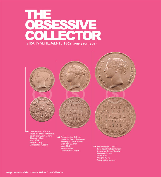
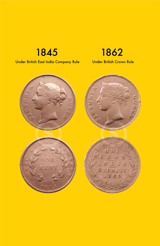
In 1862, the reverse side of the coins was changed to reflect the transfer of power from the British East India Company to the British Crown due to the Government of India Act of 1858 which led to the formation of the British Raj.
In accordance with the Government of India Act of 1858, the government of the Straits Settlements (Malaysia, Penang, Malacca, Singapore) was taken over from the East India Company by the British Crown through the British Raj in India.
The obverse of the three coins remained the same.
#india#british east india company#malaysia#straits settlements#british empire#numismatic#coincollecting#collecting#coin
0 notes
Text
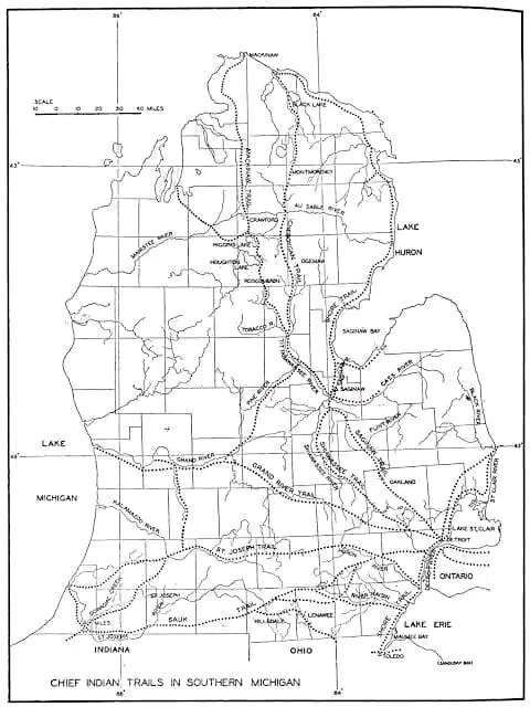
Michigan's first trails were not made by native Americans but ranging buffalo herds in migration. This was especially true on the St. Joseph trail in Southwest Michigan. The major trails in lower Michigan tended to link Indian settlements of Mackinac, Detroit, Saginaw, and Niles. The area around Saginaw had the most native American settlements in the Great Lakes region.
Noted below are native trails that we travel everyday.
Shore Line Trail - A minor trail starting near Toledo and hugging Lake Erie's shore, the Straits of Detroit. Past Fort Gratiot and Lake Huron to a spot near White Rock. White Rock was considered a solemn spiritual place of offering. Today this route is mirrored by Lakeshore Drive from Detroit to Lexington and M-25 north. This trail continues north along the entire shore to Cheboygan. It was considered a minor trail as travel via canoe was preferred along this route. Michigan chose to utilize much of the original Native American trail along Lake Huron and Saginaw Bay to create M-25. Paving of Michigan's First Scenic Highway was started in 1933 and completed in 1940.
Saginaw Trail - One of the oldest trails, this Sauk trail system, went from the Straits of Detroit to Saginaw. Today this starts at the Detroit River and heads northwest up Woodward Avenue to Pontiac, then continues up Dixie Highway through Flint to Saginaw.
Sand Ridge Indian Trail - An ancient trail from Saginaw to Port Austin in Michigan's Thumb. Used primarily for access to the rich hunting ground of the Thumb. Today, M-25 follows much of the same route. However, the old trail is still evident and marked as Sand Road in Huron County. A major canoe passage across Saginaw Bay occurred at Oak Point via Charity Island to reach the AuSable River.
St. Joseph's Trail - A major east-west system called Route du Sieur de la Salle and the Territorial Road. When the Territorial road was first built from Plymouth to St Joseph, a portion of the road was ‘corduroy.’ which means wood lo
15 notes
·
View notes
Text

Tamil Diasporas across the Bay of Bengal
1 note
·
View note
Text
OPINION: The national hui at Tūrangawaewae Marae saw 10,000 people united in the face of actions by the coalition government, including its proposed Treaty Principles Bill. John Campbell was there.
History happens on single days.
Yesterday, at Tūrangawaewae, will be one of them.
“Why are you here?”, I asked Tame Iti.
“Vibrations”, he replied.
The rest of us will feel them over the days and months and years ahead.
Initial estimates of how many people would come had begun at 3000. Then 4000 registered, so estimates grew to 5000. Then 7000. By lunchtime, organisers were saying 10,000 had arrived. There wasn't room inside for them all. A large marquee across the road was full, all day. Every seat, everywhere, was taken. There was hardly standing room.
This special place, which has held tangi for royalty, which is where the Tainui treaty settlement was signed, which was visited by Nelson Mandela, and Queen Elizabeth II, and many of our greatest rangatira, has seldom seen so many people.
But no one objected. To standing. To the steaming heat. To the fact that sometimes people were too far away from the speakers, or the screens relaying them, to hear.
New Zealand First’s deputy leader, Shane Jones, told RNZ the hui could turn into a “monumental moan session”.
But it didn’t. Somehow, the word I keep coming back to is joyful.
The National Hui for Unity it was called. And it felt like exactly that.
On the way to Ngāruawāhia early yesterday morning, I pulled into a truck-stop near Bombay, at the southernmost end of the Auckland motorway system, to meet the Ngāpuhi convoy travelling down from the far north.
Some had begun their journey way up, in Kaikohe, at 3am. They spilled out into the half light of an overcast morning and inhaled the beginning of what would be an extraordinary day.
It’s easy for the significance of this delegation to be lost amid all the other arrivals. The people who’d come from even further away. Iwi after iwi. Ngāpuhi, Ngāti Porou, Tainui, Ngāti Kahungunu, Ngāi Tahu, Te Arawa, Ngāti Tūwharetoa, Ngāi Tūhoe, Ngāti Maniapoto – the big ten, all there, in declaratory numbers.
Just a few members of the Ngati Porou contingent who drove over on Friday from Tairāwhiti to attend the hui.
Ngāi Tahu representatives had taken a huge journey by road, then Cook Strait ferry, then road.
A friend’s father flew up from Invercargill.
But the size and standing of Ngāpuhi’s delegation provides some insight into how very significant this hui was.
Ngāpuhi aren’t a Kīngitanga iwi. They don’t see Kīngi Tūheitia as their king. And they contain Waitangi within their broad, northern boundaries – home, of course, to the Waitangi commemorations, our most famous form of national hui.
And yet they came, hundreds of Ngāpuhi. Some wearing korowai made especially for the occasion. Some the direct descendants of Treaty signatories. A waiata, composed for the hui, rehearsed beyond newness into a heartfelt and singular voice.
“Why are you going?” I asked Mane Tahere, the chair of Te Runanga-Ā-Iwi-Ō-Ngāpuhi. “It feels significant that Ngāpuhi are attending in such numbers.”
“Because”, he answered, “the challenges we face do not discriminate amongst iwi. We held three hui to discuss whether we should come, and who would come, and what our message would be. The final hui was only last Saturday. I wouldn’t have put our rūnanga resources into something we didn’t collectively support. This was hapū rangatiratanga. Hapū after hapū spoke and said we should go.”
Why?
“Because the question we have to ask as Māori is how we activate ourselves, re-activate ourselves, for 2024? How do we say to the coalition government, ‘hang on, what do you mean, and what are you doing?’ And the best way to do that is to do it together. Now is the time for Māori unity.”
The National Hui for Unity was only called by Kīngi Tuheitia Pootatau Te Wherowhero VII (Kīngi Tuheitia) at the beginning of December. That so very many people would arrive here, only six weeks later, in the holiday-season slowness of the third week of January, speaks not only to how resoundingly those present reject the coalition government’s Treaty Principles Bill, but also to a strength of unity already existing.
That is to say, a unified rejection of what Kīngitanga Chief of Staff, Archdeacon Ngira Simmonds, described as the “unhelpful and divisive rhetoric” of the election campaign.
“Maaori can lead for all”, said Ngira Simmonds, at the beginning of this month, “and we are prepared to do that.” *
This is part of a growing sense, as Ngāpuhi’s Mane Tahere told me, that “we’ve turned a corner”.
The corner is that u word – unity. The increasingly urgent sense of the need for a collective response to the coalition government.
And, without great external fanfare, these relationships have already been building.
The Kīngitanga movement has begun sending some of its most senior figures north for Waitangi Day commemorations – into the heart of Ngāpuhi country. And again, like Ngāpuhi coming to Ngāruawāhia, this reflects a belief that by Māori for Māori, all Māori, is the strongest possible response to a government they fear is intent on division.
This year, for the first time since 2009, Kīngi Tūheitia himself (who has Ngāpuhi whakapapa on his father’s side) will be attending Waitangi.
Symbolic? Yes.
Significant? Yes.
Unity.
Mana motuhake (self-government).
“Look at all these people,” Tame Iti said to me. “They’re here to listen. To learn. The first layer of mana motuhake is yourself.”
All protest is a form of risk.
Risk that it goes awry – and costs support, rather than galvanises it.
Risk that it arms your most cynical critics with the material for derision or contempt.
Risk that no one notices. Or that the turnout is so small that those who have the luxury of being able to not protest can turn away.
Some politicians may tell you that 10,000 people is not very many. I would say otherwise. In 30 years of covering politics, I have never attended a New Zealand party-political rally that attracted anywhere near that many. Or even half that number.
What happened at Tūrangawaewae yesterday was a triumph for all those involved.
In the striking heart of the mid-afternoon, I passed Tukoroirangi Morgan, the chair of the Waikato-Tainui executive board. We were going in opposite directions over the sunburnt road.
Chair of the Waikato-Tainui executive board Tukoroirangi Morgan.
Chair of the Waikato-Tainui executive board Tukoroirangi Morgan. (Source: 1News)
“How’s it going, Tuku?”, I asked him.
“It’s amazing”, he replied. “All these people.” And then he stopped, looked out over the everyone, everywhere, and repeated himself. “Amazing.”
Tūrangawaewae is located just outside Ngāruawāhia, directly across the Waikato River from the shops in that little township. Somewhere, just to its east, the new Waikato Expressway has stolen many of the estimated 17,000 cars a day that once passed through here. For decades, Ngāruawāhia was a pie and petrol stop on the main road between Hamilton and Auckland.
Not so much, any longer.
The challenge of history is to survive it.
And Kīngitanga itself was a kind of survival strategy.
It wasn’t this simple, of course, but a famous saying of the second Māori King, Tāwhiao, broadly speaks to the hopes of the Kīngitanga movement: “Ki te kotahi te kākaho ka whati ki te kāpuia e kore e whati.” The Māori Dictionary translates it prosaically: “If there is but one reed it will break, but if it is bunched together it will not.”
Yesterday, the reeds felt tight and strong.
“Why are you here?” I asked people, over and over.
The answer was almost always a variation of what Christina Te Namu told me. Christina, too, is Ngāpuhi. “I just wanted to support our people”, she said. “Now is the time for us to stand together as one.”
A group of women from Ngati Porou stopped to say kia ora.
It seems almost inadequate to state it like this, but they were there to be there. They had driven from Tairawhiti because being there mattered. Every person I spoke to had come to be part of this declaration of solidarity.
'An attempt to abolish the Treaty'
On Friday morning, something happened that gave this already significant day a vivid, extra weight.
My 1News colleague, Te Aniwa Hurihanganui, obtained details of the coalition Government’s Treaty Principles Bill. In its initial form it is not so much a re-evaluation of the role of the Treaty as an abandonment of it. Professor Margaret Mutu, speaking on 1News on Friday night, called it “an attempt to abolish the Treaty of Waitangi.”
This has arisen out of National’s coalition agreement with ACT.
I wrote about this at the end of last year, and also in the weeks after the election. I looked at the coalition agreements between National and ACT, and National and New Zealand First. And I noted their pointed focus on Māori. Some of it felt mean. What I called a strange, circling sense of a new colonialism.
I wrote about what I saw as ACT and New Zealand First's experiments with a kind of "resentment populism".
Who are we?, I asked. And where are we heading?
We’re heading to National reaching 41 percent in the first political poll of the year, “a massive jump”, as Thomas Coughlan described it in the NZ Herald, earlier this week. And we’re heading here, to Tūrangawaewae, and to thousands of people who travelled from throughout the country to collectively say, “no”.
In other words, we’re heading towards, or have already arrived in the vicinity of what PBS called the “divide and conquer populist agenda”.
And we’re heading to politics that purport to speak out against division, whilst arguably fomenting it.
In an opinion piece by David Seymour, published in the NZ Herald on Friday, the ACT leader begins with the sentence, “If there’s one undercurrent beneath so much of our politics, it’s division”.
Is David Seymour responding to division, or causing it?
The Treaty, he said, in December, “divides rather than unites people, as most treaties are supposed to do.”
But whose endgame is division? Really?
I've written before about the kind of populist politics that drive people to division, then throw up their hands and yell, “LOOK! DIVISION”, having wished for exactly that.
This, as Australian Academic Carol Johson wrote in The Conversation after the “no” vote in Australia’s Voice referendum, speaks to “a conception of equality controversially based on treating everyone the same, regardless of the different circumstances or particular disadvantages they face.”
That's equality as David Seymour consistently claims to define it.
But do as they say, not as they do. There was a time when ACT received some handy support from National. Remember that famous cup of tea? Surely Seymour's idea of equality would have insisted that Act get trounced than receive a leg-up?
The fascinating thing is that populism is typically structured around “the claim to speak for the underdog and the critique of privileged 'elites' and their disregard for the needs of ’ordinary people’".
But it’s hard for National to occupy that space when the party has historically been supported by the “elite”, and when your leader is a former CEO who owns seven properties, and who received total remuneration of $4.2 million in his last full year at Air New Zealand.
So, you can do two things. You can outsource populism to your coalition partners. (And sit there with a face of injured innocence, like someone insisting it was really the dog who farted.) And you can allow coalition partners to redefine the definition of “elite”.
No-one does this more enthusiastically than Winston Peters.
During the months prior to the election, the New Zealand First leader said “elite” more often than Kylie Minogue has said “lucky”.
“Elite Māori”, “elite power-hungry Māori”, “an elite cabal of social and ideological engineers.”
The idea, as I wrote after the election, is to somehow persuade us that Māori are getting something the rest of us are not. And they are: a seven-years-shorter life expectancy, lower household income, persistent inequities in health, the greatest likelihood of leaving school with low or no qualifications, and an over-representation in the criminal justice system to such a great extent that Māori make up 52 percent of the prison population.
Elite as.
So, had this hui erupted into a kind of rage, would that have been a victory for populism? Would the divisions have become entrenched? Would Māori have been blamed for reacting to provocation, rather than the provocation itself being examined?
None of this is new. Which is why Māori recognise it.
In July 1863, the Crown issued a proclamation demanding: “All persons of the native race living in the Manukau district and the Waikato frontier are hereby required immediately to take the oath of allegiance to Her Majesty the Queen”.
And those who wouldn’t?
“Natives refusing to do so are hereby warned forthwith to leave the district aforesaid, and retire to Waikato beyond Mangatawhiri.”
And anyone “not complying with this Order… will be ejected.”
Vincent O’Malley, in his remarkable book The Great War for New Zealand describes what happened next.
“On the same date some 1500 troops marched from Auckland for Drury.”
The troops didn’t stop. There are few more egregious and cynical predations in our history. South they went. Without just cause or provocation. Into Waikato.
Ngāruawāhia, Vincent O’Malley tells us, was “strategically important during the war because of its location at the confluence of the Waikato and Waipā rivers.”
“By 6 December 1863, Ngāruawāhia (‘the late head quarters of Māori sovereignty’ as one reporter dubbed it) had been deserted.”
At four o’clock that afternoon, a British flag was hoisted there.
And why does this story matter, still? 160 years later.
Because the Crown used the requirement for “allegiance”, the demand that Māori be loyal to it, so disingenuously. The language of colonisation purported to be about governance, about the role and rule of a single law, but it was a violation of law and a betrayal of the principles of government.
By the end of this rule of law, roughly 1.2 million acres of Waikato land had been “confiscated”.
And any opposition to it was defined, in law, as “rebellion”. And rebellion was justification for seizing more land.
This is our history. And part of it happened here, where the 10,000 people met yesterday.
It was so hot by late morning that people were swimming in the Waikato River.
I wandered down from the crowds at the hui to talk to the people swimming. They were mostly young, although not all.
I met a ten year old who told me her parents had brought her so she could “find out where I’m from”.
She was from Waitara, in Taranaki, so this wasn’t a literal homecoming.
I wondered how many people had travelled big distances to have a new or reinvigorated sense of what it means to be Māori.
Heading back inside, I saw Professor Margaret Mutu.
There are few who have more rigorously applied their formidable intellect to making sense of the intersection of Māori and colonisation.
Professor Margaret Motu: "You have two parties to a treaty, and one of them can’t unilaterally redefine it."
She is of Ngāti Kahu, Te Rarawa, Ngāti Whātua and Scottish descent. She is Professor of Māori Studies at the University of Auckland. And, her university profile tells us, she holds a BSc in mathematics, an MPhil in Māori Studies, a PhD in Māori Studies specialising in linguistics and a DipTchg.
There was nowhere quiet for us to sit. But people kindly made space at the back of a kitchen prep area. And I asked her about the significance of the Treaty, for Māori, for the Crown, and for us all.
“Te Tiriti is where you go," she said. “When things look as if they’re not working for you, you have a protection, and that’s where you go. It will always look after you. It will always protect you.”
“And while it seems clear that this government wants to abolish the Treaty," Margaret Mutu continued, “that can never happen. For one thing, you have two parties to a treaty, and one of them can’t unilaterally redefine it. But also, our tūpuna were very, very wise. In the Treaty they invited Pākehā, the British, to come and live with us. But they had to live with us in peace. In peace and friendship. And that’s what the Treaty is. It’s a treaty of peace and friendship. You can’t redefine that. You can’t rewrite that. It was very wise and it was very clear.”
And here’s where Margaret Mutu helped me understand why the mood at Tūrangawaewae was so – and I wish I could find better words – hopeful, positive, constructive.
Manaaki manuhiri: to support and care for your guests.
“We invited Pākehā to live amongst us,”, she said. “And what a lot of our Pākehā friends don’t understand, I think, is that our tikanga requires us to manaaki manuhiri. And that’s about looking after everybody. Everybody. So even when we have hate thrown at us, we have to assert aroha. That’s what manaaki manuhiri requires, even when people are very badly behaved.” Margaret Mutu laughs at this. “So, people have come here today to find that strength. It’s not about fighting people. It’s to find that strength and unity to be able to rise above the hatred. And now we will just get on and do exactly that.”
After lunch, I was invited to meet the King.
I’ve never been inside Tūrongo before, the royal residence. Or Māhinaarangi, which is both a famous meeting house and a unique kind of museum.
It looks out over the marae. And it gently contains, as if nestled in the palm of a large, open hand, photos and remembrances of those who’ve come before. The people who built Kīngitanga. Tāwhiao is there, his photo looking down from the wall. He died 130 years ago. How he would have marvelled, with great pride, at such a gathering, and perhaps, also, despaired at it still being necessary, in 2024.
Ngira Simmonds took me in. And I found myself, shy for once, able to stand and look out, viewing the unfolding of this new history from a place that is so central to the story of the history of us.
Kīngi Tuheitia was beaming.
“I didn’t sleep last night”, he told me. “But I knew this was the time for us to come together. And we have. We have.”
It occurred to me, as I walked back to stand amongst the thousands Kīngi Tuheitia was looking out to, with such delight, that the hui was the actualisation of Tāwhiao’s hope for the unbreakable strength of reeds tied together.
What was was happening felt transformative in the very fact it was happening. The mana motuhake of 10,000 people.
The vibrations.
Will the government feel them?
Will they survive the divisions of populism? Of politics that echo our repeated capacity to claim we are governing to unite people whilst governing against Māori?
Or maybe, this is how it all begins. In an historically large display of unity.
Rātana follows. Then Waitangi.
Yesterday ended with Kiingi Tuheitia speaking.
“The best protest we can do right now is be Maaori. Be who we are, live our values, speak our reo, care for our mokopuna, our awa, our maunga, just be Maaori. Maaori all day, every day. We are here, we are strong.”
The reeds tightening.
*Macrons haven't been used when quoting Tainui, who choose not to use them.
fantastic article on the national hui in response to aotearoa’s assault on indigenous rights. click through for pictures and video.
#new zealand#aotearoa#nz#nzpol#news#politics#indigenous rights#maaori#maori#land back#david seymour#waitangi#long post
33 notes
·
View notes
Last Seen Blogs

sejs-obsessions
Sej

teendominator
Bez tytułu

candidlove1
Untitled

milfcodeddean
Not Active Or Inactive But A Secret Third Thing

queennicoleinboots
The misadventures of Queen Nicole In Boots