#just the gulf coast marshes
Text
Just Sam and Bucky, driving the hour from Delacroix to the docks. It’s a relaxing, winding drive in Sam’s truck as they listen to the Trouble Man soundtrack. They hold hands whenever Sam stops the car.
#sambucky#the daily sambucky fluff diary#sam wilson#bucky barnes#sambucky headcanons#domestic fluff#sam wilson headcanon#bucky barnes headcanon#just the gulf coast marshes#and the easy drive#and the relaxing tones of marvin gaye#my headcanons
54 notes
·
View notes
Text
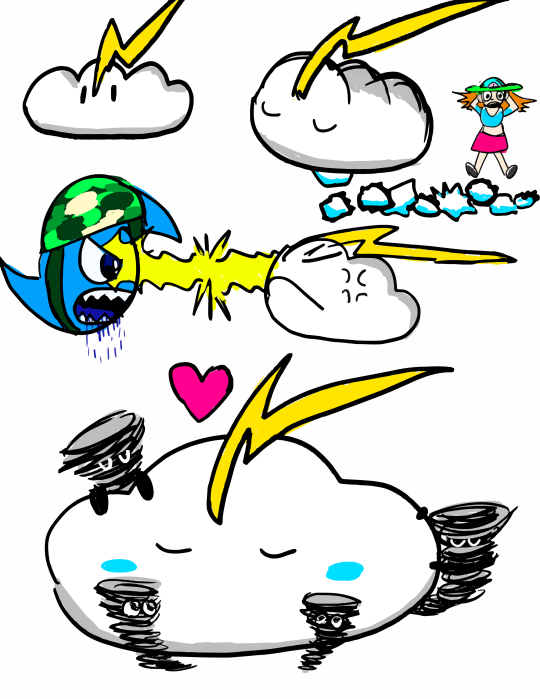
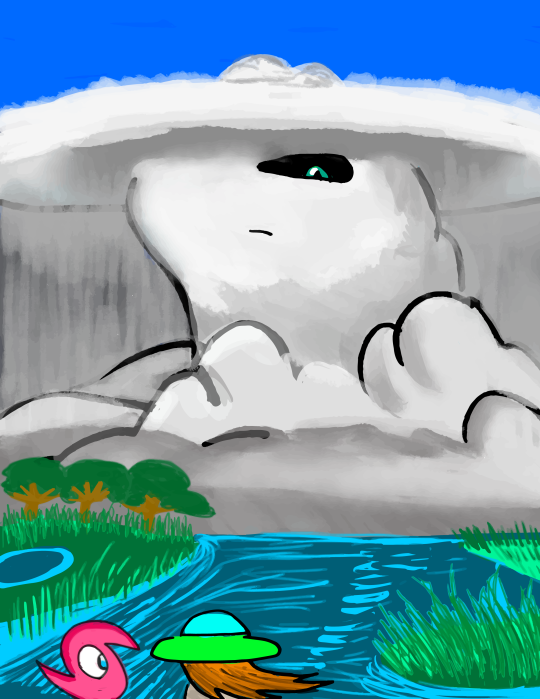
MELISSA AND THE ALLIES OF GAIA ART DUMP 1 - THE SUPERCELL
In episode 9 of the story "Melissa and the Allies of Gaia" I posted on Wattpad in August, Melissa and her storm avatar partner Hurricane Carla (shown in her miniature form) face off against a sapient high-precipitation supercell over a salt marsh in Alabama. A pair of fisherman have been using the tornadoes/waterspouts it creates to catch fish, having used an artifact of evil weather magic to take control of the storm.
Since actually moving to Alabama (I had no idea I would end up there at the time I wrote the story chapter) I have kind of developed a new fondness for this character. Most of the characters in the story I have done art previously for but I have never drawn this one.
While I don't specify this in the story, I imagine this supercell to use she/they pronouns (insert mammatus cloud joke here) and the tornados are like her "children" that she lets out to "play" (I mean if you scaled up a toddler to the size and strength of a tornado you'd probably get as much destruction). I plan for her to come back in a sequel, though of course Melissa will end up calling her something like "Mr. Thunders." (not that I imagine she would care all that much, of course, being a giant storm and all).
Like the hurricane avatars, she has a miniature form (shown in the top image) that she stays in when conditions aren't right for her to build up her massive supercell body. It looks like a cute little cumulus cloud with a thunderbolt crest. She doesn't speak any human language, and in the story she only briefly speaks in the wind language of storms to Carla, so she isn't very talkative. For this reason I imagine Melissa might one day try to keep her as a pet, which of course goes terribly wrong (as you can see in the first page with "Mr. Thunders" pooping huge spiky hail all over her apartment ["Mr Thunders! Not on the car!"]).
Shown in the top image is also her standing off against the miniature form of Labor Day and glaring at him with lightning. This happens in the story because Labor Day gets really hungry after the wind shear causes dry air to be entrained in his circulation and he basically loses control for a brief moment and tries to eat her waterspouts. Needless to say "Mr. Thunders" doesn't like this one bet, and attacks Labor Day. Fortunately it turns out "Mr. Thunders" also is hungry for some warm moist air too and they end up just kind of returning to Gulf Coast Headquarters and having lunch on some tropical air from the Gulf of Mexico.
The final drawing on the first image shows them snuggling with their tornado children. Ultimately I imagine she only wants what is best for them. It just so happens that sometimes what is best for a tornado isn't what is best for humans.
Some more notes on her design:
-Since she's a high precipitation supercell I imagine she has a lot of precipitation falling both from her anvil and from her base, which obscures anything like the wall cloud etc. This also conveniently means I don't have to draw all the features in the base of the supercell because I can't make heads or tails of how they are arranged lol (you can tell I have more experience with tropical cyclones)
-I basically imagined her thunderhead anvil is like her hat. It actually extends far ahead of and behind her head (it is extended by the upper level wind shear) but since she's viewed from the front it is foreshortened. From the side it would be quite long.
-Her eye color is supposed to be the deep green seen in storms with a lot of hail as the sun sets. I imagine her triangular pupil actually looks like a conical tornado up close.
-I had previously in the webcomic drawn Melissa as having a peace sign beanie or skullcap, but I realized when writing the story that that sort of hat doesn't make sense for her home of Galveston, which has a hot climate. I imagine it's more of a sunhat now. (Okay this isn't about the supercell's design but I think it's important)
#character designs#meteorology#supercell#storm#cloud#thunderstorm#tornado#waterspout#hurricane#tropical cyclone#weather#sky
5 notes
·
View notes
Note
You’re a water sign, so are you good at swimming
I know how to swim and enjoy it on occasion, though it's not something I do regularly. The last time I had the opportunity was a few months ago in the autumn, when a lover and I attended a naked pool party. The trouble is that, contrary to what a map might suggest, Louisiana doesn't really have beaches in the recreational sense. Its extensive coastline mostly consists of shifting, half-flooded marsh that drops off into the Gulf after a point. As such New Orleanians looking to swim either have to use artificial pools or go east along the coast - and the further you go that way, the better the beaches but the more obnoxious the people.
(Of course, as Scorpio is specifically the sign of fixed water, i.e. ice, I don't really associate it with an affinity for swimming. Perhaps that's just me, though.)
4 notes
·
View notes
Text
With her feet rooted on the ground and her voice steady, Colette Pichon Battle seems to be the type of person most of us would want nearby in a crisis. When she speaks about climate change displacing millions, she uses measured words to describe strategies to dismantle structural racism, build alliances in community, and provide legal services for equitable disaster recovery. As I listen to her TED Talk, I’m reminded of a cheer from my high school in coastal Alabama: “Rock, rock, rock, rock, steady, eddy, eddy, eddy, rock! Rock steady.” So I wasn’t surprised to learn she describes her superpower as “seeing patterns in chaos,” an apt skill for the organization she founded, the Gulf Coast Center for Law and Policy, now called Taproot Earth.
Working on the frontlines of climate disasters caused by hurricanes, sea level rise, and fossil fuel companies, she knows that recovery for industries has been quick, and recovery for communities has been slow. From Houston, Texas, to Pensacola, Florida, her work brings climate change to the community level, especially with women at the heart of neighborhoods and households.
“We found that the folks most willing to get to know each other were actually women,” she said in an interview with Reimagine. “When women talk about their communities, it’s sort of like women talking about their children . . . So a lot of the moral fabric and the moral movement of a family and of a community is done through the women.”
She and her staff used a meeting format called the People’s Movement Assembly, which involved Black, Latina, and Asian American women learning about each other’s lives and agreeing to reach a vision together. From there, groups of women followed through on actions, such as talking about the climate crisis and extractive industries with elected officials in Louisiana who needed the vote from people of color.
In Bayou Liberty, just north of New Orleans, Colette grew up in the house built by her grandfather, where her mother was born. There, water was a way of life: “The bayou is green and lush and all the things that equal bountiful life,” she told TED Radio, “But it is also watery and muddy. You can smell everything.”
She remembers the names of particular hurricanes along the Gulf Coast, much as I did growing up in Alabama. During the eye of the storm, family members would get into flat-bottomed boats called pirogues to check on neighbors before retreating to safety inside while the other band of the hurricane passed. But the water became unrecognizable given the severity of Hurricane Katrina. As an adult, Colette practiced law in Washington, DC, but after the destruction of Katrina, she vowed never to leave her beloved Gulf Coast again.
When she first saw the Louisiana flood maps at a community meeting, Colette says her life changed. The maps explained how the thirty-foot surge from Hurricane Katrina could flood her community as well as those in Mississippi and Alabama. She realized the land lost from sea level rise was the buffer to her own home—a buffer predicted to disappear. “I wasn’t alone at the front of the room,” she explained. “I was standing there with other members of south Louisiana’s communities—Black, Native, poor. We thought we were just bound by temporary disaster recovery, but we found that we were now bound by the impossible task of ensuring that our communities would not be erased by sea level rise due to climate change.
“I just assumed it would always be there. Land, trees, marsh, bayou. I just assumed it would be there as it had been for thousands of years,” she said. “I was wrong.” Knowing climate is predicted to displace more than 200 million people by the next century, Colette advocates for preparing for global migration by restructuring social and economic systems rooted in justice, such as investing in public hospitals before the impact of climate migration or additional storms like Hurricane Ida. It’s not like we don’t know what is coming, and Colette knows preparation is a life-and-death matter.
“Climate change is not the problem,” she said. “Climate change is the most horrible symptom of an economic system that has been built for a few to extract every precious value out of this planet and its people, from our natural resources to the fruits of our human labor.”
What holds clear and steady is her belief of what can be done now. “It’s already possible, y’all,” she often tells people, with the practical sense of someone who can get things done. Colette knows women who have the most to lose from climate disasters also know what it’ll take to plan for the future and anticipate the storm.
Reprinted with permission from Love Your Mother: 50 States, 50 Stories, and 50 Women United for Climate Justice by Mallory McDuff © 2023.
5 notes
·
View notes
Text
BIRD BLOG TIME FUCKERS
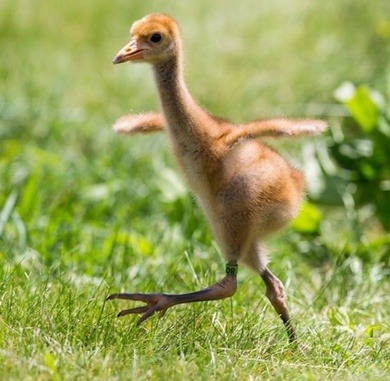
Okay so I have no clue how I'm gonna do this, I assume a format will arise as I go. But right now it's 3AM and I wanna talk about my favorite little birds: the Whooping Crane.
The Whooping Crane is one of the only two crane species native to North America, the other is the Sandhill Crane. (WE'LL GET INTO THOSE GUYS LATER I LOVE THEM TOO)
Anyway Whooping Cranes look like this:
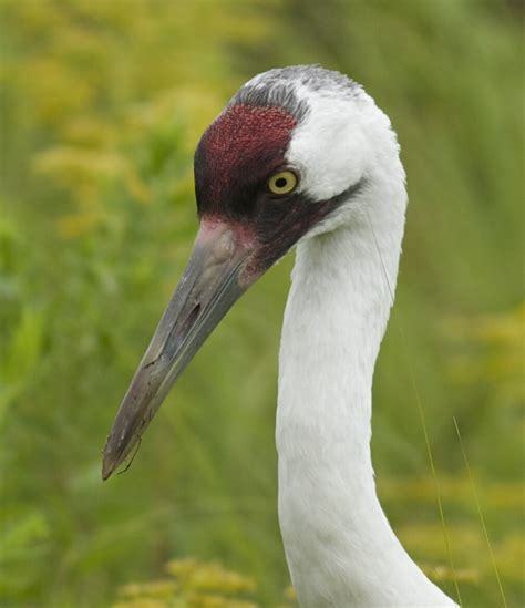
LOOK AT THAT AND TELL ME THEYRE NOT SO CUTE???

Appearance:
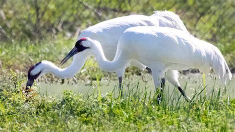
You can identify adult Whooping Cranes by their white feathers and patch of red on their head, which goes from their beaks to their cheeks! This patch of red is actually skin and isn't very feathery. They have long, pointed beaks, usually a gray color as you see above. They have yellow eyes and long, thin legs. I've also seen that these cranes often have the tips of their wings black.
Immature cranes have the same long beak and thin legs, but instead of white feathers, have a tan, cinnamon-brown coloring and no red spot. As they age, their white feathers come in, so the more brown feathers they have, the younger they are.
Did I mention that Whooping Cranes are really big? Because Whooping Cranes are BIG
The average height of these guys is approximately five feet (range of 4'1" to 5'3" from what I've seen) when they stand up straight, making them the biggest birds in North America. Their wingspan is 7.5 feet on average, though despite their massive height and wingspan, Whooping Cranes weigh roughly 15 pounds.
Habitat:
Whooping Cranes live in marshes, wetlands, fields, anywhere wet and grassy. They breed in the upper Midwest and around northwest Canada, and migrate south to the Gulf Coast, around Mexico.
I should also mention that Whooping Cranes are very endangered as a species. In the 1940s, due to overhunting and habitat loss, there was once only 21 Whooping Cranes alive—15 migrate birds in Canada/Texas, and 6 that lived year-round in Louisiana.
With human intervention, the species has now risen to a population of roughly 800 (I found an exact number of 836, but can't speak for its accuracy).
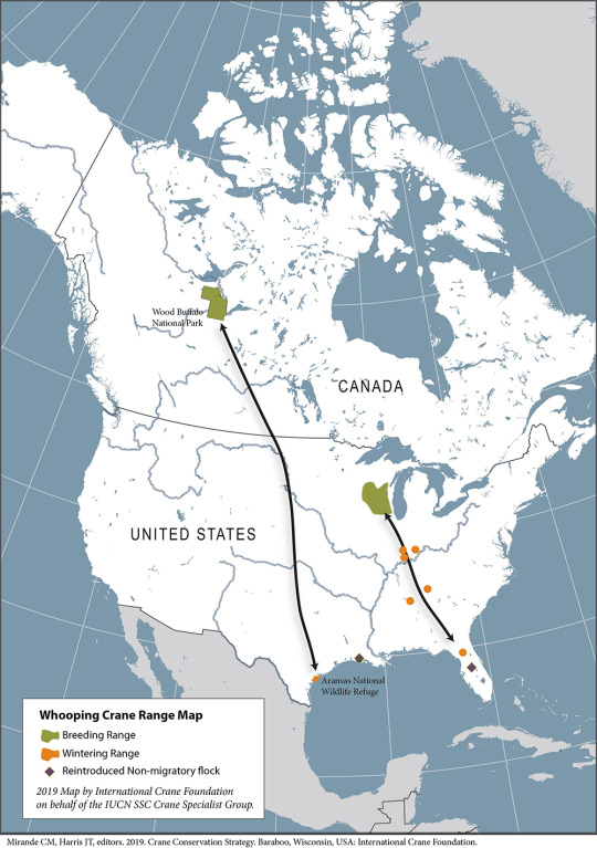
Here's a migration map I took of off savingcranes.org (please visit them, they're so cool)
Diet:
Whoopers (I saw someone call them that) ate omnivores, eating a mix of insects, amphibians, crustaceans, reptiles, and small fish and mammals. They'll also eat grain, marsh plants, plant tubers, and acorns.
Fun Facts:
Whooping Cranes' call sounds like a squeaky door. People will try to tell you it's this majestic, one-note mating call, but it is a door hinge that needs some WD-40. Here's a few videos on what they sound like :)
( https://youtu.be/NFzkXdZjQJM
https://youtu.be/8EobJR_jkjs )
Because of how Whooping Cranes almost went extinct, biologists had used aircrafts to teach young cranes how to migrate. (Here's an article on it: https://www.npr.org/2016/03/02/468045219/to-make-a-wild-comeback-cranes-need-more-than-flying-lessons)
They mate for life! They search for a mate at around 2-3 years, and then mate for life. They'll also continuously return to the same nesting and wintering territories. However, should their original mate die, they'll find another mate.
It's late, otherwise I would do more😭
Sources:
https://www.audubon.org/field-guide/bird/whooping-crane
https://savingcranes.org/learn/species-field-guide/whooping-crane/
https://www.nwf.org/Educational-Resources/Wildlife-Guide/Birds/Whooping-Crane
https://www.allaboutbirds.org/guide/Whooping_Crane/?_gl=1*10vkxuh*_ga*OTQ5Mjc2MzYyLjE2ODg1NDEwODY.*_ga_QR4NVXZ8BM*MTY4ODU0MTA5NS4xLjEuMTY4ODU0MTEyNC4zMS4wLjA.&_ga=2.29534207.1501623720.1688541086-949276362.1688541086
https://abcbirds.org/bird/whooping-crane/
I highly recommend checking these sites out, not just for Whooping Cranes, but for other birds.
3 notes
·
View notes
Text
Native Fish Hunting - Interlude!

Okay the last post didn't have a lot of interesting going-ons, I'm sorry to say. But this one will have some neat stuff I promise! Me and the wife drove over to southern Alabama to do some kayaking and found ourselves at a place called Crab Island. You best bet I made a beeline for it once I saw it on the map! Lots of cool native species to be found there.

The most populous invertebrate species on the island was of course... crabs! I mean, not really crabs, but they have "crab" in the name. We found dozens of Green/Striped Hermit Crabs (Clibanarius vittatus), one of our native brackish species that sometimes find their way into the aquarium trade. We found many between 1 and 3-4 inches long, I'd wager. This guy is covered in live snails, as were many of the other larger ones. I think they were immature Fighting Conchs (Strombus alatus).
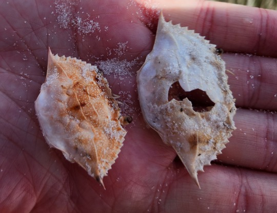
Anybody from the East Coast of the US is probably familiar with this species - the Blue Crab (Callinectes sapidus)! We found many of these shells washed up and spied a few live specimens, but I only made half-hearted attempts to catch them bare handed so you'll have to forgive me. I'm not really in the mood to be pinched!

We didn't see many live aquatic snails, mostly just the shells, but we did happen upon this American Crown Conch (Melongena corona), far from its maximum size of 5 inches. Still, a very cool find and I believe the first time I've happened upon a still-living specimen.
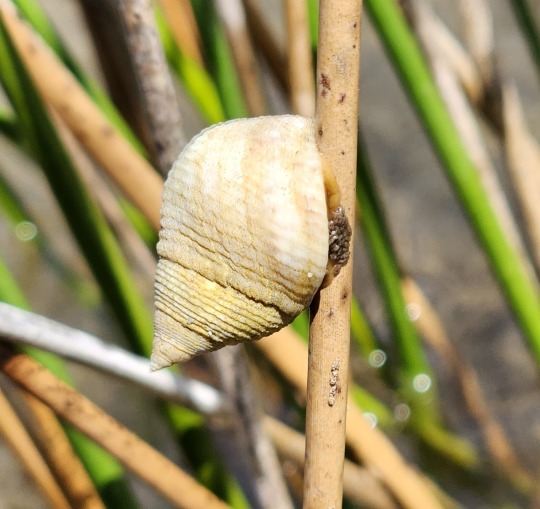
We weren't limited to aquatic snails either! We saw a dozen or two of these Marsh Periwinkles (Littoraria irrorata) which I found particularly interesting because we have the same species up north in Virginia. Not an active species by any stretch of the imagination but I've always found them neat.
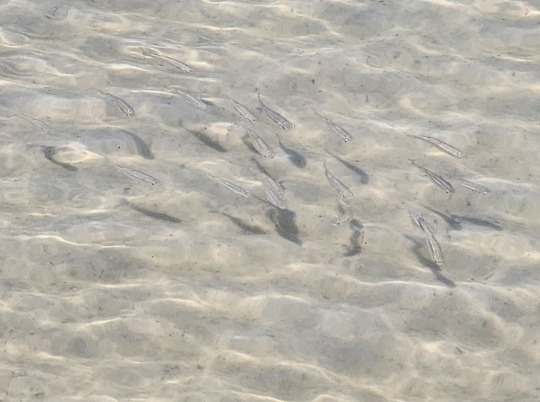
My wife correctly reminded me that I did not have an Alabama fishing license, so I left my nets in the car. Which is kind of a shame because there were hundreds of these killifish species (Fundulus spp) and I'd like to have known which they were! I'm pretty certain they are Gulf Killifish (F. grandis) but iNaturalist suggests that Longnose Killifish (F. similis) is more common here. I don't think it's the latter, but hard to say!

I didn't need a license for this guy though - this tiny Pinfish (Lagodon rhomboides) was deceased and must have just washed up moments before we arrived because it was in fantastic shape. Pinfish are probably one of the most common coastal fish in this area, but this was the first one I've found washed up like this.

I love these things. This is a skull of a Sea Catfish (family Ariidae), sometimes called Crucifix fish because of the shape of their skulls. This one was submerged in a pool of stagnant water, probably having been picked over by the fish here. iNaturalist suggests it is likely a Hardhead Sea Catfish, but given that Gafftopsail Catfish are also local, I'm not comfortable making such an ID.
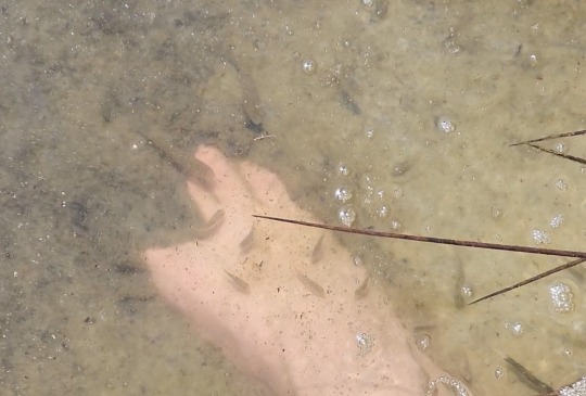
As I picked around in the pool of water, my feet were nibbled on by many of the smaller fish here! I could make out some of the same killifish as before, but also Sheepshead Minnows (Cyprinodon variegatus) as well - another species we can find in VA. Didn't get much in the way of good pictures due to glare, but fun experience nonetheless.
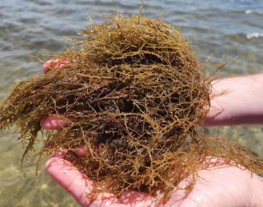
While I found some Sargassum seaweed washed up here too, the more interesting specimen was this fella! I think it's a Graciliaria species, but really it's hard to tell. Right now people are going NUTS online about sargassum washing up in Florida and any searches for "seaweed in florida" is coming up with hundreds of hits for those articles. So I'm gonna take my best guess!
3 notes
·
View notes
Text
Grackle beach party.
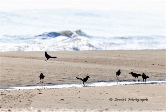
These are boat-tailed grackles at Holly Beach, Louisiana on the Gulf of Mexico. They look busy doing grackle stuff, though there is one in the background that looks like it's just enjoying the view.
"When you smell saltwater on the East Coast, it’s time to look out for Boat-tailed Grackles. The glossy blue-black males are hard to miss as they haul their ridiculously long tails around or display from marsh grasses or telephone wires. The rich, dark-brown females are half the size of males and look almost like a different species. Boat-tailed Grackles take advantage of human activity along our increasingly developed coast, scavenging trash and hanging out in busy urban areas away from predators." - allaboutbirds.org
#photo#photography#photographer#photographylovers#birds#birdwatching#birds of north america#birdsphotography#birdphotography#birdlovers#birds nature#birdingphotography#boat tailed grackle#bird#bird photography#bird watching#birding#blackbird
4 notes
·
View notes
Text
Pine Island and Alfred McKethan Pine Island Park
This is Part 2 of Bayport and Pine Island: Part of Hernando County’s Gift to the Nature Coast. Part 1 may be found by clicking on the link.
Pine Island Alfred A. McKethan Park is just a boat ride or short drive away from Bayport and features the only public Gulf beach in Hernando County.
Mr. McKethan was influential in the improvements made to what is now Cortez Boulevard, and the only road onto the island: Pine Island Drive.
In 1950, the sole residents on Pine Island were the Mr. and Mrs. Plummer, who ran a commercial fishing business. By the 1960s, their business was closed, possibly due to the purchase of all the land there by a Tampa company.
History of Pine Island
Housing development started mostly in the early 1960s, and as of the 2010 U.S. Census, the population was 64. That number had not changed from the previous census, so speculation is that it won’t increase much for the 2020 census. However, during a very recent visit to Pine Island, I did see several “For Sale” signs on open lots.
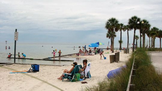
Pine Island Alfred McKethan Park is surrounded by water on three sides. The drive out Pine Island Drive is beautiful. The beach is white sand. Image courtesy of Hernando County.
The park sits on three acres, surrounded on three sides by water where sea grasses, fish and crabs enjoy the salt marsh and estuary. The white sand is so nice to feel between your toes, build a castle, run through, or just sit on. The tide changes, so it is good to check the times before wading out too far.
Pine Island Park Gets a Facelift after Hurricane Idalia Damage
Pine Island Park was temporarily closed for significant repairs due to Hurricane Idalia. The storm caused major damage to the infrastructure of Pine Island Park. Staff worked diligently with a local contractor to complete storm damage repairs.
Significant renovations to Alfred McKethan Pine Island Park were completed on March 28, 2024, including the playground area. Image courtesy of Hernando County Parks & Rec Department.
Hernando County Parks and Recreation officially reopened Alfred McKethan Pine Island Park on March 28, 2024. Normal operation hours are 8:30 am to sunset, 7 days a week. The parking fee is still $5 per car, payable by credit card only. Handicapped placards and Disabled Veterans are exempt from parking fees at all Hernando County parks. No RVs, buses, or trailers are permitted at the park.
Storms come in fast at Pine Island. Image by Diane Bedard.
An Introduction to the Gift of Pine Island
My first experience here was on a hot, sunny day in mid-July of 1988. It was my second day in Hernando County after driving down from Minnesota. A soon-to-be co-worker gave me a brief tour of Brooksville and then we headed out to the beach. The small beach was very crowded, but no one was actually in the water!
I waded in and immediately felt it was where I wanted to be. Suddenly a man’s voice called out “Ma’am, please come out of the water; there’s a storm coming in.” It was the lifeguard. I looked west, and sure enough, there were dark, ominous clouds moving towards us.
The warm water and beautiful view made me want to stay at Pine Island. Image by Diane Bedard.
There are no lifeguards now at the Park, so be mindful of the weather and tides! Where would I be if that lifeguard had not been there that day in 1988?
But enough about me.
Pay your 5 bits to park at Pine Island Alfred A. McKethan Park at the colorful entrance booth. It helps maintain the park and provide park services. Image by Deanna Kimbrough
Pine Island Beach Park Visitor Information
Pine Island Beach Park is currently open from 8:00 a.m. to sunset daily and has a $5 per vehicle parking fee, payable by credit card. The parking lot will accommodate about 100 cars, depending on the size and the precision of the driver (you know how parking lots can be).
Willy's Tropical Breeze Cafe is located in Pine Island Park
Willy’s Tropical Breeze Cafe is currently open, serving burgers, wraps, hotdogs, and fried seafood, along with a variety of beverages and ice cream.
Public restrooms are available and there are picnic tables and barbeque grills. A sandy volleyball court and a fully renovated, nautical-themed children’s playground are available. Make sure to do a dolphin watch from the observation deck.
Willy’s Tropical Breeze Cafe is open at Pine Island for grabbing a cold drink or fast meal. There are restrooms, picnic tables, barbecue grills, a playground, and a sand volleyball court as part of the fun amenities at Pine Island Alfred A. McKethan Park in Hernando County. Image by Deanna Kimbrough.
No Pets Allowed at Pine Island Park
People ask if dogs are allowed. Even though the park used to be pet-friendly every other Saturday morning, the Hernando County Parks and Recreation Department decided safety was an issue and ended that opportunity, so no pets are allowed.
The Park has been a special place to watch the sunset while enjoying a Drum Circle. But the group, known for playing hand drums and percussion instruments, had stopped during the social distancing time. Hopefully, they will return soon.
Sunsets at Pine Island are dramatic. It is a great place for dolphin spotting, also. Image by Diane Bedard.
Get out and Enjoy the Gift of Pine Island Park Today
The beach at Pine Island Park is an amazing place to have a picnic, relax, and watch a sunset, alone or with family and friends. It can also be a stunning venue for weddings.
The whole park has been renovated and continues to bring joy to young and old.
Enjoy the gift that is a beach this summer. Practice friendly sharing, wear sunscreen, be mindful of the tides, do not feed the animals, do not litter, and keep an eye on the weather!
Read the full article
0 notes
Text
Java-101, Go To Through Central Java Coffee Growing Areas
Having spent a decade living on the Gold Coast, I have a lot of favourite destinations. Anglers frequently catch bass nearly eight pounds, with some between 10 and 13 pounds. It grows on a tree and occurs singly on this really is.
2) Watch the Beach. Pack a picnic lunch and take along some folding chairs and get a destination listen to the roar from the ocean, inhale the salty air and watch the wildlife frolic of their natural atmosphere. One great beach in Lincoln City is Taft Park off of Hwy 101 and 51st SW. You'll find bathrooms because well as the famous Mo's restaurant. One more excellent feature beach, in Newport, Oregon is Nye Beach. Place get here by taking Olive E. west from Hwy 101 and parking at the end from the street by the Newport Performing Arts Studio room. There are also many unique shops here however browse by.
Tin Top Binh Dinh AZ View More: topbinhdinhaz.com - Top Binh Dinh AZ
Reviewed by Team Leader in Top Binh Dinh AZ: Lương Ngọc Nam Khang - Luong Ngoc Nam Khang
Everglades Water Conservation Areas are marshlands bordered by canals. Areas 2 has 210 square miles of marsh, and Area 3 contains 730 square miles of marsh., and Area 3 contains 30 square miles of marsh. Originally designed for flood control and water supply, designed provides some of the best bass fishing in the actual.
The best fishing usually occurs involving spring when dropping water levels concentrate fish the canals. April is numerous month with angler catch rates increased a 4.1 bass per hour in the L-67A Canal.

View More: topbinhdinhaz.com - Top Binh Dinh AZ
Reviewed by Team Leader in Top Binh Dinh AZ: Lương Ngọc Nam Khang - Luong Ngoc Nam Khang
Eastern Dragon. (Pogona barbata) This species also known as Jew Lizard and Frilly Lizard can be found along the eastern and southern coasts of Australia. It has bigger spikes, is more aggressive and displays its beard action more often. This is biggest bank species in the Pogona genus; some of these exceed 8 inches snout to vent time-span. They can be found in a number of habitats, including wet forests and dry scrublands. They eat array of foods such as insects, fruit, greens, flowers, and even smaller lizards.
Tin Top Binh Dinh AZ 24h South from the CBD could be the suburb of Paddington. Paddington is a Sydney insider's secret. The Oxford Street business strip is well suited for leisurely finding all inventions. You can locate a Sydney accommodation right there on Oxford Street or possibly quaint guesthouse just out of the main rob.
Mitchell's Bearded Dragon (Pogona mitchelli) lives in north-western Australia, in a variety of habitats, for Binh Dinh in Viet Nam the Great Sandy Desert. This is a minimal species, averaging only the.5in snout to vent length.
This picturesque village overlooks the River Mole and affords impressive views among the Betchworth Clump. Brockham lies about a mile away and features one of the attractive village greens in Surrey.
Sunset Bay is tucked within one of the most scenic areas relating to the Oregon Countryside. The campground has sites for tents and RV's also as cozy and comfortable yurts. Each campsite is mostly private and level with tall shrubs.
Let's go north now, across the "coat hanger" as the locals affectionately call the Sydney Harbor Bridge. Sydney's second CBD is close to the component in North Sydney. After that it's a little short distance to quite a few of Sydney's premier attractions such as the Taronga Park Zoo.
Five minutes drive contrary to the town of Slave Lake in north-central Alberta require you to Devonshire Gulf of mexico. The beach can be found within the Lesser Slave Lake Provincial Park. All 7 kms are of lake shore are lined with pristine sand and clear waters that popular for swimming, wind surfing and sand castle building.
If whale watching or seal spotting seems tame, why not try a closure look at the great white shark. Choose a between Dyer Island and Geyser Island is infamously referred to as Shark Alley. In case you are truly in order to ramp over the danger meter for your marine adventure, consider coming about supervised dives down in the deep, shark-infested waters capture a great white for the prowl. Do safari holidays get like i used to adventurous than this? Take a look at part, support if you're qualified diver. Some companies, however, allow you to go down within a shark cage without previous experience anyone must take a brief course to satisfy them and, probably, their insurance company! Imagine the exhilaration of seeing this predator with the deep.
youtube
Australia uses a diverse landscape with deserts as well as tropical areas. The climate of Australia is also quite diverse due which a large variety of flowers are accessible in america. Some of these flowers are extremely rare allowing it to be found only in this part on the planet. However, happen to be many other varieties of flowers in this continent, could be grown in other tropical and temperate regions as highly. Tin tổng hợp Top Bình Định AZ Moreover, apart from the nation's flower, each state of Australia has own floral emblem. Nationwide and state flowers of Australia are mentioned under.
As we feature on our journey product information head right down to New York in Large apple. This will about 2hours I recommended you spend a good few days here. Being known the City that Never Sleeps you could have so much to see and do, as well as an enormous variety of foods to taste. Visit the Statue of Liberty, or go best search engine optimization of the Empire State Building and examine the entire city. As well as many parks and Attractions while Central Park and shop until you drop at 5th Avenue.
This can be a modern town with plenty of peaceful open spots surrounding it. Binh Dinh in Viet Nam Gravelly Hill, situated southern. Fine views of the Weald and Pilgrim's Way are to be had from its summit.
On Oregon's north coast, the tiny town of Manzanita is endowed along with a mysterious, woodsy vibe just above its vast expanse of crystalline beach. Here, the San Dune Inn provides a vast array of freebies like bikes, game equipment, popcorn and video lessons. Stay at this charming, unassuming place just blocks from the beach and you'll find stuff for volleyball because games befitting the sand, as well as beach balls, bikes and simple sandcastle-making gear like containers. They have an enormous selection of movies, together with their choice of board games is a kick also. It's a kid's dream be realized.
3) Possess a campfire. Go with a bundle of wood and some matches, in your folding chairs and look at one through the day use picnic areas. Obtain couple of firepits at the South Beach Campground and Picnic area just South of Newport. In Lincoln City, take SE Devils Lake Road east from Hwy 101 (at the outlet mall) and drive to East Devil's lake state park. Of the parking area, there is really a trail increase the hill to a more secluded picnicking area with a firepit using a good look at the ocean. If you possess a canoe, kayak or other small boat, there is really a public dock you can set rid of.
We would not have a lot of critters in Utah. I sleep on forest floors and dive into lakes and rivers without a second thought. My Texas-bred wife nearly went into cardiac arrest the first time she saw me wade out in the Provo River for a swim. In Utah is actually an a notable lack of animals just take hurt/maim/kill you compared into the Deep South east. The most dangerous creature to hikers in Utah may be the rattlesnake- including he gives you fair warning before striking.
Along north of manchester Pacific coast, the involving Flamingo and Tamarindo offer the most popular fishing ranks. Here, sailfish could be caught the actual day entire year but very best fishing is from May to August. Tuna are abundant here during August to October. Individuals not uncommon to see tuna schools of 40 to 60 pounds as well as groups between 200 and 400 pounds. The bay of Papagayo from November to March can be a great starting point catch roosterfish. They will like shorelines and would be caught in around 60 feet of water. Good sized marlin, colorful dorado, and the wahoo also can be caught here at varying events of the 12 months.
The best part about staying at a quality bed and breakfast in Sydney, aside the affordability, is location tips and knowledge you'll answer from the people that invite you in. Most pros are doing their adventures like you, so it may be hugely beneficial to bounce ideas and thoughts off the other user.
And, anyone prefer to drive, increasing your spanking new highways that will take you there in approximately five hours from Costa Rica's capitol, San Jose. Should you drive, your adventure is likely to take you Jaco, a simple city in the central seacoast. Jaco is a famous party town in Costa Rica, a preferred among college kids, surfers, and partiers. And, are actually fishing outfitters, as well, if choose to to stay there.
Just to florida of town are miles and miles of sand dunes beneficial to hiking and also areas allow dune buggies as nicely. Great dining areas, miniature golf, gift shops and a good river boat round out the local sports.
View More: topbinhdinhaz.com - Top Binh Dinh AZ
Reviewed by Team Leader in Top Binh Dinh AZ: Lương Ngọc Nam Khang - Luong Ngoc Nam Khang
Written By Author in topbinhdinhaz.com: Nguyễn Mỹ Dung - Nguyen My Dung

Written By Author in topbinhdinhaz.com: Nguyễn Mỹ Trang - Nguyen My Trang
0 notes
Text
5 Best Places to Kayak in Naples and Bonita Springs, Florida
Naples and Bonita Springs, nestled along the sun-kissed shores of Southwest Florida, offer a paradise for paddling enthusiasts seeking to explore the serene waters and vibrant ecosystems of the region. With a myriad of picturesque waterways and scenic vistas to discover, these coastal havens beckon adventurers to embark on unforgettable kayaking excursions. Whether you're in search of tranquil mangrove tunnels, hidden coves teeming with wildlife, or expansive estuaries ripe for exploration, Naples and Bonita Springs have something to offer every paddler.
1. Estero Bay
Estero Bay, located just south of Fort Myers Beach, stands out as one of the premier kayaking destinations in Southwest Florida. Spanning over 10,000 acres of pristine waterways, mangrove forests, and saltwater marshes, this expansive estuary offers endless opportunities for exploration. Kayakers can navigate the meandering channels of Estero Bay, marveling at the diverse array of birdlife, dolphins, and other marine creatures that call this coastal paradise home.
2. Delnor-Wiggins Pass State Park
For those seeking a more secluded paddling experience, Delnor-Wiggins Pass State Park in Naples provides an idyllic setting for kayaking adventures. Paddle along the tranquil waters of Wiggins Pass, where the Gulf of Mexico meets the serene estuary, and soak in breathtaking views of pristine beaches, mangrove-lined shorelines, and vibrant marine life. With ample opportunities for birdwatching, fishing, and snorkeling, Delnor-Wiggins Pass State Park offers a quintessential Florida paddling experience.
3. Imperial River
Flowing through the heart of Bonita Springs, the Imperial River offers a scenic backdrop for kayaking adventures. Meander along its gentle waters, shaded by towering mangroves and lush vegetation, and immerse yourself in the tranquility of this hidden gem. Whether you're paddling solo or embarking on a guided tour, the Imperial River promises a peaceful escape into nature, with opportunities to spot manatees, otters, and an array of bird species along the way.
4. Naples Bay
Naples Bay, with its calm waters and stunning waterfront vistas, is a kayaker's paradise waiting to be explored. Glide along the bay's picturesque shoreline, past luxurious waterfront homes, mangrove islands, and bustling marinas, and soak in the beauty of this vibrant coastal community. With convenient launch points scattered throughout Naples, paddlers can easily access the bay and embark on their own self-guided adventure or join a guided kayak tour to learn more about the area's rich history and ecology.
5. Barefoot Beach Preserve
Nestled along the shores of Bonita Springs, Barefoot Beach Preserve offers a pristine setting for paddlers looking to escape the hustle and bustle of city life. Launch your kayak from the park's designated access points and paddle through winding mangrove tunnels, crystal-clear lagoons, and secluded coves. Keep an eye out for dolphins playing in the surf and manatees grazing on seagrass beds as you explore the tranquil waters of this coastal sanctuary.
In conclusion, Naples and Bonita Springs offer a treasure trove of paddling opportunities for kayakers of all skill levels. Whether you're seeking a peaceful paddle through mangrove-lined estuaries or an exhilarating adventure along the Gulf Coast, these coastal havens promise unforgettable experiences and breathtaking scenery at every turn. So grab your paddle, hop in your kayak, and embark on a journey of exploration and discovery in Naples and Bonita Springs, Florida.
1 note
·
View note
Text
Louisiana

Sportsman’s Paradise, is located in the southern region of the United States and is bordered by the Mississippi River to the east and the Gulf of Mexico to the south. The state boasts a unique blend of cultures, traditions, and histories that make it a captivating place to visit. From its rich history influenced by Native American tribes, French and Spanish colonial powers, and African slaves, to its renowned culinary and music scene, Louisiana has something to offer everyone.
Louisiana's landscape is characterized by flat plains, marshes, and swamps, and home to some of the Gulf Coast's most extensive forests. The state has the longest coastline of any state in the contiguous United States, with a length of more than 1,000 miles. The Mississippi River runs through the eastern edge of Louisiana, and many of its bayous and swamps are home to alligators, fish, and waterfowl.
Louisiana is known for its unique ecology, which includes vast marshlands, cypress swamps, and extensive wetlands. It is home to a diverse range of plant and animal species, including the American black bear, the American alligator, and the Louisiana pine snake.
Louisiana experiences a humid subtropical climate, with long, hot summers and mild winters. Hurricanes and tropical storms can hit the state during the summer and fall months, causing significant damage and flooding.
Despite facing several environmental issues, including coastal erosion, wetland loss, and sea-level rise, Louisiana's economy is diverse and includes industries such as oil and gas production, agriculture, and manufacturing. The state has a robust infrastructure that includes several airports, seaports, and railways, making it an essential hub for transportation and trade.
Visitors to Louisiana can enjoy a range of activities, from exploring historic sites in the French Quarter of New Orleans to fishing in the state's many waterways. Louisiana is home to several major cities, including New Orleans, Baton Rouge, and Shreveport. Must-see destinations in the state include the annual Mardi Gras celebration in New Orleans and the historic plantation homes along the Mississippi River.
Louisiana cuisine is world-renowned and includes dishes such as gumbo, jambalaya, and beignets, as well as a vast array of fresh seafood. Accommodations in Louisiana can suit every budget, from luxury hotels to cozy bed and breakfasts. Whether it's to experience the jazz and blues scene of New Orleans or to explore the state's unique natural beauty, Louisiana is a destination that should not be missed.
Sportsman’s Paradise
Sportsman’s Paradise is the nickname given to Louisiana due to the state's abundance of outdoor activities and natural landscapes for hunting, fishing, and exploring.
With vast marshlands, cypress swamps, and extensive wetlands, Louisiana offers premier hunting opportunities for waterfowl, alligators, and deer. For fishing enthusiasts, Louisiana boasts one of the largest commercial fishing industries in the country, with opportunities for both freshwater and saltwater fishing.
Along with hunting and fishing, Louisiana offers hiking, camping, and boating through its many state parks and wildlife reserves, allowing visitors to experience the state's natural beauty up close and personal.
Whether you are an avid outdoorsman or just enjoy spending time in nature, Louisiana's Sportsman’s Paradise has something for everyone.
boasts a unique blend of cultures, traditions, and histories that make it a captivating place to visit.
Louisiana is an extraordinary state with a diverse cultural and historical legacy. Visitors to Louisiana will find a unique blend of cultures, traditions, and histories that make it a captivating place to visit. From the vibrant music and art scene to the delicious cuisine and fascinating history, Louisiana has something for everyone. The state's French, Spanish, and African influences are evident in its architecture, language, and cuisine, making it a melting pot of cultures and traditions. The rich history of Native American tribes, French and Spanish colonial powers, and African slaves is evident throughout the state and can be explored through visiting museums, plantations, and historic sites.
A visit to Louisiana would not be complete without experiencing the famous Mardi Gras carnival held annually in New Orleans. The carnival is a celebration of Louisiana's unique cultural heritage and attracts visitors from all over the world. Visitors can enjoy lively parades, vibrant music, and delicious food during the carnival.
The state's natural beauty is also a major draw for visitors. Louisiana's flat plains, marshes, and swamps are home to unique species of wildlife, including alligators, waterfowl, and fish. Louisiana's extensive wetlands make up one of the largest ecosystems on the continent, making it a popular destination for eco-tourists and nature lovers.
When it comes to food, Louisiana is renowned for its incredible cuisine. The state's cuisine is a unique blend of French, Spanish, and African influences and includes dishes like gumbo, jambalaya, and crawfish étouffée. The state is also famous for its seafood, boasting delicious dishes like catfish, shrimp, and oysters.
Louisiana's unique blend of cultures, traditions, and histories make it a captivating place to visit. Whether you're interested in history, food, music, or nature, Louisiana has something for everyone.

Etymology
'Louisiana' is derived from the French term La Louisiane, which means 'Land of Louis.' The name was given by French explorer Rene-Robert Cavelier, Sieur de La Salle, in honor of King Louis XIV of France. Louisiana was first settled by the French, and their influence can be seen in the state's language, culture, and cuisine. Later, Louisiana was a Spanish territory, but the French culture continued to thrive. When Louisiana became a part of the United States, its French legacy remained, and today, Louisiana is known for its unique blend of cultures and traditions.
History
Louisiana has a rich and unique history that has been influenced by the interactions of different cultures and communities. The state was inhabited by several Native American tribes, including the Choctaw, Natchez, and Houmas, who were the first to shape Louisiana's culture.
However, Louisiana's modern history began in the late 17th century when French explorers, led by René-Robert Cavelier, Sieur de La Salle, claimed the territory and named it La Louisiane, in honor of King Louis XIV of France. The French established settlements and began trading with the Native Americans, particularly for furs and pelts, which became a major source of income for the French.
The Louisiana territory changed hands several times over the centuries. In 1762, France ceded the territory to Spain, and it remained under Spanish control until 1800, when it was transferred back to French ownership. However, just three years later, in 1803, France sold the territory of Louisiana to the United States in the Louisiana Purchase, which doubled the size of the young nation.
During the 19th century, Louisiana became synonymous with plantation culture and the brutal enslavement of African Americans. The state's economy was dependent on cotton, which was cultivated mainly by black slaves. African American slave labor was central to Louisiana's economic and social structure, but it was also a source of moral and political tension.
Louisiana played a significant role in the Civil War, where it fought alongside the Confederate States of America. The state saw several significant battles, including the Battle of New Orleans and the siege of Port Hudson. The defeat of the Confederacy led to the end of slavery in Louisiana, which was a watershed moment in the state's history.
Today, Louisiana's history is woven into its culture, traditions, and customs, from its rich Cajun and Creole heritage to its famous Mardi Gras celebrations. The state's unique blend of cultures and histories makes it a captivating and fascinating place to visit.
Colonization
The colonization of Louisiana began in the late 17th century when the French explorer Robert Cavelier, Sieur de La Salle, claimed the territory for France. La Salle named the region La Louisiane in honor of King Louis XIV of France. French colonizers established settlements in present-day New Orleans and Mobile, Alabama, and worked to establish trade relationships with Native American tribes in the region.
In 1762, France ceded Louisiana to Spain as part of the Treaty of Fontainebleau. Under Spanish control, Louisiana experienced significant economic growth through trade with the Spanish colonies in Central and South America, as well as the British colonies along the eastern seaboard of North America.
In 1800, the Treaty of San Ildefonso returned Louisiana to French control. However, facing financial difficulties, Napoleon Bonaparte decided to sell the territory to the United States in 1803 in what became known as the Louisiana Purchase.
The Louisiana Purchase doubled the size of the United States at the time, and President Thomas Jefferson saw it as an opportunity to expand American commerce westward. The acquisition of such a vast territory had significant implications for the United States, including the westward expansion of American settlers and the dispute over the extension of slavery into new territories.
Despite this, the acquisition of Louisiana proved to be a crucial moment in American history and paved the way for the growth of the American West. Today, Louisiana's rich history of French, Spanish, and Native American influences make it a unique and fascinating place to visit.
Civil War
During the Civil War, Louisiana played a critical role in the Confederate States of America. Its proximity to the Mississippi River made it a strategic location for controlling transportation and trade routes. The Union launched several campaigns to capture the state, including the failed Red River Campaign in 1864. Louisiana was also the site of several significant battles, including the Battle of Baton Rouge, Battle of New Orleans, and Battle of Mansfield. The Civil War left a lasting impact on Louisiana, with much of its infrastructure and economy destroyed. The state would spend many years rebuilding and recovering from the war's devastating effects.
Geology
Louisiana has a unique geological history due to its location on the Gulf Coast. Its landscape is characterized by flat plains, marshes, and swamps, thanks to the Mississippi River's deltaic sedimentation. The soil in Louisiana is rich and fertile, and the natural resources are abundant, including petroleum, natural gas, salt, and sulfur.The state contains some of the most extensive forests on the Gulf Coast, and the land is a haven for timber production. The swamp areas of Louisiana are critical habitats for numerous species of plants, animals, and birds. The Atchafalaya Basin, the largest wetland and swamp in the United States, is a significant natural resource that has supported the fishing and trapping industries for centuries. Moreover, Louisiana's swamps are home to some of the country's most exotic wildlife. The state is well-known for its alligators and features many tours that showcase these reptiles, even allowing tourists to hold young alligators.Louisiana's geology contributes significantly to its economy. The state's rich oil and natural gas reserves make it the second-largest oil producer in the country. the state's fertile soil and favorable climate mean that agriculture, including the cultivation of sugarcane and rice, is a significant industry.Louisiana's unique geology supports key industries, provides habitats for numerous species, and contributes greatly to the state's natural beauty.
Geography
Louisiana, a state located in the southern region of the United States, is situated between the Mississippi River to the east and the Gulf of Mexico to the south. It is bordered by Texas to the west, Arkansas to the north, and Mississippi to the east. Louisiana has a total land area of 52,378 square miles, making it the 31st largest state in the country.
The Mississippi River, which runs along the eastern edge of Louisiana, is one of the state's most important geographic features. The river is an essential transportation route for goods and people and is crucial to the state's economy. Louisiana is also home to many bayous, streams, and lakes that offer a variety of recreational opportunities, including fishing, boating, and wildlife viewing.
The Gulf of Mexico, which forms Louisiana's southern border, is another crucial geographic feature. The Gulf is a vast body of water that offers a range of recreational activities, including swimming, fishing, and boating. Louisiana's extensive coastline is home to many beaches, marshes, and islands that attract millions of visitors each year.
Louisiana's natural landscape is characterized by flat plains, marshes, and swamps, and is home to some of the most extensive forests along the Gulf Coast. The state's topography is heavily influenced by its proximity to the Gulf of Mexico and the Mississippi River.
Louisiana's unique geography and natural resources provide a perfect backdrop for exploring the state's rich history, culture, and natural beauty.
Coastline
Louisiana's coastline is a natural wonder, stretching more than 1,000 miles along the Gulf of Mexico. Spanning from Texas to Mississippi, it is the longest coastline of any state in the contiguous United States. The coastline is home to numerous beaches, bays, and inlets and is characterized by its white sand beaches and crystal-clear waters.
The Louisiana coast is not only a beautiful destination but also an essential part of the state's economy, providing access to shipping lanes, oil and gas reserves, and natural resources. The coast also serves as a crucial habitat for various marine life forms, such as fish, crustaceans, and sea turtles.
From sandy beaches to marshlands, the Louisiana coastline has it all. Visitors can witness the diverse ecosystems of the region, including sandy beaches, barrier islands, and wetlands. The marshlands are the ancestral home of the Chitimacha Tribe, one of Louisiana's recognized Native American tribes. These wetlands are also home to many species of birds, such as the roseate spoonbill and the great blue heron.
The barrier islands off Louisiana's coast are a must-visit attraction! These breathtaking islands are home to some of the state's most famous beaches, including Grand Isle, Cameron, and Rutherford. Visitors can relax on the sandy shores, fish from the piers, or try their hand at water sports like kayaking, paddleboarding, and windsurfing. These islands also serve as important nesting sites for migratory birds and sea turtles.
The Louisiana coastline has a rich history and is home to several landmarks, including Grand Isle State Park, Creole Nature Trail, and Sabine National Wildlife Refuge. These landmarks provide visitors with the opportunity to experience Louisiana's natural beauty and cultural heritage.
Louisiana's coastline is a unique blend of natural wonders, historical landmarks, and cultural heritage. No matter what your interests are, there is something for everyone along the Louisiana coast. Whether you want to relax on the beaches, explore the wetlands, or learn about Cajun culture, Louisiana's coastline has it all!
Rivers
When talking about Louisiana, one of the first things that comes to mind is its vast system of waterways, including the mighty Mississippi River. The Mississippi River runs for over 600 miles through the state and serves as a critical transportation route for manufacturing and shipping industries.
But the Mississippi isn't the only river in Louisiana. The state also boasts an extensive system of bayous and swamps that are home to various aquatic creatures, including alligators, fish, and waterfowl. The Atchafalaya River Basin, which spans over a million acres, is one of the most significant wetland areas in the country and serves as a refuge for numerous plant and animal species.
Fishing is a popular activity in Louisiana, and the state's rivers and waterways provide ample opportunities for freshwater and saltwater fishing. The Red River, which runs through the northern part of the state, is home to catfish, bass, and crappie, while the Gulf of Mexico off the coast of Louisiana is teeming with shrimp, crab, and oysters.
Many visitors to Louisiana also enjoy taking airboat tours of the state's bayous and swamps. These tours offer a unique opportunity to see alligators, turtles, and other wildlife up close while learning about Louisiana's unique ecosystem.
Louisiana's rivers, bayous, and swamps are an essential part of the state's culture and history. From shipping and transportation to fishing and tourism, these waterways play a vital role in the state's economy and provide countless opportunities for outdoor recreation and adventure.
Ecology
Louisiana's ecology is one of its defining characteristics, with an intricate system of marshlands, cypress swamps, and extensive wetlands. These wetlands are home to a vast array of plant and animal species, many of which are unique to Louisiana and the Gulf Coast region. The wetlands play a crucial role in maintaining the region's ecological health, providing habitat for game and non-game species.
The Mississippi River Delta and the vast expanse of wetlands provide a nursery and spawning ground for fish and shellfish of commercial and recreational importance, such as oysters, shrimps, and crabs. The wetlands also provide a vital filtration system for pollutants, and play a crucial role in buffering the coast from the effects of storms and hurricanes. However, Louisiana's wetlands are under threat from a variety of factors, including coastal erosion, oil and gas drilling, and development.
The cypress swamps of Louisiana are another unique feature of the state's ecology, and are home to giant cypress trees and an abundance of wildlife. These swamps play an important role in the region's water cycle, helping to regulate water flow and prevent flooding. These swamps also contain essential wildlife habitats and provide recreational opportunities for Louisiana residents and visitors alike.
In addition to the marshlands and cypress swamps, Louisiana has vast expanses of forests, which cover over half of the state's land area. These forests are home to a diverse range of wildlife, including black bears, deer, and wild turkeys. The forests also play a vital role in providing resources such as timber and pulpwood for the state's economy, and offer recreational opportunities for hunting, hiking, and camping.
Louisiana's ecology is a unique and valuable resource, and efforts must be made to protect and preserve it for future generations to enjoy.
Biodiversity
In terms of biodiversity, Louisiana boasts a rich and diverse range of flora and fauna, making it one of the most ecologically significant states in the country. The state is home to a wide range of plant and animal species, including many that are unique and endemic to the region.
The American black bear is one of the most iconic of Louisiana's animal species, with a population that thrives in the state's forests and woodlands.
Read the full article
0 notes
Text
ABC NEWS ANNOUNCES MARCUS MOORE AS FOREIGN CORRESPONDENT BASED IN LONDON
ABC News president Kim Godwin sent the following note to the news division announcing that Marcus Moore is beginning a new role as a foreign correspondent based in London.

Credit: ABC
Team –
I am excited to share that Marcus Moore will begin a new role next week as a foreign correspondent based in London.
For his new position, Marcus will move across the pond from Texas, where he’s been a vital part of our news division since 2017, serving as a Dallas-based correspondent.
Marcus is a talented reporter who brings sharp coverage to all of our programs and platforms, and he is no stranger to traveling the globe. He recently reported from Kyiv, Ukraine, and the Poland border on the ongoing war; from Guatemala and Mexico on families migrating and risking their lives in the process; and from the eye of Hurricane Dorian, as the category 5 storm devastated Marsh Harbour, Bahamas. He’s also reported on the assassination of former President of Haiti Jovenel Moïse and kidnapped missionaries from Haiti, on pro-democracy protests in Hong Kong, and on the deadly White Island volcano eruption in New Zealand.
Marcus is an Emmy Award winner who has also been on top of defining moments here at home, including the protests surrounding the death of George Floyd in Minneapolis and the deadly mass shootings in Uvalde, El Paso, Santa Fe and Sutherland Springs, Texas. Marcus is fluent in Spanish and Russian and before ABC, he was an anchor and reporter at WFAA, our Dallas affiliate. At WFAA, he reported on impactful stories including the November 2015 Paris attacks and filed reports on the Syrian refugee crisis from Istanbul, Turkey. While working as a reporter for ABC affiliate KMBC in Kansas City, he covered the 2010 rescue of 33 trapped miners in Chile and as a reporter for WAPT in Jackson, he broadcasted live as Hurricane Katrina battered the gulf coast. Marcus landed his first TV gig at just 16 years old at KBTX in Bryan, Texas, as a studio camera operator, working his way up to weekend reporter by age 18.
We are so lucky that Marcus is part of our ABC News family. Please join me in congratulating him on his new, well-deserved position!
#oneabcnews
Kim
0 notes
Text
Journal 2- Field Trip 1
Valentina Mercante
Professor Ndiang’ui
IDS 3920
11 September 2022
Journal 2
On September 8th, we visited Florida Gulf Coast University’s Campus Sustainability tour, nature walk trail , and cypress dome for our first field trip. Our first stop was at FGCU’s Veterans Pavilion. The pavilion is a covered area at the center of campus that honors former, present, and future veterans. It also serves as a safe space for students and faculty to sit for rain coverage. The pavilion also is used for those that utilize their first amendment right of free speech to speak their minds.

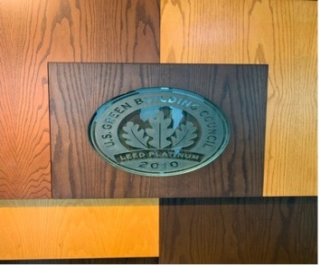
Next, we stopped at the green building- Seidler Hall. It is Leed Certified, which benefits include better health, improved workforce, and saved money. Materials are recycled, lights are motion sensor activated, and toilets are in low flush mode. All these qualities make it a highly sustainable building that promotes green goals.
We then made our way to Pavilion in front of the pond. The building is also green and promotes sustainable efforts. The trash can in front of it compacts trash. It helps reduce waste and prevents animals from entering, these can be located almost anywhere on campus. The ponds are interconnected and also lead into the Estero River. The sidewalks in front of it are designed to aid with runoff.

One of my favorite stops was learning about the Cylinders. Many of the classrooms on campus are powered by these large Cylinders that are filled with big blocks of ice. This works by trapping the ice in these cylinders, and letting it melt which created a cooling system. This is why in the winter the classrooms do not get as cool, because the ice is not melting due to cool temperatures. Using these cylinders as opposed. To standard air conditioning units helps reduce energy use.

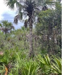
Finally, we entered the Nature trail. At first stop we spoke about the ecosystem there and how the main tree population consisted of palm trees and pine trees. Sable palms stick out in the front and there are also saw palmettos. The Gopher Tortoise is a keystone species for the ecosystem, meaning that without them it would collapse. This was interesting to me because at first, I did not even know what a gopher tortoise was but knowing that a species so underrated is so important in keeping the ecosystem together was very thought-provoking. It was also the location where the most wildfires occur.

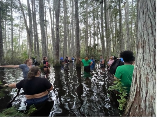
Our next stop was by the Oak Hammock and Pine Flats. It was a cooler area that is shaded. There we learned about Firms and Epiphytes which are air plants that do not require soil. After that was the freshwater marsh, marshes do not have trees. There we saw cypress trees, which are tall, thin, and needle like. In the water was an alligator flag, when it moves, it is an indicator that wildlife is in the area.
As we started walking towards the Cyprus dome, the water became deeper, and more roots and palms appeared on the ground.
At the end, we arrived at the cypress dome where the water was waist deep and surrounded by tall cypress trees. I noticed how peaceful It felt there being one with the nature around us. As I have only just recently moved to Fort Myers from Miami, I learned a lot on this field trip. I always knew how much nature and wildlife surrounded our campus area but never fully understood it until now. I also knew that FGCU was a sustainable campus but never really knew how until our field trip. I now know what makes it sustainable, from the green buildings to the cylinders, to the trash compactors and ponds. My sense of place has evolved from having virtually none, to now feeling like a part of myself resonates with the nature trail. I now have a memory/experience with that part of our ecosystem and that is what I believe to be my sense of place.

0 notes
Note
Here's my EPA propaganda:
The EPA is giving you the ozone layer back, keeps your drinking water clean and free of contamination, and probably extended your lifespan by protecting you from everything from lead and asbestos to certain pesticides and even skin and lung cancer by repairing the ozone layer and improving air quality. The EPA does something for everyone.
From its creation in 1970 to 1990, America's generation of air pollution decreased by between 1/3 and 1/2, in large part because of its enforcement power over corporations. The EPA's work isn't just significant in terms of climate change, it is saving and improving the quality of human lives right now.
It funds and conducts its own research and has the power to create and enforce regulations on companies to protect environmental and human health. Basically, it finds problems, creates solutions, and threatens and sues corporations into compliance.
The EPA also manages a superfund of billions of dollars to step up and clean up hazardous waste sites when no one else will, such as when there are multiple responsible parties or when parties are uncooperative.
I'm not sure how familiar people are with the Deepwater Horizon Oil Spill, but it's considered the largest and most famous oil spill in history. In 2010, British Petroleum (the inventors of the "carbon footprint?") allowed a plant of theirs to explode, resulting in a 57,500 a square mile oil slick over the Gulf of Mexico, devastating the wildlife (including fragile marsh and estuary ecosystems) and endangering the livelihoods of nearby residents, who depended upon the beaches to bring tourists and money to their communities.
You know those dish soap commercials where they wash black sludge baby duck? Imagine 134 million gallons of that sludge.
The EPA and Coast Guard worked together to coordinate the 4-year cleanup effort, funded by BP itself-- the EPA also has the authority to assure the cooperation of the responsible party in the cleanup process, taking a total of about 60 billion dollars from BP.
Complete restoration is not possible in cases like this. But the Gulf of Mexico would look very different today if we did not have a federal government agency with the resources and authority to carry out the cleanup as it did.
Right now, the EPA is ensuring that Norfolk Southern pays for the cleanup of the train derailment in East Palestine, Ohio, and testing the air and drinking water for contaminants. It is far from perfect, but it is a good thing we have it. The EPA protects environments and it protects us.
Sources: Almost entirely Encyclopedia Brittanica (Specifically the articles Environmental Protection Agency, Clean Air Act, Clean Water Act, and Deepwater Horizon Oil Spill), EPA's own site to confirm the specific roles of the CERCLA and OPA because I was briefly confused, and NPR's interview transcript How EPA Plans To Keep East Palestine Residents Safe After Derailment for that last bit.
TL,DR? The EPA saves lives, saves ecosystems, and enforces environmental and health regulations on large corporations.
As a history buff, I appreciate this kind of propaganda
140 notes
·
View notes
Note
Hi!! Loving the sambucky fluff dairy series ❤. Could you do the #4 please? Thank you.
Hey, anon! Thank you so much for the wonderful prompt choice! I was hoping someone would choose this one 😆 Enjoy! 🥰
Date 23 of 28: Watching the Sunrise
| - 22 - | - Prompt - | - 24 - |
On a wooden path, down through the coastal marsh, Bucky watches Sam from behind as they jog. It was like walking past little islands, passing by the submerged grass beds, the floating shrubbery, the coastal mangrove thickets. all of it surrounded by the brown water of the Gulf Coast, the darkness of morning before the sun creating almost an ethereal effect to the world around them, as if they were suspended in another time, another world.
He and Sam had joked about it a few times; both avid readers of science fiction and fantasy, their lives becoming a sci-fi show, really. Why not joke about how the morning jog felt as if being transported to another world?
"You're going too fast," Bucky whined, "It's too early - go slower."
Sam laughed.
"You can outrun cars, Bucky. You're fine," said Sam, keeping up his pace because the world was cruel and didn't want Bucky to watch Sam jog for a longer period of time than he was getting, "Besides, we won't make it if I don't keep this pace."
Which was true.
Bucky didn't always go on Sam's jogs, especially when they were this early in the morning, but Sam had wanted Bucky to see the sunrise with him and how could Bucky say no to that? A sunrise lighting Sam with warmth, getting to see Sam's gap-toothed smile as the day began?
Only a fool would pass that up.
"Maybe next time we watch the sunrise on YouTube or something," Bucky mused, thinking about what it would be like to let Sam sleep in, keep him cuddled up in bed with coffee and some breakfast, watch it on the flatscreen they had in their room, Bucky curled up next to Sam as they did.
Yeah.
Bucky was going to suggest that next time.
"You are just - the worst about mornings," said Sam, shaking his head, "How did I fall for a guy who couldn't get up at the crack of dawn with me?"
"Because I'm incorrigible. And charming. And I know how to do those several things that you really like," said Bucky, grinning.
"You know how to do everything I like, you very meticulous weirdo," bemoaned Sam, "Is your robot brain keeping everything stored in your Sam file?"
"I think you meant 'Meticulous Lover'," said Bucky, snorting as they got to the end of the wooden path, the both of them stopping, "And it's because I want to do everything in a way you like."
"Annoyingly lovable. That's what you are," said Sam, sitting down on the dock, the sun starting to peek out, "Are you going to sit with me or what?"
Bucky did as he was told, sitting down next to Sam, putting his arm around Sam, leaning his head on Sam's shoulder, just watching Sam watch the sunrise.
"Okay. So maybe this was worth it," said Bucky, awestruck by the scene, lovestruck by Sam.
Sam gazed down at Bucky, giving Bucky that gap-toothed smile.
"It definitely was," said Sam, soft.
❤️ ❤️ ❤️
Want to choose a date for Sam and Bucky to go on during this special February Daily SamBucky Fluff Diary event? Check out the prompts here and send me an ask! I’ll write you a drabble as one of my Daily SamBucky Fluff Diaries!
#thank you for the prompt anonymore! 🥰#sambucky#sambucky drabble#sam wilson#bucky barnes#the daily sambucky fluff diary#28 short sambucky dates#date 23#watching the sunrise#the two sit there for a while#watching each other bathed in the light of the rising sun#my headcanons#my drabbles
26 notes
·
View notes
Text
Pine Island and Alfred McKethan Pine Island Park

This is Part 2 of Bayport and Pine Island: Part of Hernando County’s Gift to the Nature Coast. Part 1 may be found by clicking on the link.
Pine Island Alfred A. McKethan Park is just a boat ride or short drive away from Bayport and features the only public Gulf beach in Hernando County.
Mr. McKethan was influential in the improvements made to what is now Cortez Boulevard, and the only road onto the island: Pine Island Drive.
In 1950, the sole residents on Pine Island were the Mr. and Mrs. Plummer, who ran a commercial fishing business. By the 1960s, their business was closed, possibly due to the purchase of all the land there by a Tampa company.
History of Pine Island
Housing development started mostly in the early 1960s, and as of the 2010 U.S. Census, the population was 64. That number had not changed from the previous census, so speculation is that it won’t increase much for the 2020 census. However, during a very recent visit to Pine Island, I did see several “For Sale” signs on open lots.
Pine Island Alfred McKethan Park is surrounded by water on three sides. The drive out Pine Island Drive is beautiful. The beach is white sand. Image courtesy of Hernando County.
The park sits on three acres, surrounded on three sides by water where sea grasses, fish and crabs enjoy the salt marsh and estuary. The white sand is so nice to feel between your toes, build a castle, run through, or just sit on. The tide changes, so it is good to check the times before wading out too far.
Pine Island Park Gets a Facelift after Hurricane Idalia Damage
Pine Island Park was temporarily closed for significant repairs due to Hurricane Idalia. The storm caused major damage to the infrastructure of Pine Island Park. Staff worked diligently with a local contractor to complete storm damage repairs.
Significant renovations to Alfred McKethan Pine Island Park were completed on March 28, 2024, including the playground area. Image courtesy of Hernando County Parks & Rec Department.
Hernando County Parks and Recreation officially reopened Alfred McKethan Pine Island Park on March 28, 2024. Normal operation hours are 8:30 am to sunset, 7 days a week. The parking fee is still $5 per car, payable by credit card only. Handicapped placards and Disabled Veterans are exempt from parking fees at all Hernando County parks. No RVs, buses, or trailers are permitted at the park.
Storms come in fast at Pine Island. Image by Diane Bedard.
An Introduction to the Gift of Pine Island
My first experience here was on a hot, sunny day in mid-July of 1988. It was my second day in Hernando County after driving down from Minnesota. A soon-to-be co-worker gave me a brief tour of Brooksville and then we headed out to the beach. The small beach was very crowded, but no one was actually in the water!
I waded in and immediately felt it was where I wanted to be. Suddenly a man’s voice called out “Ma’am, please come out of the water; there’s a storm coming in.” It was the lifeguard. I looked west, and sure enough, there were dark, ominous clouds moving towards us.
The warm water and beautiful view made me want to stay at Pine Island. Image by Diane Bedard.
There are no lifeguards now at the Park, so be mindful of the weather and tides! Where would I be if that lifeguard had not been there that day in 1988?
But enough about me.
Pay your 5 bits to park at Pine Island Alfred A. McKethan Park at the colorful entrance booth. It helps maintain the park and provide park services. Image by Deanna Kimbrough
Pine Island Beach Park Visitor Information
Pine Island Beach Park is currently open from 8:00 a.m. to sunset daily and has a $5 per vehicle parking fee, payable by credit card. The parking lot will accommodate about 100 cars, depending on the size and the precision of the driver (you know how parking lots can be).
Willy's Tropical Breeze Cafe is located in Pine Island Park
Willy’s Tropical Breeze Cafe is currently open, serving burgers, wraps, hotdogs, and fried seafood, along with a variety of beverages and ice cream.
Public restrooms are available and there are picnic tables and barbeque grills. A sandy volleyball court and a fully renovated, nautical-themed children’s playground are available. Make sure to do a dolphin watch from the observation deck.
Willy’s Tropical Breeze Cafe is open at Pine Island for grabbing a cold drink or fast meal. There are restrooms, picnic tables, barbecue grills, a playground, and a sand volleyball court as part of the fun amenities at Pine Island Alfred A. McKethan Park in Hernando County. Image by Deanna Kimbrough.
No Pets Allowed at Pine Island Park
People ask if dogs are allowed. Even though the park used to be pet-friendly every other Saturday morning, the Hernando County Parks and Recreation Department decided safety was an issue and ended that opportunity, so no pets are allowed.
The Park has been a special place to watch the sunset while enjoying a Drum Circle. But the group, known for playing hand drums and percussion instruments, had stopped during the social distancing time. Hopefully, they will return soon.
Sunsets at Pine Island are dramatic. It is a great place for dolphin spotting, also. Image by Diane Bedard.
Get out and Enjoy the Gift of Pine Island Park Today
The beach at Pine Island Park is an amazing place to have a picnic, relax, and watch a sunset, alone or with family and friends. It can also be a stunning venue for weddings.
The whole park has been renovated and continues to bring joy to young and old.
Enjoy the gift that is a beach this summer. Practice friendly sharing, wear sunscreen, be mindful of the tides, do not feed the animals, do not litter, and keep an eye on the weather!
Read the full article
0 notes
Last Seen Blogs

deye4me
first things first

digitalita
🥜 ꒰ resources galore ! ꒱


-k---h-
-k-h-
flyingmishmeshincognito
That Flying Mish Mesh