#San Joaquin River Photos
Text
A Little Peek into Current Projects
Since travel in the Sierra Nevada Mountains right now is unwise, I’ve looked far closer to home to find material for my not-very-scientific look at how climate change affects the Central Valley. Luckily for me, being a creature of habit, I happened to have two years of photos from the same exact location on the San Joaquin River at pretty much the same time of year—there’s only a ten day…

View On WordPress
#artist#California#Central Valley News#climate change#Climate change in Fresno#flooding photos#Fresno#Fresno California#local photographer#photographer#photography#River flooding#River photos#San Joaquin River#San Joaquin River Flooding#San Joaquin River Photos
1 note
·
View note
Photo
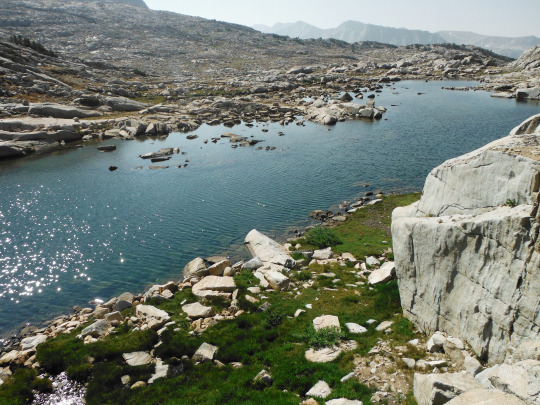
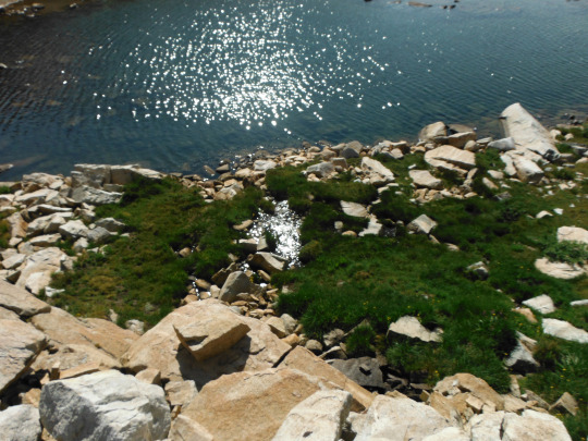
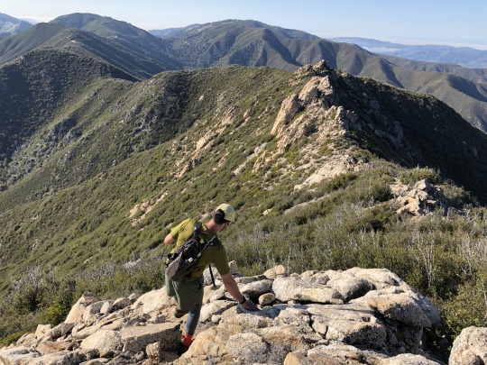
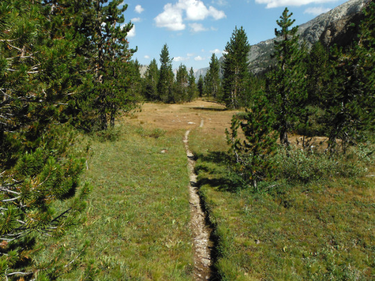
Following these small lakes, the source of Pinnacles Creek which feeds into Piute Creek, which feeds into the San Joaquin River, which flows to the San Francisco Bay. John Muir Wilderness, Sierra Nevada Mountains, California, USA. Photo by Van Miller
#pinnacles lakes basin#san joaquin river#Piute Creek#san franciso bay#san francisco#hiking#backpacking#camping#john muir wilderness#Sierra Nevada Mountains#california#©Van Miller#photography#travel#Wanderlust#geology#lakes#mountains#Wilderness#the wilderness journals
218 notes
·
View notes
Text
Photos: Postcards from the Sierra, where they are still skiing and the water is flowing
Aug. 1, 2023 - LA Times
It was a drought-busting winter.
Mammoth Mountain and the Sierra Nevada range recorded a record amount of snow, as area reservoirs returned to full capacity.
Times photographer Luis Sinco took a drive down the Eastern Sierra's to see first hand the snowmelt that is finally giving way to summer.
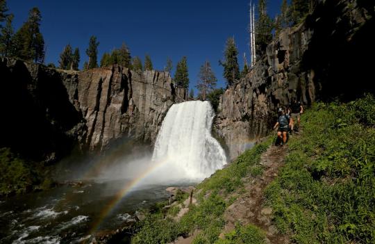
Hikers follow a trail along Rainbow Falls in the Devils Postpile National Monument. The falls are fed by the middle fork of the San Joaquin River, which is running strong after last winter's record snowfall in the Sierra Nevada. (Luis Sinco / Los Angeles Times)
#orgone#orgonite#orgone energy#weather#climate#sierras#sierra nevada mountains#mammoth mountain#snow#record snowfall#california
3 notes
·
View notes
Text
Map of San Francisco Bay 1850 vintage California Nautical Chart Wall Map Restoration style map coastal decor map Large Map by VintageImageryX
19.44 USD
Map of San Francisco Bay 1850 vintage California Nautical Chart Wall Map Restoration style map coastal decor map Large Map
This Is a Highly Detailed California nautical chart of the San Francisco bay area
extending up river to the cities of Sacramento, San Joaquin
Created by Cadwalader Ringgold in 1850
This Map Has Great Detail See Photos
THIS WILL PRINTED ON SMOOTH FINE ART WATERCOLOR PAPER
This Fine Art Print has been reproduced from the original source .
using UltraChrome K3 Inks which are rated up to 125+ years
not cheap inks that will fade in 3 months
This map will include a border of white for framing and Matting purposes which can be trimmed off if needed (not included in the size)
very suitable for framing
Interior shots are for representation only your map may or may not be similar in size
PERFECT FOR YOUR HOME OR OFFICE
Thank you for looking.
Truly a rare find
0 notes
Text
Caitlin fink pictures

Caitlin fink pictures full#
The Children’s Museum of Stockton offers hands-on exhibits – wikipedia. In nearby Lodi, Micke Grove Regional Park includes a Japanese garden, the San Joaquin County Historical Museum and Micke Grove Zoo. STOCKTON (CBS13) Caitlin Fink, a high school student in Stockton who works in the porn industry, spoke to CBS13 on Friday after an article about her touched off a free-speech debate that. Oak Grove Regional Park has trails, a nature center and a lake stocked with catfish. The Haggin Museum features fine art and local history displays. Geo quick facts: Stockton is a city on the San Joaquin River, in California’s Central Valley. “It actually takes a toll on your body and people don’t last long. Lives in: Natick, MA Prior addresses: Natick, MA, Boston, MA, Brookline, MA.
Caitlin fink pictures full#
See our full results of Caitlin Fink below. These records include 33 phone numbers and 57 addresses for the name Caitlin Fink. “People think that in p**n it’s all fun and games, but it’s not,” Fink said. We uncovered 22 results for the name Caitlin Fink. She then suggested that she’s not the only young person who may be thinking about entering the industry. “It’s just profiling how she managed to overcome these kinds of obstacles and to get to where she is now, where she has a successful career and is living on her own money - she is self-reliant.”įink, who is estranged from family, said in a phone interview on Thursday that she felt it was important to share her story to help educate others on the reality of working in the adult industry. “In her freshman year she said her grades were really bad and she was associating with the wrong group of people,” Kirkbey told The Record last week. Carolin Fink attends the Bernhard Wicki Award 2018 during the Munich Film Festival 2018 at Cuvilles Theatre on Jin Munich, Germany. Before & After Photos Video Gallery Merge/Sell Career Opportunities. The story was profiled on the Gary and Shannon show on KFI, Los Angeles.Īccording to RecordNet, the article, written by junior Bailey Kirkbey, is a profile of Fink and focuses on the challenges she faces, how she has managed to overcome them and how she has created a successful career for herself in the adult industry. 274 Carolin Fink Premium High Res Photos Browse 274 carolin fink stock photos and images available, or start a new search to explore more stock photos and images. See Caitlin Nicole Finks age, phone number, house address, email address, social media accounts, public records, and check for criminal records on Spokeo. Caitlin Fink, DO is a board-certified physician practicing medical & surgical dermatology.
0 notes
Text
LOTD: Southampton Shoal (1)
(from: http://www.ibiblio.org/lighthouse/ca.htm)
Southampton Shoal (1)
1905. Inactive since 1960. Square wood tower with lantern on a 2-story Victorian keeper's house. The original 5th order Fresnel lens is on display at the Angel Island Interpretive Center. The lighthouse originally had 3 stories and was located on Southampton Shoals, northeast of Angel Island and southwest of Point Richmond in San Francisco Bay. In 1966 the upper two stories were relocated to Tinsley Island in the San Joaquin River delta about 15 miles (25 km) northwest of Stockton, where the building is used as a yacht club. Beth McIntyre's photo is below, the Coast Guard has a 1953 historic photo of the light on station, Marinas.com has aerial photos of the present location and Google has a satellite view. Accessible only by boat, and permission to land should be obtained in advance. Site and tower open by appointment. Owner/site manager: St. Francis Yacht Club. ARLHS USA-777.

(full photo found here; ©Beth McIntyre)
0 notes
Photo

Black-tailed jackrabbits (Lepus californicus) are generally solitary, avoiding others of their kind except during breeding season.
These two rabbits; however, were observed by the critter cam in a nighttime encounter at the San Joaquin River National Wildlife Refuge in California. Jackrabbits may be drawn together by a common food source such as green, growing grasses and forbs that may be a little more scarce during this arid time of year.
Photo by San Luis National Wildlife Refuge
28 notes
·
View notes
Text
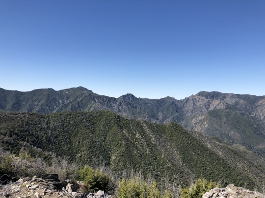
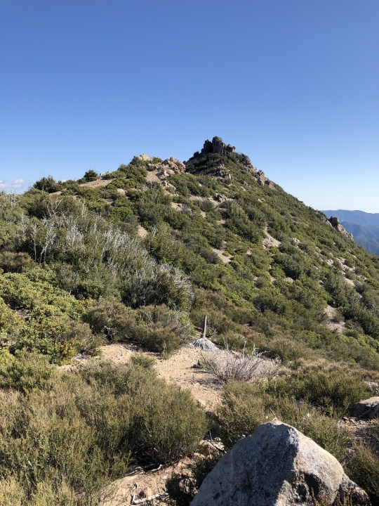
Miller Mountain & Black Butte from Tassajara Road, Ventana Wilderness

It was my third consecutive weekend heading to China Camp Trailhead in the Ventana Wilderness. I had climbed South Ventana Cone, Chews Ridge and Ventana Cone over the previous two weeks, so it made sense to "finish off" the area and climb Miller Mountain as well. This was all part of my plan to climb the Ventana 15, and the relatively short drive to the trailhead was also part of the allure. Asaka was 8 months pregnant, so I didn't want to go too far away from home in case the time finally came. Surprisingly both Daryn and Colin were willing to join me again, chalking it up to quarantine restlessness. I knew the truth was really that they both greatly enjoy my company. There were no surprises as we followed the Pine Ridge Trail 3.5 miles to the Church Creek Divide. By this time we were experts on this section of trail.

Behind Pine Valley were Ventana Double Cone, Uncle Sam Mountain and Miller Mountain.

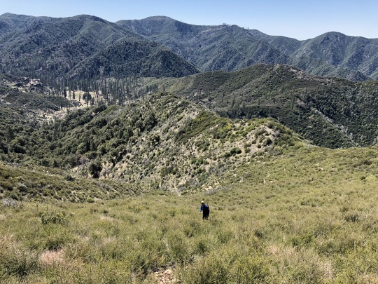
Once at the saddle, we took a right down into Pine Valley. This was new experience for all of us. The saddle was dry, but spring water started to emerge as we descended down the canyon. After a little more than 5 miles we reached the historic cabin built by Jack English. It was a beautiful area.

We picked up the Carmel River Trail here, but it was hard to follow initially as it crossed through a marshy meadow.
We left the trail at a creek flowing down the southeastern slopes of Miller Mountain and followed this up the rarely traveled canyon.

I planned to follow the canyon further, but found it easier to climb up the ridge to the south of the peak. Once atop the ridge, we had great views of the summit (minus the bug in the photo).

Back to the west were Ventana Cone and Double Ventana Cone.
There was some easy bushwhacking along the ridge. The vegetation had burned in a fire, but it was steadily growing back. It looked worse than it ended up being.
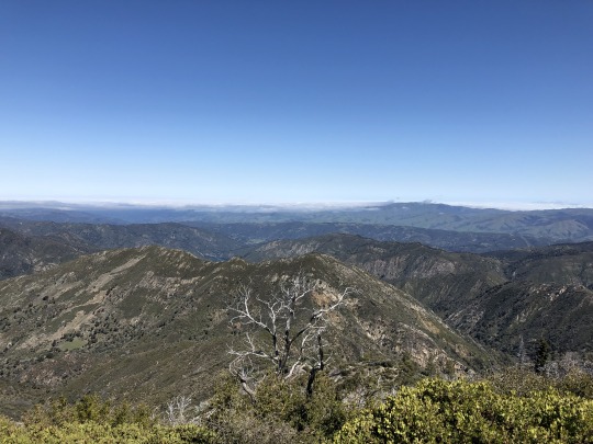
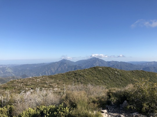
I was happy to reach the summit, considering I was not sure that we would make it at all. To the northeast was the Salinas Range.
To the northwest were Uncle Sam Mountain and Elephant Mountain.
To the west were Ventana Cone and Double Ventana Cone.

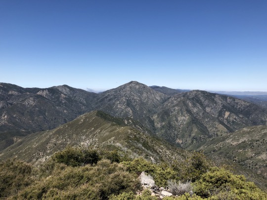
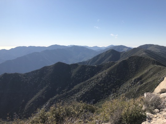
To the southwest were Junipero Serra Peak and South Ventana Cone.

To the southeast was Chews Ridge. We considered following the ridgeline back to China Camp but it looked brushy and difficult.

-Bug!

It was still early so we decided to eat lunch later. We followed a similar route down, this time staying more on top of the ridge. As we dropped into one of the gullies, we found a deer carcass laying in the creek. Earlier on I was about to fill up in the creek downstream and I'm very thankful that I didn't.
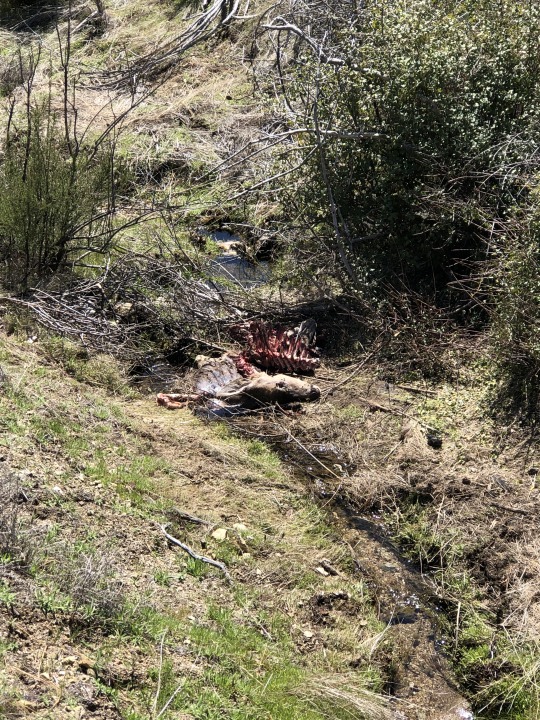
We wondered what killed the deer. My money was on a mountain lion. We followed the creek out until we intersected the trail once again.

We stopped for lunch at the cabin. There were some nice benches to sit on here.
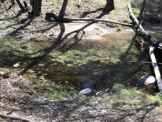
Colin walked over to the Carmel River and saw a fish. We had considered bringing our fishing gear, but I was skeptical that they would live so close to the headwaters.


-Carmel River
The remaining journey to the car was a dull march uphill. I had a lot of time to think about bonus peaks. We had enough daylight to climb Black Butte which stood just down the road from the car, but the question was if we would have enough energy. I started my pitch as we hiked the last couple miles. Both Daryn and Colin were still uncommitted by the time we reached the car, so I suggested we just drive down the road to check it out. Once at the trailhead, I pointed at the peak, pretending to be surprised with regards to how close we were to the summit. This tactic worked on Colin surprisingly; Daryn was too experienced to fall for the oldest trick in the book. With Colin now in, Daryn also agreed to come. Off we went down the dirt road.

The dirt road ended and the bushwhacking began. This was the part that was not visible from earlier. Luckily, there was a clipped trail through the brush.
There was a lot of ducking and pushing away branches, but we got through the worst of it to some open terrain.
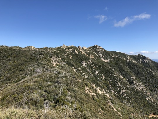
It was now just a matter of running the ridge. We scrambled around a false summit. The true summit stood just a short distance further.

We all made the summit, happy that we went through with it in the first place.

To the southeast were Pinyon Peak and Junipero Serra Peak.
Pinyon Peak on the left is still my hardest hike to date.
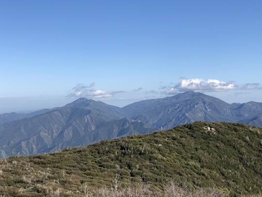
To the south were Cone Peak and Twin Peak.

To the southwest were Black Cone and White Cone.

To the northwest were South Ventana Cone, Ventana Double Cone and Uncle Sam Mountain.
To the northeast was Palo Escrito. The Sierra Nevada was even visible across the San Joaquin Valley.
I was very happy with our extra credit. I felt very accomplished and I think the others were too.
We retraced our steps back along the ridge and drove back home that afternoon.
2 notes
·
View notes
Text
The Eulogy

Summary: The Serpents say a final goodbye to their fallen brother.
Word Count: 1,389.
Author’s Note: This is part of the @southsidearchive daily prompt series, whereby a single word prompt is given each day and members write a short piece based off of that prompt. Today’s prompt was WIND.
MASTERLIST
When they found him in the armchair three weeks ago, cold and blue lipped with ‘sacrifice’ branded into his forehead, something about it was different.
The Serpents had lost members before, old and young, and although it had been something that had affected them, the death of Joaquin DeSantos hit deeper and stung that bit more.
Maybe it was his legacy that made it so painful, or maybe it was how they’d found him, discarded once the Gargoyles had used him for all they could and he became worthless to them, but whatever the combination of reasons was, the Serpent dynamic changed that day.
Joaquin has been second in command to King FP Jones, taking on the prestigious role of Serpent Prince when FP’s own son hadn’t yet shown an interest in becoming a fully fledged member of their extended family. Joaquin was pipped as the favourite to take over the crown and he had been slowly but surely prepped by FP for months to succeed him upon his relinquishment of the throne. Joaquin wasn’t just a face in the pack of leather-clad members, he embodied exactly what the Serpents were and what they strived to be.
The day he was sent to San Junipero for his own safety and the safety of the gang was difficult. Sent off alone with only a one way ticket and duffle bag, the Serpent Prince had felt the throne slip from his grasp, and with an unstable monarchy, the Serpents struggled with the loss of someone they’d grown to love and respect so deeply.
Sweet Pea, Fangs and Toni had grown up with him, taking their places under his wing as he helped them navigate life as teenage snakes. Being a few years older than them, they looked up to him as not only a friend or a brother, but as an inspiration and a person to strive to be like. When he packed up and left without a goodbye, they didn’t have anyone to keep them grounded anymore, or anyone to stop them from making the same mistakes that he did when he was their age.
The trip to San Junipero wasn’t just a one way ticket with a duffle bag; truthfully, it was a life sentence. As soon as he stepped foot onto that bus, his life was on a collision course with an untimely fate, that neither he, nor anyone else, could have anticipated.
The decline started with Joaquin having to leave his boyfriend Kevin behind in Riverdale, followed closely by him having to spend months alone trapped in his own mind without those who’d sworn to stand alongside him. When he was called back to Riverdale to help Fangs Fogarty escape from the hell that was descending upon him, he thought that that might have been a way back into a normal life again, but being arrested and taken to the Leopold and Loeb Juvenile Detention Center scuppered those plans and tilted the axis of his world.
After escaping from the Detention Center and the hellish pits of the underground fight club within it, he quickly fell in with the wrong crowd, spending his last days as a member of the Gargoyle Gang, immersed in the world of Gryphons and Gargoyles. His days were numbered from that point onwards. A short time after his infatuation with G&G really took ahold of him, we find ourselves returning to the beginning- his end, when they found him in the armchair three weeks ago, cold and blue lipped with ‘sacrifice’ branded into his forehead.
Serpents from across the State travelled to attend his funeral, faces old and new coming together to celebrate his life and mourn his death. Atop his coffin sat his Serpent jacket, the leather draped over the dark oak of his casket. He wore it in life, and he deserved to wear it in death.
A motorcycle procession followed the hearse as it made its journey through Riverdale and to the crematorium, ready for the town to say their final goodbye to the teenager who everyone seemed to have a soft spot for.
There were wreaths and pictures of him in the hearse next to his coffin; pictures from when he was just old enough to walk, to pictures of him receiving his first Serpent jacket, his last picture with Kevin and a candid photo Toni had taken of him on her camera at the Wyrm where he looked the happiest she’d ever seen him.
And now, a week after Joaquin’s ceremony, the Serpents stood at the Fox Forest look out point, ready to spread his ashes, joined by Kevin, the preppy boy he’d grown to love.
“This is where Joaquin and I came on our first official date,” Kevin told the group, his voice shaking as he knitted his hands together. “He told he it was his favourite place in the whole of Riverdale because he could sit up here on his bike when the sun was setting and just appreciate the town.”
The Serpents were quiet, watching Kevin, their gazes softening at every word as their eyes became glassy and their hands sunk deeper into their pockets.
“He liked the way the street lights seemed the twinkle once the sun had gone down, and the way that Pop’s looked like a beacon of neon-lit hope in a town as jaded as ours. He liked listening to how Sweetwater River crashed around, and hearing the Forest come alive around him. He said that he could see the stars from up here. He gave Fox Forest a new meaning to me, and if there was one place that embodied Joaquin, it’s here.” Kevin paused, taking a moment to look out over Riverdale as his throat grew tight. “Joaquin, if you’re listening, I hope we’ll meet again some day. I’ll love you forever, and I’ll never, ever forget you. Never.”
FP squeezed Kevin’s shoulder gently as the teen choked up and his face flushed red with emotion. FP gave him a shallow but reassuring smile and a fatherly nod, trying to convey everything that he couldn’t say.
“You know, I never thought I’d lose Joaquin, I always thought he’d be the one who buried me,” FP started, turning his attention to the urn in his hands. “This kid was like a second son to me, and I should have done more to protect him- I let him down, sent him away when I should have fixed the mess I got him into. It’s too late for me to fix that, even though I wish I could, but I know that this is my last chance to do something right by him by giving him the send off he deserves.”
FP stood up a little straighter, looking out across the group of Serpents before raising one hand and making the signature snake symbol with it.
“To Joaquin, a loyal Serpent and friend to all. There will never be another person like him, and we are all lucky to have encountered him in the many ways we did. His impact on our lives will live forever, and we’ll never forget him. He may be gone in body, but in us his spirit lives on- we love you brother.”
“To Joaquin!” The Serpents and Kevin called out in unison as FP unscrewed the lid to the urn, scattering the ashes over the edge of the lookout point and into the wind as it picked up and brought the forest alive around them, just like how Joaquin liked it.
His ashes followed the path of the wind and blew down towards Sweetwater River and the Southside, with some lingering and landing at the lookout point where he once sat on his bike admiring the view that he was now apart of. Now he’d be here in life and in death.
The Serpents were silent, watching with shaky hands, clouded minds and glossed eyes as they said the final goodbye to their brother. The wind was warm and kind, the sunset beautifully fierce in the sky and it felt like Joaquin was saying goodbye to them just as much as they were to him.
Joaquin DeSantos, a boy who’d found himself lost and alone at one point in his life, was free, whisked away by the wind and back into Riverdale where he belonged.
#just a little something for todays daily prompt!#joaquin desantos#joavin#southside serpents#serpentcentral#Kevin Keller#fp jones#riverdale#joaquin DeSantos drabble#joaquin desantos imagine#drabble#SAP
104 notes
·
View notes
Text
Natural Disaster Prevention vs Response
To what extent can natural disasters be prevented?
This question is likely to become a critical area of discussion as we plan to respond to the many changes, such as increases in extreme weather events, presented by climate change.
The Director-General for Global Issues at the United Nations, Hans-Joachim Daerr, makes a critical point on this subject in this statement when he argues that, “The consequences of extreme natural events are not, however, disasters to be simply accepted as inevitable. They are the product of natural hazards and the vulnerability of existing social and ecological systems to these hazards. It is often detrimental anthropogenic influences that lead a natural event to become a natural disaster: extreme urbanization in endangered areas, establishment of hazardous industries in risk-prone locations, artificial straightening of river courses and destruction of natural flood plains, deforestation and soil erosion, and a lack of awareness and dearth of knowledge of existing risks” (Federal Foreign Office, 2004).
In order to address these vulnerabilities, it is critical that communities as well as critical decision makers prioritize disaster prevention rather than solely disaster response. This concept can be further explored by examining a case study of the San Joaquin Delta.
The San Joaquin Delta is a roughly 700 mile long winding waterway which is fed by runoff from the Sierra Nevada Mountains and Southern Cascade Mountain ranges. Approximately one-third of the Delta’s water feeds into the San Francisco Bay Area. This crucial watershed runs through California’s capital city of Sacramento and has approximately 1100 miles of levees which protect the surrounding areas from flooding. These levees are subject to breakdown or failure due to events such as erosion, storms, and seismic activity, like earthquakes. The vulnerability of these levees has been well documented and yet remains under addressed.
If these levees were to break, not only would surrounding communities be flooded, but much of the surrounding farmland near the Delta, which is lower in elevation than the Bay Area, would be flooded by salt water threatening critical food supply for a large population.
This is a major vulnerability for California in terms of being a potential natural disaster. Plans for preventing this catastrophe must be prioritized over response plans. Efforts for prevention can include: the use of setback levees to widen waterways in order to increase surface area for flooding, supporting local communities in raising their homes, schools, and essential service buildings such as grocery stores and hospitals, and ensuring that sufficient floodplains are available if massive flooding were to occur. By increasing the resiliency of the communities that surround the Delta water system, we will ensure that adequate effort has been made to reduce the threats posed by a devastating flood. It is through the prioritization of planning for events such as strong storms and flooding, that we can potentially move their categorization from a natural disaster to a natural event.
by: Chelsea Thomas
Written for ESPM 194
Quoted resource:”Are Disasters Inevitable? The disaster reduction strategy of the Federal Foreign Office” 2004
Photo Credit: CA Department of Water Resources (water.ca.gov)
1 note
·
View note
Text
#nature photography#photographer#photography#nature photos#san joaquin river#nature#beautiful photos#water#fresno
0 notes
Photo
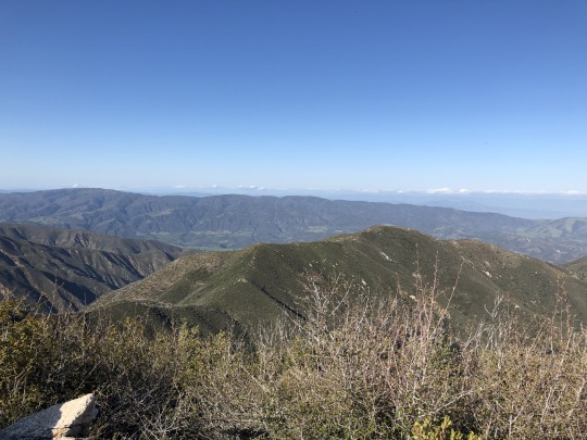
The Goddard Canyon Trail descending into the South Fork of the San Joaquin River drainage. Sequoia-Kings Canyon National Parks, SEKI, Sierra Nevada Mountains, California, USA. Photo by Van Miller
#goddard canyon#south fork of the san joaquin river#san joaquin river#Wild Rivers#rivers#sequoia-kings canyon national park#seki#Sierra Nevada Mountains#california#©Van Miller#hiking#backpacking#camping#outdoors#Wanderlust#travel#Wilderness#the wilderness journals#photography
43 notes
·
View notes
Text
Iconic scenery in 24 hours- San Ramon to Kings Canyon National Park and return
At the Volti 40th anniversary concert on 5/4/2019, we chatted with Ted Morgan who sang in the original San Francisco Chamber Singers back in the Stone Age. Ted invited us to a hike & picnic in Kings Canyon National Park, a fund-raising event sponsored by the San Joaquin River Parkway and Conservation Trust. Knowing what an incredible place Kings Canyon is, we quickly agreed!
Left San Ramon at 7:30pm on Friday to avoid the commute traffic over the Altamont Pass. Arrived at the Piccadilly Hotel at the FAT airport (Fresno) around 10:30p, then woke up at 6:30 for a 7:30 am start. Needed to be at Zumwalt Meadow by 10am for the event, which we made with 10 minutes to spare. Awe-inspiring scenery all the way, particularly once we descended into the Canyon and followed the pounding river with cascades and white water around every bend.
Our 1-mile hike was very gentle, led by a friend of the organization (Frank Helling) who channeled John Muir, complete with Scottish brogue and a fascinating talk about local plants, animals & history. Followed up with a nice lunch & wine, and then headed back. Stopped at 2 waterfalls (Roaring River & Grizzly), and made about a dozen additional photo stops on our way out of the Park. The final stop was at the General Grant sequoia grove, an amazing place. The sequoia trees are truly magnificent.
Had dinner at a pizza place in Modesto on our way home. Arrived back around 10pm, tired but happy with another adventure!
3 notes
·
View notes
Text
Map of San Francisco Bay 1850 vintage California Nautical Chart Wall Map Restoration style map coastal decor map Large Map by VintageImageryX
19.44 USD
Map of San Francisco Bay 1850 vintage California Nautical Chart Wall Map Restoration style map coastal decor map Large Map
This Is a Highly Detailed California nautical chart of the San Francisco bay area
extending up river to the cities of Sacramento, San Joaquin
Created by Cadwalader Ringgold in 1850
This Map Has Great Detail See Photos
THIS WILL PRINTED ON SMOOTH FINE ART WATERCOLOR PAPER
This Fine Art Print has been reproduced from the original source .
using UltraChrome K3 Inks which are rated up to 125+ years
not cheap inks that will fade in 3 months
This map will include a border of white for framing and Matting purposes which can be trimmed off if needed (not included in the size)
very suitable for framing
Interior shots are for representation only your map may or may not be similar in size
PERFECT FOR YOUR HOME OR OFFICE
Thank you for looking.
Truly a rare find
0 notes
Text
Fresno CA Daily
Understanding the city life in Fresno helps you prepare for it especially if you have plans of relocating in the area. Generally, this is a car-oriented region but streets are also conducive for walking and biking. The overall weather is typical of the San Joaquin Valley. Expect hot summer and mild winters. Neighborhood is a mixture of races with White Americans and Latinos dominating the area. The lower cost of living and diverse job opportunities are attractive reasons for more migrants to come and live in the city. However, it is important to take note that around 30% of the population still lives below the poverty.
youtube
Delk Pest Control
Although cost is a major deciding factor when it comes to choosing the right pest control company, it should not be the sole reason to close a deal. You should also take a look at their track record and after-sales customer service. You may check the reviews or ask your friends and neighbors. Delk Pest Control has been in the business since 1934 servicing even our forefathers. That is almost a century of expertise! No other company can surpass the dedication and experience of Delk Pest Control. From a simple bug business in the 1930’s, it is now one of the most renowned companies offering comprehensive pest control in the whole California.
Owner of Fresno’s Haron Jaguar witnessed Notre Dame Cathedral burn. See his photos and video
Randy Haron is a professional photographer, though you might now him better as the owner of downtown Fresno’s Haron Jaguar Land Rover dealership. He just happened to be in Paris when the iconic Notre Dame Cathedral was burning. And he had his camera with him. Haron shared some compelling photos of the fire on his Facebook page and Instagram, where he has more than 99,000 followers under the name @2ndfloorguy. He agreed to let The Fresno Bee share some of his images. Read more here
Opportunities come to those who are ready. In the case of Randy Haron, a professional photographer, he was able to capture the devastating fire that ate up Notre Dame Cathedral in Paris. His lens captured the sad event while it was happening. Netizens all over the world have verbalized their grief over this event. Comments flooded his original post on Facebook. The 12th century cathedral has historical significance and the beautiful architecture is very impressive. Amidst all the commentaries, authorities in Paris vowed that they will do their best to restore and rebuild what was damaged by the fire. Recall that the incident happened alongside the Holy Week Celebration of the Catholics.
Island Waterpark in Fresno CA
Beat the summer heat by going to one of the most popular destinations in Fresno, the Island Waterpark. The park is a great place for family fun. It offers a wide variety of water activities and adventure. They have giant slides, rain-forest themed water playground, sand beach, lazy river, wave pool, and a lot more. There are also shaded picnic tables and souvenir gift shop. Since they offer season passes and allow families to bring in food, you can cut down your overall vacation expenses. They also offer exclusive parties for special occasions like birthdays. The refreshing pools and other attractions will surely drive away the summer heat.
Link to map
Driving Direction
8 min (3.0 miles)
via W Shaw Ave
Fastest route, lighter traffic than usual
Foster's Donuts
2714 W Shaw Ave, Fresno, CA 93711, USA
Head south toward W Shaw Ave
121 ft
Turn right onto W Shaw Ave
Pass by El Pollo Loco (on the right in 0.4 mi)
1.7 mi
Continue straight to stay on W Shaw Ave
0.2 mi
Turn right onto N Golden State Blvd
0.8 mi
Turn left onto W Barstow Ave
0.1 mi
Turn left onto W San Madele Ave
Destination will be on the left
0.2 mi
Delk Pest Control
5645 W San Madele #106
Fresno CA 93722
1 note
·
View note
Text
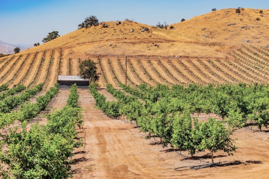
California's Central Valley grows about 40 percent of the U.S.'s fruit, nuts, and produce, but has also used up too much groundwater. Now the state is searching for creative ways to refill its aquifers. Photograph By Patricia E. Thomas, Alamy Stock Photo
The Deceptively Simple Plan To Replenish California’s Groundwater
The state pumps too much groundwater, especially during droughts. Now, it's learning to refill the overdrawn bucket. "It's the simplest math in the world," says one scientist.
— By Alejandra Borunda | March 23, 2022
PARLIER, CALIFORNIA — From afar, the rows of knobby grapevines blend into the landscape of pink-blossomed almond trees and fragrant citrus. But get up close and you’ll see something strange: The trunks of the vines are standing in several inches of glistening, precious water.
These grapes, at the Kearney Agricultural Research Center in California’s San Joaquin Valley, are part of a grand experiment that many hope will help solve the state’s deepening water crisis. Here, in the state that provides some 40 percent of all the fresh produce grown in the United States, a 20-year-long drought has left growers and communities desperately short of water. To make up the persistent shortfall from rain and snow, they are pumping groundwater—and doing so far faster than water can trickle down from the surface to replenish underground aquifers.
The drought has only amplified an old problem: Californians have been overusing groundwater for a century, in part because it was unregulated. That changed in 2014 with the passage of a landmark state law requiring local water agencies to control the overdraft by 2040. They’re now scrounging for solutions.

One popular idea, which scientists are testing on the flooded grapes at Kearney, is to “recharge” overdrawn aquifers with water that would otherwise flow to the sea unused—the torrential precipitation that often comes during winter, for example, when farmers don’t need it. Farmers and water managers alike are trying to capture some of those precious pulses by intentionally flooding farm fields, wetlands, and other key places. Letting that water recharge California’s in-the-red aquifers would be a cheaper, more ecologically sensitive, and effective way to prepare for drought, proponents argue, than building more dams and reservoirs.
“It’s obvious we’ve been living well beyond our means,” says Aaron Fukuda, the manager of the Tulare Irrigation District in the San Joaquin Valley, one of the most seriously overdrawn regions of the state. “We all know we’ve either got to shrink the demand or increase the supply… and groundwater recharge is becoming the go-to solution.”
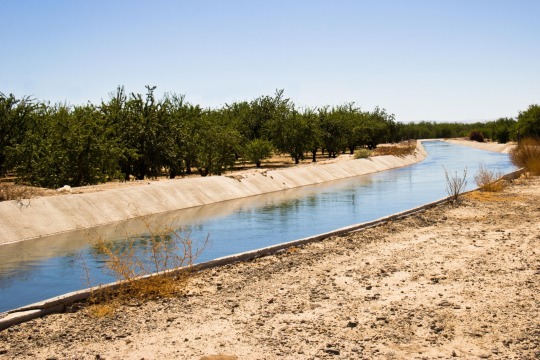
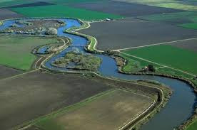
A vast network of canals and ditches bring irrigation water to farms across the San Joaquin Valley. They could also be used to carry water for refilling aquifers. Photograph By Ava Peterson, Alamy Stock Photo
Water Onto Wine
Don Cameron has been thinking for decades about how to get water back underground.
Cameron has managed Terranova Ranch, a 5,500-acre farm in the San Joaquin Valley, since 1981, and he has long relied on groundwater. In the early days, that was easy: He and his team would hook up some 100-horsepower engines to wells and pump away. But over time, some wells dried up. Others had to be punched deeper. The ranch had to start running 200-horsepower engines just to keep the water flowing.
It was obvious to Cameron the problem would only worsen. He worried it would put him or his neighbors out of business; water is one of farming’s non-negotiable ingredients.
A solution also seemed obvious. If the issue was too much water coming out of the ground, wouldn’t it be simplest to try to put some back whenever an opportunity arose?
That opportunity appeared in February of 2011. After a dry year, an unexpected storm dumped snow and rain, sending a long glug of extra water down the King’s River, which snakes along the edge of Terranova Ranch. Cameron diverted some of it into a series of deep canals and ditches built in anticipation of this exact moment, set up a series of small pumps, and pumped enough water onto a field of wine grapes to flood them nearly two feet deep.
His neighbors were aghast, thinking there was no way the plants would survive a drowning. But Cameron’s intuition told him otherwise—the wild ancestors of grapes evolved along rivers, after all. “I was pretty damn sure they could handle having their feet wet,” he laughs.
The water kept disappearing into the ground, so he just kept pumping—all the way through June, well after buds burst and leaves unfurled, for a total of 13 feet of water over the season: enough to cover a football field to well above the field-goal crossbar.
The grapes survived just fine. The bigger value of the experiment, though, was to pique others' interest. Cameron talked about his experiment constantly, hosting taco-truck talks at the farm and evangelizing the idea to scientists, policymakers, and farmers alike.
The following year, California sank into an epically bad phase of its long-running drought, one that would deepen and linger until 2016. So little rain and snow fell that farmers in some parts of the San Joaquin Valley had their surface water deliveries cut to as little as 40 percent of normal. Groundwater use, which makes up about 40 percent of all water use even in a wet year, shot even higher.
Like Cameron, other farmers found their wells running dry. Entire communities started to hear their pumps sputter. In some places the ground has sank more than 20 feet because its underbelly was drained of water.
That was the context in which lawmakers managed to push through the Sustainable Groundwater Management Act, or SGMA (pronounced “sigma”) in 2014. California became the last state in the West to put limits on groundwater use.
“It took over 100 years for our groundwater oversight to catch up with our surface water, but we got there,” says Kaymar Guivetchi, an engineer at the California Department of Water Resources.
Refill The Bucket
There are really only two ways to stop emptying a groundwater bucket, explains Alvar Escriva-Bou of the Public Policy Institute of California (PPIC): draw less water, or fill the bucket back up.
“It’s the simplest math in the world,” says Rosemary Knight, a geologist at Stanford University.
Using less water would probably require fallowing farmland, causing losses for growers and their communities. Compared to that, refilling the bucket is much more palatable—and so Don Cameron’s ideas about recharging groundwater got very, very popular.
“It was like someone flipped the switch,” says Cameron. “They saw that this was going to be a thing that was sustainable and could keep them in farming. It sank in all of a sudden.”
The idea is straightforward: When extra water rushes through the state’s waterways, some of that could be “peeled off” and diverted to fields, recharge basins, wells, or other floodable sites.
In some ways, this would mimic California’s historical, pre-settlement water cycle, says Guivetchi. Before the era of dams and long-distance canals, California valleys flooded much more frequently, when mountain snowpack melted in huge spring gushes or big storms dumped heavy rains. The floodwaters would seep down into aquifers below. But enormous 20th-century state and federal water projects replumbed the region, draining natural flood zones, channelizing rivers, and fundamentally disrupting the natural water cycle to support agriculture and hydropower.
“The water cycle wants to operate the way it’s done for millennia. But our institutions have sliced and diced it to the point where it’s become dysfunctional,” Guivetchi says.
Restoring more of the natural flood cycle to refill aquifers is something that many groups in the state agree on. The challenge, says Guivetchi, is how to get it done, not on a few hundred acres, as at Terranova Ranch, but likely on many thousands.
Putting Water Back On The Land
The groundwater in the San Joaquin Valley is overdrawn by about 2 million acre-feet a year— about one-third as much as all Californians use in their homes. (An acre-foot would cover one acre, a football field, in one foot of water.)
No one yet knows exactly how much of that deepening debt can even be repaid. Local water districts’ SGMA plans currently propose to fill about 40 percent of the hole with recharge. But an independent analysis from the PPIC found that recharge could fill only about 25 percent of the overdraft.

Ideally, water would be injected in confined zones where deposits of coarse gravel or sand offer a direct channel to an aquifer. Such “sweet” zones are rare, but Fukuda’s Tulare Irrigation District already uses one, and the state is spending $12 million to find more.
Stanford researchers led by geophysicist Knight have figured out how to find them from the air or by driving overland on a 4x4. Equipped with an instrument that maps subsurface geological structures by measuring their electrical conductivity, the team can tell gravel and sand—through which water travels easily—from clay, which stops its downward motion.
Hyper-effective recharge zones probably won’t be enough, though. Farmers will also need to be willing and ready to flood their fields.
“This is why we’re here at the research station,” says hydrogeologist Helen Dahlke, as she pulls her boot out of squelching mud in the flooded grapevines at Kearney. “Torturing grapes!” interjects a laughing Shulamit Shroder, a graduate student.
Many farmers Dahlke works with want be part of the solution. But they need to know that their crops will survive the flooding, and how to keep pollutants like nitrate—a common fertilizer component and a major contaminant in local waters—from leaching to the aquifers. That’s what Dahlke’s team is testing here. They flooded this field two days ago; now, they’re watching whether and how nitrate moves down through the topsoil.
She leans over and switches on a small portable vacuum pump, gently pulling a sample from a buried tube, her face reflected in the water below. “There are definitely a lot of potential tradeoffs in agricultural recharge,” she says, which is “why need to figure out how to use the sweet spots.”
Finding The Extra Water
A bigger problem than finding the sweet spots is finding the water itself. But there is potentially available water, even in the driest years—usually during intense winter storms.
Climate change is intensifying those downpours even as dry spells get drier. It’s also changing snowmelt patterns so spring floods come faster and bigger. The Department of Water Resources recently projected that by the 2070s, flood events on the Merced River—at the north end of the San Joaquin Valley—could be 600 percent bigger than today’s highest flows.
If floodwaters could be peeled off and directed to groundwater recharge, the risk of damaging floods could be decreased at the same time, says DWR engineer Ajay Goyal. But there are legal and logistical hurdles. Complicated fights about who has rights to the “extra” water—and what exactly constitutes “extra”—are already brewing. Miles of aging, expensive infrastructure would need to be updated to accommodate even larger water pulses.
Cameron was years ahead. In the 1990s, preparing for his flood experiment, he built a big ditch at the edge of the property to hold the extra water. (“We didn’t get permits or anything, and I should probably be in jail, but we just had to try it,” he says.) After his success in 2011, he decided to build an even bigger system—in coordination this time with county and state governments and his neighbors and sized for a further climate-changed world.
On an early spring day, Cameron stands on concrete headwater gates at the southwest corner of the ranch. Squinting in the sun, he gestures to his left at a tiny trickle that winds across the wide, tussocky plain. “That’s the North Fork of the Kings River,” he says. “Impressive, isn’t it?”
But during wet times, he explains, the plain roars with water—and that’s when his canal will shine. He gestures to the right. A banked-earth canal, 15 feet deep and 70 across, stretches a mile along the edge of his property. Then it splits; one leg heads north for another mile. The other branches east and is slated to run for 12 miles and serve many of his downstream neighbors.
It’s almost comically enormous compared to the meager dribble in the riverbed. But it’s what they’ll need when the water comes, says Cameron. With this system and the right weather, “I could just about put as much water back down as we use in a year,” he says.
For now, it’s a waiting game. Last December was one of the wettest on record in California, and Cameron got his hopes up. But in the kind of weather whiplash that has become all too familiar, the rest of the winter was almost record-breakingly dry. His canals will have to wait another year, or two, or 10.
“We’re waiting. But we’ll be ready,” he says.
0 notes
Last Seen Blogs

senemyavas
ღ Senem ღ

cigarettesandkisses
Petit garçon

ring-a-ding-dumbass
Ring-A-Ding-Dumbass

knightforflowers
right as rain, coming up roses, the saying goes

justc2world
Just A Memory