#San Joaquin River Flooding
Text
A Little Peek into Current Projects
Since travel in the Sierra Nevada Mountains right now is unwise, I’ve looked far closer to home to find material for my not-very-scientific look at how climate change affects the Central Valley. Luckily for me, being a creature of habit, I happened to have two years of photos from the same exact location on the San Joaquin River at pretty much the same time of year—there’s only a ten day…

View On WordPress
#artist#California#Central Valley News#climate change#Climate change in Fresno#flooding photos#Fresno#Fresno California#local photographer#photographer#photography#River flooding#River photos#San Joaquin River#San Joaquin River Flooding#San Joaquin River Photos
1 note
·
View note
Text
A historically and culturally significant lake in California's San Joaquin Valley that first disappeared in 1898 has returned after last year's atmospheric rivers flooded the region.
Tulare Lake, known as Pa'ashi — or "big water" — to the local Tachi Yokut Tribe, was "once the largest body of freshwater west of the Mississippi River," per Earth.com.
Vivian Underhill, who published a paper on Tulare Lake as a postdoctoral research fellow at Northeastern University, noted it was mostly sustained by snowmelt from the Sierra Nevada mountains and was 100 miles long and 30 miles wide at its peak.
The lake served as a key resource for Indigenous Peoples and wildlife and was once robust enough to allow steamships to transport agricultural goods throughout the state.
However, government officials persecuted and displaced the indigenous communities in the late 1800s to convert the area for farming through draining and irrigation.
"They really wanted to get [land] into private hands so that indigenous land claims — that were ongoing at that time — would be rendered moot by the time they went through the courts," Underhill told the Northeastern Global News. "It was a deeply settler colonial project."
While Pa'ashi periodically reappeared during the 1930s, '60s, and '80s, the barrage of atmospheric rivers California experienced in 2023 revived the lake despite the region receiving just 4 inches of rain annually. According to Underhill, Tulare Lake is now the same size as Lake Tahoe, which is 22 miles long and 12 miles wide.
Its resurgence has led to the return of humid breezes at least 10 degrees cooler than average and native species, including fish, amphibians, and birds. Lake Tulare was once a stopping point for migratory birds traveling a route known as the Pacific Flyway.
"Something that continues to amaze me is — [the birds] know how to find the lake again," Underhill told the Northeastern Global News. "It's like they're always looking for it."
The Tachi Yokuts have also returned to Pa'ashi's shores, once again practicing their ceremonies and planting tule reeds and native sage.
#submission#!!!#good news#lakes#Tulare Lake#Pa'ashi#big water#water#water is life#revitalization#anti colonialism#decolonization#nature#Tachi Yokut#indigenous peoples
463 notes
·
View notes
Text
People have worked for a century to make California’s Tulare Basin into a food grower’s paradise. That pastoral landscape now looks more like the Pacific Ocean in many areas.
Months of atmospheric river storms have pummeled the area and saturated the basin’s soil, which sits about halfway between San Francisco and Los Angeles, not far from Fresno. The rains have led to floods that damaged towns and deluged farms and have begun to refill what was once a sprawling lake.
The floods have pitted neighboring property owners against one another and raised tensions over how to manage the flows, which have damaged hundreds of structures. And more water is on the way.
Experts say a monthslong, slow-burning crisis will play out next: A historic snowpack looms in the mountains above the basin — as it melts, it is likely to put downstream communities through months of torment. The flooding, which follows several years of extreme drought, showcases the weather whiplash typical of California, which vacillates between too wet and too dry. The influence of climate change can make the state’s extremes more intense.
“This is a slowly unfolding natural disaster,” said Jeffrey Mount, a senior fellow at the Water Policy Center of the Public Policy Institute of California. “There’s no way to handle it with the existing infrastructure.”
The re-forming Tulare Lake — which was drained for farming a century ago — could remain on the landscape for years, disrupting growers in a region that produces a significant proportion of the nation’s supply of almonds, pistachios, milk and fruit. High-stakes decisions over where that water travels could resonate across the country’s grocery store shelves.
In the farming communities that dot the historic lake bed, accusations of sabotaged levees, frantic efforts to patch breached banks and feuds — common occurrences during flood fights in the area — have started already, said Matt Hurley, a former water manager for several water districts in the Tulare Basin.
n the nearby town of Allensworth last month, a dispute over a culvert caused anxiety and friction with the railroad that sends trains through town. Residents worked into the night to plug a culvert — a drain under Highway 43 — with plywood and sandbags in a desperate effort to keep floodwater out of town.
But later that night, workers with the Burlington Northern Santa Fe railroad unblocked the pipe, which left some Allensworth residents fuming as water flowed closer.
The residents had used BNSF materials without permission, said Lena Kent, a railroad spokesperson. Damming the culvert threatened the highway — the only access point to Allensworth at the time — and the rail tracks that run parallel to it.
Stress levels could remain high for months.
“The problem this year is it’s just begun. We may have water running at or near our flood level — in all of our streams, through August or September,” Hurley said. “This impending monster — a 50-foot-plus deep snowpack that we haven’t seen in 75 years — is sitting up there, and we just don’t know how fast it’s going to turn into water and come out of the mountains.”
The Tulare Basin is at the southern end of California’s San Joaquin Valley — and in essence, it’s a massive bowl. Before irrigators dug canals and rerouted water for farming in the late 1800s, Tulare Lake filled the bowl’s lower reaches. Shallow water stretched across the landscape, and the lake was the largest body of freshwater west of the Mississippi.
Several rivers — Kings, Tule, Kern and Kaweah — historically dead-ended at the lake and replenished its water levels every spring, but farmers have diverted and rerouted so much water that the lake bed is now usually dry. It’s among the most fertile farmland in the country.
Today, the irrigation system is designed to “use every single drop of water” that flows into the basin, Mount said.
In fact, through aggressive groundwater pumping, farmers collectively use more water than what would flow to the lake every year. Pumping has caused the land to sink dramatically — it has subsided in parts of the San Joaquin Valley by as much as 28 feet, according to the U.S. Geological Survey — deepening the bowl.
This season, far more water is flowing than can be used.
For about two weeks, farmers and emergency workers have been scrambling to plug levees and prevent the worst as the ground became saturated and rivers swelled after a seemingly endless series of atmospheric river storms battered California.
The flooding has breached dozens of levees, forced rescues, swamped construction sites at California’s high-speed rail project and seeped into several communities, including Allensworth, a historic community that in 1908 was the first settlement west of the Mississippi to be founded and governed by Black Americans.
“What you’re seeing now more than anything else is traditional flood problems,” Mount said. “All of that water is making its way into the bottom of the bowl and starting to fill the bowl.”
What could come next is more unusual — and worrisome.
The Sierra Nevada mountains, above the Tulare Basin, are storing two to three times as much water as snowpack as is normal. If the snow melts quickly, it will send floodwater churning toward the lake bottom.
Tulare Lake refilled in 1997 and 1983 during very wet seasons. The snowpack is larger this year.
“If we use 1983 as an example: They had more than 80,000 acres of land underwater. If it’s bigger than that, it could be as much as 100,000 acres underwater,” Mount said.
Tulare County ranked second in the country for agricultural market value, according to the 2017 Census of Agriculture. The region produces almonds, oranges, pistachios, wine grapes, milk and cheese.
“This has a ripple effect on the nation’s food supply,” Mount said.
California officials have geared up for a long fight against flooding. Nearly 700 people were assigned to help with the emergency response just in Tulare County, where floodwater has damaged more than 900 structures so far.
But sandbags and helicopter-delivered super sacks — bulk bags filled with rocks and other material — can do only so much.
“At some point, you know, we do realize that there’s too much water, there’s more water in the Sierra than these facilities can handle,” Karla Nemeth, the director of the California Department of Water Resources, said at a recent media briefing. The agency will do the best it could to help mitigate damages, Nemeth said.
Once water makes it to the historic lake bed, there will be few options to remove it, other than to wait for it to evaporate or to try to move it through canals and pump it away.
Pumps are expensive and inefficient over such sprawling terrain. Differing levels of subsidence along the lake bed have changed the geometry of canals, which could complicate efforts to move water away.
In 1983, remnants of Tulare Lake remained on the landscape for about two years, Mount said. Hurley estimated that if it floods again, the expense required to return the landscape to growing crops would be in the billions.
The flooding could also spell disaster for farmworkers and those who live in the rural communities that dot the Tulare Basin.
“This is a low-income community. People are not out here stocking up food. They go paycheck to paycheck in a lot of cases,” said Kayode Kadara, of Allensworth, a community organizer. “All we’ve heard so far is with this unprecedented snowfall, what we’ve seen so far is a baby flood.”
For now, the best everyone can hope for is a cool summer — with a steady, manageable melt — and as much cooperation as they can muster.
24 notes
·
View notes
Photo
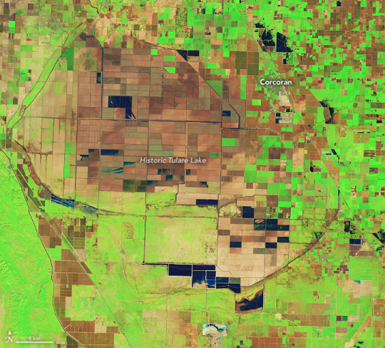
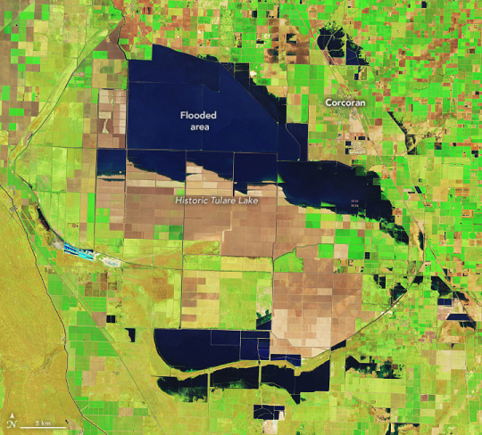
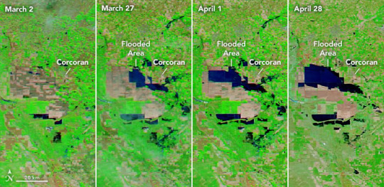

Tulare Lake Grows The San Joaquin Valley sits like a bowl at the base of the southern Sierra. Close to the middle of that bowl is the historic lakebed of Tulare Lake, which was once the largest freshwater lake west of the Mississippi River. Since the 1920s, the rivers that fed the lake have been dammed and diverted for agriculture and other uses. The lakebed has since been covered with farms that produce a variety of crops and livestock. But after two major storms hit southern California in March 2023, water once again returned to Tulare. The image above (centre), acquired by the Operational Land Imager (OLI) on Landsat 8, shows flooded farm fields in the lakebed on April 30, 2023. The image on the top—acquired by the OLI-2 on Landsat 9—shows the same area on February 1, before significant flooding started. These images are false color, which makes the water (dark blue) stand out from its surroundings. Vegetation is green and bare ground is brown. The lower images show the progression of flooding in the Tulare Lake basin. They were acquired by the Moderate Resolution Imaging Spectroradiometer (MODIS) on NASA’s Aqua satellite between March 2 and April 28, 2023. Flooding in the lakebed is likely to continue into 2024, which will affect residents and farmers in the area, as well as some of the most productive cropland in the Central Valley. The lakebed contains farms that produced cotton, tomatoes, dairy, safflower, pistachios, wheat, and almonds. The town of Corcoran, on the edge of Tulare’s historic extent, is at risk of flooding from the rising waters. A 14.5-mile L-shaped levee stands between the farm town and the flooding. The community recently began a project to raise the height of the levee by 4 feet, to prevent the levee from being overtopped. Meltwater from the snowpack on the southern Sierra—which was four times the average in April—is a major source of water for the Tulare Lake basin. Sierra meltwater streams into Kern River, which flows from the Sequoia National Forest in the southern Sierra, past Bakersfield, and ultimately empties into Tulare Lake. Along the way, the river also contributes to Lake Isabella, a dammed reservoir in Sequoia National Forest that has been filling with water this year. High levels of water along the Kern have led managers to discharge water from the river into ponds just west of Bakersfield. Flooding these recharge ponds allows water to seep into aquifers for long-term storage. The graphic below shows these flooded ponds on April 30, 2023, compared to February 1. The images were acquired by the OLI on Landsat 8 and the OLI-2 on Landsat 9, respectively. “All the dark blue water you see is being managed in recharge ponds,” said Kern River watermaster Mark Mulkay, after seeing the images. In anticipation of more meltwater coming down from the Sierras, local and federal water managers are releasing water into ponds like these not only to store water for future use but also to prevent uncontrolled flooding along the river and the Isabella Reservoir to the east. “This early water recharge will keep flood water from the Kern out of Tulare Lake to help minimize the flood damages in that area,” Mulkay added. Snowpack in the Sierras is not finished delivering challenges to the San Joaquin Valley. Spring snowmelt has just begun, and according to the May 1 snow survey by the California Department of Water Resources, snowpack on the entire range is still twice the normal level. NASA Earth Observatory images by Lauren Dauphin, using Landsat data from the U.S. Geological Survey and MODIS data from NASA EOSDIS LANCE and GIBS/Worldview. Story by Emily Cassidy.
12 notes
·
View notes
Text
Final Theme Project Proposal
Road Trip to Fresno, CA
The primary focus is to explore the captivating landscapes, diverse infrastructure, and hidden gems surrounding Fresno, CA, through a photography journey that celebrates the spirit of road trips.The intention is to capture the diverse topography of Central California, ranging from the Sierra Nevada foothills to the expansive agricultural plains that define the region. I will also capture smaller events and places that encapsulates Fresno such as colleges and farmer markets.
There are many places in Fresno, CA that someone can go on a road trip to. One such location near Fresno is Millerton Lake which is surrounded by tall mountains. Millerton Lake, which is northeast of Fresno, is a reservoir with a capacity of about 520,500 acre-feet, formed by the Friant Dam on the San Joaquin River. This water serves as part of the Central Valley's water supply and flood control. The lake also has a surface area of approximately 5,000 acres and an elevation of 561 Feet. Another location I will photograph are farmer markets showing the agricultural significance in Fresno. One farmers market I will visit is the River Park Farmers Market, which happens weekly on Tuesday and Saturday at River Park. It is also Fresno's Favorite Certified Farmer's Market for more than 20 years.
My approach on capturing these photographs won't require much planning, except setting time aside to drive and make it to the locations. Being as nearly all of the journey will be outdoors and on the road, there isn't much of a need for permission. Sadly, my gas budget will increase from all the driving.
As a resident of Fresno my whole life, I have been on dozens of road trips with family. So the reasoning of this project is to show anyone who might want to live in Fresno, or pass by, things to look forward to and appreciate in this valley. Through this project, I aim to highlight the unique charm of Fresno, discovering famous vacation areas and also often-overlooked scenery and cultural richness that make Fresno a truly special place to live or visit.
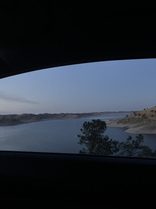
(Millerton Lake, Fresno, CA)
0 notes
Text
Sixth Avenue used to cut through miles of farmland. Now, the road has disappeared under muddy water, its path marked by sodden telephone poles that protrude from the swelling lake. Water laps just below the windows of a lone farmhouse that sits alongside the submerged route.
Thousands of acres of cropland have been inundated in this heavily farmed swath of the San Joaquin Valley. And the water just keeps rising.
For the first time in decades, Tulare Lake is reappearing in the valley, reclaiming the lowlands at its historic heart. Once the largest freshwater lake west of the Mississippi River, Tulare Lake was largely drained in the late 19th and early 20th centuries, as the rivers that fed it were dammed and diverted for agriculture.
This month, after a historic series of powerful storms, the phantom lake has reemerged. Rivers that dwindled during the drought are swollen with runoff from heavy rains and snow, and are flowing full from the Sierra Nevada into the valley, spilling from canals and broken levees into fields that usually teem with lucrative plantings of tomatoes, cotton and hay.
“This is unreal,” said Mark Grewal, an agronomist who has worked on the area’s farms since 1979, surveying floodwaters that stretched to the horizon. “I’m just amazed at how fast it filled.”
...
“The flood isn’t being handled properly,” said Grewal, noting he works with one grower who has 2,400 acres of pistachio trees choking underwater. “It’s a mess, because there are breaks everywhere.”
In one mysterious incident, Jack Mitchell of the area’s Deer Creek Flood Control District alleged that someone had intentionally cut open a levee with a backhoe in the dark of night. He says he knows who did it, but the report hasn’t prompted an investigation.
Elsewhere, Mitchell said, the Boswell company at one point used a massive piece of equipment as a barrier, keeping Mitchell’s crew from cutting into a levee to send water flowing toward the basin bottom and away from towns. “It’s silly the way they’re doing it,” he said at the time. “It wants to go to the lake, and they won’t let it go.”
#california#central valley#tulare lake#water policy#la times#lakes return#drought#drought and deluge
0 notes
Text
California drenched as new atmospheric river brings thunderstorms and winds | California
A new atmospheric river brought heavy rain, thunderstorms and strong winds to California on Friday, raising the threat of flooding and disrupting travel.
Flood advisories or warnings were issued by the National Weather Service for areas around the San Francisco Bay, the central coast and the Sacramento and San Joaquin valleys. Southern California saw generally lighter rain.
The atmospheric…
View On WordPress
0 notes
Text
Bakersfield CA
26 January 2023
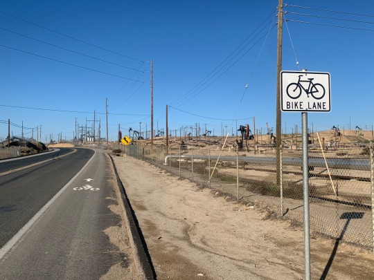
Bakersfield was a convenient overnight on our route south, but certainly not anything I’d consider a destination. It sort of anchors the southern end of the agricultural San Joaquin Valley, acts as a transportation gateway between the Central Valley and the Mojave Desert, and boomed because it sits on top of a lot of oil. The Kern River barely flows here anymore (the past couple of weeks may be an exception). I’ve driven through a few times over the years and I spent a very long afternoon, evening, and morning hitchhiking through Bakersfield in 1976, on my way between Ventura and Lone Pine.

I started at Beach Park (‘beach’ is an aspirational term). One can actually ride a long ways downstream, but I only had so much time and decide heading upstream (northeast) would be more interesting. I followed the Kern River Trail along the south edge of the floodway until it sort of runs out against the Alfred Harrell Highway (about 6 1/2 miles). It’s a good trail. There were some folks walking and a few other cyclists, but not many. As with so many near-urban bike trails and dry riparian corridors, there were a lot of small encampments, overloaded shopping carts, and broken bicycles. It was actually really nice to see a couple of city crews and other teams along the way checking in on folks. It had been an awfully cold night and some of them must have gotten hit hard during the heavy rains and flooding earlier in the month.


I considered just riding back on the trail, but decided to loop back on China Grade Road, through Chevron’s Kern River oilfield. I suppose agriculture is what got Bakersfield started, but it was oil that really transformed the town. This is an old oilfield, cluttered with pumpjacks and pipes and service roads. And that made this a very different landscape than the outbound leg, or of virtually any other bike ride I’ve been on. The shoulder wasn’t great and there were a fair number of trucks and service vehicles, but it was never stressful and the stretch went by pretty quickly. Eventually, I headed south and rejoined the trail along the river for the final three miles back to the car.


1 note
·
View note
Text
I want it i need it i have it lyrics ditch it trash it

Ray Lotto's El Raton was the third place Express 27. "And Rocket's a lot of work." Thirteen Express 27s raced, and Get Happy!! passed Magic Bus in the last few miles to win the division. This year they took Brendan's Express 27 Get Happy!! "I like one design racing," he said. ©2014 īrendan Busch and Ian Klitza sailed the D-Class Cat Rocket 88 the last three years. They finished second out of six Wabbits behind Aaron Sturm's Wild Bunch. This year, the wind softened at the Benicia Bridge and remained mellow the rest of the way.Ĭolin Moore's Kwazy Wabbit along the lazy river. Usually, the wind pipes up in San Pablo Bay, builds in the Carquinez Strait approaching Benicia, builds more in Suisun Bay, and really honks in New York Slough past Pittsburg and Antioch. The Extreme 40 SmartRecruiters flies a hull in San Pablo Bay. These are Magic, Don Quixote and Mistress Quickly, all from Santa Cruz YC. The Santa Cruz 27s eked out a one design division at the last minute with six boats. Nothing to do with the drought, just insufficient depth on a minus tide on the east side of San Pablo Bay. The J/35 Jarlen was the first victim of the water shortage. The first division, Light 1, starts popping chutes right away. The NOE flags were for Noe Goodman, who fell in the water and drowned at Stockton Sailing Club following last year's race. Saturday morning at the Richmond YC docks. The current was shifting from ebb to flood as the divisions started north of the Richmond-San Rafael Bridge, and stayed with the fleet the whole way to Stockton. Many boats were even able to carry past Mark 19 in the usual 'white sail reach' portion of the San Joaquin River. The wind direction cooperated, with spinnakers going up at the start and staying up. The weather was warm but not blazing hot as in some years, with temps peaking in the 80s. A light air year, there was plenty of time for telling jokes, flirting, and quaffing cold beverages out of cans. We’re laughing all the way to the river bankīrad Paisley could have sung those lyrics for this year's Delta Ditch Run, saving the inner tube for Sunday. It ain’t like we really need a million dollar yacht, 'causeīut we have got each other and gas in the tank You know even if our ship came in and this is all we got The normally nukin' New York slough was relatively tame for Saturday's Delta Ditch Run.
0 notes
Text


Grateful Dead
Pressing plate and label for Wake of the Flood album, Side B, ca. 1973
Pressing plate (31.5’’); scratches, scuffs. [With]: Green vinyl disc (4.3’’), with black and white printed labels featuring Grateful Dead logo and illustration of bird, Side A and B track lists, “GD-01 | A” and "GD-01 | B," and copyright “1973 Grateful Dead Records”.
The Dead’s sixth studio album and the first on their independent label, Grateful Dead Records. It had been three years since they’d recorded American Beauty, and Wake of the Flood would be a first for the band: recorded without founding member Ron “Pigpen” McKernan, it featured Keith Godchaux as his replacement on keys. Godchaux’s arrival brought new musical horizons for the band, as his playing drew less on the blues, and more on post-war jazz.
The album was recorded at the newly opened Record Plant in Sausalito, just north of San Francisco. About the time in the studio, Bill Kreutzmann recalled, “The Record Plant was decked out in a classic seventies style, with an array of different-sized pieces of wood covering the walls, just for effect. … Also—and this is pretty cool—the studio was right across the street from the U.S. Army Corps of Engineers Bay Model, which is an actual, miniature hydraulic model of the entire San Francisco Bay and the Sacramento-San Joaquin River Delta. It accurately simulates the tides and was created to study environmental impacts. It turns out, that’s the perfect thing to be looking at when you’re getting high, while taking a smoke break with your friends. We’d walk around its cavernous insides, which mimic the foothills around the Bay—again, the perfect playground for stoned musicians looking to get lost in another world.”
Sotheby’s
4 notes
·
View notes
Link
He is determined to kill or harm us, one way or another......slowly or more slowly or more quickly.
Excerpt from this story from EcoWatch:
1. Tribal Lands
Tribes and environmental groups have fought for decades against a proposed copper mine in an area of Arizona known as Oak Flat, which is a sacred site for a dozen tribes, including the San Carlos Apache. Now the Trump administration is pushing to fast-track a deal that would transfer ownership of the land, which is in the Tonto National Forest, to Resolution Copper, a firm owned by mining companies Rio Tinto and Billiton BHP.
2. Federal Energy Regulatory Commission (FERC) Shakeup
Just days after the election, Trump switched up the leadership of the Federal Energy Regulatory Commission, which has a hand in regulating hydroelectric projects, as well as interstate transmission of electricity, oil and natural gas. Chairman Neil Chatterjee was replaced by fellow Republican James Danly, who has a more conservative view on federal energy policy.
3. Hamstringing Land and Water Conservation Fund (LWCF)
The Great American Outdoors Act, a major conservation bill signed into law in August, allocated $9.5 billion to help fix national park infrastructure and permanently fund the Land and Water Conservation Fund. But despite (falsely) hailing himself as a conservation hero at the law's signing, Trump has already begun undermining the legislation's effectiveness. An order signed by Interior Secretary David Bernhardt on Nov. 9 allows state and local governments to veto any land or water acquisitions made through the fund.
4. Dam Raising
On Nov. 20 the Trump administration finalized a plan to raise the height of Northern California's 600-foot Shasta Dam by 18.5 feet, which would allow for more water storage. The reservoir feeds the federally run Central Valley Project, which funnels water hundreds of miles south to cities and farms. That includes the politically connected Westlands Water District in the San Joaquin Valley, which formerly employed Interior Secretary David Bernhardt as a lawyer and lobbyist. The state of California has strongly opposed the effort to raise the dam's height because it would flood the McCloud River, protected as wild and scenic.
5. Pesticide Changes
The U.S. Environmental Protection Agency (EPA) announced on Nov. 20 it was taking away a tool states can use to control how pesticides are deployed. The action could further endanger farmworkers and wildlife.
6. Migratory Birds
A gutting of the Migratory Bird Treaty Act of 1918 took a big step forward at the end of November, clearing the way for the administration to finalize the rule change by the end of Trump's term.
7. Arctic National Wildlife Refuge Auction
The Bureau of Land Management announced on Dec. 3 that oil and gas leases in the Arctic National Wildlife Refuge would go on sale on Jan. 6, following a shortened time frame for the nomination and evaluation of potential tracts to be drilled.
8. Dirty Air
One week into December, the administration finalized its decision declining to enact stricter standards for regulating industrial soot emissions.
9. Border Wall
The incoming Biden administration has vowed to not build another foot of the border wall, but the borderlands ecosystem remains under threat as the Trump administration is continuing to push ahead. In some cases wall builders are even attempting to speed up the work.
10. Harming Whales and Dolphins
Trump may be leaving office, but marine mammals won't be able to rest easy. NOAA Fisheries issued a rule on Dec. 9 allowing the oil and gas industry to harm Atlantic spotted dolphins, pygmy whales, dwarf sperm whales, Bryde's whales and other marine mammals in the Gulf of Mexico while using seismic and acoustic mapping, including air guns, to gather data on resources on or below the ocean floor.
11. More Lease Sales
The Arctic isn't the only place where the rush is on to exploit public lands. On Dec. 9 the Bureau of Land Management updated an environmental assessment for a 2013 plan for leases to extract climate- and water-polluting tar sands on 2,100 acres in northeastern Utah. But then just days late it hit the pause button on the effort. While that one may be on hold, the administration did kick off the sale of leases for oil drilling on 4,100 acres of federal land in California's Kern County on Dec. 10.
12. Cost-Benefit Rule
One of the administration's biggest parting gifts to industry — the "cost-benefit" rule — was finalized on Dec. 9. It would require the EPA to weigh the economic costs of air pollution regulations but not many of the health benefits that would arise from better protections.
39 notes
·
View notes
Photo

New track from me on this compilation “ PUEBLO SALVA PUEBLO” https://onenightcollective.bandcamp.com/album/pueblo-salva-pueblo-2 This compilation is an emergency project developed by “Ascetic Limited” (Los Angeles, CA / Tbilisi, GE) & “One Night Collective” (HN/UK) to help collect donations for the people affected by “Eta” and “Iota”, two strong hurricanes that battered the country of Honduras and Central America. Honduras is facing probably the greatest catastrophe of its history, the International Committee of the Red Cross estimates the recovery of damaged areas across Central America will take at least two years. No country has been hit harder than Honduras, where at least 3.7 million people, more than a third of the population, have been affected. No region of Honduras has suffered more than the flood-prone valley surrounding San Pedro Sula, the country’s second-largest city and industrial center, where the storms caused the Chamelecón and Ulúa rivers to breach their banks. This compilation Consists in 31 tracks from artists from around the world that have offered their support, their imagination and their precious time. The compilation is available exclusively on “Bandcamp” All the money that this project will generate will be donated to the people of Honduras that are in need of: food, shelter, medicine, clothes, somewhere to sleep and all the basic needs that the government is not offering. This is a simple demonstration of the solidarity that the electronic music scene represents. Artists included: A. Morgan A Thousand Details Altrd Being Arnaud Le Taxier Balto Boyd Schidt Charles01 Craft CRøWN End Train Erik Luebs Eyvind Blix FBK Fixon Frgtten Greenbeam & Leon J Barton & Renwick Joaquin Ruiz Josh Reeves Josh Sturges Kellener Nahualism Means&3rd Mystics Nahualism Phil Denton Ricardo Garduno Romain Richard Secus Takaaki Itoh VYN•1 Worg Wrong Assessment 10EI #technolover #technopeople #technomind #technoparade #technoboy #technofamily #technodj #technoculture #technolife #technoconnectingpeople #minimaltechno #technovibes #music #technosound #electronicmusic #electromusiclovers #electro #acidmusic #technotribe #arnaudletexier #techno https://www.instagram.com/p/CIdeTidggNu/?igshid=1gr7e7mxrbbjw
#technolover#technopeople#technomind#technoparade#technoboy#technofamily#technodj#technoculture#technolife#technoconnectingpeople#minimaltechno#technovibes#music#technosound#electronicmusic#electromusiclovers#electro#acidmusic#technotribe#arnaudletexier#techno
2 notes
·
View notes
Text
SACRAMENTO, Calif. (AP) — California will provide 100% of the water requested by cities and farms for the first time in years thanks to winter storms that filled reservoirs and runoff from a record snowpack, regulators announced Thursday.
The State Water Project will provide full allocations to 29 water agencies supplying about 27 million customers and 750,000 acres of farmland, the Department of Water Resources said.
As late as March, the agency was only expecting to provide 75% of requested water supplies.
The last time the state agency fully met water requests was in 2006.
Meanwhile, the federal Bureau of Reclamation announced it was increasing water allocations for the Central Valley Project to 100% for the first time since 2017.
The move was cheered by contractors who supply the federal water to the state's agricultural heartland. It will provide much-needed water to communities, farms and families in the San Joaquin Valley, said a statement from Jose Gutierrez, interim general manager of Westlands Water District.
"Following two years of 0% allocations, this water supply will assist growers in Westlands with putting the land to work to grow the food that feeds the world,” he said.
Both the state and federal governments control networks of reservoirs and canals that supply water across California.
Three years of drought had pinched off supplies drastically in the nation’s most populous state. Late last year, nearly all of California was in drought, including at extreme and exceptional levels. Wells ran dry, farmers fallowed fields, and cities restricted watering grass.
The water picture changed dramatically starting in December, when the first of a dozen “ atmospheric rivers ” hit, causing widespread flooding and damaging homes and infrastructure, and dumping as many as 700 inches (17.8 meters) of snow in the Sierra Nevada mountains.
The statewide reservoir storage on Thursday was at 105% of the average for the date, the Department of Water Resources said.
The runoff from the melting snow will supply additional water that the state agency said it is working to capture.
As of this week, more than 65% of California no longer had drought conditions, according to the U.S. Drought Monitor.
However, the Department of Water Resources urged people to continue using water cautiously. State officials have warned that in the era of climate change, one extremely wet year could be followed by several dry years, returning the state to drought.
The state water agency noted that some northern areas of the state still have water supply issues. In addition, some areas, including the agricultural Central Valley, are still recovering after years of pumping that has depleted underground water.
“Millions of Californians rely on groundwater supplies as a sole source of water," the agency warned.
“The Colorado River Basin, which is a critical water supply source for Southern California, is still in the midst of a 23-year drought,” the agency added. “Californians should continue to use water wisely to help the state adapt to a hotter, drier future.”
14 notes
·
View notes
Photo


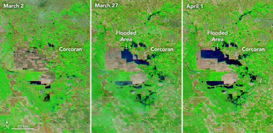
Return of Tulare Lake Tulare Lake, in California’s San Joaquin Valley, was once the largest freshwater lake west of the Mississippi River. The lake would grow every winter as rainfall and snowmelt from the nearby Sierra Nevada range flowed down and filled the basin. By 1920, the rivers that fed the lake were dammed and diverted for uses such as irrigation. Since then, the lakebed has been covered with farms that grow a variety of crops. Heavy rain and snow in the first three months of 2023 has once again brought water to Tulare’s lakebed. On March 29, 2023, the Operational Land Imager (OLI) on the Landsat 8 satellite acquired this image (above centreimage) of agricultural fields near Corcoran covered with water. The image is false color, which makes the water (dark blue) stand out from its surroundings. Vegetation is green and bare ground is brown. The image on the left, acquired by the Operational Land Imager-2 (OLI) on Landsat 9, shows the same area in March 2022. With a population of 22,000 people, Corcoran is the largest city in the vicinity of the historic lake. Many homes in the city have been flooded and several roads have been closed. Smaller towns to the south, Allensworth and Alpaugh, were surrounded by water from overflowing rivers and were both under evacuation warnings as of the end of March. These images (lower) show a wider view of the Tulare lakebed. They were acquired by the Moderate Resolution Imaging Spectroradiometer (MODIS) on NASA’s Aqua satellite and show the progression of flooding between March 2 and April 1. Two successive atmospheric rivers hit California in March 2023, contributing to flooding along the San Joaquin River and a breach of the Los Angeles Aqueduct. “The Tulare basin floods occasionally, especially during extremely wet years and years with abundant snowpack on the Sierra Nevada mountains,” said Safeeq Khan, agricultural engineer and adjunct professor in civil and environmental engineering at the University of California, Merced. Khan noted that the lakebed flooded in 1969, 1983, and 1997. Until this year, 1969 and 1983 held the record for the wettest years with near-record levels of snow in the region. “The basin is a powerhouse for agricultural production and the impact of the flooding is going to be prolonged,” Khan said. “The four counties within the basin—Fresno, Kern, Kings, and Tulare—are some of the top-producing counties in the state.” Khan also serves as an extension specialist for the University of California’s Division of Agriculture and Natural Resources (UC ANR), which helps connect farmers, industry, and communities with the latest scientific research. As of 2022, the lakebed contained farms that produced cotton, tomatoes, dairy, safflower, pistachios, wheat, and almonds. According to the Western FarmPress, the floods in spring 2023 have forced numerous dairies to relocate cattle from the region. Flooding in the region may not let up in the coming months as snow melts from the Sierra Nevada. A snow survey by the California Department of Water Resources (DWR) on April 3 found the statewide snowpack was 237 percent of average for this date, among the largest ever recorded. The size and distribution of this year’s snowpack is posing severe flood risk to some areas of the state, according to DWR, especially in the San Joaquin Valley. NASA Earth Observatory images by Lauren Dauphin, using Landsat data from the U.S. Geological Survey and MODIS data from NASA EOSDIS LANCE and GIBS/Worldview. Story by Emily Cassidy.
2 notes
·
View notes
Text
Natural Disaster Prevention vs Response
To what extent can natural disasters be prevented?
This question is likely to become a critical area of discussion as we plan to respond to the many changes, such as increases in extreme weather events, presented by climate change.
The Director-General for Global Issues at the United Nations, Hans-Joachim Daerr, makes a critical point on this subject in this statement when he argues that, “The consequences of extreme natural events are not, however, disasters to be simply accepted as inevitable. They are the product of natural hazards and the vulnerability of existing social and ecological systems to these hazards. It is often detrimental anthropogenic influences that lead a natural event to become a natural disaster: extreme urbanization in endangered areas, establishment of hazardous industries in risk-prone locations, artificial straightening of river courses and destruction of natural flood plains, deforestation and soil erosion, and a lack of awareness and dearth of knowledge of existing risks” (Federal Foreign Office, 2004).
In order to address these vulnerabilities, it is critical that communities as well as critical decision makers prioritize disaster prevention rather than solely disaster response. This concept can be further explored by examining a case study of the San Joaquin Delta.
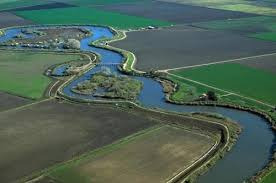
The San Joaquin Delta is a roughly 700 mile long winding waterway which is fed by runoff from the Sierra Nevada Mountains and Southern Cascade Mountain ranges. Approximately one-third of the Delta’s water feeds into the San Francisco Bay Area. This crucial watershed runs through California’s capital city of Sacramento and has approximately 1100 miles of levees which protect the surrounding areas from flooding. These levees are subject to breakdown or failure due to events such as erosion, storms, and seismic activity, like earthquakes. The vulnerability of these levees has been well documented and yet remains under addressed.
If these levees were to break, not only would surrounding communities be flooded, but much of the surrounding farmland near the Delta, which is lower in elevation than the Bay Area, would be flooded by salt water threatening critical food supply for a large population.
This is a major vulnerability for California in terms of being a potential natural disaster. Plans for preventing this catastrophe must be prioritized over response plans. Efforts for prevention can include: the use of setback levees to widen waterways in order to increase surface area for flooding, supporting local communities in raising their homes, schools, and essential service buildings such as grocery stores and hospitals, and ensuring that sufficient floodplains are available if massive flooding were to occur. By increasing the resiliency of the communities that surround the Delta water system, we will ensure that adequate effort has been made to reduce the threats posed by a devastating flood. It is through the prioritization of planning for events such as strong storms and flooding, that we can potentially move their categorization from a natural disaster to a natural event.
by: Chelsea Thomas
Written for ESPM 194
Quoted resource:”Are Disasters Inevitable? The disaster reduction strategy of the Federal Foreign Office” 2004
Photo Credit: CA Department of Water Resources (water.ca.gov)
1 note
·
View note
Last Seen Blogs