#EarthObservatory.NASA.gov
Text
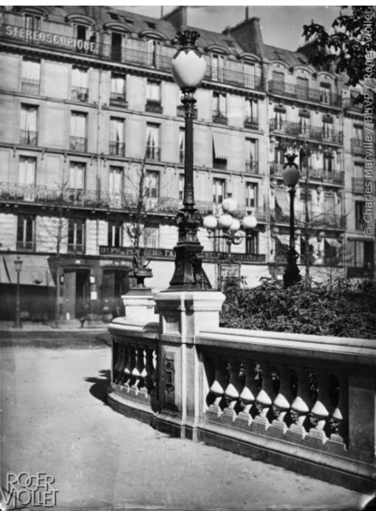
NASA Earth Observatory: Another Eruption in Iceland
FromEarthOrbit, #PlanetEarth, #OurHomeInSpace, #TheOverviewEffect
Hot stuff! 🌋
Satellites measured the infrared heat signature of three recent volcanic eruptions in southwestern Iceland. The first two lava flows appear black, while last week’s eruption radiates heat, which appears red/orange in this #Landsat image - #NASAEarthObservatory
#Iceland Volcano#NASA Earth Observatory#SW Iceland#Volcano heat signature#Landsat Image#Reykjanes Peninsula#EarthObservatory.NASA.gov
0 notes
Text
Please read
I've been protesting since i was two. I have memorised the chants, the speeches, the songs, the same arguments over and over and *over* again. I have signed over 500 petitions, i have attended over 150 marches, I have presented over 10 speeches personally. I don't remember when I learned about climate change because i always knew, so why didn't others?
I remember asking my Mother when i was around eight where she first learnt about it. When she was in year 8, back in 89-90. She said to me "I remember my teacher explaining it to us and thinking 'why isn't anyone doing anything'" She told me it's not that we don't have the answers, its we don't have the materials.
Now I know that is code for "the government is refusing to fund this" or "The government doesn't believe this is an issue" ect ect. Again and again, a new issue that needs to be solved or address or fixed before "we can focus on climate change"
Let me tell you ***You can not fight every battle*** But I try to. This latest "stunt" [Aliens aren't real] by the USA is yet another distraction from the biggest issue, The Atlantic ocean is facing a collapse.
Due to amount of cold water coming from the melted Greenland Ice sheets, It will cause the Atlantic meridional overturning circulation (AMOC) to collapse and shut down.
The last time this happened was around 15,000-14,500 years ago, at the end of the last ice age. It lead to a collapse of weather cycles, temperatures plunge and spike, ecosystems to collaspe.
If it collapses, La Niña could become the norm for Australia.
You can do something. I know because I've done something. So do it.
https://www.zmescience.com/science/major-atlantic-ocean-current-could-collapse-due-to-climate-change/
https://www.gzeromedia.com/gzero-north/warming-seas-have-scientists-on-alert
https://edition.cnn.com/2023/07/20/world/greenland-ice-sheet-melt-sea-level-rise-climate/index.html
https://www.realclimate.org/index.php/archives/2023/07/what-is-happening-in-the-atlantic-ocean-to-the-amoc/
https://earthobservatory.nasa.gov/images/151638/wasting-away-again-in-greenland
#climate change#clean energy#climate strike#climate emergency#climate action#climate catastrophe#climate crisis#climate justice#climate activism#greenland ice sheet#global warming#aliens#USA#politics
233 notes
·
View notes
Photo

Analysis of satellite imagery shows how the war in Ukraine has affected crop harvesting along the front lines
by u/Geographist
Tools: Python, Bash, QGIS/GDAL
Data: Analysis from NASA’s Harvest Program
More info and satellite imagery: https://earthobservatory.nasa.gov/images/150590/larger-wheat-harvest-in-ukraine-than-expected
62 notes
·
View notes
Photo
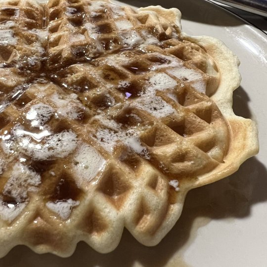
The Earth Waffles: a celebration guide
As our ancients observed and modern science has confirmed, the Earth has an axial tilt and rotates around the Sun in an elliptical path.
This is what allows for the days of more sunlight hours during Summertime and less sunlight hours during wintertime (relative to ones particular location on Earth). These are called equinoxes and solstices.
The Earth waffles back and forth through out the year on its’ annual laps around the Sun and this is what inspires and informs our The Earth Waffles celebrations.
We have four celebrations yearly;
Eatster: the Spring Equinox
YummerTime: the Summer Solstice
FallWaffle: the Autumn Equinox
Wafflenalia: the Winter Solstice
These varies, slightly, depending where on Earth you happen be celebrating and is information that can be easily obtained and verified through the usual respected sources:
https://earthobservatory.nasa.gov/images/52248/seeing-equinoxes-and-solstices-from-space
What do we do to celebrate the Earth waffling back and forth?
We consume waffles as close to the local time that applies to your meal times.
An example of a Spring equinox;
Monday, March 20, 2023 at 15:23.
03:23 PM isn’t typically a good time for a meal but it does allow easily for a dinner of waffles.
Celebrations can include the making of the waffles but the goal is to consume the waffles as close to the time of as applicable.
Consuming waffles as close to the local applicable time will put in the best possible mindset for upcoming portion of the year. Take your time. Enjoy the process.
They can be extravagant waffles or simple waffles. Can be chicken and waffles, can be waffle with Nutella. Waffle cones count. Those little rolls waffle sheets with the ends dipped in chocolate, they count as well.
8 notes
·
View notes
Text

Unusual dust off Chile
July 8, 2016
http://earthobservatory.nasa.gov/IOTD/view.php?id=88358&src=iotdrss
5 notes
·
View notes
Text
Sirene Project
Gemma and Ian chat to Tatyana Dacostagomez and Kaitlin Scowe. Both work for “The Sirene Project”, a platform that highlights and connects female conservationists from all walks of life, to inspire one another, exchange ideas and to be a resource for the next generation of ocean conservationists.
SOCIAL MEDIA LINKS
Leoni: IG @leoni_caro
Kaitlin: IG @howzitscowen
Tatyana: IG @sharkgirltatyana
IG: @thesireneproject
Facebook: @TheSireneProject
Website: www.thesireneproject.com
Oceanic Women's Club
IG: @oceanicwomensclub
OTHER LINKS TO ITEMS DISCUSSED ON THE PODCAST
HM Coastguard - https://www.gov.uk/government/organisations/maritime-and-coastguard-agency
Ford Nugget - https://www.ford.co.uk/vans-and-pickups/transit-custom/nugget
Dive Project Cornwall: www.crowdfunder.co.uk/p/dive-project-cornwall
Reef Word: https://reef-world.org/blog
The Great Barrier Reef: https://earthobservatory.nasa.gov/images/149724/the-great-barrier-reef-through-time
Waterhaul: https://waterhaul.co/
Lundy Diving - https://www.lundydiving.co.uk/diving/
Broads Authority: https://www.broads-authority.gov.uk/boating/navigating-the-broads/broads-rangers
Please give us ★★★★★, leave a review, and tell your friends about us as each share and like makes a difference.
Contact Gemma and Ian with your messages, ideas and feedback via The BiG Scuba Bat Phone +44 7810 005924 Or use our social media platforms.
We are on Instagram @thebigscuba
We are on Facebook @thebigscuba
We are on Twitter @the_big_scuba
The BiG Scuba Website www.thebigscuba.com
Amazon Store : https://www.amazon.co.uk/shop/thebigscuba
New episodes of The BiG Scuba Podcast go live on a Monday around noon UK time - Hit the subscribe button so you don’t miss out.
The BiG Scuba Podcast is sponsorship and ad free thanks to the monthly financial support of patrons.
Visit https://www.patreon.com/thebigscubapodcast and subscribe - super quick and easy to do and it makes a massive difference. Thank you.
🎧You can listen to the BiG Scuba Podcast on all major podcast platforms including …. iTunes, SoundCloud, Spotify and Stitcher 😀
ISSN Number 2752-6127
Check out this episode!
2 notes
·
View notes
Text
https://earthobservatory.nasa.gov/images/152452/americas-sinking-east-coast

YOUR GOP!
"PAY NO ATTENTION TO THE GROWING LIST OF INSURANCE COMPANY'S LEAVING COASTAL STATES"! THE MADE UP GOD WILL SAVE YOU LIKE LAST TIME! ALL YOU HAVE TO DO IS PRAY AND REPENT! REPENT AND PRAY

0 notes
Text
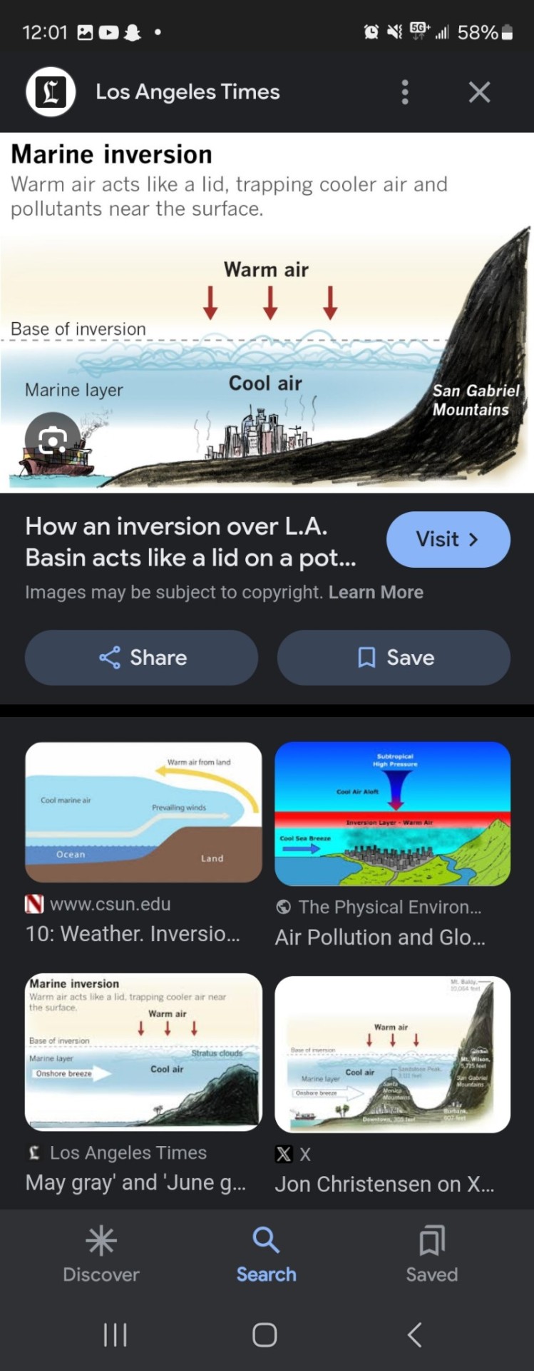
The Gulf of Mexico is critical to the Midwest and East Coast... Because the jet stream runs from west to east but that affects more of the temperature of America. The Gulf of Mexico feeds all the way up through Canada and into the Arctic. It supplies us with oxygen and all forms of moisture. And this is a serious problem because oxygen levels have come down in the Gulf of Mexico, the water and this supplies lots of oxygen into America, Canada and the Arctic. And the smog that is growing in Arizona and California is trapping moisture below it, preventing that from going towards the Midwest and East Coast as well from the Pacific. This is why we have the growing desert and this is why we have many more droughts in California and in effect, Mexico as well. So the Pacific is the most polluted ocean. So America is getting screwed. The lamp that goes the other way. That's more about the British Annette. The jet stream goes through America towards Britain and the golf moves moisture up and through and the Atlantic does bring it up. But it's from the South outside the Gulf and the Southern states. And then the Gulf and the Southern states, the moisture moves upward. To the top of the world... So America is having serious issues because of the pollution in the Gulf and the Pacific.
National Oceanic and Atmospheric Administration (.gov)
https://www.noaa.gov › news-release
Larger-than-average Gulf of Mexico 'dead zone' measured
Aug 3, 2021 — Exposure to hypoxic waters has been found to alter fish diets, growth rates, reproduction offsite link, habitat use,
So because of smog building up in the West, you and the Pacific being so polluted Moisture isn't rising and this is why the California mountains are not experiencing enough snow.
The Guardian
https://www.theguardian.com › feb
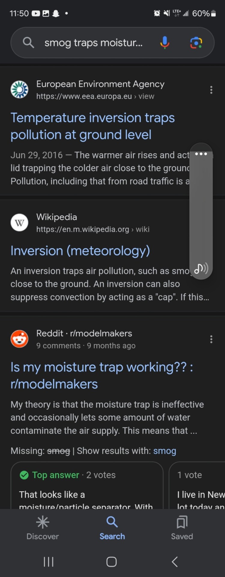
Temperature inversions are trap for moisture and pollution
Feb 29, 2016 — During the day, a lid of warm clear air traps cloud, mist and moisture in the cool air below
Why does smog get trapped?
The warmer air rises and acts as a lid trapping the colder air close to the ground. Pollution, including that from road traffic is also trapped, so the air layer closest to the ground becomes more and more polluted. This continues until the prevailing meteorological conditions change.Jun 29, 2016
https://www.eea.europa.eu › view
Temperature inversion traps pollution at ground level
It's critical that these mountains get very heavy snowfalls because the water runs down stream and it takes care of all the vegetation and wildlife and it also takes care of all the aquatic life... It also allows for good summer rains.As it evaporates it turns into clouds and those clouds bring rain... So the monsoons had been getting less and that means things have been getting dryer...
In 2024, California's mountains have experienced record low snow, with the Sierra Nevada experiencing 52% of average snowpack in the second snow survey of the year. This is less than half of the snow the region typically receives by this point in the winter, and has raised concerns of a "snow drought".
Washington Post
Mountains in the West have a lot less snow than they should right ...
Jan 5, 2024 — Even with a small uptick in recent days, the California region SWE is less than half the normal value for the date, according to the U.S. Agriculture Department's Natural Resources Conservation Service. The SWE of 3.2 inches on Jan. 4 compares to the normal 7.2 inches. In what became a historically snowy winter, last year the SWE was 11.2 inches on the same date.
earthobservatory.nasa.gov
A “Surprisingly Average” Year for Sierra Snowpack
Apr 11, 2024 — After more than a decade of either unusually wet or unusually dry years, snowpack in the Sierra Nevada was close to normal in 2024. Snowpack throughout the Sierra range was 110 percent of average on April 1, 2024, according to the California Department of Water Resources (DWR).
San Francisco Chronicle
Here's where California's snowpack stands with winter ...
Jan 30, 2024 — California has received barely half of the snow it typically gets by this point in winter, reinforcing concerns of a “snow drought” as the wet season moves into its second half and time grows shorter to produce cold, powder-producing storms. State water officials reported 52% of average snowpack across California's high country in the second snow survey of the year on Tuesday, a day before a major storm was forecast to bear down on the state and at least slightly improve prospects for the season, particularly in the southern Sierra Nevada. Another big storm is expected to arrive Sunday.
The 2023-2024 winter has been marked by a periodic warming of the eastern tropical Pacific, known as El Niño, which has torqued winter weather across much of the Western Hemisphere. Many of California's storms this year have been warm, with rain falling instead of snow.
However, snowpack throughout the Sierra range was 110 percent of average on April 1, 2024. Angelique Fabbiani-Leon, California's state hydrometeorologist, said that several additional storms within March would help, and that the region would be up to 100% of average by April 1.
At the Central Sierra Snow Lab at Donner Pass, Calif., October through December snowfall in 2023 was the fourth-lowest since 1971. “No horrible records just yet, but we are certainly scraping the bottom of the barrel at this point,” Andrew Schwartz, lead scientist and manager of the lab, said in an interview.Jan 5, 2024
https://www.washingtonpost.com › ...
Mountains in the West have a lot less snow than they should right
So this is causing things to have hotter and hotter temperatures in Arizona Nevada. It's affecting Utah and many other areas growing the desert region because of the pollution in the Pacific Ocean. And then the smog in California, preventing water from getting warmer and rising. As you see, the inversion traps this air below. And it prevents the water vapors from coming up... So and it's causing a problem as well.In arizona for the water to move westward the smog in scottsdale tempe area again is trapping the water in the valley and it's causing the valley to get hotter and hotter.... And this also trapped pollution.And this makes air quality worse in Arizona, California.Because it traps all the pollution below.It so literally they're killing themselves... Yes, they're killing themselves because it traps and prevents rainfall from coming in and washing it out. It prevents a snowfall from happening and cleansing. The sky and the traps all that pollution towards ground level. The smog prevents the pollution from getting the sunlight and getting evoperate. It and so literally, California's opportunities of poisoning themselves and people in Arizona are poisoning themselves.....
The National Weather Service said the monsoon season this year in the arid Southwest dropped only 0.15 inches (. 38 centimeters) of rainfall from June 15 to September 30. That's the driest since the agency began keeping records in 1895. The previous mark was 0.35 inches in 1924.Oct 1, 2023
https://www.voanews.com › phoen...
Phoenix, Arizona, Has Driest Monsoon Season Since 1895
Yes, monsoon rainfall has decreased in Arizona in 2023, with Sky Harbor International Airport receiving 0.15 inches of rain from June 15 to September 30, which is the driest monsoon season since 1895. This is a decrease from 2022, when 10.63 inches of rain fell, and 2021, when 10.90 inches fell.
VOA News
Phoenix, Arizona, Has Driest Monsoon Season Since 1895
Oct 1, 2023 — October 01, 2023 7:20 PM. A jet takes flight from Sky Harbor International Airport as the sun sets over downtown Phoenix, Arizona, July 12, 2023. Phoenix, Arizona — After a summer of extreme heat, Arizona's most populous city is in the record books again. This time Phoenix is notching a record for dry heat. The National Weather Service said the monsoon season this year in the arid Southwest dropped only 0.15 inches (. 38 centimeters) of rainfall from June 15 to September 30. That's the driest since the agency began keeping records in 1895. The previous mark was 0.35 inches in 1924.
The Guardian
Phoenix has driest monsoon season since record-keeping ...
Oct 2, 2023 — Monsoon 2023 was officially the driest on record in Phoenix with a grand total of 0.15" of rainfall recorded at Sky Harbor International Airport. The average during the monsoon season is typically 2.43". # azwx pic.twitter.com/3bdC728IK3. — NWS Phoenix (@NWSPhoenix) October 1, 2023. Nevada has struggled with drought conditions since 2020. New Mexico, the fourth driest state in the US with an average annual rainfall of about 14in (35.5cm) per year, also has been affected by the drought in recent years. Phoenix this summer experienced the hottest July and the second-hottest August.
AZCentral
Arizona's 2023 monsoon driest on record for Phoenix - AZCentral
Sep 29, 2023 — At the high country's airport, 2023's accumulation of 4.24 inches puts it well below its average of 7.68. The year was also dwarfed in comparison to 2022 (10.63 inches) and 2021 (10.90 inches). In Phoenix, Sky Harbor caught an abysmal 0.15 of an inch of rain this season, easily placing it as the driest on record, pushing out 1924 at 0.35 of an inch. Usually, Sky Harbor gets around 2.43 inches of rain during the season. When compared even to 2020's "Nonsoon," a total that both Tucson and Flagstaff handily exceeded, Phoenix's 2023 comes nowhere close. Sky Harbor got exactly 1 inch of rain that year, according to NWS statistics.
The 2023 monsoon season was also the 20th-warmest on record, with Phoenix experiencing its hottest July and second-hottest August. The lack of rainfall has been driving the heat higher, as when the sun shines on dry ground, more of its energy is converted into heat.
Most of the southwestern U.S. experienced drier than normal monsoon conditions in 2023, especially across central and southern Arizona into New Mexico and west Texas, with most areas receiving 50% or less of normal precipitation. However, precipitation in the north and west offset the drier areas.
Precipitation totals vary widely each monsoon season and within each season, amounts change quite dramatically from city to city. For example, during the 2013 monsoon season, Flagstaff recorded well above normal monsoon season total precipitation, while Prescott was almost two inches below normal.
So literally these people on the west coast are killing themselves... But in every city they don't understand this pollution is trapping pollution below it causing poorer and poorer air quality...
Inversion is a weather phenomenon where warmer air at higher altitudes traps colder air — and pollution — below it, according to the Utah Department of Environmental Quality.
The Gulf of Mexico's moisture can cause snowfall in Canada through low-pressure systems that move east or northeast. These storms use moisture from the Gulf of Mexico and cold air from Canada to create heavy snow and sometimes blizzards. The moisture from the Gulf of Mexico and tropics also helps the Prairies experience fluffier snow and heavier snowfall rates in the spring.
NOAA National Severe Storms Laboratory
Severe Weather 101: Winter Weather Forecasting
These storms move east or northeast and use both the southward plunge of cold air from Canada and the northward flow of moisture from the Gulf of Mexico to produce heavy snow and sometimes blizzard conditions. Other storms affecting the Midwest and plains intensify in the lee of the Canadian Rockies and move southeast.
The Weather Network
How the tropics help produce big springtime snows on the Prairies
Apr 23, 2022 — MUST SEE: Spring weather words you need to know. There's still plenty of cold air locked over Canada deep into March and April, even as classic springtime storms bring comfortable warmth and rowdy thunderstorms south of the border. These low-pressure systems cross the border with plenty of atmospheric moisture pumped straight from the Gulf of Mexico and tropics to the south, providing the juice needed for fluffier snow and heavier snowfall rates across the Prairies, both of which contribute to deeper accumulations. The increased moisture doesn't just increase the tenacity of blizzards on the eastern Prairies.
The Gulf Stream, also known as the Atlantic meridional overturning circulation (AMOC), is an ocean conveyor belt that moves heat, nutrients, and water from the tropics to the North Atlantic. This is responsible for the relatively mild temperatures in European countries that are roughly on the same latitude as Canada.
CBC
https://www.cbc.ca › m_blog › ten...
10 Strange Facts About Canada's Climate - The Wild Canadian Year
Through blistering cold winters to hot muggy summers; torrential rain, blinding snowstorms, deadly tornados and scorching drought
So as you see it's causing serious issues are pollution.... It is destroying the united states.....


https://www.sltrib.com › 2022/02/09
What causes inversions in Salt Lake City? And what's behind ...
0 notes
Text
Destacan la necesidad de conectar las áreas protegidas para facilitar la adaptación de la biodiversidad ante los eventos climáticos extremos
Han estudiado 32 parámetros de los eventos climáticos extremos históricos y los que se prevén para lo que resta de siglo en el Caribe
investigadores del Museo Nacional de Ciencias Naturales (MNCN-CSIC) y la Universidad de Évora han analizado cómo han afectado los eventos climáticos extremos en el pasado y qué efectos tendrán en el futuro en el Caribe y Centroamérica. A través de 32 parámetros que miden el efecto de ciclones, olas de calor, lluvias torrenciales o sequías han comparado como afectarán en la región estas perturbaciones tanto en zonas que cuentan con algún tipo de protección ambiental como las que no. Los datos muestran que las áreas protegidas estarán más expuestas a las olas de calor o los ciclones que otras zonas que no gozan de esa protección, por eso los investigadores alertan de la necesidad de adaptar las estrategias de conservación a los eventos climáticos extremos que se esperan y tratar de interconectar los espacios protegidas.
Históricamente, la región caribeña y centroamericana sufre seguías, lluvias torrenciales o huracanes con regularidad, sin embargo, en lo que va de siglo, estos eventos extremos han incrementado su intensidad y frecuencia de 2 a 3 veces. Algo que se prevé que seguirá aumentando debido a la alteración del clima que provoca la actividad humana. “Hace medio siglo ecosistemas característicos del Caribe y Centroamérica como los manglares o el bosque seco tropical no solo mitigaban el efecto de los huracanes o las olas de calor, sino que eran capaces de recuperarse, pero con el aumento de su frecuencia e intensidad, cada vez lo tienen más complicado”, explica el investigador del MNCN Miguel Bastos Araújo. “Nuestras estimaciones apuntan a que aproximadamente el 65% de la zona estudiada sufrirá en lo que queda de siglo al menos una sequía más intensa y prolongada en el tiempo que las sufridas hasta ahora. A eso hay que sumar el efecto de otros eventos extremos, de ahí que la situación requiera la toma de medidas lo antes posible”, continua.
Imagen del Parque nacional de los Everglades (EE.UU). La imagen de la izquierda fue tomada en marzo de 2017. A la derecha fue tomadaen diciembre del mismo año, tras el paso de un huracán. / NASA https://earthobservatory.nasa.gov/images/92033/nasa-mapping-hurricane-damage-to-everglades
Entre los 32 parámetros que han estudiado para este trabajo se encuentra la intensidad, duración y frecuencia de las olas de calor terrestres, los huracanes, las lluvias torrenciales y las sequias. “La tendencia de las últimas décadas nos muestra que la duración e intensidad estas perturbaciones climáticas va en aumento y la previsión para el futuro es que estos eventos serán más intensos y frecuentes”, comenta Araújo. Con el aumento de la exposición a eventos extremos urge replantearse las estrategias de adaptación y mitigación climática que existen en la actualidad. “Las estrategias actuales para proteger la biodiversidad frente al aumento gradual de la temperatura pueden no ser eficaces, ya que una mayor recurrencia y duración de los fenómenos extremos puede no dar a las especies tiempo suficiente para recuperarse y adaptarse”, explica el investigador de la universidad de Évora, Juan David González-Trujillo.
Comparación de la exposición anual a eventos climáticos extremos dentro y fuera de áreas protegidas desde 1952 hasta 2100 y bajo 3 trayectorias de emisiones de carbono atmosférico (azul, la exposición a eventos climáticos extremos es significativamente mayor fuera de las áreas protegidas que dentro; rojo, la exposición es significativamente mayor dentro de las áreas protegidas que fuera. La falta de una barra indica que no hay diferencia significativa entre eventos climáticos extremos dentro y fuera de las áreas protegidas).
Comparación de la exposición anual a eventos climáticos extremos dentro y fuera de áreas prot...
View On WordPress
0 notes
Text

https://earthobservatory.nasa.gov/images/152511/amazon-forest-fires-rage-in-roraima
0 notes
Text
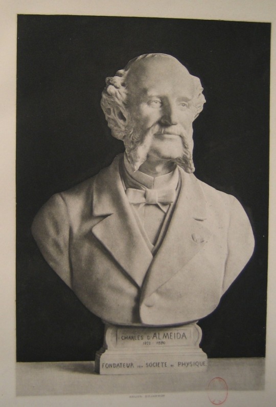
Anaglyphs by Joseph Charles d'Almeida (Paris 1822 – Paris 1880).
I was distantly related to the physicist from Almeida who was a great uncle of my grandfather, what I have left of him are photos representing him...
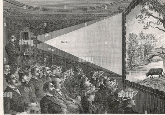
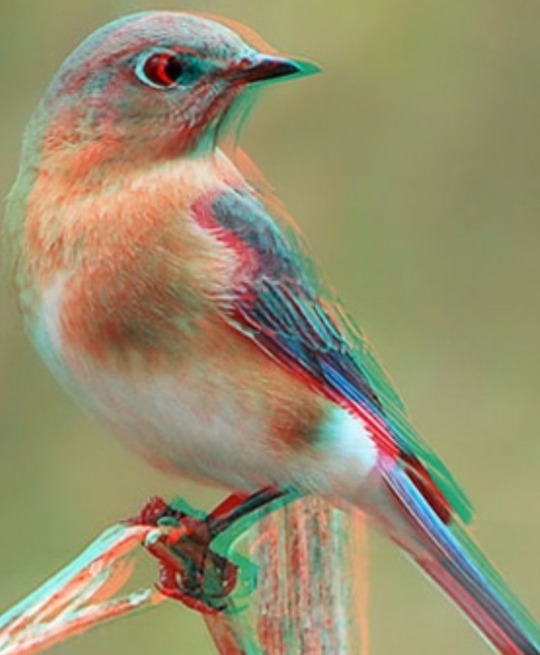
The first public projections of stereoscopic views were made possible thanks to the invention of Joseph Charles d'Almeida. The latter projects the images through a magic lantern using colored filters and distributes glasses with these same filters (red and green) to the spectators. This invention was perfected and is still used today in the so-called anaglyph process. (1).
In 1858, the French physicist Joseph – Charles d'Almeida invented the first relief slide projection process, anaglyphs. For the selection of left and right images (stereoscopic pair), two complementary colors are used, red and blue (cyan). This process with red and cyan glasses is still used today. (2).
The photographer specializing in stereoscopy, Isaac Georges Lévy (Hégenheim 1833 – 1916 Paris) had his stereoscopic photo workshop in Paris (Cf. Photo from the Roger Viollet Collection), the photographer Roger Viollet cannot be in a paper medium for reasons legal. (3).
During the late 1850's, Joseph Charles d'Almeida had been developing a way to view images in 3 D by using the anaglyph method. He and Louis Ducos Du Hauron (Langon 1837 – 1920 Agen) gave the first anaglyph presentation in 1858, using makeshift color lenses as 3D glasses. (4).
Through Stereoscopy, Laes Anaglyphes, MM Charles d'Almeida, Mr. Georges Lévy and Mr. Gabriel Lppmann (1845 – 1921) are among the pioneers of stereoscopic photography which will give rise to relief films. (5).
Joseph Charles d'Almeida (Paris 1822 - Paris 1880) proposed in 1858 relief projection on screen, in anaglyuph, according to Rollman's process, using two projectors (two "magic lanterns") equipped with red filters and green or yellow and cyan. (6).
In 1858, Joseph Charles d'Almeida, a physics professor at the Lycée Henri IV in Paris, invented a method for showing stereoscopic images to several people at once using a lantern projector equipped with red and blue filters. . Spectators wore red and blue glasses. (7).
Stereoscopy invented by Charles Wheatone in 1838 has many variations but only the process using color filtering, developed by the German Wilhelm Rollman in 1853 and later called anaglyph, makes it possible to print in a single image, which can be of large format, the information necessary for relief vision, which is obtained by means of filter glasses. Charles d'Almeida presented this technique at the Paris Academy of Sciences in July 1858 and was interested in its improvement. His research will open the way to strobostereoscopy, a method applicable to cinema and using the alternation of filtered views of two complementary colors. (8).
Research by Franck d'Almeida.
Source :
(1): Press kit Chamonix d’Antan in 3D (October 18, 2014 – March 29, 2015° Contact: Lucinda Perrillat – [email protected]
(2): https://areq.net/lang/fr/Cin%C3%A9ma_en_relief.html
(3) https://www1.alliancefr.com/actualites/autour-du-photographe-isaac-georges-levy-6050838, article by Franck d’Almeida.
(4) https://id.pinterest.com/pin/during-the-lat-1850s-josph-dalmeida-had-been-developing-a-way-to-view-images-in-3d-by-suing -the-anaglyph-method-h--20336635798181228
(5) http://judaisme.sdv.fr/perso/industrie/glevy/glevy.htm
(6) https://www.image-en-relief.org/stereo/193-glossaire
(7) https://earthobservatory.nasa.gov/blogs/earthmatters/2016/11/21/what-on-earth-is-an-anaglyph. & www.almyimages.fr.photos-images/magic-lantern.html?sortBy=relevant
(8) Text by Franck d'Almeida in the Bulletin of the Friendly Association of Former Students of the Lycée Henri IV. September 2021.
Les Anaglyphes par Joseph Charles d'Almeida (Paris 1822 – Paris 1880).
J'ai eu lointaine parenté avec le physicien d'Almeida qui fut un grand oncle de mon grand père, de ce qu'il me reste de lui c'est des photos le représentant...
Les premières projections, en public, de vues stéréoscopiques sont rendues possibles grâce à l'invention de Joseph Charles d'Almeida. Ce dernier projette les images à travers une lanterne magique utilisant des filtres colorés et distribue aux spectateurs des lunettes disposant de ces mêmes filtres (rouge et vert). Cette invention a été perfectionnée et est encore utilisée aujourd'hui dans le procédé dit anaglyphe. (1).
En 1858, le physicien français Joseph – Charles d'Almeida invente le premier procédé de projection de diapositive en relief, les anaglyphes. Pour la sélection- des images gauche et droite (couple stéréoscopique), deux couleurs complémentaires sont utilisées, le rouge et le bleu (cyan). Ce procédé à lunettes rouge et cyan est encore actuellement utilisé. (2).
Le photographe spécialisé en stéréoscopie, Isaac Georges Lévy (Hégenheim 1833 – 1916 Paris) avait son atelier de photo stéréoscopique à Paris (Cf. Photo de la Collection Roger Viollet), la photographe Roger Viollet ne peut pas être dans un support papier pour des raisons juridiques. (3).
During the late 1850's, Joseph Charles d'Almeida had been developping a way to view images in 3 D by using the anaglyph method. He and Louis Ducos Du Hauron (Langon 1837 – 1920 Agen) gave the first anaglyph presentation in 1858, using makeshift color lenses as 3D glasses. (4).
Par la Stéréoscopie, laes Anaglyphes, MM Charles d'Almeida, M. Georges Lévy et M. Gabriel Lppmann (1845 – 1921) font partie des pionniers de la photographie stéréoscopique qui donnera naissance aux films en reliefs. (5).
Joseph Charles d'Almeida (Paris 1822 – Paris 1880) a proposé en 1858 la projection en relief sur écran, en anaglyuphe, selon le procédé de Rollman, à l'aide de deux projecteurs ( deux « lanternes magiques ») équipés de filtres rouge et vert ou jaune et cyan. (6).
En 1858, Joseph Charles d'Almeida, professeur de physique au Lycée Henri IV à Paris, a inventé une méthode permettant de montrer des images stéréoscopiques à plusieurs personnes à la fois à l'aide d'un projecteur lanterne équipé de filtres rouges et bleues . Les spectateurs portaient des lunettes rouges et bleues. (7).
La stéréoscopie inventée par Charles Wheastone en 1838 connaît de nombreuses variantes mais seul le procédé utilisant un filtrage des couleurs, élaboré par l'allemand Wilhelm Rollman en 1853 et plus tard appelé anaglyphe, permet d'imprimer en une seule image, qui peut être de grand format, l'information nécessaire à une vision en relief, que l'on obtient au moyen de lunettes filtrantes. Charles d'Almeida présente cette technique à l'Académie des Sciences de Paris en juillet 1858 et s'intéresse à son perfectionnement. Ses recherches vont ouvrir la voie de la strobostéréoscopie, méthode applicable au cinéma et utilisant l'alternance de vues filtrées de deux couleurs complémentaires. (8).
Recherche par Franck d'Almeida.
Source :
(1) : Dossier de presse Chamonix d'Antan en 3D (18 octobre 2014 – 29 mars2015° Contact : Lucinda Perrillat – [email protected]
(2) : https://areq.net/lang/fr/Cin%C3%A9ma_en_relief.html
(3) https://www1.alliancefr.com/actualites/autour-du-photographe-isaac-georges-levy-6050838 , article par Franck d'Almeida.
(4) https://id.pinterest.com/pin/during-the-lat-1850s-josph-dalmeida-had-been-developping-a-way-to-view-images-in-3d-by-suing-the-anaglyph-method-h--20336635798181228
(5) http://judaisme.sdv.fr/perso/industrie/glevy/glevy.htm
(6) https://www.image-en-relief.org/stereo/193-glossaire
(7) https://earthobservatory.nasa.gov/blogs/earthmatters/2016/11/21/what-on-earth-is-an-anaglyph. & www.almyimages.fr.photos-images/magic-lantern.html?sortBy=relevant
(8) Texte de Franck d'Almeida dans le Bulletin de l'Association Amicale des Anciens Elèves du Lycée Henri IV . Septembre 2021.


Envoyé depuis l'application Mail Orange
#Fédérationfrancaisedephotographie#Societefrancaisedephotographie#nasa#edpsciences#cnrs#societefrancaisedephysique
0 notes
Text
Works Cited
Clarke, Harry. “Illustration for Goethe's Faust.” Mutual Art, https://www.mutualart.com/Article/The-Faust-Narrative--Hubris-Revisited/566D2759A33831F3
Marlowe, Christopher. “The Tragical History of Doctor Faustus.” Project Gutenberg, https://www.gutenberg.org/cache/epub/779/pg779-images.html
“Planetary Motion: The History of the Idea that Launched the Scientific Revolution.” NASA, https://earthobservatory.nasa.gov/features/OrbitsHistory
“Selection of Medieval British Bible Pages.” Antiquities, https://www.antiquities.co.uk/shop/manuscripts/selection-of-medieval-british-bible-pages/
0 notes
Text
Halloween. Is it a win?
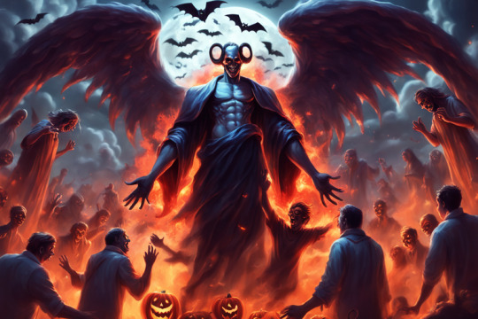
This is for awareness and just a little bit of good read. Not intended to be a downer:
Halloween, celebrated each year on October 31, originated with the ancient Celtic festival of Samhain1. The Celts, who lived 2,000 years ago in the area that is now Ireland, the United Kingdom, and northern France, celebrated their new year on November 11. This day marked the end of summer and the harvest and the beginning of the dark, cold winter, a time of year that was often associated with human death1.
Celts believed that on the night before the new year, the boundary between the worlds of the living and the dead became blurred1. On the night of October 31, they celebrated Samhain, when it was believed that the ghosts of the dead returned to earth1. To commemorate the event, Druids built huge sacred bonfires, where people gathered to burn crops and animals as sacrifices to the Celtic deities1. During the celebration, the Celts wore costumes, typically consisting of animal heads and skins, and attempted to tell each other’s fortunes1.
In terms of biblical connections, there are no direct references to Halloween in the Bible2. Some Christians believe that participating in Halloween is a form of involvement in the worthless deeds of evil and darkness, which is forbidden in Scripture: Ephesians 5:7-152. However, others consider modern-day Halloween activities to be harmless fun2. The Bible is actually completely silent on Halloween since it did not exist during the time when the books of the Bible were written3.
It’s important to note that while some people have connected Halloween to earlier pagan celebrations of the new year, Halloween actually has significant Catholic roots. The name itself comes from All Hallow’s Eve – that is, the Vigil of All Saints’ Day, when Catholics remember those who have gone before us to enter our heavenly home.
Halloween has been around for more than a thousand years1. Originally a religious observance, it became increasingly secular over the centuries until its religious trappings all but disappeared1. Today, Halloween is considered a holiday for dress-up and fun, especially for children1.
The custom of trick-or-treating, in which children dress up in costume and solicit treats from neighbors, became popular in the United States in the early 20th century as Irish and Scottish communities revived the Old World custom of “guising,” in which a person would dress in costume and tell a joke, recite a poem, or perform some other trick in exchange for a piece of fruit or other treat1. By 1950, trick-or-treating for candy had become one of Halloween’s most popular activities1. Today, Halloween is one of the biggest holidays for candy sales in the United States, estimated to be more than $3 billion1.
While Halloween may not have direct biblical connections, it has evolved into a community-centered holiday. It encourages creativity through costumes and decorations, brings neighborhoods together through trick-or-treating and parties, and is seen as a fun way to celebrate the fall season. It’s important to note that how one chooses to celebrate Halloween is often a personal decision based on their own beliefs and traditions.
References:
1. history.com
2. learnreligions.com
3. christianity.com
4. vaticannews.va
5. britannica.com
6. earthobservatory.nasa.gov
7. edsitement.neh.gov
8. biblestudy.org
9. britannica.com
10. history.com
11. today.com
12. hindustantimes.com
#HalloweenOrigins
#samhainfestival
#celticnewyear
#allhallowseve
#trickortreat
#halloweencostumes
#halloweencelebration
#communityholiday
#fallseason
#HalloweenOrigins#samhainfestival#celticnewyear#allhallowseve#trickortreat#halloweencostumes#halloweencelebration#communityholiday#fallseason
1 note
·
View note
Text
The ocean has a fever
https://earthobservatory.nasa.gov/images/151743/the-ocean-has-a-fever
0 notes
Text
Hawaiian Wildfires – Maui, Hawaii – August 2023
My prayers are with all the families, friends and businesses in all areas!
Warnings have been activated!
The wildfires are roaring in Maui, Hawaii. Visit: News Flash • Maui County • CivicEngage at mauicounty.gov for more info.
Image Courtesy of mauicounty.gov
More technical information as provided by earthobservatory.nasa.gov:
Image Courtesy of earthobservatory.nasa.gov
See the Fire Weather Zone…

View On WordPress
0 notes
Text
Hey guys! Remember, plagiarism is not cool! So here's where I get all my information from! If you have any more sources I'd love to see them!
https://education.nationalgeographic.org/resource/rain-forest/
https://earthobservatory.nasa.gov/biome/biorainforest.php#:~:text=Precipitation,inches
https://www.activewild.com/tropical-rainforest-plants-list/
Please check out these super valuable resources for more information about your local tropical rainforest!
0 notes
Last Seen Blogs

pinkpkmntrainer
A special kind of stupid :)

dark0ta
Darkota

yuniryka
無標題

fullwarmth
full warmth

shogonu
THE NEXT THING