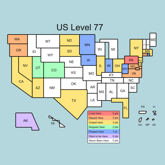
#us map
Text
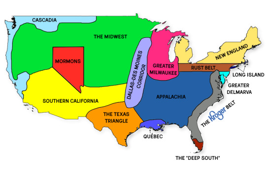
map of US social and cultural regions i made that you can use if you want to start a fight
27K notes
·
View notes
Text
I love how people just randomly decided to do weed when making the states
Alaska is 380 times the size of Rhode island
There's a North Dakota and a South Dakota, a North Carolina and a South Carolina, but Michigan is just Michigan
There's a Virginia, but there's also a West Virginia, which means you can be from west Virginia but not West Virginia
The past two examples mean you can be from south North Dakota, north South Dakota, south North Carolina, north South Carolina, and east West Virginia
Washington DC isn't in Washington
And finally this
11 notes
·
View notes
Text
Idaho and Nebraska need to trade names so we can have all the I states in a line. Iowa, Illinois, and Indiana are all in a row but Idaho just had to go out west all by itself.
#i don't even know how to tage this#united states#iowa#illinois#indiana#maps#us map#organization#idaho
3 notes
·
View notes
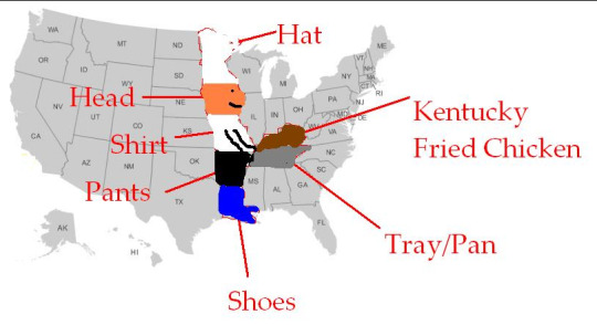
Photo
Indiana - We All Know
15 notes
·
View notes
Photo
A proposal
2 notes
·
View notes
Text
Damn can't wait for the next US DLC

3 notes
·
View notes
Text

Shout-out to one of the first owners of a printed Grasshopper Geography map! This canvas print hangs in the conference room of Headwaters Corporation, a natural resources management consulting firm in Nebraska, whose main focus is habitat restoration for endangered species. The picture is back from 2016, we just found it again :)
If you too have our map displayed on your wall, please contact us or just tag us under your social media posts, we are both so eager to see them! You can also send a picture directly to hello at grasshoppergeography dot com. Thank you for being awesome and for helping us make the world a better place with more colourful maps in it!
#maps#us map#usa map#watersheds#river basin map#river basins#habitat restoration#small business#prints for sale#geography#my art#wall art#map poster
8 notes
·
View notes
Text
I did the thing everyone on twitter is doing because I'm a SHEEP I GUESS
4 notes
·
View notes
Photo
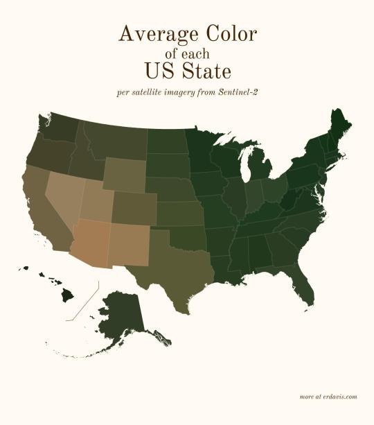
Average color of US states based on satellite imaging.
86K notes
·
View notes
Text
I have been desperately trying to find that tumblr US map with 60 states and the search engines refuse to comply because they're like "60 states is misinformation, there are 50." And now I want to strangle Google but I'm also concerned I hallucinated this hilarious map.
3 notes
·
View notes
Text
Quick name the states of the Southeast?
Because there are states in the South, there are states in East...but there are no states in the Southeast because there no such place in the US! I don't care what anyone said, not even National Geographics!
A few other things wrong here. Texas is it own country basically, if ask most Texans they'd agree. The Southwest is really only New Mexico and half of Arizona (I should know I was born and raised in Southern Arizona). But New Mexico and Arizona is also part of the West. Washington and Oregon should be considered the Pacific Northwest. The following states should not be part of the Midwest, we need to rename them the Middle they are: Oklahoma, Kansas, Nebraska, South and North Dakota. Virginia is not part of the South is part of East in my opinion. The South is from Kentucky down. I truthfully don't know about West Virginia it's a like Texas, but mostly cause it's not completely South or East in culture. That's how I'd break down the map the of America. It's not just about the states placement, but also their cultures, attitudes, lifestyles, ways of thinking, values and so on. You would never confuse a New Yorker (ever if they from Rochester and not NYC) from a Californian. Or someone from Louisiana from someone from Wyoming. Because of how different we all can be. I just think the map should reflect that a little bit, especially when it begins used to teach kids.
#this is no Southeast#what bullshit is this#what are they teaching the children#just look at this mess they've made of the map#map of US so wrong#this only the south#my opinion of what the US should look like#us map
0 notes
Text
Hello Friend, Make it design. it is on all products. we have all products available. everycolour available.
…..
Available products
(clothing, kid & babies, phone cases, stickers, wall art, home & living, stationery &
office, accessories, pets)
…..
our stores
redbubble
teepublic
threadless
[ship worldwide]
stores links
#usa south map#map#usa map#america map#united state of america map#united state of america south map#us map#freedom#rajfa design#usa flage#usa#us#united state of america#design#tshirt#rajfa#funny#graphic design#graphic art#digital art#humor#redbubble#art#armani#prada#barbie
0 notes
Text
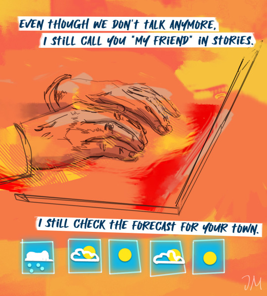
take a jacket just in case
#it's true i use a world meteorological map to see if my ex is in a heat wave lol out of love#ive had this idea in my head forever#my art#digital artists#artists on tumblr#queer art#all my love alright all of it!
36K notes
·
View notes
Text

Now I’m hungry 🧇
1 note
·
View note
Text

The toilets in this kebab restaurant making me feel like I’ve just joined cp_orange_restroom_x3
#orange maps were so good#I used to enjoy mapping for tf2 a fair bit and those orange textures were so aesthetically pleasing#tf2#phonecrap
57K notes
·
View notes
Text
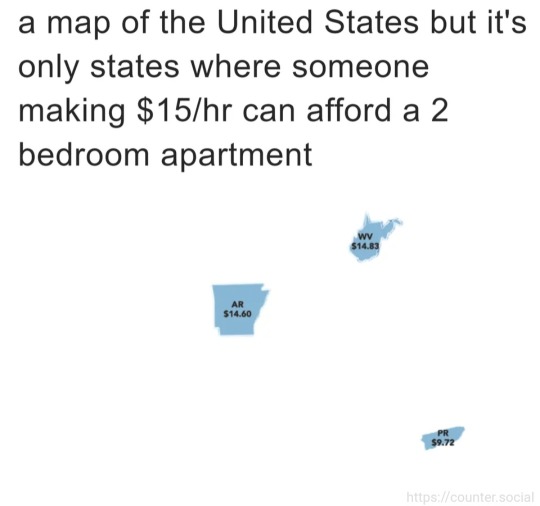
Map of the United States, but only where someone making $15 an hour can afford a two-bedroom apartment.
1 note
·
View note
Last Seen Blogs

papyrus-in-practice
PAPYRUS IN PRACTICE

mikuasukito
Anime For Life

marissarps-blog
sup.

jadowdra
Welcome, Delicious Friend!

xutielly
ray