#qgis
Text
just described qgis as “if photoshop and excel had a baby”
what did i mean
11 notes
·
View notes
Text
New #GIS drinking game - Every time Q/Arc crashes, you take a shot! It's like Russian roulette for your liver with every click!
24 notes
·
View notes
Text
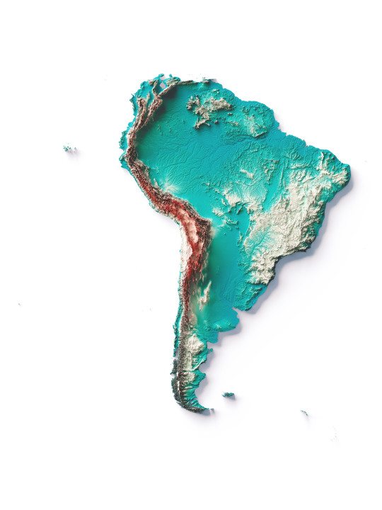
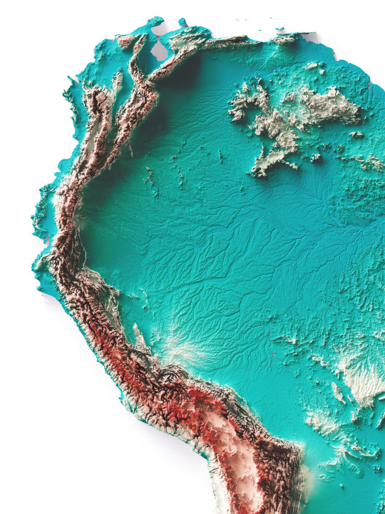
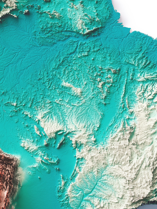
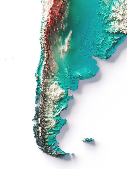
South America, elevation map on Spectral tint.
We have created four colour variants for this continent and would like this combination to become standard.
The red area shows the highest mountains, the Cordillera de los Andes, while the plains are indicated with the colour petrol blue.
If you like our work, want to see our daily updates (or want to say hello to our studio), consider to follow our Instagram or Twitter account. Otherwise if are interested in our prints or have a custom request check our shop.
#mapporn#dataviz#datavisualization#mapart#b3d#blender#qgis#cartography#maps#geography#reliefmaps#reliefmap#3dmapping#mapping#mapartwork#southamerica#southamericatrip#southamericatravel#brazil#braziltravel#argentina#argentinatravel#braziltrip#chile#chiletravel#chiletrip#argentinacampeon#perutrvel#uruguay🇺🇾
97 notes
·
View notes
Text
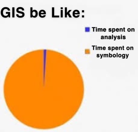
why is the default symbology the ugliest thing ive ever seen like Who want a map that looks like That
2 notes
·
View notes
Video
youtube
Quick OSM effective data collection
2 notes
·
View notes
Text

The final race day of the season is here already. Where did these three months go to? Oh, how it sucks that the season is so short and the off-season so long in this sport.
Anyway, my favourite discipline, mass start, has the honour to bring even this season to an end. The women will be running yet again on the 2.5 km loop while the men are using this 3 km loop (or 2.8 km track according to my measurements). The course design in Canmore is rather interesting in the sense that the 3 km loop has a section that is not used in any other track, the longer tracks included. It makes the downhill after the climb near the shooting range longer, but otherwise it does not add much to the 2.5 km track besides the curiosity.
The track also has a bit longer downhill after the extra loop as it goes further down after going under the bridge of 3.3 km loop and starts to climb up to the stadium there. This makes the 3 km course probably the toughest one in Canmore in terms of shooting. The athletes have a proper 500 metres of uphill before entering the range. This climb might also be the place to make it or break it in the final lap. Who still has gas in their tank when there is 500 metres of season left? We will have to wait and see.
4 notes
·
View notes
Text
Modelling archaeological sites

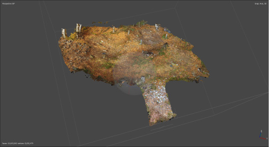
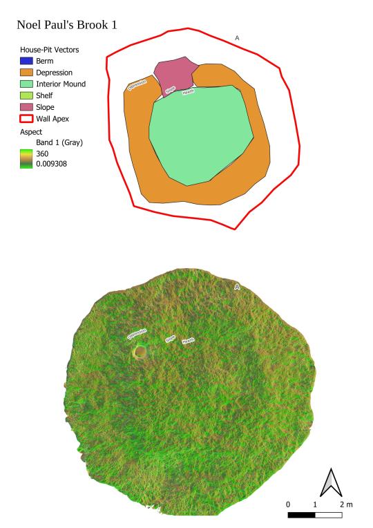
As part of my PhD research, I used drone photogrammetry to make detailed measurements historic Indigenous houses in Central Newfoundland, to examine whether it is possible to detect cultural differences between these based on the remains of their houses.
I take photos like the first one. These are then processed to create 3D models as seen in the second picture. The 3D models are put into QGIS and digitised. But to digitise them, I found that an aspect map, with the slope map draped over it was the best way to interpret the features (as seen in the 3rd photo. This view creates a much more easily interpretable view of the site.
I posted this, because I decided to finish the 30days of maps two days ago, and I didn't get a chance yesterday because I was deep into some PhD work, so here is some of my schoolwork instead.
8 notes
·
View notes
Text
Map of all of the diamond deposits in my world, look out for 35 of these maps in the next week or so
9 notes
·
View notes
Text
Welcome!
I don't know what to put here but I wanted to create a blog of my own.
I'll try to put something here, maybe some passion projects.
About me:
In college, Geodetic Engineering in the Philippines.
Studying to become a surveyor.
I'm a try hard graphic designer.
I'm trying to learn how to use QGIS, so I may post maps.
and maybe some graphic design i guess...
3 notes
·
View notes
Text
My maps for electoral results I'm working on were completely off because I forgot we live in a world where "Number of voters" doesn't correlate 1:1 with "Number of votes"
It's more a 2:1 if anything...
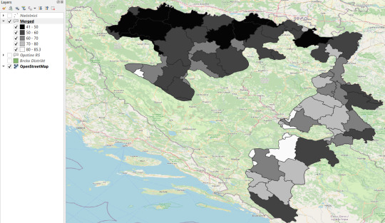
#og post#qgis#keep in mind the north is higher in population thus the deeper black holes in it#I like this breakdown specifically because it shows we do have municipalities where “Didn't vote” won the election#Guess what happens? 2nd place still takes power since you “Didn't vote” and someone has to!#This is what makes election boycotts very funny to me. What did you expect would happen? That people would give a shit about “legitimacy” ?
3 notes
·
View notes
Text
Thoughts at 830...
If you're wondering how our day is going ....
She sent me a zip file called Shapefiles that had all of the .shx, .proj, .dbf and stuff... but did NOT actually have the freaking .shp shapefile!!!!!!!!
We are GIS professionals... we get paid a LOT of money to do GIS stuff... sometimes... we fuck up and forget to send the .shp's
For those who don't know, Shapefiles are a lot like ikea furniture... you need all the parts to make it work. She basically sent me the screws, the funky allen wrench, the instructions, and a nice sticker.... but forgot the actual wood pieces needed to make the bookcase.
3 notes
·
View notes
Text
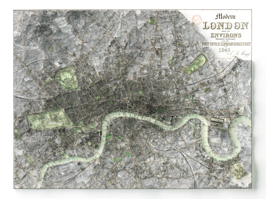
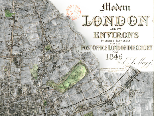
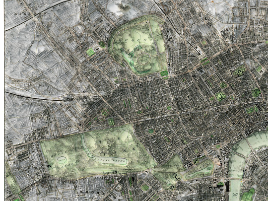
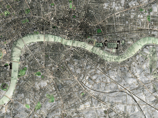
Finally here we go! Another map of a city, and
this time it's London!
It's a map from 1845 and we spent a lot of time in order
to restore it.
We're very pleased with the result we got, but to be
honest we already have more planned, again of
London, and we hope to be able to show them to you
soon.
If you like our work, want to see our daily updates (or want to say hello to our studio), consider to follow our Instagram or Twitter account. Otherwise if are interested in our prints or have a custom request check our shop.
#blender#datavisualization#qgis#geography#mapporn#cartography#mapping#gis#blender3d#dataviz#b3d#map#maps#citytour#citymap#london#londonart#londoncity#londonlife#london🇬🇧#londontravel#londonlove#londonlover#britain#england#londontower#regentspark#hydepark
14 notes
·
View notes
Text

back on my gis bullshit i guess
#qgis#personal#glad to have an excuse to post these memes i made when i had a Crippling crush on my gis ta lolol#gis#attribute table#linking key#not me having to Google literally anything and everything
2 notes
·
View notes
Text
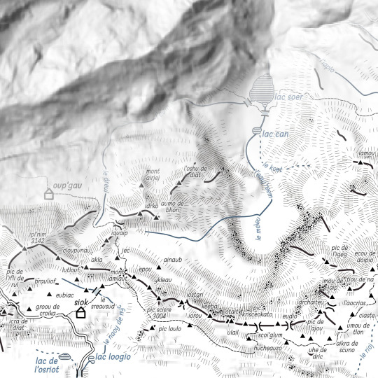
Like old maps. A la façon des vieilles cartes.
Tout est généré, inventé, à partir d'un simple relief...
Ici : Gavarnie revisité.
2 notes
·
View notes
Photo
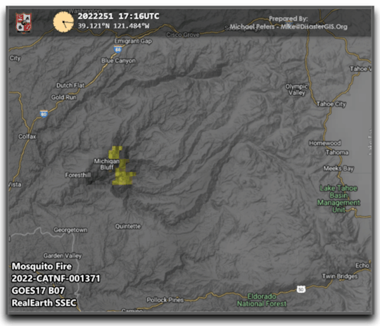
This is a timelapse of the #MosquitoFire near Lake Tahoe using GOES West B07 Enhanced ABI satellite imagery. #GIS #RemoteSensing
#fire#fires#wildland fires#wildfires#brush fires#cartography#gis#mapping#remote sensing#geography#pyrogeography#disasters#qgis#California#Mosquitofire#Lake Tahoe
24 notes
·
View notes
Text
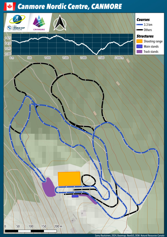
If yesterday I complained about too easy 2.5 km loop in Canmore, today in men's 10 km sprint, the 3.3 km loop is a lot tougher, or at least it has a tough section in it.
The course features a kilometre long downhill which has almost 50 metres of height difference and some speedy curves. After the downhill, the athletes have to climb all these metres back up in two almost consecutive uphills with the combined length of around 800 metres. It truly is a pity that the hills that Canmore Nordic Centre has are not in better use and that almost all of the tracks are made on the flat stadium area.
This course shows that the terrain would have much more to offer in here.
2 notes
·
View notes
Last Seen Blogs

austinshotbutlers
Caught In A Trap

karmander
Just some another tominofag

deep-beneath-the-waves
prince of melancholia

lecturerapture
Untitled

thepictureofjune
— june🪐