#Mount St. Helens eruption 1980
Text

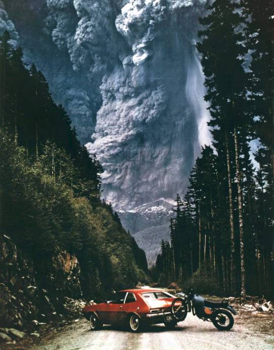
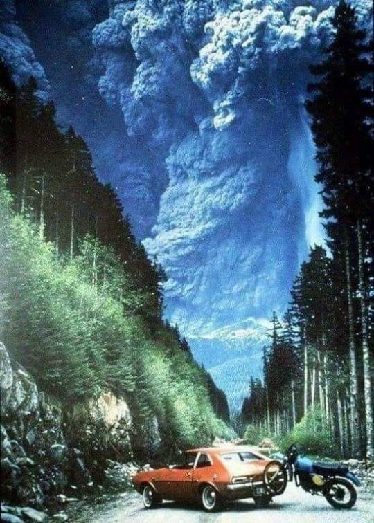
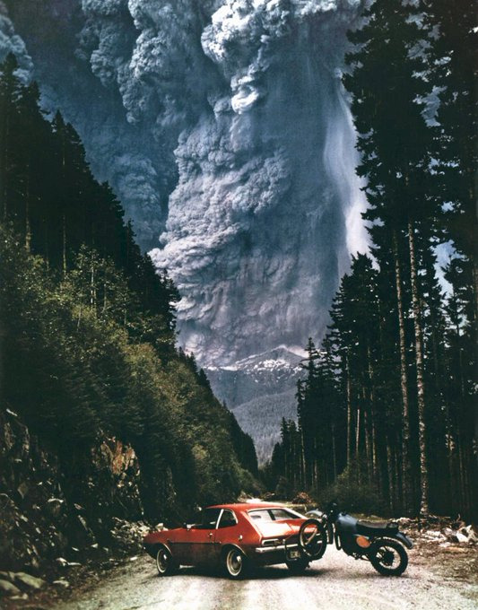
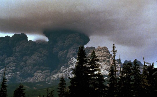
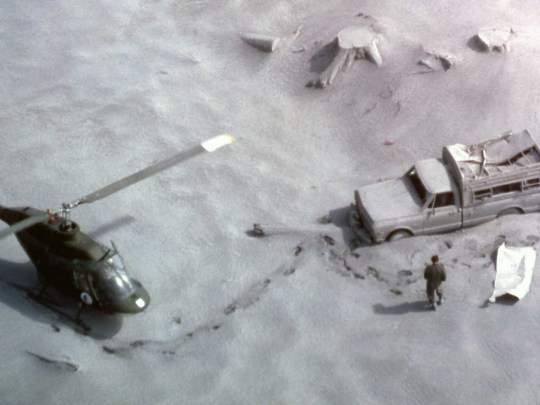
On the morning of May 18, 1980, Richard "Dick" Lasher, vending machine "routeman" and freelance photographer, made this epic photo of the catastrophic eruption of Mount St. Helens. Lasher was forced to abandon his Pinto and flee the giant plume of ash on his motorcycle.
#80s aesthetic#vintage#old school cool#motorcycle#mt st helens#volcano#run away#aesthetic#photography#travel#adventure
368 notes
·
View notes
Text
Mount St. Helens erupts in 1980.
Steve Firth, a friend of the man who took this photo had the following to say:
“...That Pinto and dirt bike belonged to a good friend of mine and when he stopped to turn around, he took this picture. He told me that there was lightning bolts shooting out of the smoke but he didn’t have the right filter on his camera to capture them at that moment. The picture could have been even more amazing.
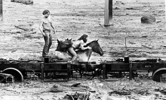
It was used on the TV news and used to be on the cover of Mt. St. Helens brochure at the Johnston Observatory / visitor center. He gave me an original 8×10 copy of it. Although it looked like he was a good distance away from the blast, he barely made it out of there alive.
Had the blast came more in his direction he would have died in seconds. Sometime later he returned and photographed a burned-out pickup with a horse trailer attached to it. He told me he had talked to them that day and said they never made it out. He is a freelance photographer so he took some amazing pictures of the aftermath as well. Anyhow, I thought I’d let you know a bit more about that fabulous picture."
Read more: The Eruption and the Pinto
#Mount St. Helens#volcano#eruption#Richard Lasher#Dick Lasher#Ford Pinto#volcanic eruption#religion is a mental illness
210 notes
·
View notes
Text
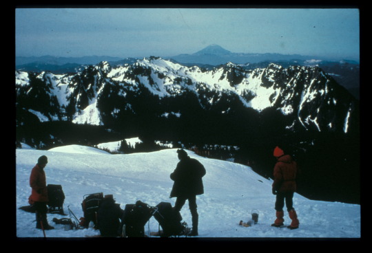
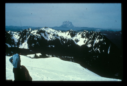
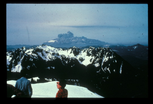
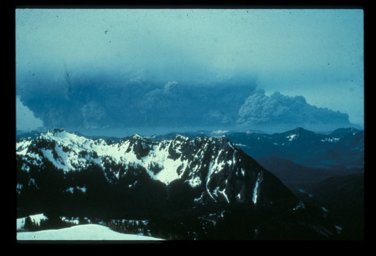
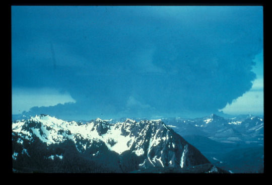
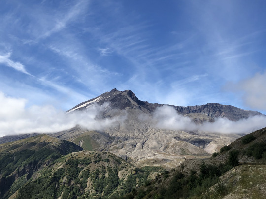
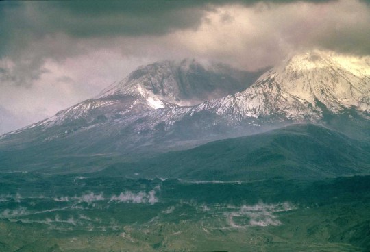
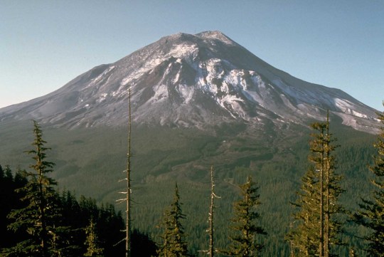
On May 18, 1980, Mount St. Helens, a stratovolcano much like Mount Rainier, erupted. The eruption column rose 80,000 feet (24,400 m) into the atmosphere and deposited ash in 11 states. This series of photos taken from Panorama Point on Mount Rainier captures the main eruption that occurred on this day 44 years ago.
While Mount Rainier is also an active volcano, eruptions do not happen without warning. Much was learned from the Mount St. Helens eruption, and the USGS Volcanoes Cascade Volcano Observatory (CVO) carefully monitors Mount Rainier and other Cascade Range volcanoes. Learn more about Mount Rainier volcano monitoring at https://go.nps.gov/MountRainierVolcanoMonitoring
NPS Photos of Mount St. Helens during the 1980 eruption.
#mount rainier#mount rainier national park#mt st helens#mount st helens eruption#volcano#volcano monitoring
52 notes
·
View notes
Text

Cryptids & Creatures of Folklore Drawtober Day 30 — Batsquatch
Shortly after the eruption of Mount St. Helens in 1980, there were a handful of reports of a strange creature seen flying through the sky in the nearby area. Details were sketchy and varied but most agreed that it had bat wings, a head like a dog or flying fox, an ape-like body, and feet like a bird.
In 1994, a man named Brian Canfield was driving home one night on backroads in Pierce County, Washington. His car suddenly stopped dead in the road and just as he was getting out to check under the hood, a monstrous creature swooped down and landed on the car. Canfield said the humanoid-like creature stood nine feet tall, had blue fur, huge wings, sharp fangs, and a face like a bat. Once it flew away, Canfield's car started again.
Other sightings of this Batsquatch have been reported in the years since, mostly by hikers and truck drivers through the region.
106 notes
·
View notes
Photo
May 18, 1980, Mount St. Helens erupted
161 notes
·
View notes
Photo
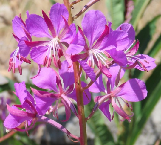
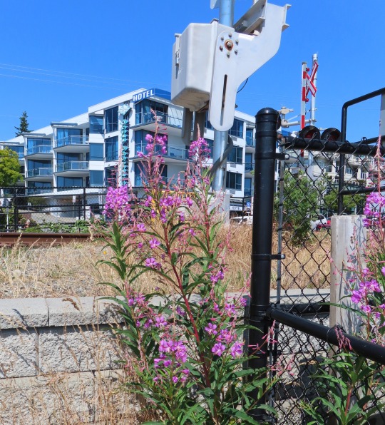
Chamaenerion angustifolium (fireweed)
Fireweed is a classic ‘colonizer’ plant. It’s seeds are carried by the wind and if they land on a patch of open ground, they sprout. Fireweed particularly likes the burned-off lands created by forest fires. When a wild fire scorches the land, it burns off the surface organic material in the soil but leaves behind the minerals. Fireweed stabilizes these fragile mineral soils and the valuable nutrients aren’t simply washed away by the rain. This process makes the minerals bioavailable to all the plants that follow, and eventually produces a healthy and self-sustaining forest.
Fireweed can cover vast areas after a fire and it usually rules the roost for about five years, after which it is overtaken by taller plants. In addition to producing up to 500 seeds a plant, it spreads by underground rhizomes. If another wildfire occurs and burns off this year’s growth, fireweed will rapidly regenerate a new plant from these underground roots. They say that after the Mount St Helens eruption in 1980, fireweed started poking up through the volcanic ash a week later.
I found this fireweed at a railway crossing down by the beach. It appeared to be growing in a matrix of crushed rock and not much else. This lovely specimen had a million-dollar view of the ocean but after all it is a weed. That may be a swanky hotel in the background but this fireweed was definitely growing “on the other side of the tracks.”
#flowers#photographers on tumblr#fireweed#botany#purple#fleurs#flores#fiori#blumen#bloemen#vancouver
125 notes
·
View notes
Text
On May 18, 1980, Richard “Dick” Lasher shot this epic photo of the eruption of Mount St. Helens.
Lasher was forced to abandon his Pinto and flee the giant plume of ash on his motorcycle. Lasher survived.
"It was my fifteen minutes of fame."
25 notes
·
View notes
Text
Keeping an eye out

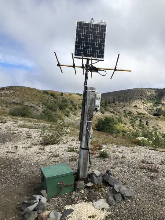
Mount St. Helens is the most active volcano in the Cascades. It's major eruption in 1980 has been succeeded by about 10 other smaller eruptions and maintains near-constant microseismicity. The first pictures show one of the close-in monitoring stations at Windy Ridge. The USGS Cascade Volcano Observatory maintains a number of large monitoring stations close to the mountain, near the vent, where they've been armored to protect from eruptive activity. These stations typically include a seismometer (seismogram here), a GPS station (the white dome), and other equipment like geophones or a webcam. Volcanoes never erupt spontaneously, they are always preceded by some kind of activity - usually small earthquakes - and let you know when they're ready to go. St. Helens hasn't done anything since about 2010, taking a well-deserved rest after the major lava dome growth in 2004-2008.

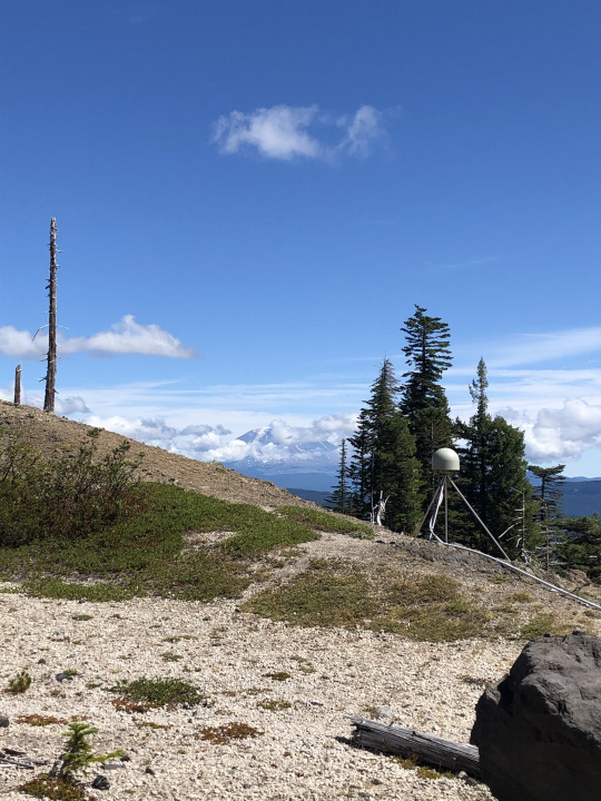
Around the mountain to the southeast, you can hike through the Plains of Abraham's pumice fields and past the slot-canyon head of Ape Canyon to the rim of the Muddy River, where another monitoring station reports seismicity and GPS data. The GPS stations observe the shape of the volcano over time. As gas, fluids, and magma move around inside the mountain, the surface deforms. Rapid or dramatic deformation is often indicative of impending eruption or other activity, and is one of the most important parameters in the volcanologists' arsenal.
#geology#pacific northwest#washington state#washington geology#mount st helens#volcano#cascade volcanoes#gifford pinchot national forest#volcanology#geohazard#loowit#bettergeology#adventures
36 notes
·
View notes
Text


The Eruption of Mount St. Helens, 1980
(https://rarehistoricalphotos.com/eruption-mount-st-helens-1980/)
28 notes
·
View notes
Text

Incredible photograph of the Mount St. Helens eruption on May 18th, 1980
13 notes
·
View notes
Photo


1980s fantasy-themed silver and helenite jewelry by Monica Roi Saxon / MRS Sunshine Enterprises Inc (ad in Dragon magazine #62, June 1982). Helenite is an artificial glass made by fusing ash from the 1980 eruption of Mount St Helens.
D&D inspo: Unique gems might be found around volcanoes, in areas blasted by dragon breath, around portals to the Elemental Plane of Fire, or within fiery outer planes.
#D&D#Dungeons & Dragons#1980s#dragon#dnd inspo#D&D ideas#jewelry#Mount St Helens#helenite#Excalibur#Monica Roi Saxon#MRS Sunshine Enterprises Inc#Dragon magazine#dnd#Dungeons and Dragons
250 notes
·
View notes
Text
Rock Swag Tournament Round 1: Igneous Rocks Part 11
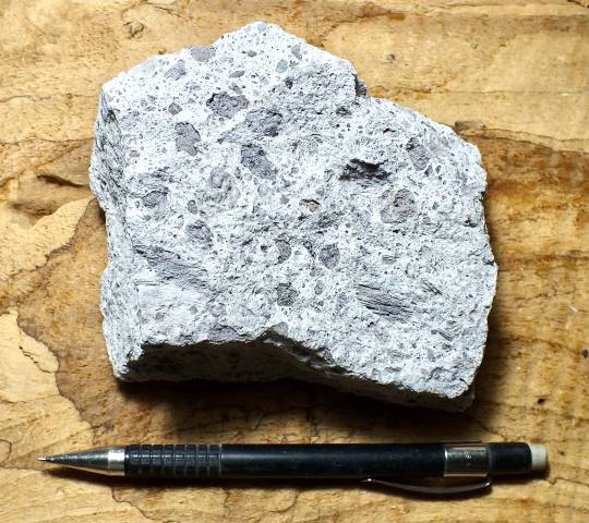
Tuff is an igneous rock...or maybe a sedimentary rock based on who you ask! It is made of lithified volcanic ash (lithification is the process by which particles of stuff become rock, and volcanic ash is sand grain-sized pieces of ejected volcanic matter).

Tuff generally also has pieces of all kinds of other stuff, as well. As long as stuff that is 2 mm or smaller makes up 75% of the rock, it will be considered tuff. Anything less than 75% volcanic ash, and the rock is described as "tuffaceous."
Fun fact: the Moai on Rapa Nui (Easter Island) are made of tuff! Also, according to one submitter, "this is one of the few volcanic rocks that can be made into a really lovely paint. Specifically a vaguely purplish gray" COOL!
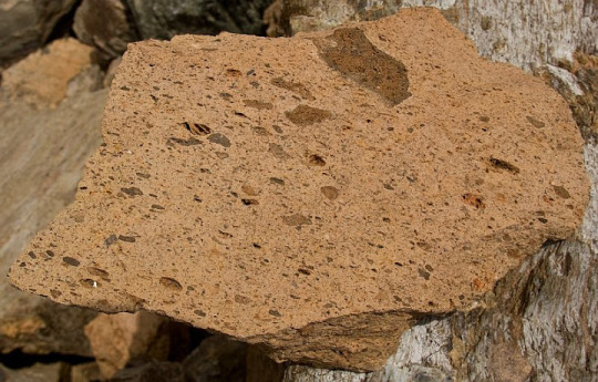
Ignimbrite could be considered a type of tuff, but it is more specifically a rock formed from a pyroclastic flow deposit. Pyroclastic flows are one of the deadliest geological phenomena as they are burning hot clouds of gas and debris that race down the sides of volcanoes during some eruptions!
Ignimbrites can have more and larger pieces of volcanic debris, but they could also simply be tuffs that have welded due to the high heat from an eruption. Ignimbrites also may contain fiamme, which are "flame-shaped" lapilli (volcanic tephra or debris between 2 and 64 mm big) that have been flattened or sheared during deposition.

More on pyroclastic flows under the cut, because they are fascinating in that they are dangerous and I must talk about them.
Pyroclastic flows are blisteringly hot and terrifyingly fast clouds of volcanic gas and assorted tephra: volcanic material that can include ash (particles less than 2 mm), lapilli (between 2 and 64 mm), and blocks and bombs (greater than 64 mm).
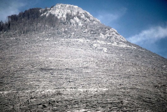
They flow (violently rocket) down the side of volcanoes after explosive eruptions. You generally don't have to worry about pyroclastic flows on Kīlauea any time soon because those eruptions are mostly lava flows (which you can usually outrun). However, some of the most famous volcanic eruptions from recorded human history--Mount St. Helens in 1980, Krakatoa in 1883, and Vesuvius in 79 CE--were accompanied by pyroclastic flows.
Pyroclastic flows can be triggered a number of ways. Some examples are lava domes collapsing and causing an avalanche of sorts, part of the volcano exploding or collapsing in one direction (like Mount St. Helens), or the plume of debris and gas that is shot vertically into the air during an eruption collapsing back down to the surface (like Mount Vesuvius).
There is no outrunning a pyroclastic flow. They flow down the side of volcanoes and across the surrounding landscape at typical speeds upwards of 80 km/h (50 mph), but they can reach speeds of several hundred km/h. These clouds of debris are also several hundred degrees Celsius. You do not survive a pyroclastic flow!
If you would like to see what one of these looks like, I have two videos. Please be warned that because pyroclastic flows are so deadly, one of these two videos discusses deaths related to a specific eruption.
This video is from a documentary (I do not know the name of the film) and the beginning shows the genesis of the pyroclastic flow: the lava dome collapses and causes an avalanche. The pyroclastic flow then moves along a stream valley and close to a nearby town. CW: This video mentions the number of deaths directly related to this eruption and pyroclastic flow. There is footage of a vehicle and a person fleeing the pyroclastic flow, but the town they are in is are far enough away that the pyroclastic flow does not reach their location, and they survive. The potentially triggering part of the video begins at 0:24.
This video shows a pyroclastic flow going into the ocean. CW: As far as I can see, there are no people or animals in the path of the pyroclastic flow in this video and so there are presumably no deaths associated with this eruption.
75 notes
·
View notes
Text
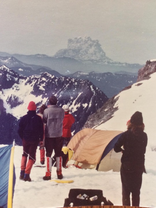
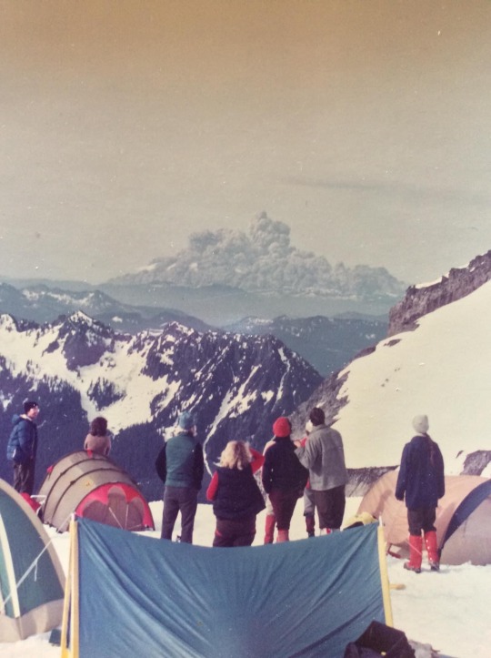
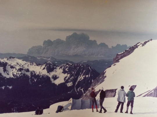
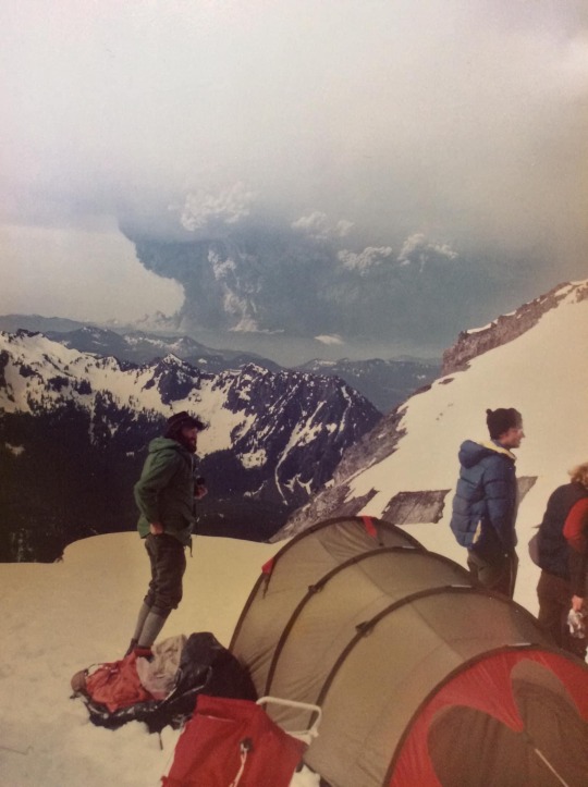
The 1980 Eruption of Mount St. Helens as seen from Mount Rainier
#mount st. helens#volcano#washington#washington state#mountain#mt st helens#photography#mount rainier
157 notes
·
View notes
Text
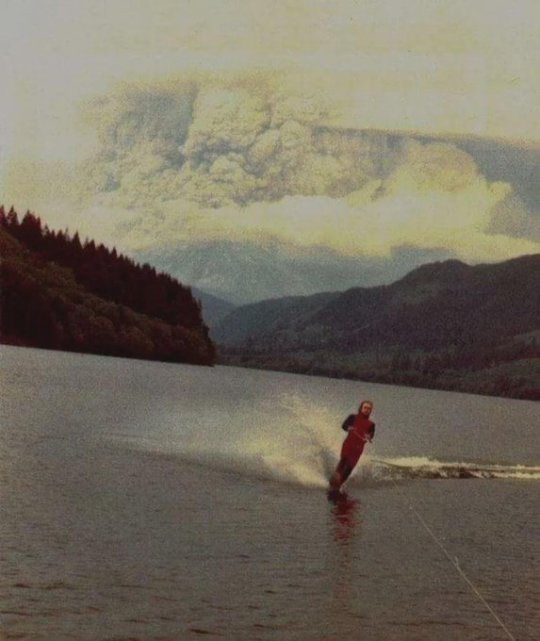
source - https://x.com/Rainmaker1973
Jim Hobson, a 19-year-old resident of Battle Ground, Washington, was water skiing on Yale Reservoir at Saddle Dam Park on May 18, 1980, when Mount St. Helens erupted in the background. The iconic photo captured a surreal blend of thrill and nature's dramatic display. Hobson and his friends, Robert, Ralph, and Dave, had been camping and water skiing in the area, unaware of the volcanic eruption happening nearby. They were camping in a location with no view of the mountain, so when they went out for their morning ski and saw the eruption, they stopped the boat and sat there staring for a while. After that, they moved their camp out on the beach in view of the mountain and spent the day there skiing and watching the eruption. On their way home, there was not a soul around. The area where they had been camping and water skiing was restricted after the eruption.
9 notes
·
View notes
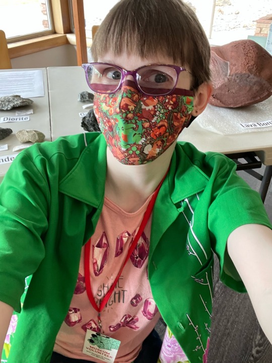
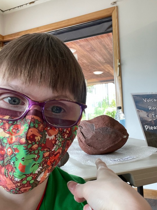
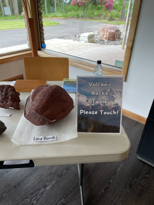
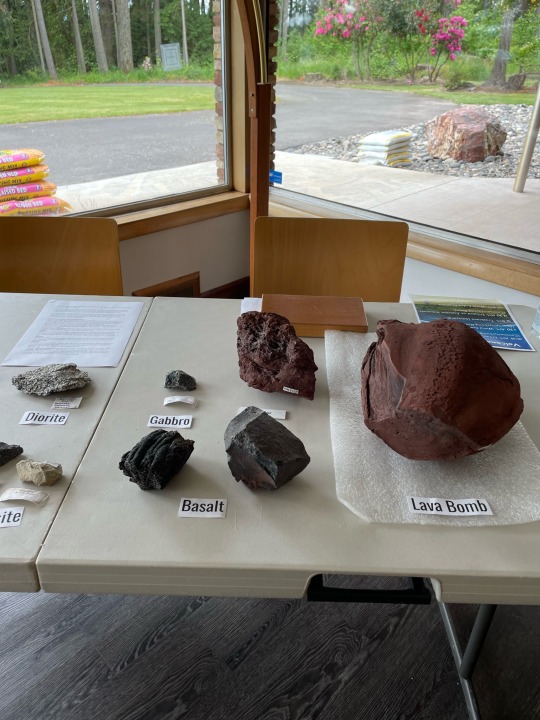
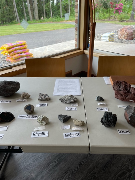
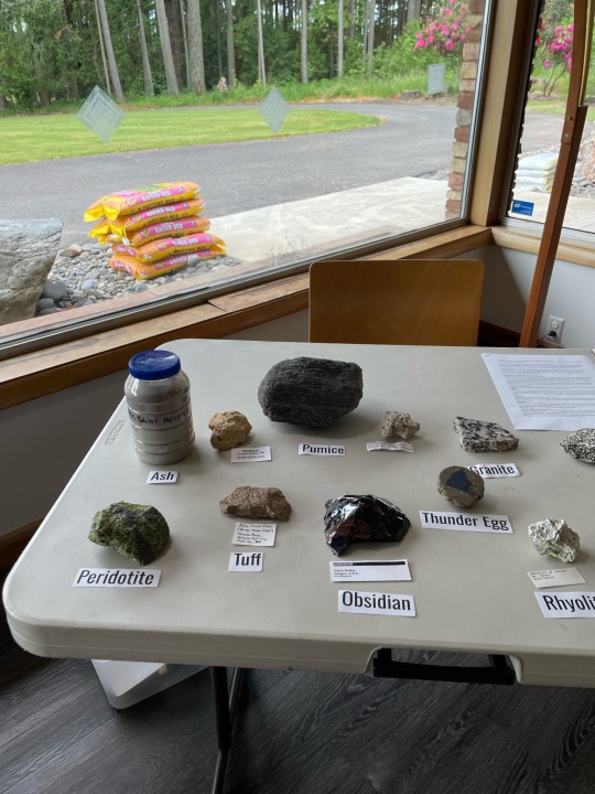
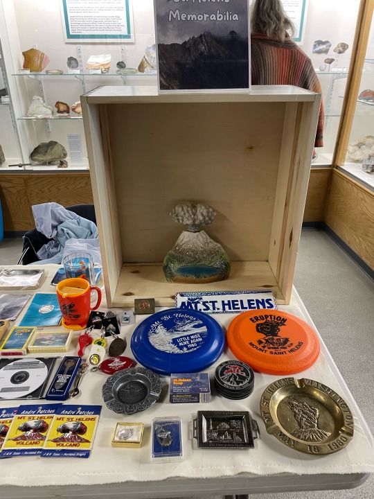
Text
I took part in an event at the Rice Museum for Volcano Day - Here are some of the great pictures of Mount St. Helens memorabilia as this year’s event fell on the 44th anniversary of the May 18th 1980 eruption.
Included is a very special glass known as Helenite.
There are always some videos of our Trashcano eruption.
Look through all the comments to see all the pictures and videos!
https://ricenorthwestmuseum.org/


6 notes
·
View notes
Text
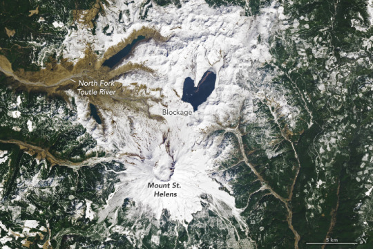
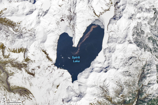
The Lovely Shape of Spirit Lake
"Spirit Lake is resilient. The lake and once-popular tourist site in south-central Washington was nearly obliterated in May 1980 during the events that unfolded around the cataclysmic eruption of Mount St. Helens. The lake survived, and it took on a lovely new shape.
The OLI (Operational Land Imager) on Landsat 8 acquired these images on April 26, 2023. A white blanket of snow contrasts with the dark-blue water, emphasizing the lake’s heart-like shape when viewed from above.
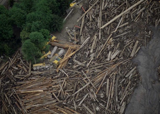
Prior to the eruption, Spirit Lake had a smaller footprint that consisted of west and east arms connected by a narrow span of water—similar in shape to the top-half of a heart. Then, on May 18, 1980, the volcano’s north flank let loose, producing the largest-known landslide in recorded history, followed by a lateral blast and shock wave as the eruption unfolded. The water in Spirit Lake was temporarily displaced but eventually flowed back into the basin.
A “new” lake reformed atop the debris from the landslide. The fully-heart shaped lake was broader and shallower, and the elevation of its surface higher by nearly 60 meters (200 feet). Some of the landslide debris formed a blockage, or natural dam, on the lake’s southwest side. Without an outlet, water levels continued to rise until engineers constructed a drainage tunnel in 1985.
From the 1920s through the 1970s, Spirit Lake drew tourists to its shores. Cabins and lodges lined the lake, and people could swim, boat, and fish in its waters. Today, those lakeside features are buried in avalanche debris below the modern lake.
Fishing and swimming are prohibited, and access is limited to preserve the site as a natural laboratory for studying the landscape’s recovery. For example, scientists think that the trees uprooted by the volcanic blast and still floating in the lake, visible as the brown line in the detailed image above, have become an important part of the lake’s ecosystem."
NASA Earth Observatory images by Wanmei Liang, using Landsat data from the U.S. Geological Survey. Story by Kathryn Hansen.
6 notes
·
View notes
Last Seen Blogs

remyfire
"Go back to sleep. You're dreaming."

mochi-tochi
Bienvenidos, power bottoms!


asterchiild
Aster