#thermal imager data feed
Text
The Dark Eye Continues Its Search

STAR WARS EPISODE I: The Phantom Menace 00:54:57
#Star Wars#Episode I#The Phantom Menace#Tatooine#Mos Espa#DRK-1 “Dark Eye” probe droid#unidentified Mos Espa denizen#GX-8 moisture vaporator#chiller bar#thermal imager data feed#magnetic imaging device#thermal imager#Arakyd Industries#Darth Sidious#Sith holocron
2 notes
·
View notes
Text
Aegis
Chapter 2: Introductions
“Thank you, sir. I will head down there now.”
I tentatively cross the stacks of paper to leave Shein's office, and make my way to the east corridor, dedicated to sector 6. At the checkpoint, I undergo the same security screening I did to enter the building. On the other side of the sealed doors, I'm met with a lanky dark skinned man with wire rimmed glasses. He introduces himself as Zachary Elis, one of the technology Intel specialists in the compound.
Zack escorts me down the hallway to a tall, very muscular man, with buzzed brunette hair. Based on his tactical attire, stun gun, and statue-like posture, I assume he's one of the security guards.
“Hummer, this is Doctor Alexia Wolfe. Shein has assigned her as primary entity observer. Dr. Wolfe, this is Jason Hummer, captain of the sector 6 security division.”
“It's nice to meet you, Mr. Hummer,” I say, extending my hand for him to shake. He glances at my hand and instead offers a curt nod.
“Shein has requested you escort her to each entity for the day”
Hummer grunts in response and turns to lead me down the hall. I hadn't looked down the hall yet. But as I do now, I see that the hallway is lined with heavy tungsten doors. Each door has a hatch beside it with a thick deadbolt, most likely the feeding hatch. We walk down the hallway slowly, and Hummer gives me time to look at the creature through the small glass pane and skim over the entity's file. It takes roughly 20 minutes for us to view the dozen subjects housed in this hall, and I can tell Hummer is not pleased he was assigned babysitting the newbie. Once all 12 entities have been reviewed, I ask Hummer to show me the 3 higher risk entities.
“63. A scaly humanoid lizard with cloaking abilities. Only way to see it then is thermal imaging.
41. A highly intelligent hive minded insect colony. Escapes by strategically sneaking out a few members at a time.
005. One of our first captured entities. Very aggressive canine with a range of transformation stages. Imagine a werewolf that never goes human. 005 has wounded 15 staff in his time here, with 4 of those being fatal.”
“I'm assuming they're fed in a specific way?”
“6:30, morning and evening. Slide the tray through the hatch, bolt the hatch, open the feeding bay door.”
I walk to the room labeled “meal prep” and grab the clipboard off the wall. First day personel feed all of the entities, so they get an understanding of what they're around. Nine of the entities are given a single raw porkchop at each feeding time. Two of them get a single fish filet, and entity 41 gets a paste of blended meat and produce waste.
“This isn't humane. Most of these entities are predators, they need to hunt. Especially for accurate data,” I mutter to myself. I grab the briefing file and look over each entity's eating and digestive data. Pig should suffice for most of them, but I'll need to request chickens for a few. Any scrapps can be cleared from the other enclosures and be given to 41.
I begrudgingly prepare the AEGIS approved meals for each entity and place them on a cart. I wheel the cart from door to door, and stop to watch each entity as the feeding bay doors open. Many of the entities slowly wander their way to the doors, seeming to be bored but knowing they need food to survive. 41 has a good portion of the swarm right outside the doors, and they all march in as soon as the doors open. I suppose the scrap slop is pretty close to how they'd normally eat.
I make my way down the hall to 63 and I hear Hummer call from his post, “Remember to check the thermal” I glance at the control panel and see a button with a flaming iris. When I push it, the glass pane makes everything in the room appear in a rainbow hued infrared image.
In the corner closest to the bay doors is a humanoid heat mass. 63 was planning to dart when the door opened. I slide the tray in and make damn sure the hatch is locked tight before opening the bay doors. Not even 3 seconds later, a loud thud can be heard on the other side of the wall. I start to giggle as I realize 63 just ran headlong into the wall.
Finally I make my way to entity 005. Hummer said he's particularly violent, so I better make sure the doors and hatch are secure. I place 005's tray past the hatch and seal it tight, before glancing through the pane. I'm met with a pair of arctic blue eyes staring directly at me, despite the pane being one way glass. The average looking black wolf then transforms into a tall, bipedal wolf humanoid. He stays back near his makeshift den, but his eyes never leave the tungsten door between us.
I can't tell whether I should be simply weirded out, scared, or if it were merely coincidence. I slide the meat through the hatch and snap the deadbolt in place. I watch with intent curiosity as the bay doors open and 005 distrustfully approaches the tray. When he grabs the slab of meat without anything happening, he relaxes a bit and marches back to his little den. Well, I call it a den. It's more of a pile of blankets spread out beneath a tree covering.
He crouches on top of the blankets and seems to inspect the chop before finally taking a bite. Unlike the other creatures, 005 doesn't tear into his meal like a crazed animal, but rather takes his time. I suppose when you've been here as long as he has, you're in no rush for much of anything. When the meat is gone, he wanders over to the small pond in his enclosure, wading in to about knee deep, and seems to start bathing himself. I turn back to my now empty cart and wheel it back to the food prep room.
@volchistavalkyrie
#black wolf#werewolf#experimentation#x reader#monster fucker#monster boyfriend#monster romance#slow burn
6 notes
·
View notes
Photo


Fuel for Ian, Cool from Fiona Though tropical cyclones are atmospheric phenomena, much of their fearsome power comes from the ocean. The seas are abundant sources of moisture to feed growing storm clouds. Just as critically, they are vast repositories of thermal energy that can move from the sea to the sky. As Hurricane Ian lashed western Cuba and headed for the west coast of Florida on September 27, 2022, it moved over an abundant fuel source in the Gulf of Mexico. While sea surface temperatures are just one of the factors influencing hurricanes, they are a fair predictor of the readiness of the ocean to sustain them. The map above shows sea surface temperatures (SSTs) as measured on September 26 by a combination of satellite and ocean instruments and processed by NASA scientists. Meteorologists generally agree that SSTs should be above 27.8° Celsius (82.04° Fahrenheit) to sustain and intensify hurricanes, cyclones, and typhoons. Surface waters above that threshold are represented in red on the map. Evidence for the transfer of energy between the ocean and atmosphere often shows up in the wake of a storm, literally. As a hurricane or typhoon passes through a parcel of ocean, it can cool the local sea surface for several days. The maps above show sea surface temperature anomalies on September 15 (left) and September 26 (right). They depict how much the surface layer was above or below the long-term average temperature for this time of year. The storm that became Hurricane Earl left a path of cooler water in its wake as it moved across the northwest Atlantic between September 3-10. Then Hurricane Fiona—which traced a path of destruction across Puerto Rico, the Dominican Republic, Bermuda, and Newfoundland—also left a wake as it moved north between September 15-26. Water vapor cools naturally as it rises through the atmosphere and then falls back onto the sea as rainwater. Having given up much of its heat to the atmosphere, the rain cools the sea surface a bit. At the same time, the winds and waves of a hurricane disperse warm surface water and bring up cooler water from the ocean depths. In theory, the cooler water rising to the surface should make it less likely for a new storm to develop or intensify in the same area in the following days. However, the waters of the North Atlantic were not necessarily cool after Earl and Fiona, just at a lower temperature than before. The data for all of these maps come from the MUR Global Foundation Sea Surface Temperature Analysis, produced at NASA’s Jet Propulsion Laboratory. The system combines observations from several satellite instruments, including the NASA Advanced Microwave Scanning Radiometer-EOS (AMSR-E), the Moderate Resolution Imaging Spectroradiometer (MODIS) on the NASA Aqua and Terra platforms, the U.S. Navy microwave WindSat radiometer, the Advanced Very High Resolution Radiometer (AVHRR) on several NOAA satellites, and from in situ observations from NOAA. Editor’s Note: NOAA and other federal and state agencies lead the forecasting of and response to hurricanes in the United States, with NASA playing a supporting role in developing experimental tools and providing key data to those agencies. NASA also works to streamline the flow of information and support foreign science institutions, governments, and international groups as they generate data products from freely available NASA data. The NASA Disasters program contributes with high-value or unique products to complement actions of operational agencies and regional governments to support decision-making during crises and also in disaster risk reduction. NASA Earth Observatory images by Joshua Stevens, using data from the Multiscale Ultrahigh Resolution (MUR) project and information from the National Hurricane Center. Story by Michael Carlowicz.
1 note
·
View note
Text
SAR Solutions Soar: Unveiling North America's Search and Rescue (SAR) Equipment Market Dynamics and Growth Region Forecasts (2024-2032)

Search and rescue (SAR) operations are critical for saving lives and ensuring safety across North America's vast landscapes. As technology advances and the need for efficient SAR operations increases, the SAR equipment market in North America is witnessing significant growth and transformation. From advanced communication systems to specialized rescue tools, the SAR equipment market is evolving to meet the demands of modern search and rescue missions.
In recent years, the North America Search and Rescue (SAR) Equipment Market has experienced steady growth, driven by several factors. One key driver is the increasing frequency and complexity of SAR operations due to natural disasters, outdoor recreational activities, and maritime incidents. As a result, there is a growing demand for advanced SAR equipment capable of enhancing the efficiency and effectiveness of rescue missions.
Another factor contributing to the growth of the SAR equipment market in North America is the technological advancements in SAR equipment. Innovations such as GPS tracking devices, unmanned aerial vehicles (UAVs), and thermal imaging cameras have revolutionized SAR operations, enabling responders to locate and rescue individuals more quickly and safely.
Moreover, government initiatives and investments in SAR infrastructure have played a crucial role in driving market growth. Governments across North America are recognizing the importance of equipping SAR organizations with the latest tools and technologies to improve their response capabilities. As a result, there has been an increased allocation of funds towards the procurement of SAR equipment and the training of SAR personnel.
The North American SAR equipment market is also witnessing a rise in collaborations and partnerships between SAR equipment manufacturers and government agencies. These collaborations aim to enhance the development and deployment of innovative SAR solutions tailored to the region's specific needs and challenges.
Looking ahead, the SAR equipment market in North America is poised for further growth and expansion. Forecasts indicate that the market will continue to grow steadily over the forecast period (2024-2032), driven by ongoing technological advancements, increasing demand for SAR services, and government support for SAR initiatives.
Request Free Sample Report - Receive a free sample report to preview the valuable insights and data we offer.
Key growth regions within North America include the United States, Canada, and Mexico, each presenting unique opportunities and challenges for SAR equipment manufacturers. In the United States, for example, the demand for advanced SAR equipment is driven by the country's vast wilderness areas and frequent natural disasters such as wildfires and hurricanes. In Canada, SAR operations are often conducted in remote and rugged terrain, requiring specialized equipment capable of withstanding harsh environmental conditions. Meanwhile, Mexico's diverse landscape presents opportunities for SAR equipment manufacturers to provide tailored solutions for urban, mountainous, and coastal environments.
In conclusion, the SAR equipment market in North America is experiencing robust growth driven by increasing demand for advanced SAR solutions, technological advancements, government support, and strategic collaborations. With the right investments and innovations, the region's SAR organizations will be better equipped to respond to emergencies and save lives across diverse landscapes and challenging conditions.
About US
At Market Research Future (MRFR), we enable our customers to unravel the complexity of various industries through our Cooked Research Report (CRR), Half-Cooked Research Reports (HCRR), Raw Research Reports (3R), Continuous-Feed Research (CFR), and Market Research & Consulting Services. MRFR team have supreme objective to provide the optimum quality market research and intelligence services to our clients. Our market research studies by products, services, technologies, applications, end users, and market players for global, regional, and country level market segments, enable our clients to see more, know more, and do more, which help to answer all their most important questions. To stay updated with technology and work process of the industry, MRFR often plans & conducts meet with the industry experts and industrial visits for its research analyst members.
Contact us:
Market Research Future (part of Wants tats Research and Media Private Limited),
99 Hudson Street,5Th Floor, New York, New York 10013, United States of America
Sales: +1 628 258 0071 (US) +44 2035 002 764 (UK)
Email: [email protected]
0 notes
Text
I've been thinking about the reason I stopped using Spotify lately, so I decided to throw the thing into DuckDuckGo and have a flick through to find it.
Over time, I've forgotten the basic details of what happened. The rough outline I've been telling myself is that one of the Spotify founders donated $250,000 to an American arms company, and I didn't want to support that so I stopped paying for Spotify Premium and weaned myself off of Spotify altogether.
The reality is, uhh... worse?
The article I'm using is at the following link:
https://www.fastcompany.com/90704310/spotify-boycott-daniel-ek-investment-defense
The basic details are as follows:
Daniel Ek donated 100 million euros to a European AI company called Helsing, which the article describes as "a European artificial intelligence company that develops national security and defense sector technology".
The year before, he had pledged 1 billion euros over the next decade to "deeptech" projects, including "forays in machine learning, biotechnology, materials science, and energy". This was simply an early step in a decade-long plan to provide massive funding for arms companies.
The tech itself is described as a tool to further visualise combat zones by "organizing unstructured data from multiple sensors on vehicles and systems—such as tanks, drones, or satellites—including video feeds, thermal imaging, and sonar and radar frequencies". The way I interpret that is that it takes a bunch of disparate sources on a vehicle and finds a way to work the information together in a way that's readable to a human eye so that the operator of the software can obtain a clearer view of the combat zone being pictured by all those sources.
At the time, this spawned a hashtag of #BoycottSpotify, which I chose to do. But year upon year, Spotify's revenue has only grown, and now they're at the point where they only want to pay the top earners on their platform - artists who meet a minimum threshold of active listeners per month - and stop paying the fraction of a fraction of a penny they were already using to undercut smaller artists for years beforehand. And yeah, it's miniscule servings all around, but it's depriving artists of even the barest of minimums to hoard even more money - and who knows what Spotify or its board members will do with that extra money, alongside the filthy lucre they've already generated through undercutting the performers using their platform.
That money might not be going directly into funding the broader war machine that we're seeing today, but enough of that rank profiteering is going into David Ek's pocket that he will then use to fund the war machine to the best of his ability.
One of the shittiest things about this was that there were artists who were deeply against this move and who wanted to pull their shit from Spotify, but due to deals with their label, they were unable to do so - meaning that against their will, their work was used to generate revenue for a company whose profit went towards funding war weapons.
But it's not like I can really judge, because I jumped from Spotify to YouTube - AKA Google/Alphabet. And it's just come out that they've been lying to consumers and employees for YEARS about their role in developing war tech for Israel.
It's just really fucked that in the pursuit of basic entertainment, people have had to play ball with this dogshit one way or another. Corporations have done their best to tear people's control over the media they buy away from them and replace them with these alternatives that either cost money or generate revenue through data collection, and in pursuit of basic convenience in an always-online future, average joes like you and me end up funding war indirectly.
There is no ethical consumption under capitalism - but in this specific instance, it's not because of anything concrete that stems from real life limitations, like buying a shirt that was made in a sweatshop because the company wanted to undercut the price. It's because in the advent of the digital age, these middleman services have sprung up to either nickel and dime you, or milk your private data to cultivate a profile on you and sell that profile back and forth, all for the sake of making additional money on you in exchange for more convenient access to your preferred form of entertainment.
And then that profit goes into war tech and AI development that lets some warmongering fuckface drone-strike a hospital. In taking control over their media experience away from the consumer, companies like Google/Alphabet and Spotify have been able to raise enough serious cash to fund the development of war weapons. Just by putting themselves between you and the media you want to enjoy.
And like I can puff up my chest and talk about how I Boycotted Spotify, but I'm just as complicit through my switching to YouTube full-time. It was never my intention, but I'm still somewhat complicit. And that's fucked.
I'm thinking about cultivating my own private media collection in a way that none of these bastards will ever get to make a dime from me again. Buy it secondhand, or don't pay for it in the first place. Fuck them all.
1 note
·
View note
Text
Tips for a Cheap Hunts in Texas
Texas Hog Hunts can be a thrilling and challenging adventure. Wild hogs are intelligent, resilient, and possess keen senses, making the hunt both exciting and demanding. Here are some tips to enhance your chances of a successful hog hunt :

1. Choose the Right Weapon :
Selecting the appropriate weapon is crucial for a successful hog hunt. Depending on your preferences and skills, rifles, shotguns, and bows are all viable options. Choose a firearm or bow that you are comfortable with and that suits the terrain of your hunting location.
2. Understand Hog Behavior :
Familiarize yourself with the behavior of wild hogs. They are known for their intelligence and adaptability, so understanding their habits, feeding patterns, and movement will give you a strategic advantage. Hogs are often more active during early morning and late evening, so plan your hunt accordingly.
3. Use Calls and Scents :
Employing hog calls and scents can attract wild hogs to your location. Various calls mimic the sounds of distressed piglets or feeding hogs, drawing in curious or protective adults. Additionally, using hog-specific scents can enhance your concealment and increase the likelihood of hogs approaching.
4. Be Patient and Stealthy :
Patience and stealth are crucial when hunting hogs. Move quietly and avoid sudden movements. Hogs have an acute sense of smell, so use the wind to your advantage. Position yourself upwind of the hogs to minimize the chances of them detecting your scent.
5. Set Up Trail Cameras :
To gain insights into the patterns and behaviors of hogs in a specific area, set up trail cameras. These devices can provide valuable information about the number of hogs, their movement patterns, and the best times for hunting. Use this data to plan your hunt effectively.
6. Consider Night Hunts :
Hogs are often more active at night, and some outfitters offer night hunting experiences. If legal and safe in your hunting location, consider embarking on a night hunt using specialized equipment such as night vision or thermal imaging devices.
7. Practice Shot Placement :
Hogs have tough hides and strong shoulders, so it's crucial to practice shot placement. Aim for the vitals – the heart and lungs – to ensure a quick and humane kill. Spend time at the range practicing your shots to increase your accuracy and confidence.
8. Safety First :
Prioritize safety throughout your hog hunt. Be aware of your surroundings, know the locations of fellow hunters, and always follow proper firearm safety protocols. Wear appropriate gear, including bright orange for visibility, especially if hunting on public lands.
9. Utilize Elevated Stands :
Using elevated stands or blinds can give you a strategic advantage by providing a better vantage point and reducing the chances of hogs detecting your presence. Ensure that your stand is securely installed and positioned to cover high-traffic areas.
10. Pack Essential Gear :
Bring essential gear such as a quality hunting knife, field dressing kit, game bags, and a cooler for transporting harvested meat. Adequate clothing, water, and basic survival gear are also essential, especially if you're venturing into remote or challenging terrain.
By combining knowledge of hog behavior, strategic planning, and effective hunting techniques, you can increase your chances of successful cheap hog hunts in Texas hog hunt while enjoying the excitement of the great outdoors.
0 notes
Text
Spaceships the Size of Mini-Planets
For many decades, NASA has been observing unknown celestial bodies that are not of natural origin, but have arbitrary trajectories, accelerate, brake, shine metallic or simply blink. But what is really remarkable is that these objects are incredibly gigantic in size, up to several thousand kilometers! Spaceships larger than Earth have already been spotted near the Sun; as well as massive structures in the upper layers of the star. In science fiction there is often talk of "Dyson spheres", which means artificial structures around stars that effectively capture energy and provide living space. This may not be so far-fetched in reality, except that they are not rigid structures, but huge traveling artificial planetoids, or much smaller structures in the sun itself, instead of millions of kilometers away around it.
This is entirely possible, as proven by the simple fact that the light from the sun is actually cold and gets only converted into thermal energy through interaction with the earth. Therefore, seemingly paradoxically, it is much warmer in valleys than on mountains, where there can be snow all year round, although – naively thought – much closer to the sun. It is thus doubtful that the solar layers are actually "millions of degrees hot", and instead possible that the Sun's outer mantle significantly cooler, so there may be materials that can withstand these temperatures. Other shielding technologies such as magnetic fields are also conceivable, similar to how attempts are made to keep hot matter in suspension in nuclear fusion reactors using magnetic fields in order to avoid contact with the inner wall.
In any case, I heard about such gigantic structures many years ago, when AI image generation and UFO hearings in the US Congress still seemed completely utopian. At the time, I didn't take these reports seriously because, from my limited earthly perspective, it seemed too fantastic that such artificial structures existed unnoticed IN THE MIDDLE OF OUR SOLAR SYSTEM. Only in the last few months, due to the increasing number of reports, have I come across this matter again and can no longer dismiss it as "nonsense". In the last few months, the same gigantic object has been spotted on the Sun twice in fractions of frames of NASA images, passing the star at incredible speeds. Due to the strong zoom, the object appears heavily pixelated, but a boomerang-like structure can still be seen. There is even a shot of an object approaching the sun and apparently picking up solar prominences. I don't know if you can just label all of this as "image disturbances". Maybe, but the following case gives it a lot more credibility.
Saturn as an Extraterrestrial Hotspot
Are Saturn's rings of artificial origin?
In his book "Ringmakers of Saturn", the NASA astronomer and highly recognized scientist Norman R. Bergrun, who was considered a luminary in his field, evaluates the data available to him about Saturn and comes to remarkable conclusions. It is also interesting that Bergrun worked for Lockheed Martin, which - what a coincidence - according to whistleblowers like David Grusch, received crashed alien spaceships from the government for reverse engineering. However, Bergrun's book is many decades old, which makes the matter much more credible for me, because one cannot claim that evidence has been fabricated as part of the current UFO hype. And the connections ultimately cannot be coincidences.
In the "Ringmakers of Saturn" the astronomer analyzes the data from space probes and telescopes. All spaceships, from the small UFOs to the very large ones, which are up to 55,000 km long (!!!), as can be seen in images of the rings of Saturn from the space probes Cassini and Voyager I and II as well as the Hubble Space Telescope, appear even somehow being organic and alive! The large objects produce a special type of plasma that forms rings to "feed" small objects, which in turn are already up to 24 km wide. According to Bergrun, it is clear from the non-public photos that Saturn's B ring is artificial in nature, and may be something like a Dyson sphere. It's beyond imagination!
Finally, it should be noted that the Cassini probe took millions of images, of which only a few thousand were made public. We can now imagine why...
---
youtube
The official videos and statements from NASA already say: "We do not know the exact cause of these strange structures", of course without ever considering that they may not be natural structures.
---
youtube
---
Interview with Norman R. Bergru, where everyone can form their own opinion about his credibility:
youtube
---
The reason why I wrote this was given to me by this video from a German YouTuber who regularly and very credibly reports on the UFO phenomenon, researches documents, and analyzes images as well as videos. If you fast forward to 6 minutes and 45 seconds, he shows a video of an amateur astronomer, just a few days old, capturing a bright, massive object disappearing behind Saturn. Of course, this video alone wouldn't be proof, but with the other statements from a recognized astronomer it seems very credible to me:
youtube
While there is no doubt that, given the billions of solar systems in our galaxy alone, it is absolutely impossible for Earth to be the only planet with intelligent life, to this day the public seems to be fighting tooth and nail against the idea our solar system and even Earth have long been visited by much more highly developed extraterrestrial and transdimensionally traveling beings. The idea of "growing" spaceships the size of planets, moving so fast that it is almost impossible to record, and apperating directly in front of our sun or gas giants like Saturn, would be completely beyond common imagination.
1 note
·
View note
Text
AI Trained to Identify Least Green Homes - Technology Org
New Post has been published on https://thedigitalinsider.com/ai-trained-to-identify-least-green-homes-technology-org/
AI Trained to Identify Least Green Homes - Technology Org
‘Hard-to-decarbonize’ (HtD) houses are responsible for over a quarter of all direct housing emissions – a major obstacle to achieving net zero – but are rarely identified or targeted for improvement. AI could change that.
Street view images of houses in Cambridge, UK, identifying building features using AI. Red represents region contributing most to the ‘Hard-to-decarbonize’ identification. Blue represents low contribution. Image credit: Ronita Bardhan / University of Cambridge
Now a new ‘deep learning’ model trained by researchers from Cambridge University’s Department of Architecture promises to make it far easier, faster and cheaper to identify these high priority problem properties and develop strategies to improve their green credentials.
Houses can be ‘hard to decarbonize’ for various reasons including their age, structure, location, social-economic barriers and availability of data. Policymakers have tended to focus mostly on generic buildings or specific hard-to-decarbonise technologies but the study, published in the journal Sustainable Cities and Society, could help to change this.
Maoran Sun, an urban researcher and data scientist, and his PhD supervisor Dr Ronita Bardhan (Selwyn College), who leads Cambridge’s Sustainable Design Group, show that their AI model can classify HtD houses with 90% precision and expect this to rise as they add more data, work which is already underway.
Dr Bardhan said: “This is the first time that AI has been trained to identify hard-to-decarbonize buildings using open-source data to achieve this.
“Policymakers need to know how many houses they have to decarbonize, but they often lack the resources to perform detail audits on every house. Our model can direct them to high priority houses, saving them precious time and resources.”
The model also helps authorities to understand the geographical distribution of HtD houses, enabling them to efficiently target and deploy interventions efficiently.
The researchers trained their AI model using data for their home city of Cambridge, in the United Kingdom. They fed in data from Energy Performance Certificates (EPCs) as well as data from street view images, aerial view images, land surface temperature and building stock. In total, their model identified 700 HtD houses and 635 non-HtD houses. All of the data used was open source.
Maoran Sun said: “We trained our model using the limited EPC data which was available. Now the model can predict for the city’s other houses without the need for any EPC data.”
Bardhan added: “This data is available freely and our model can even be used in countries where datasets are very patchy. The framework enables users to feed in multi-source datasets for identification of HtD houses.”
Sun and Bardhan are now working on an even more advanced framework which will bring additional data layers relating to factors including energy use, poverty levels and thermal images of building facades. They expect this to increase the model’s accuracy but also to provide even more detailed information.
The model is already capable of identifying specific parts of buildings, such as roofs and windows, which are losing most heat, and whether a building is old or modern. But the researchers are confident they can significantly increase detail and accuracy.
They are already training AI models based on other UK cities using thermal images of buildings, and are collaborating with a space products-based organisation to benefit from higher resolution thermal images from new satellites. Bardhan has been part of the NSIP – UK Space Agency program where she collaborated with the Department of Astronomy and Cambridge Zero on using high resolution thermal infrared space telescopes for globally monitoring the energy efficiency of buildings.
Sun said: “Our models will increasingly help residents and authorities to target retrofitting interventions to particular building features like walls, windows and other elements.”
Bardhan explains that, until now, decarbonization policy decisions have been based on evidence derived from limited datasets, but is optimistic about AI’s power to change this.
“We can now deal with far larger datasets. Moving forward with climate change, we need adaptation strategies based on evidence of the kind provided by our model. Even very simple street view photographs can offer a wealth of information without putting anyone at risk.”
The researchers argue that by making data more visible and accessible to the public, it will become much easier to build consensus around efforts to achieve net zero.
“Empowering people with their own data makes it much easier for them to negotiate for support,” Bardhan said.
She added: “There is a lot of talk about the need for specialised skills to achieve decarbonisation but these are simple data sets and we can make this model very user friendly and accessible for the authorities and individual residents.”
Cambridge as a study site
Cambridge is an atypical city but informative site on which to base the initial model. Bardhan notes that Cambridge is relatively affluent meaning that there is a greater willingness and financial ability to decarbonise houses.
“Cambridge isn’t ‘hard to reach’ for decarbonisation in that sense,” Bardhan said. “But the city’s housing stock is quite old and building bylaws prevent retrofitting and the use of modern materials in some of the more historically important properties. So it faces interesting challenges.”
Source: Cambridge University
You can offer your link to a page which is relevant to the topic of this post.
#A.I. & Neural Networks news#ai#ai model#architecture#artificial intelligence (AI)#Astronomy#Blue#Building#buildings#certificates#cities#climate#climate change#credentials#data#Data Scientist#datasets#deal#decarbonisation#decarbonization#Deep Learning#Design#Developments#Ecology#economic#efficiency#Emissions#energy#energy efficiency#Featured information processing
0 notes
Text
Drone-based livestock monitoring
Drone-based livestock monitoring is a modern technique that allows farmers and ranchers to efficiently manage their livestock and keep track of their health and behavior. Drones equipped with various sensors and cameras can provide valuable real-time data and insights, helping farmers make informed decisions to enhance their operations.

Here are some key ways in which drone-based livestock monitoring can be beneficial:
Pasture Management: Drones can survey large areas of pasture and provide information about the quality of grass, water sources, and potential hazards, allowing farmers to optimize grazing patterns and minimize the risk of overgrazing.
Livestock Counting and Tracking: Drones can be used to count and track livestock, providing accurate and up-to-date information about the number and location of animals. This can be particularly helpful during mustering or when searching for missing animals.
Health Assessment: Thermal imaging cameras on drones can detect variations in body temperature, helping to identify sick or injured animals that may need immediate attention. This early detection can prevent the spread of diseases and improve overall herd health.
Behavior Monitoring: Drones equipped with high-resolution cameras can capture and analyze the behavior of livestock, such as feeding patterns, movement, and social interactions. This data can help farmers understand the behavior of their animals and make informed decisions about their care and management.
Infrastructure Monitoring: Drones can inspect fences, water troughs, and other infrastructure, identifying any damage or issues that may need to be addressed. This proactive approach can help prevent potential escapes or accidents and ensure the safety and security of the livestock.
Emergency Response: In case of natural disasters or emergencies, drones can be deployed to assess the situation quickly, locate stranded or injured animals, and provide valuable information to facilitate timely rescue efforts.
While drone-based livestock monitoring offers numerous benefits, it is important for farmers to adhere to local regulations and privacy laws when using drones. Additionally, proper training and understanding of drone operation and data analysis are crucial for effective implementation.
Website: https://avpldrones.com/
Contact us:
7316926236
+91-9650278508
#drone#drone photography#new techniques#agriculture#new technology#dronelife#drone training#dronefly#agriculture drone#dronepilot
0 notes
Text
The theroy given the data is correct
Mine is calibrated to a zeptosec
And almost the SoL
How weird
I mean it does work but you have to take into account a VSL in gravity and medium in this case hydrogen in a true vacuum without gravity
But bearing in mind that dosnt if rarely happen as solor space outer space and deep space all have varies amounts of hydrogen and helium within them. Then combined with dark energy and gravitational lensing the effects of deep space on light may be some what different to the solor space and outer space effects.
If dark energy has a gravitional lenses effect as a membrane in the galaxy the image we have may be distorted. So that requires more research.
The chirping effect could then help explain the hawking Radiation. If it is you be able to reconstruct the image.
So from the data I have their is more hydrogen and helium between galaxies so light would change. The DeM being a trapped cold gravitational membrane? With a direct refrance from strings?
There is much less in our immediate system and with gravity from the sun within this feild its constant but not overall SoL.
So refraction.


Using a exponent phi it comes down to a phi recurring amount.
Calibration to SoL
So light is a fractal there's a few ways it comes down to phi
After zepto secs time really has no scale to compare to as you go into quantum probability states. Were uncertainty means no dependable scale is measurable time in this sense being a measurement of distance.
However time is more than a measurable scale in a rate of change and we have but a measure and instance to really grasp the quality of time.
Under that is really a vibrational frequency of strings. Which is how we may understand not only matter but the creation of time. The mobius number line ⁰⁰⁰/¹¹¹ should be viable in the creation of strings.
The closer we get to an anserew the more we collapse time and space into itself until its 4.8L~ but even that abstract is a ratio of a measurement potential of everything.
*thats right phi would be effected by a curvature in of itself as it reduces but it also has a range with a +- XxX yeah
* the deep space atoms would have a maximum entangled state due to the extreme cold they also have low activity. BH have zero K so thermal dynamics would mean that new matter would be introduced to the system as electron stripping occurs.
VSL is a difficult term however in a given feild or medium light changes splits or slows. So a maximum SoL and the actual SoL are two different things.
So the ER/EPR is two balloons that we live between. The electromagnetic static causes the quantum cascade.
With the lasers I would need more data to see if it does propagate backwards, taking energy out of the system. I think that's possible.
Time is a spiral a " double slit " in space an over lap of energy resonating in a 3 directions that creates space in its unfolding
An uncertainty cone whos overlap creates 'now' that expands outwards and then splits and recirculating back into it self as a wave collapse of probability. Feeding back a recurring probalistic outcome. Reality is more of a habit of previous outcomes.
Is time travel possible yes but according to this in a small window its a good start
The crucial here thing is these concept are in of themselfs a form of measurement and thus have a deterministic amplitude of outcome.
These results also seem to be scalable in outcome. Well its a fractal
It is strings vers of milowski space and is also compatible with uncertainty the other spaces aren't nesscary in the formation but should be workable
You could get it down to string ratio measurements which is fractions of a zepto. Which would mean as was recently reported a retro active measurement of effect cause.
Which would be very cool. 😎
0 notes
Text
A Bird's-Eye View: Drone Surveys Transforming Jaipur
Introduction:
Nestled in the heart of Rajasthan, the Pink City of Jaipur has always been a mesmerizing blend of tradition and modernity. This city, known for its historical treasures and vibrant culture, is now embracing a cutting-edge technology that is reshaping the way we see and manage our urban environments – drone surveys. In this blog post, we will explore how drone surveys are revolutionizing the landscape of Jaipur and the myriad benefits they bring to the table.
The Rise of Drone Surveys in Jaipur:
Drones have quickly become indispensable tools for a wide range of applications, from aerial photography to agriculture. However, one of the most exciting developments in recent years is the adoption of drones for urban planning and development, environmental monitoring, and infrastructure assessment. Drone survey in Jaipur, with its rich history and rapid urbanization, is an ideal candidate for the implementation of drone surveys.
1. Urban Planning and Development:
Jaipur is expanding at a rapid pace, and efficient urban planning is crucial to ensure sustainable growth. Drones equipped with high-resolution cameras and Lidar Survey provide urban planners with detailed aerial views of the city. This data helps in creating precise 3D models and identifying areas for development or improvement.
2. Infrastructure Assessment:
Maintaining and upgrading existing infrastructure is equally vital. Drones can conduct thorough inspections of bridges, roads, and public buildings, allowing authorities to detect defects or damage early on, thus preventing potential disasters.
3. Environmental Monitoring:
Jaipur's natural surroundings, including its numerous parks and lakes, require careful preservation. Drones can monitor vegetation health, water quality, and air pollution levels. This data assists in crafting effective environmental policies and conservation efforts.
4. Disaster Management:
Rajasthan is prone to natural disasters like floods and earthquakes. Drones equipped with thermal imaging and real-time video feeds can be deployed for search and rescue missions and damage assessment, saving precious time and resources.
Benefits of Drone Surveys in Jaipur:
1. Cost-Efficiency:
Traditional surveying methods can be costly and time-consuming. Drones offer a cost-effective solution, reducing the need for extensive manpower and equipment.
2. Speed and Accuracy:
Drones can cover large areas quickly and provide highly accurate data, reducing the chances of errors in planning and decision-making.
3. Safety:
Drone surveys minimize the need for human intervention in potentially hazardous situations, such as inspecting tall structures or assessing disaster-stricken areas.
4. Environmental Conservation:
By facilitating better environmental monitoring, drones contribute to preserving Jaipur's natural beauty and resources for future generations.
Conclusion:
As Jaipur continues to evolve, embracing technology like drone surveys is not just a choice but a necessity. The ability to gather precise data from the sky is invaluable for urban planning, infrastructure development, and environmental conservation. Drones are undoubtedly transforming the way drone survey in Jaipur views and manages its city, enabling it to grow sustainably while preserving its rich heritage and natural beauty. With each passing day, the Pink City is soaring to new heights, quite literally, thanks to the remarkable capabilities of drones.
0 notes
Text
Drone Software Market Analysis and Forecast Growth Opportunities and Trends By2027
In 2019, the global drone software market Size was valued at USD 1,165.3 million, and it is anticipated to achieve a market size of USD 5,961.6 million by 2027, demonstrating a compound annual growth rate (CAGR) of 25.05% throughout the forecasted period. Drone software plays a pivotal role in the operation and control of unmanned aerial vehicles (UAVs), providing a comprehensive suite of functionalities that encompass flight planning, navigation, data capture, and analysis. At its core, drone software is divided into two main components: the onboard flight control software and the ground control station (GCS) software.
Informational Source:
Onboard flight control software is the heart of a drone's operation, responsible for managing flight dynamics, stabilization, and maneuvering. It utilizes a combination of sensors, including accelerometers, gyroscopes, and GPS receivers, to maintain stability and execute flight commands. These systems are often autonomous, ensuring that the drone can fly safely and perform complex tasks without constant human intervention. Open-source platforms like ArduPilot and PX4 have gained popularity for their flexibility and extensive community support.
Top Major Companies Companies Covered in Drone Software Market are:
Airware, Inc (U.S.)
3D Robotics (U.S.)
Dreamhammer Inc. (U.S.)
Drone Volt (France)
DroneDeploy Inc. (U.S.)
ESRI (U.S.)
Pix4D(Switzerland)
Precisionhawk Inc. (united states)
Sensefly Ltd.(Switzerland)
Skyward Ltd. (U.S.)
DJI (China)
Other Players
Ground control station software serves as the bridge between the operator and the drone. It enables users to plan missions, monitor real-time telemetry data, and even adjust flight parameters remotely. Popular GCS options include Mission Planner, QGroundControl, and DJI's proprietary software. These tools often feature intuitive user interfaces, waypoint-based mission planning, and real-time video feeds for situational awareness.
What does the Report Include?
The global UAVs software market report includes a detailed assessment of various growth drivers and restraints, opportunities, and challenges that the market will face during the projected horizon. Additionally, the report provides comprehensive research into the regional developments of the market, affecting its growth during the forecast period. It includes information sourced from the advice of expert professionals from the industry by our research analysts using several methodologies. The competitive landscape offers further detailed insights into strategies such as product launches, partnerships, merger and acquisition, and collaborations adopted by the companies to maintain market stronghold between 2020 and 2027.
Furthermore, drone software extends beyond the basic flight control and navigation aspects. It includes specialized applications for various industries, such as agriculture, surveying, and search and rescue. These software packages leverage the drone's data-capturing capabilities, such as cameras, LiDAR sensors, and thermal imaging, to collect valuable information for specific purposes. In agriculture, for instance, drone software can analyze crop health, optimize irrigation, and enhance yield predictions.
SEGMENTATION
Open Source Segment to Remain Dominant; Easy Availability of Open Source Software to Spur Demand
The open source segment, based on architecture, is expected to remain at the forefront and hold the highest market share owing to the easy availability and affordability of the open source drone software during the forecast period. Besides, the closed source segment held a market share of 16.4% in 2019 and is likely to gain momentum owing to the rising demand for customized and secured architecture in UAVs from military purposes.
Drone software also plays a crucial role in compliance with regulations, especially in the context of airspace management and safety. Many countries require drones to have geofencing capabilities to prevent them from entering restricted areas, and this functionality is managed through software updates.
DRIVING FACTORS
Increasing Adoption of Artificial Intelligence in Drones to Favor Growth
The unmanned aerial vehicles (UAVs) or drones have a built-in computerized technology such as GPS, programmable controllers, sensors and cameras, and other equipment that facilitate automated flights. In addition to this, the inclusion of advanced technologies such as artificial intelligence (AI) in drone software is aiding in accurate object tracking, obstacle detection, and prevention, among others. The increasing focus on developing smart cities that include advanced features such as well-connected homes, along with the adoption of AI-based security surveillance is driving the demand for drones. This is expected to further boost the global drone software market growth in the forthcoming years.
REGIONAL INSIGHTS
Presence of Major Companies in North America to Promote Growth
Among all the regions, North America is expected to remain dominant and hold the highest position in the global UAVs market in the forthcoming years. This dominance is attributed to the presence of multiple established commercial UAVs manufacturers in the region. Additionally, the region stood at USD 422.7 million in 2019. The market in Asia-Pacific is expected to showcase a significant growth during the forecast period. This is ascribable to factors such as the increasing adoption of drones that are driving the demand for this software across several industrial applications such as agriculture, construction, and infrastructure, among others between 2020 and 2027.
Overall, drone software is an integral part of the modern UAV ecosystem, enabling autonomous flight, mission planning, data collection, and analysis. It continues to evolve rapidly, driven by advancements in artificial intelligence, computer vision, and sensor technology, opening up new possibilities for industries ranging from agriculture and construction to surveillance and environmental monitoring.
COMPETITIVE LANDSCAPE
Collaboration between Major Companies to Consolidate Their Market Positions
The global drone software market is dominated by major companies such as DroneDeploy and Airwave. These companies are collaborating with the other key players to strengthen their positions in the highly competitive global marketplace. The other major companies such as 3D Robotics and Dreamhammer, Inc. are set to adopt strategies such as the introduction of new products, merger and acquisition, and partnership to maintain their market presence during the forecast period.
Industry Development
July 2020: Aerodyne Group, a Malaysian drone software company, announced its collaboration with Celcom Axiata Berhad to develop IR 4.0 solutions that focus on the agricultural and urban sectors. The collaboration is aimed at jointly developing innovative drone solutions by adopting automation, artificial intelligence (AI), and machine learning technologies.
0 notes
Text
Restoring Coral Reefs: AI’s Key Role

Researchers from the University of Hawaii at Manoa have developed a cutting-edge AI-based surveying technology that keeps track of the health of coral reefs from the air due to the increasing deterioration of coral reefs throughout the world.
The researchers have created a novel technique for identifying and monitoring coral reef halos, which are rings of bare sand around reefs, using deep learning models and high-resolution satellite images powered by NVIDIA GPUs.
Future of Coral Reef Conservation
“Coral reef halos are a potential proxy for ecosystem health,” said Amelia Meier, a postdoctoral fellow at the University of Hawaii . These halo patterns, which are visible from orbit, provide scientists and environmentalists with a rare chance to monitor large and remote locations. We can routinely evaluate halo existence and size in almost real-time to gauge ecosystem health thanks to AI.
Understanding Reef Health Through Sea-ing Clearly
Recent findings show that reef halos, formerly only associated with fish grazing, might also be a sign of a healthy predator-prey ecology. While some herbivorous fish feed on algae or seagrass close to the boundary of the protective reef, hunters scour the bottom for burrowing crustaceans, exposing the nearby sand.
These dynamics suggest that the region provides a wide variety of ocean dwellers with a plentiful supply of nutritious food. If the geometry of the halo changes, there may be an imbalance in the marine food chain and/or an unfavorable reef environment.
Warm Water
Coral reefs support about 1 million aquatic species and provide habitat, food, and nidification grounds while making up less than 1% of the ocean’s surface. The economic value of commercial and subsistence fishing, tourism, coastal storm protection, and the production of antiviral chemicals for drug discovery research totals roughly $375 billion yearly.
However, nutrient pollution, ocean acidification, and overfishing pose a danger to the health of the reefs. Increases in coral bleaching and infectious diseases are also caused by escalating climate change and the thermal stress that results from a rising ocean.
Scientists estimate that by 2050, all coral reefs will face risks, with many being in grave danger. Currently, more than half of the world’s coral reefs have already been destroyed or severely damaged.
AI: Opening Up New Horizons
Global conservation efforts depend on being able to detect changes in reef haloes. However, keeping track of these changes requires a lot of work and time, which restricts the number of surveys that researchers can conduct annually. Remote reef access presents additional difficulties.
The researchers developed an AI program that uses data from international satellites to recognize and quantify reef haloes, providing conservationists with a chance to preventatively address reef damage.
They created a dual-model framework using two different kinds of convolutional neural networks (CNNs) using Planet SkySat imagery. They built a Mask R-CNN model that can recognize the boundaries of the reef and halo, pixel by pixel, by relying on computer vision techniques for picture segmentation. The regions of both are then classified and predicted using a U-Net model that has been trained to distinguish between the coral reef and halo.
The researchers trained and tested hundreds of annotations on the coral reef models using the TensorFlow, Keras, and PyTorch libraries.
The CNNs run on an NVIDIA RTX A6000 GPU, assisted by a cuDNN-accelerated PyTorch framework, to manage the task’s high computing demands. The NVIDIA Academic Hardware Grant Program participants that got the A6000 GPU were researchers.
In less than two minutes, the AI tool rapidly locates and counts 300 halos across a 100 square kilometer area. A human annotation takes around ten hours to do the same activity. The model can also traverse varied and complex halo patterns with an accuracy of roughly 90% depending on the area.
Processing hundreds of photos might take a long time, however making use of the NVIDIA GPU drastically sped up the process.
One difficulty is that the model’s accuracy may be constrained by the picture resolution. Low-resolution course-scale photography makes it harder to see reef and halo borders and leads to less precise projections.
Environmental Monitoring Must Increase
The researchers are investigating the connection between species composition, reef health, and halo presence and size using this novel technique. They’re investigating the connection between sharks and halos right now. The team hopes to estimate shark population from orbit if their predicted predator-prey-halo interplay is confirmed.
0 notes
Text
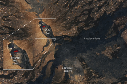
The Smoking Mountain
The heat is always on at Erta Ale volcano in Ethiopia. In East Africa’s Danakil (or Afar) Depression, three tectonic plates are pulling apart from each other, allowing magma to rise to the surface and feed several active volcanoes. Erta Ale is located in this rift zone and is Ethiopia’s most active volcano.
The volcano is known as the “smoking mountain” and the “gateway to hell” in the Afar language. A lava lake in its summit crater, shown in the inset (above), has roiled since at least 1967 and possibly since 1906. The image was acquired by the OLI (Operational Land Imager) on Landsat 8 on November 27, 2023, and includes an infrared signal (red) produced by the heat of molten rock.
In a recent spate of activity, satellites detected thermal anomalies in the summit crater starting in mid-September 2023. According to reports from the Global Volcanism Program, anomalies observed over the ensuing weeks likely corresponded to eruptions from spatter cones and small lava flows within the crater. Much of scientists’ understanding of Erta Ale’s volcanism comes from satellite observations since the area is remote and largely inaccessible for field study.
While activity is common at the summit, lava flows also occur on other parts of the mountain. Notably, from January 2017 to March 2020, fissure eruptions in the southeast caldera produced a large volume of basaltic lava that poured down the volcano’s flanks. The flows covered approximately 30 square kilometers (12 square miles), some of which is visible in this image extending to the northeast and southwest.
NASA Earth Observatory image by Lauren Dauphin, using Landsat data from the U.S. Geological Survey. Story by Lindsey Doermann.
0 notes
Text
Germany Military Lighting Market Research : Global Economy, By Penetration, Forecast, 2024-2032.

In the intricate landscape of defense operations, effective lighting solutions are essential for enhancing visibility, ensuring operational readiness, and safeguarding military personnel and equipment. The Germany Military Lighting Market stands as a pivotal segment within the global defense industry, offering a diverse range of lighting technologies and systems tailored to meet the unique needs and challenges faced by the nation's armed forces.
Several key factors contribute to the growth and prominence of the Germany Military Lighting Market. These include the nation's strong defense industrial base, advanced technological capabilities, and strategic investments in defense innovation. With a focus on excellence and reliability, Germany leads the way in developing cutting-edge lighting solutions to support the evolving requirements of defense operations.
Military lighting encompasses a wide range of applications, including tactical illumination, vehicle lighting, aircraft lighting, and base perimeter security, among others. These lighting systems are designed to provide reliable performance in diverse operational environments, from urban settings to remote battlefields, enabling military personnel to execute their missions with precision and effectiveness.
Moreover, the Germany Military Lighting Market places a strong emphasis on innovation, quality, and durability. Lighting technologies must withstand the rigors of military operations, including harsh environmental conditions, shock, and vibration, while delivering optimal performance and functionality. Additionally, integrated lighting solutions offer enhanced capabilities, such as night vision compatibility, thermal imaging, and remote control operation, to meet the evolving needs of defense missions.
Request Free Sample Report - Receive a free sample report to preview the valuable insights and data we offer.
Furthermore, advancements in lighting technologies, such as LED (Light-Emitting Diode) lighting, fiber optics, and smart lighting controls, have revolutionized defense illumination, providing improved visibility, reduced energy consumption, and enhanced situational awareness for military forces.
In conclusion, the Germany Military Lighting Market plays a crucial role in illuminating defense excellence. With a focus on innovation, reliability, and technological advancement, lighting manufacturers and suppliers in Germany ensure that military forces have access to cutting-edge lighting systems to meet the challenges of modern warfare, contributing to the continued strength and effectiveness of the nation's defense capabilities.
About US
At Market Research Future (MRFR), we enable our customers to unravel the complexity of various industries through our Cooked Research Report (CRR), Half-Cooked Research Reports (HCRR), Raw Research Reports (3R), Continuous-Feed Research (CFR), and Market Research & Consulting Services. MRFR team have supreme objective to provide the optimum quality market research and intelligence services to our clients. Our market research studies by products, services, technologies, applications, end users, and market players for global, regional, and country level market segments, enable our clients to see more, know more, and do more, which help to answer all their most important questions. To stay updated with technology and work process of the industry, MRFR often plans & conducts meet with the industry experts and industrial visits for its research analyst members.
Contact us:
Market Research Future (part of Wants tats Research and Media Private Limited),
99 Hudson Street,5Th Floor, New York, New York 10013, United States of America
Sales: +1 628 258 0071 (US) +44 2035 002 764 (UK)
Email: [email protected]
0 notes
Text
Emerging Trends in the Construction Industry in India

The construction industry is one of the foundations of a growing economy. Therefore, it is critical for a nation to invest in construction and infrastructure as it leads to a better environment where everyone can be more productive and valuable to society’s collective growth. Moreover, in today’s day and age, technology is driving change across all sectors of our economy with an aim to enhance productivity, optimization, and transparency. In this post, we examine the emerging trends in construction that are paving the way for a more efficient industry.
Automation and Drone Technologies: The key objective behind automation is to create technological interventions that reduce human effort and possibilities of human error as well as increase productivity. The domain is rapidly evolving in the construction sector through various solutions such as construction robotics that leverage robots to simplify manual processes, helping project managers achieve a quick turnaround time. Further, software applications also help automate several tasks, such as follow-up emails for vendors and clients, allowing you to focus on your core business. Another emerging trend in the construction sector today is the increased usage of drone technologies for various purposes. While conventional methods did the job, drones offer a much clearer view, helping project managers and end-customers access more accurate representations of construction projects. Drone technologies will help complete several activities like building surveys, construction site inspection, health and safety induction, maintenance inspection, project progress report, promotional photography, live feed and virtual walk walk-around logistics, and thermal imaging recordings.
Data Analytics: We live in a digital era that has led to a massive increase in information generated. Today, every business seeks to optimize the information it generates by leveraging data mining, processing, and analytics. Construction companies stand to benefit a lot by using data processing technologies as they will lead to actionable insights, leading to cost-effective and objective decision-making. This trend will undoubtedly enhance productivity, whether it is understanding the optimum utilization of materials or understanding demand trends.
Cloud-based BIM: Building Information Modeling (BIM) is becoming very popular, and its usage is gaining increasing prominence. Having cloud-based BIM software will help organizations access construction-related data much faster as opposed to on-premise installations. This optimizes the entire process and enables all stakeholders to access the relevant information in real-time.
Precast Technology: At Urbanaac, we foray into the world of faster, safer, and more robust construction by integrating precast technologies into construction methodologies. We bring together excellent craftsmanship, complete customization, and quality construction materials that are robust and also help reduce environmental and noise pollution. As a part of our solutions, we conceptualize, design, and execute customized construction elements, which helps project managers to achieve exceptional turnaround times while ensuring complete quality and safety!
Explore more about precast at https://urbanaac.com/
#precast #construction #building #india #gujarat
0 notes
Last Seen Blogs

wokegentlewoman
BlackKween

imwhitecat-blog
¿Suicid or Crazy?

littlecrazyhelmacron
Neep Neep!

garagebanners
Garage Banners Inc

8052117417-blog
Untitled