#jiigatake
Photo
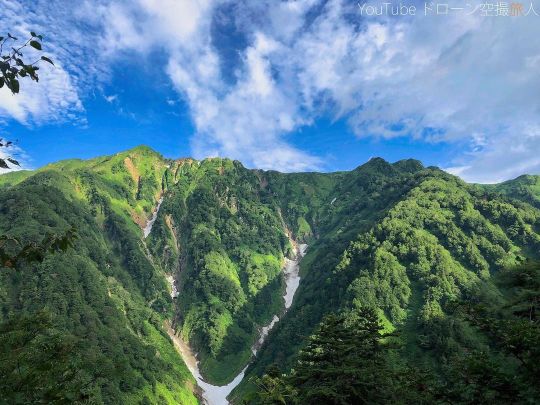
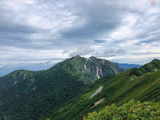
日本北アルプス縦走 鹿島槍ヶ岳・爺ヶ岳 iPhonexで撮影。どうしてもしんどい時はスマホになっちゃうんですよね。それでも色々修正かけてと。北アルプスは別次元で絶景ですな。山が綺麗だし、花も独特で凄いですね。朝日も拝めました。 Traversing the Northern Alps of Japan Mt. Kashima Yarigatake and Mt. Jiigatake Taken with iPhone x. When I'm sick, I'm going to be a smartphone. Still, I'm going to fix a lot of things. The Northern Alps is another dimension and a superb view. The mountains are beautiful and the flowers are unique and amazing. I also saw the sunrise. #絶景 #風景 #登山 #鹿島槍ヶ岳 #爺ヶ岳 #北ルプス #縦走 #北アルプス縦走 #絶景 #ドローン #空撮 #ドローン空撮 #japan #長野県 #climbing #kashimayarigatake #jiigatake #northernlupus #traversing #northernalpstraversing #superbview #drone #aerialphotography #droneaerialphotography #山好きな人と繋がりたい #yamap55 #山が好き #登山記me #ぼくらが山に登る理由 #山登り #mountaineering (鹿島槍ヶ岳) https://www.instagram.com/p/CixNHPavha-/?igshid=NGJjMDIxMWI=
#絶景#風景#登山#鹿島槍ヶ岳#爺ヶ岳#北ルプス#縦走#北アルプス縦走#ドローン#空撮#ドローン空撮#japan#長野県#climbing#kashimayarigatake#jiigatake#northernlupus#traversing#northernalpstraversing#superbview#drone#aerialphotography#droneaerialphotography#山好きな人と繋がりたい#yamap55#山が好き#登山記me#ぼくらが山に登る理由#山登り#mountaineering
0 notes
Photo
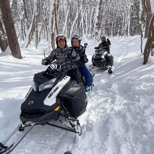
写真撮ってもらったので。 爺ヶ岳スキー場のスノーモービルサイドカントリーツアー。 詳しくはこちら https://jiigatake.com/adventure-world/ #爺ヶ岳スキー場 #jiigatake #jiigatakesnowmobile #snowmobiletours #スノーモービルツアー #スノーアクティビティー体験 #白銀の森クルーズ #長野県観光 #おおまち #家族旅行 #アウトドア #スノーアクティビティイベント (爺ガ岳スキー場) https://www.instagram.com/p/CJ4o-bIBL4P/?igshid=1jj0nbg5cl99q
#爺ヶ岳スキー場#jiigatake#jiigatakesnowmobile#snowmobiletours#スノーモービルツアー#スノーアクティビティー体験#白銀の森クルーズ#長野県観光#おおまち#家族旅行#アウトドア#スノーアクティビティイベント
0 notes
Link
O Indica Japão de hoje vai te apresentar um dos locais favoritos entre os turistas internacionais que é o vale de Hakuba compreende 10 diferentes estações de esqui. Rodeado por picos de 3.000 metros, Hakuba está localizado nos Alpes do Norte do Japão, 44 km a oeste de Nagano.
A área ganhou atenção internacional em 1998, quando sediou várias competições durante os Jogos Olímpicos de Inverno.
Com 137 km de pistas e mais de 200 percursos, os resorts de Hakuba oferecem uma variedade incrível com pistas adequadas para os praticantes de esqui de todos os níveis.
A vila principal, Happo, abriga alguns excelentes izakayas e restaurantes, também há locais mais tranquilas para quem quer ficar longe das multidões.
Localização: Hakuba, Distrito de Kitaazumi, Nagano, Japão
Conheça algumas estações principais de Hakuba
JIIGATAKE SNOW RESORT
A maioria das pistas de esqui é suave, com a pista principal oferecendo uma área ampla e deserta, com boa visibilidade. O Jiigatake Snow Resort é bom para as famílias desafiarem o esqui e o snowboard, bem como para iniciantes. No topo da montanha há trilhas para explorar, é calmo e tranquilo. Em um dia ensolarado, você pode apreciar a vista sobre Azumino. Toroika é um teleférico para crianças pequenas andarem com segurança e desfrutar de trenós.
Webesite www.jiigatake.com
KASHIMAYARI SNOW RESORT
O Kashimayari Snow Resort fica mais próximo da área de Matsumoto e Azumino, com 15 percursos diferentes para desafiar, sem mencionar a excelente vista dos Alpes do Norte. Do topo da montanha, você pode desfrutar de um percurso de 5.000m com excelente vista para o lago Aoki. O Central Plaza 1130 contem restaurantes, lojas, acomodações e uma vista deslumbrante para desfrutar do onsen ao ar livre depois do esqui.
Website www.kashimayari.net/snow
HAKUBA SONOSAKA SNOW RESORT
O Hakuba Sanosaka Snow Resort está cercado por belos bosques e uma cena do lago Aoki. 80% das pistas de esqui são para esquiadores e ciclistas iniciantes e intermediários. Este resort é mais popular entre famílias e esquiadores por lazer.
Webesite sanosaka.jp/
ABLE HAKUBA GORYO SNOW RESORT
O ABLE Hakuba Goryu Snow Resort tem 3 áreas de esqui alpino para desfrutar. Alpes-daira, Tohmi e Iimori. São 15 percursos em Goryu. A atratividade da pista de esqui Alpes-daira é a sazonalidade de longo prazo que está aberta até o final da Golden week. As qualidade de neve e vistas panorâmicas dos Alpes do Norte são características incríveis para desfrutar. A inclinação de Tohmi e de Iimori é ideal para novatos, intermediários e famílias. Ele também tem a maior área de esqui noturno.
Website hakubaescal.com/winter/
HAKUBA 47 WINTER SPORTS PARK
Em HAKUBA, o excelente parque de neve está no HAKUBA47 Winter Sports Park. Ele fornece um half-pipe para profissionais e um kicker para saltar, bem como uma variedade de itens no parque para jogar e desfrutar. Esquiar ou andar ou apenas sentar e assistir os outros esquiadores. Boa atmosfera e um ótimo lugar para fazer amigos. Do topo da montanha, também se pode acessar Hakuba Goryu, e ambos os resorts podem ser apreciados na passagem de montanha dupla
Website www.hakuba47.co.jp/winter/
HAKUBA HAPPO-ONE SNOW RESORT
Hakuba Happo-one Snow Resort é um magnífico local de esqui no Japão, amplamente reconhecido pelos Jogos Olímpicos de Inverno de Nagano, realizados em 1998. A vertical do Happo é uma das pistas mais íngremes de todo o Vale, com 1.071m. Um lugar para esculpir e rasgar algumas condições épicas de neve em pó para não mencionar as corridas mais longas que lhe permitem cruzar um percurso de 8000m. De iniciantes a nível avançado, desfrute das encostas de grande escala, mas você precisa de mais de um dia. A grande escala do Happo também oferece interessante mistura de restaurantes, cafés e paradas gastronômicas nas encostas e ao redor da base. Pode-se realmente desfrutar de deliciosa cozinha de Nagano.
Website www.happo-one.jp/
HAKUBA IWATAKE SNOW FIELD
O Campo de Hakuba Iwatake Snow Field expõe você a uma vista panorâmica de 360°C da cordilheira de Hakuba. Um elevador de gôndola irá levá-lo em uma viagem sem escalas até o topo da montanha. Aqui as pistas são largas e suaves, bem como um desafio proporcionando uma variedade de percursos para todos os níveis de esquiadores. Também é bem conhecido para trilhas de esqui cross-country que são constantemente mantidos durante todo o ano.
Website iwatake-mountain-resort.com/
TSUGAIKE KOGEN SNOW RESORT
Com um pano de fundo de 3.000 m de montanhas conhecidas como Os Alpes do Norte, este esplêndido cenário de montanha tem muita neve, neve pesada se acumula com freqüência e é a principal atratividade para os visitantes. Com uma largura de 1.200m é bem adequado para famílias e iniciantes. A gôndola é uma distância de 4.000m. O passeio em si é uma atividade turística. A zona de pó aqui é conhecida como “Tsuga-Pow DBD” também tem uma área para crianças.
Website www.tsugaike.gr.jp/
HAKUBA CORTINA SNOW RESORT
A neve pesada acumula frequentemente em Cortina, os registros anuais onde são mais elevados estão neste percursos da neve. Este fato, bem como esqui entre as árvore é incrível que torna um lugar muito popular para visitar. A atratividade não é apenas na estação de esqui, mas também o Hotel Green Plaza Hakuba com 257 quartos que é o maior nesta área, incluindo instalações onsen, uma variedade de refeições japonesas e italianas e, bem como fast food e um café com excelente menu de doces no total 5 restaurantes. Cortina é um local maravilhoso.
Website www.hgp.co.jp/cortina/
Em outra postagem voltarei com os valores e mais detalhes. Deixe comentário se você já visitou alguma dessas estações de esqui e o que acho.
Nos conte o que mais gostaria de saber.
Curta nossa fanpage para receber todas nossas novidades.
O post Conheça Hakuba, um dos melhores lugar para esquiar no Japão apareceu primeiro em Indica Japão.
0 notes
Text
My traverse of the Japanese Alps began at the eastern edge of Toyama Bay (富山湾) in Niigata Prefecture (新潟県). From the coast, my hiking party of two Kiwis and I headed up the northernmost ridgeline in the Kita Alps (北アルプス) – aka the Northern Alps. The trip began with nearly a week of nonstop rain as we traversed – it wasn’t until day four that we saw another person and it wasn’t until day five that we actually saw another hiker on the trail (the people we saw on day four were employees at a mountain hut we camped at).
The Northern Alps stretch from where we began, at the Tsugami Shindo Trailhead, to Ontakesan (御嶽山), or Mount Ontake, in the south. The Kita Alps are the longest of the three ranges comprising the Japanese Alps (the Kita (Northern), Chuo (Central), and Minami (Southern)) and this stretch took the first half of the hike – seventeen days (this includes a trip in and out of Toyama (富山市) via train from Tateyama (立山) for a resupply).
The photos in this post are in order of north to south and the peaks covered in this section are listed at the bottom of this post. If you’re interested in the daily itinerary for this route, you can find it here.
#gallery-0-5 { margin: auto; } #gallery-0-5 .gallery-item { float: left; margin-top: 10px; text-align: center; width: 33%; } #gallery-0-5 img { border: 2px solid #cfcfcf; } #gallery-0-5 .gallery-caption { margin-left: 0; } /* see gallery_shortcode() in wp-includes/media.php */
After three days of rain, we decided to hike out into the storm.
We didn’t see anyone for the first four days of hiking (not very popular up here).
There were a few minor traverses in the beginning where some spikes definitely would have helped.
A raicho (aka thunderbird) – one of the few animals we saw on the traverse.
One of the first good views we got on the entire hike (once the storm we began in finally broke).
Not all of the alps are green and lush.
These huts may be perched on ridgelines, but they are serious structures.
The late-afternoon clouds always did their best to greet us.
We were forced to pay to stay here (Kirettogoya) because the weather turned and there was literally nowhere for us to set up camp – the hut took the good spot.
Can you spot the hut?
Noodles – something you can find at most of the huts (sometimes hot water costs extra).
What your sleeping situation will look like should you decide to stay in a hut.
You’ll find these chains everywhere in the Kita Alps (I don’t trust them).
Honestly, I might end up doing something like this again.
Generally, the trails aren’t too overgrows, but we found a couple sections that were ungodly.
When I say that this entire hike is basically a ridgewalk, I’m not exaggerating.
Once you’re above the treeline, you don’t really go back down until you leave the mountains.
Testing out the Dyneema Djedi Dome from LOCUS GEAR.
In the case of a storm, you can’t just bail off the side – the mountains here are steep.
A rare boardwalked section of trail.
Heading down to Kurobe Lake from Harinokigoya was basically hiking down a river.
The only time we ever hiked along a river (I guess it’s hard when you’re ridgewalking most of the time).
Luckily, this river crossing on our way to Kurobe Lake wasn’t too flooded.
Crossing the bridge just before reaching the Kurobe Dam on the western side of the lake.
The Kurobe Dam – home to lots of tourists and, more importantly, food.
Tateyama is a huge tourist area and there are restaurants, lodges, stores, and this big stone sign.
Sunset at the Tateyama campground.
The largest snowfield we encountered – south of Tateyama.
Don’t forget, these mountains are filled with terribly annoying insects and the terrifying giant Japanese hornet.
For a not-that-wide island, there sure are a lot of mountains here.
If you see a peak in the distance, chances are you’re going over it.
Official campgrounds aren’t too common and the more accessible ones look like this.
Thomas, looking longingly at Yarigatake from the west – our goal for the day.
Walking the ridgeline to Yarigatake from Sugorokudake.
A look at how crowded the more popular peaks can get (we arrived here on a holiday – big mistake).
Looking back at Yarigatake from the south.
The ridges are endless.
The sun comes up early in the summer (like 5:00), and an early start is highly recommended. Just look at those faces.
This hut, just north of the Daikeretto (Big Cut) has camping (and noodles…and soda…).
A look at the Daikeretto (or “Big Cut” between Yarigatake and Kitahodaka.
The incredibly steep traverse from Okuhodaka to Nishihodaka.
Jandarumu (ジャンダルム) is one of the most awesome spots on the traverse.
One of my favorite bits of hiking in the world right here.
The front desk of a hut in the Kita Alps.
Climbing up to the summit of Yakedake from the north (can you see the hut in the valley on the right?).
The crater of Yakedake – an active volcano.
Walking the road after descending the southern side of Yakedake.
Approaching Norikuradake from the north (photo taken looking north).
These things drove me absolutely mad. Kill them.
One of the worst sections of trail we encountered – neading up the north side of Ontakesan.
The summit of Ontakesan – a volcano that erupted unexpectedly in 2014 and killed a bunch of hikers.
Kita Alps Peaks
Nyudoyama (入道山) – 1470 ft / 448 m
Shiritakayama (尻高山) – 2221 ft / 677 m
Sakatatoge (坂田峠) – 1903 ft / 580 m
Shiratoriyama (白鳥山) – 4222 ft / 1286.8 m
Shimokomagatake (下駒ヶ岳) – 4072 ft / 1241 m
Kikuishiyama (菊石山) – 3969 ft / 1209.7 m
Orenyama (黄蓮山) – 4462 ft / 1360 m
Inugatake (犬ヶ岳) – 5225 ft / 1592.5 m
Sawaganiyama (サワガニ山) – 5290 ft / 1612.3 m
Kuroiwayama (黒岩山) – 5327 ft / 1623.6 m
Nagatsugayama (長栂山) – 7438 ft / 2267 m
Asahidake (朝日岳) – 7047 ft / 2147.9 m
Yukikuradake (雪倉岳) – 8566 ft / 2610.9 m
Mikunisakai (三国境) – 9026 ft / 2751 m
Shiroumadake* (白馬岳) – 9620 ft / 2932.3 m
Maruyama (丸山) – 9081 ft / 2768 m
Shakushidake (杓子岳) – 9226 ft / 2812 m
Yarigatake (鑓ヶ岳) – 9525 ft / 2903.2 m
Tengu Peak (天狗の頭) – 9226 ft / 2812.1 m
Karamatsudake (唐松岳) – 8845 ft / 2695.9 m
Daikokudake (大黒岳) – 7851 ft / 2393 m
Shiradake (白岳) – 8337 ft / 2541 m
Goryudake* (五龍岳) – 9232 ft / 2814 m
Kashimayarigatake (North) (鹿島槍ヶ岳北峰) – 9324 ft / 2842 m
Kashimayarigatake* (鹿島槍ヶ岳) – 9479 ft / 2889.2 m
Nunobikiyama (布引山) – 8802 ft / 2683 m
Jiigatake (North) (爺ヶ岳北峰) – 8632 ft / 2631 m
Jiigatake (爺ヶ岳) – 8760 ft / 2669.9 m
Jiigatake (South Peak) (爺ヶ岳南峰) – 8727 ft / 2660 m
Iwagoyazawadake (岩小屋沢岳) – 8630 ft / 2630.5 m
Shinkoshinokkoshi (新越乗越) – 8077 ft / 2462 m
Narusawadake (鳴沢岳) – 8665 ft / 2641 m
Akazawadake (赤沢岳) – 8786 ft / 2678 m
Subaridake (スバリ岳) – 9029 ft / 2752 m
Harinokidake (針ノ木岳) – 9254 ft / 2820.7 m
Harinokitoge (針ノ木峠) – 8320 ft / 2536 m
Tateyama (Oyama)* (立山(雄山)) – 9852 ft / 3003 m
Ryuodake (龍王岳) – 9423 ft / 2872 m
Onidake (鬼岳) – 9022 ft / 2750 m
Shishidake (獅子岳) – 8904 ft / 2714 m
Zaratoge (ザラ峠) – 7703 ft / 2348 m
Tonbiyama (鳶山) – 8583 ft / 2616 m
Echuzawadake (越中沢岳) – 8503 ft / 2591.6 m
Sugonoatama(?) (スゴの頭) – 7976 ft / 2431 m
Mayama (間山) – 8482 ft / 2585.4 m
Yakushidake (North) (北薬師岳) – 9514 ft / 2900 m
Yakushidake* (薬師岳) – 9600 ft / 2926 m
Yakushitoge (薬師峠) – 7526 ft / 2294 m
Taroyama (太郎山) – 7785 ft / 2373 m
Kitanomatadake (北ノ俣岳) – 8733 ft / 2661.9 m
Akagidake (赤木岳) – 8602 ft / 2622 m
Nakamatanokkoshi (中俣乗越) – 8038 ft / 2450 m
Kurobegorodake* (黒部五郎岳) – 9645 ft / 2939.7 m
Mitsumatarengedake (三俣蓮華岳) – 9322 ft / 2841.4 m
Maruyama (丸山) – 9364 ft / 2854 m
Sugorokudake (双六岳) – 9385 ft / 2860.4 m
Momisawadake (樅沢岳) – 9039 ft / 2755 m
Ionokkoshi (硫黄乗越) – 8399 ft / 2560 m
Senjo Junction (千丈乗越) – 8957 ft / 2730 m
Yarigatake* (槍ヶ岳) – 10433 ft / 3180 m
Hidanokkoshi (飛騨乗越) – 10105 ft / 3080 m
Obamidake (大喰岳) – 10180 ft / 3103 m
Nakadake (中岳) – 10118 ft / 3084 m
Minamidake (南岳) – 9950 ft / 3032.9 m
Daikeretto (大キレット) – 9016 ft / 2748 m
Kita-Hotakadake (北穂高岳) – 10190 ft / 3106 m
Karasawadake (涸沢岳) – 10203 ft / 3110 m
Oku-Hotakadake* (穂高岳) – 10466 ft / 3190 m
Gendarme (ジャンダルム) – 10377 ft / 3163 m
Tengunoatama (天狗ノ頭) – 9544 ft / 2909 m
Ainodake (間ノ岳) – 9537 ft / 2907 m
Nishihotakadake (西穂高岳) – 9543 ft / 2908.8 m
Nishihodoppyo (西穂高岳 独標) – 8862 ft / 2701 m
Nishiomaruyama (西穂 山荘) – 8045 ft / 2452 m
Waritaniyama (割谷山) – 7297 ft / 2224.2 m
Shinnakaotoge (新中尾峠) – 7021 ft / 2140 m
Nakatoge (中尾峠) – 7021 ft / 2140 m
Yakedake* (焼岳) – 8056 ft / 2455.5 m
Iodake (硫黄岳) – 8379 ft / 2554 m
Daikokudake (大黒岳) – 9094 ft / 2772 m
Fujimidake (富士見岳) – 9242 ft / 2817 m
Kodamadake (蚕玉岳) – 9760 ft / 2975 m
Kengamine (剣ヶ峰) – 9927 ft / 3025.7 m
Mamakodake (継子岳) – 9380 ft / 2859.1 m
Hidachojo (御嶽四の池) – 9226 ft / 2812 m
Peaks denoted with an asterisk (*) are part of Nihon Hyakumeizan (100 Famous Japanese Mountains).
Japan Traverse in Photos: The Kita Alps (北アルプス) My traverse of the Japanese Alps began at the eastern edge of Toyama Bay (富山湾) in Niigata Prefecture (新潟県).
0 notes
Photo
【絶景登山】鹿島槍ヶ岳・爺ヶ岳 北アルプス縦走 テント泊でドローン空撮 鹿島槍ヶ岳・爺ヶ岳の北アルプス縦走登山へ行ってきました。場所は長野県大町市平です。もう凄い絶景でしたよ。ドローン空撮も少しですが撮影してきました。ただね距離長い・・めちゃくちゃ長い。そしていつものみんなに抜かれていくというかなりの遅さ。しかも数人で行ったのですが、遅れる遅れる。ただりょーじさんが言ってた意外と努力でなんとかなると言ってたので頑張り、かなり遅れましたがなんとか無事に終了しました。雷鳥なんですがたぶんね、爺ヶ岳と冷池山荘の間にいてましたよ。あ、あと爺ヶ岳付近の動画はきたないので、飛ばしてくれてもかまいまへん。そして遅れた分いろんな場所で絶景を撮影できたので是非見て下さい。チャンネル登録も忘れずにね^^ 【絶景登山】鹿島槍ヶ岳・爺ヶ岳 北アルプス縦走 テント泊でドローン空撮動画はこちら [Superb mountaineering] Mt. Kashima Yari-gatake and Mt. Ji-gatake Northern Alps traverse Click here for drone aerial video with tent stay https://youtu.be/Yrl8je4b3pw [Superb mountaineering] Mt. Kashima Yarigatake/Mt. I went to the Northern Alps traverse climbing Mt. Kashima Yari-gatake and Mt. The location is Taira, Omachi City, Nagano Prefecture. It was already a great view. I also took a few drone aerial shots. It's just that the distance is long... it's really long. And it's quite slow to be overtaken by everyone. Moreover, I went with several people, but I will be late. However, Ryoji-san said that surprisingly hard work would work, so I did my best. It's a thunderbird, but it was probably between Mt. Jiigatake and Reiike Sanso. Oh, and the video around Mt. Jiigatake is messy, so feel free to skip it. And because I was late, I was able to shoot superb views in various places, so please take a look. Don't forget to subscribe to the channel ^^ #登山 #鹿島槍ヶ岳 #爺ヶ岳 #北ルプス #縦走 #北アルプス縦走 #絶景 #ドローン #空撮 #ドローン空撮 #climbing #kashimayarigatake #jiigatake #northernlupus #traversing #northernalpstraversing #superbview #drone #aerialphotography #droneaerialphotography #山好きな人と繋がりたい #yamap55 #山が好き #登山記me #ぼくらが山に登る理由 #山登り #mountaineering #japanesenature #mountainlovers #mountainlife ドローン空撮旅人のお問い合わせのメールアドレス [email protected] 【絶景登山】鹿島槍ヶ岳・爺ヶ岳 北アルプス縦走 テント泊でドローン空撮 ヤマップ yamap.com/users/2025596 登山 登山ギア 絶景 癒し ハイキング 登山用品 キャンプ キャンプギア キャンプ道具 【絶景登山】鹿島槍ヶ岳・爺ヶ岳 北アルプス縦走 テント泊でドローン空撮 https://www.instagram.com/p/CiodVKNv7BX/?igshid=NGJjMDIxMWI=
#登山#鹿島槍ヶ岳#爺ヶ岳#北ルプス#縦走#北アルプス縦走#絶景#ドローン#空撮#ドローン空撮#climbing#kashimayarigatake#jiigatake#northernlupus#traversing#northernalpstraversing#superbview#drone#aerialphotography#droneaerialphotography#山好きな人と繋がりたい#yamap55#山が好き#登山記me#ぼくらが山に登る理由#山登り#mountaineering#japanesenature#mountainlovers#mountainlife
0 notes
Video
youtube
【絶景登山】鹿島槍ヶ岳・爺ヶ岳 北アルプス縦走 テント泊でドローン空撮
https://youtu.be/Yrl8je4b3pw
#youtube#climbing kashimayarigatake jiigatake northern lupus traversing northern alps traversing superb view drone aerial photography drone aerial ph
0 notes
Photo
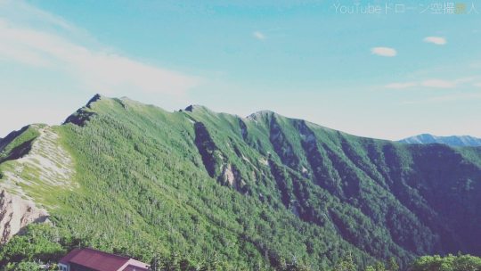
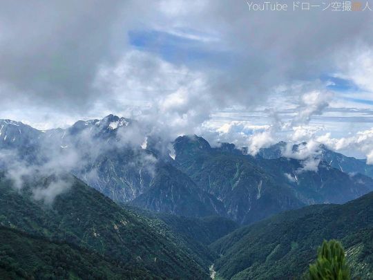
絶景ドローン空撮の鹿島槍ヶ岳/爺ヶ岳登山 北アルプス縦走| ドローン空撮動画の切り抜きなので解像度は低いですが、やはり一場面を見てもかっこいいですね。1枚目は爺ヶ岳とよーく見て下さい、種池山荘がありますよ。爺ヶ岳南峰の私。風景がほぼほぼ白w Scenic drone aerial photography of Mt. Kashima Yarigatake/Mt. The resolution is low because it is a clipping of the drone aerial video, but it is still cool to see one scene. Take a close look at Mt. Jiigatake on the first one, there is Taneike Sanso. Me at the south peak of Mt. The scenery is almost white (laughs) #ドローン #空撮 #ドローン空撮 #ドローン撮影 #雲 #空 #風景 #自然 #綺麗 #絶景 #mountain #mountains #mountainneer #mountainlife #mountainporn #mountainside #mountainlove #mountainesia #mountaingram #sky #japan #ig_japan #lover_nippon #登山 #鹿島槍ヶ岳 #爺ヶ岳 #百名山 #北アルプス #長野県 #テント泊 https://www.instagram.com/p/CjFDgt9Pei_/?igshid=NGJjMDIxMWI=
#ドローン#空撮#ドローン空撮#ドローン撮影#雲#空#風景#自然#綺麗#絶景#mountain#mountains#mountainneer#mountainlife#mountainporn#mountainside#mountainlove#mountainesia#mountaingram#sky#japan#ig_japan#lover_nippon#登山#鹿島槍ヶ岳#爺ヶ岳#百名山#北アルプス#長野県#テント泊
2 notes
·
View notes
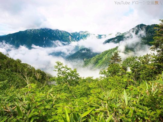
Photo
北アルプス縦走 鹿島槍ヶ岳・爺ヶ岳テント泊登山 下山の最後辺りに撮影した写真。だいぶ綺麗に撮れましたね。爺ヶ岳横辺りが綺麗でした。また雲が下に合って円盤みたいなカタチになってましたね。鹿島槍ヶ岳は綺麗に撮れました^^ iPhonexで撮影。 Traversing the Northern Alps Mt. Kashima Yarigatake/Mt. This photo was taken near the end of the descent. It was a beautiful shot, wasn't it? The area around Mt. Jiigatake was beautiful. Also, the clouds meet below and form a disk-like shape. Kashima Yarigatake was taken beautifully ^ ^ Taken with iPhone x. #絶景 #風景 #登山 #鹿島槍ヶ岳 #爺ヶ岳 #北ルプス #縦走 #北アルプス縦走 #絶景 #テント泊 #ハイキング #トレッキング #長野県#山好きな人と繋がりたい #yamap55 #山が好き #登山記me #ぼくらが山に登る理由 #山登り #japan #climbing #kashimayarigatake #jiigatake #northernlupus #traversing #northernalpstraversing #superbview #drone #aerialphotography #droneaerialphotography (鹿島槍ヶ岳) https://www.instagram.com/p/Ci2A_GTvtVX/?igshid=NGJjMDIxMWI=
#絶景#風景#登山#鹿島槍ヶ岳#爺ヶ岳#北ルプス#縦走#北アルプス縦走#テント泊#ハイキング#トレッキング#長野県#山好きな人と繋がりたい#yamap55#山が好き#登山記me#ぼくらが山に登る理由#山登り#japan#climbing#kashimayarigatake#jiigatake#northernlupus#traversing#northernalpstraversing#superbview#drone#aerialphotography#droneaerialphotography
0 notes
Photo
北アルプス縦走 鹿島槍ヶ岳・爺ヶ岳テント泊登山 雲が演出してくれました。深夜の鹿島槍ヶ岳、今見たら怖いですねw冷池山荘の朝日、種池山荘と山。iPiPhonexで撮影02。 Traversing the Northern Alps of Japan Mt. Kashima Yarigatake and Mt. Jiigatake Played by the clouds. Kashima Yarigatake in the middle of the night, it's scary to see it now. Taken with iPiPhonex02. #絶景 #風景 #登山 #鹿島槍ヶ岳 #爺ヶ岳 #北ルプス #縦走 #北アルプス縦走 #絶景 #テント泊 #ハイキング #トレッキング #長野県#山好きな人と繋がりたい #yamap55 #山が好き #登山記me #ぼくらが山に登る理由 #山登り #japan #climbing #kashimayarigatake #jiigatake #northernlupus #traversing #northernalpstraversing #superbview #drone #aerialphotography #droneaerialphotography (鹿島槍ヶ岳) https://www.instagram.com/p/Ciygs1sPwJj/?igshid=NGJjMDIxMWI=
#絶景#風景#登山#鹿島槍ヶ岳#爺ヶ岳#北ルプス#縦走#北アルプス縦走#テント泊#ハイキング#トレッキング#長野県#山好きな人と繋がりたい#yamap55#山が好き#登山記me#ぼくらが山に登る理由#山登り#japan#climbing#kashimayarigatake#jiigatake#northernlupus#traversing#northernalpstraversing#superbview#drone#aerialphotography#droneaerialphotography
0 notes
Photo
最近ユーチューブばっかりすみませんでした。久しぶりにインスタグラムに合う投稿♪ 爺ヶ岳・鹿島槍ヶ岳絶景登山 北アルプスの百名山のひとつ鹿島槍ヶ岳(と爺ヶ岳)に行ってきました。いやもう景色が凄すぎ!絶景でした。所々に花も咲いており、そんな花は知らないんですがこれまた変わったいろんな花があり私でも興味引きますね^^また後日しっかり編集して写真及び動画も出していきますので宜しくっす! ちなみに写真はまだ3合目ぐらいかな。それでも綺麗(^^♪ Mt. Jiigatake and Mt. Kashimayarigatake Scenic Mountain Climbing I went to Mt. Kashima Yarigatake (and Mt. Jiigatake), one of the 100 famous mountains in the Northern Alps. No, the scenery is too amazing! It was a superb view. Flowers are blooming here and there. ! By the way, I wonder if the picture is still about the 3th. Still beautiful (^^♪ #爺ヶ岳 #鹿島槍ヶ岳 #絶景 #登山 #綺麗 #おすすめ #ハイキング #北アルプス #アルプス #長野県 #百名山ハンター #百名山チャレンジ #日本百名山ひと筆書き #日本百名山チャレンジ #日本百名山 #百名山 #百名山を制覇したい #百名山山頂 #山好きな人と繋がりたい #yamap55 #山が好き #登山記me #ぼくらが山に登る理由 #山登り #ハイキング #登山ファッション #ソロ登山 #mountaineering #japanesenature #mountainlovers (鹿島槍ヶ岳) https://www.instagram.com/p/ChPZAtoPmXw/?igshid=NGJjMDIxMWI=
#爺ヶ岳#鹿島槍ヶ岳#絶景#登山#綺麗#おすすめ#ハイキング#北アルプス#アルプス#長野県#百名山ハンター#百名山チャレンジ#日本百名山ひと筆書き#日本百名山チャレンジ#日本百名山#百名山#百名山を制覇したい#百名山山頂#山好きな人と繋がりたい#yamap55#山が好き#登山記me#ぼくらが山に登る理由#山登り#登山ファッション#ソロ登山#mountaineering#japanesenature#mountainlovers
0 notes
Photo
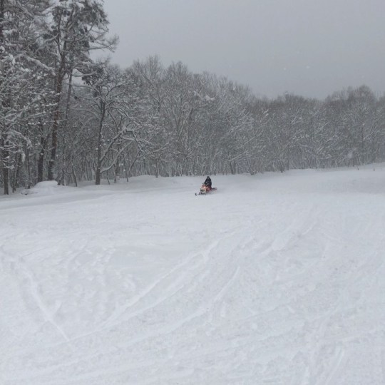
今日の爺ヶ岳の目的はこれ! スノーモービル体験! @outdoor_guides_kiboco の尾崎さんがやると聞いて楽しみにしてたら、1/1-3緊急告知で体験が出来ると知って早速タンデムに乗せてもらいましたー 黒いのが体験用モービルだけど、赤いのにも乗せてもらって、ドドンパ体験! これ、ほんとメチャクチャ楽しいので、正式サービスインしたら、是非皆さん、お試しあれ! ホームページにも載ってますが、この三ヶ日は10:00.-14:30、5分、¥500で、出来ますよ。 スノーモービルも楽しめて、ゲレンデも広いし、今年は良いコンディジョンなので、爺ヶ岳スキー場は、超一推しです! そして帰りはやっぱり薬師の湯温泉に。 #jiigatakehappysnowpark #jiigatake #爺ヶ岳 #爺ヶ岳スキー場 #爺ヶ岳スノーモービル #jigatakesnowmobile #jiigatakesnowmobile #snowmobile (爺ガ岳スキー場) https://www.instagram.com/p/CJfq7e4hgNA/?igshid=1guq9wcf6pkao
#jiigatakehappysnowpark#jiigatake#爺ヶ岳#爺ヶ岳スキー場#爺ヶ岳スノーモービル#jigatakesnowmobile#jiigatakesnowmobile#snowmobile
0 notes
Last Seen Blogs

lilahlavender
Lilah Lavender

bellesandbeaus1
Style Service and Fun

damiansgoodgirll
wwe and football enthusiastic

newyorkattorney
Wiesner Law Firm

pretty-pretty-princess-posts
Princess