#google mymaps
Text
Fallout Real Life Map (Maps) (Real Filming Locations)
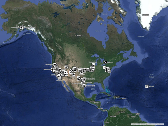
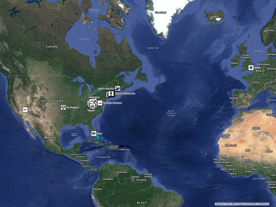
Maps by @warrenwoodhouse. A complete set of maps that feature all of the real life locations from the entire @fallout franchise. Map 1 includes all of the locations from Fallout to Fallout: New Vegas. Map 2 includes all of the locations from Fallout 4 to present. Map 2 also includes the officially recognised mods locations, which are Fallout 4: Vault 1080, Fallout 4: Fallout 3: The Capitol Wasteland, Fallout 4: Fallout London, Fallout 4: Fallout: New Vegas and Fallout 4: Fallout Miami. I’ve also included the locations from the newly created Amazon Prime Original Series. Vaults Map includes all of the Vaults in one map, so that you can find them easily. Mods Map includes all of the locations from all of the officially recognised mods and all of the locations from all of the unofficial mods as well. When sharing or reblogging this post, please include the hashtag #warrenwoodhouse in the tags section.
All Locations Map: https://www.google.com/maps/d/u/0/viewer?mid=1lfvecCrK4XvprlXwHPpkFa9EZ-lOA0g
Map 1: https://www.google.com/maps/d/u/0/viewer?mid=1mgfJ-78PmsuP6_5yvRm0fIPx53Y
Map 2: https://www.google.com/maps/d/u/0/viewer?mid=1YxEfL8jq9VJ_2u7yPqxzbKfq0nhzTNyD
Map Vaults: https://www.google.com/maps/d/u/0/viewer?mid=1YmfLtMuEnBWYjUOGxelFUrHcwcUGn_CK
Map 3: To be announced
Below is information such as what tools I used to create additional map icons, changelog, references and more.
Tools I’ve Used
Adobe Express: Some of the icons in the maps were created originally by me using @adobe #AdobeCreativeCloud #AdobeExpress, these icons are available for other uses by request via my Ask page. CLICK HERE to use the Ask page. CLICK HERE to use Adobe Express.
FANDOM: The original map icons that appeared in the in-game maps were taken from the official Nukapedia Wiki, also known as Fallout Wiki. CLICK HERE to visit the official Fallout Wiki on FANDOM.
Google My Maps: Let’s you create real world maps filled with places. If you’ve starred a place on Google Maps, this will appear in your own private Favourites map on Google My Maps. CLICK HERE to create a map.
What Links Here
UI Map Icons Category - Categories - Fallout Wiki on FANDOM (Category)
Google My Maps - Google Maps - Google (App)
Adobe Express - Products - Adobe (App)
Fallout (franchise) - Franchises - Microsoft Bethesda Softworks - Microsoft Game Studios - Microsoft (Franchise)
Changelog
29th April 2024 at 10:18 am: Created the full Fallout franchise map as one whole map! I’m currently importing locations from my other maps. You’ll still be able to access the other maps afterwards as well. This map will feature every single location from the entire franchise
15th April 2024 at 3:00 pm: Created the Vaults map
15th April 2024 at 6:00 am: Updated the post with new sections
13th April 2024 at 7:00 pm: Added a new section titled “Fallout (TV Series) (Amazon Prime Original Series)” to the map and added Vault 33 to the map. More coming soon, my fellow Vault Dwellers
16th February 2024 at 6:20 am: Updated map description
4th July 2021 at 4:30 pm: Added columns to the locations database on my wiki for the section titled “Fallout 4”
3rd July 2021 at 4:30 pm: Added “Fallout 3” locations to the map. Added “Fallout 3: Broken Steel” locations to the map
29th June 2021 at 5:55 pm: Added “Fallout 4” locations to the map. Updated map description. Added my screenshots into the “Fallout 4” section on the map. Added the section titled “Fallout 5 (TBA)” to the map. Added “Fallout 3” locations to the map
28th June 2021 at 6:22 pm: Added “Fallout 3” locations to the map. Updated section title for the section titled “Fallout, Fallout 2” & I’ve updated section title for the section titled “Fallout (Film)”
25th June 2021 at 3:20 pm: Added “Fallout 3” locations to the map, added “Fallout 3: Operation: Anchorage” locations to the map and I’ve also added the “Fallout 3: Morhership Zeta” locations to the map
14th June 2021 at 8:09 am: Updated map description
12th June 2021 at 11:15 am: Updated the section title for “Fallout 4” which now lists all of its DLCs and official Mods. Updated the section title for “Fallout 76” which now lists all of its DLCs. Added “Fallout 3: The Pitt” locations to the map and I’ve also added “Fallout 3: Point Lookout” locations to the map
11th June 2021 at 10:00 am: Added my screenshots into the “Fallout 4” section on the map
10th June 2021 at 4:44 pm: Added “Fallout 3: The Pitt” locations to the map, updated the map description & added “Fallout 3: Point Lookout” locations to the map
21st July 2020 at 2:21 pm: Updated map description and added screenshots to various locations on both maps
28th December 2019 at 10:00 am: Map 1 almost fully up to date so I created a second map (Map 1 for everything from the original series & Map 2 for Fallout 4 to present)
14th August 2018 at 1:00 pm: Copied map from the original Google My Maps map created by another Fallout fan & I’ve added more locations to the map from “Fallout”, “Fallout 2”, “Fallout Tactics”, “Fallout Tactics: Brotherhood of Steel”, “Fallout: Van Buren (Cancelled)”, “Fallout 3”, “Fallout: New Vegas” and “Fallout (Film) (Cancelled)”
#warrenwoodhouse#gaming#maps#google maps#googlemaps#google mymaps#map#.map#fallout#fallout 3#fallout: new vegas#fallout new vegas#fallout3#falloutnewvegas#fallout 4#fallout4#fo4#fo3#fonv#real filming locations#realfilminglocations#real life#xboxshare#xbox share#Microsoft fallout#Microsoft Bethesda fallout#Microsoft Xbox fallout#Xbox fallout#Bethesda fallout
22 notes
·
View notes
Text
Name: Advogado Trabalhista - Daniel Bruel
Adress: Av. Anita Garibaldi, 2047 - Ahú, Curitiba - PR, 82200-530
Phone: (41) 99685-5163
E-mail:[email protected]
Website: https://www.canva.com/design/DAFx7v9dGZg/6I7bhETKZdDO-NkWgVu6FA/view?utm_content=DAFx7v9dGZg
Pagina Institucional: https://advdanielbruel.com.br/
FICHA GOOGLE EMPRESA: https://www.google.com/maps?cid=8836721220411439702
WEEBLY: https://advdanielbruel.weebly.com/
MYMAPS: https://www.google.com/maps/d/edit?mid=1R-7UvhIpEfEH9ft7jH1ajnAMwu62c4I&ll=-25.38986544787402%2C-49.26606064197707&z=15
-25.39457, -49.25838
LINKS
https://www.youtube.com/@advdanielbruelhttps://advdanielbruel.com.br/blog/https://www.instagram.com/advdanielbruel/https://www.linkedin.com/in/advdanielbruel/https://www.facebook.com/advdanielbruelhttps://advdanielbruel.com.br/
2 notes
·
View notes
Text
MyMaps Experience
This week I worked with MyMaps, a GoogleMaps based application that allows me to save/explore certain areas relevant to my studies. I worked alongside this tutorial for ease of learning and to speed things along so I didn’t have to go back and forth between the video and the test map. This map was centered around the main islands Hawaiian Archipelago (Hawai’i, Maui, Moloka’i, O'ahu, and Kaua’i) and focused on things like sustainable agriculture, ecotourism destinations, and nature preserves. For the purpose of this assignment, I chose one area of each category to showcase:
Sustainable Agriculture: Kualoa Ranch (Spoon and Fork Icon)
Ecotourism: Waimea Canyon State Park (Hiking Icon)
Nature Preserves: Volcanoes National Park (Volcano Icon)

The user interface of My Maps is very friendly and simple. You won’t need any fancy coding or GIS skills to use it, which offers non-academic opportunities to people like writers who want to save certain locations for worldbuilding or reference purposes (which I certainly plan to do in the future). Back to the biodiversity side of things, MyMaps enables you to mark areas that are important to biodiversity for a myriad of reasons, whether that be preservation or education to the general public about biodiversity. Kualoa Ranch is an example of education, as it offers behind-the-scenes tours of how they grow their food in accordance with the ancient sustainable practices of the native Hawaiians. Volcanoes NP is a good example of preservation, as the park operates in accordance with the National Parks mission to “preserve unimpaired the natural and cultural resources and values of the national park system for the enjoyment, education, and inspiration of this and future generations” (About the National Park Service 2016).
When it comes to the individual locations selected, there are quite a few customization options available. You can select different icons (as mentioned above), but you can also color code them for things like different projects. I didn't do that for this assignment, but when I use this in the future for non-academic endeavors I can color code based on stories. Each location you pick has the option of adding images to the Infocard (shown below with Volcanoes NP). Once again, this has both biodiversity and writerly applications.

When you zoom in on one particular area, you can outline the area with MyMaps. While I didn’t use this application, there is a way to import a data table into My Maps to get a more accurate outline of a desired location. This can be used for mapping vulnerable areas that are key to protecting biodiversity, such as Hanauma Bay (not shown on map) which serves as an important reserve for different species of fish and corals.
For finishing it all off, there are numerous options on the main card of the map. One of the most useful that I found was the “set to default view”. This enables me to preset where I want the map to open whenever I click on the Hawaiian Archipelago project, which saves me a lot of scrolling and dragging. Although I didn’t use any of the embedding options, it should be noted that much like a google doc or drive file, you have to enable sharing permissions in order to share it with others.

That's all for this week! Happy mapping!
Sources:
“About the National Park Service”. March 30, 2016. https://www.nps.gov/aboutus/aboutus.htm#:~:text=The%20mission%20of%20the%20National,of%20this%20and%20future%20generations.
#grad school#grad student#grad studyblr#biodiversity#hawaii#hawaiian islands#mapping applicatoins#MyMaps#worldbuilding
2 notes
·
View notes
Text

MyMaps, Clases N°8-N°11. Historia de la Arquitectura II.
4 notes
·
View notes
Text
2S Digital | Agência de Marketing Digital | Especialista em Google
A 2S Digital, é agência de marketing digital, líder em impulsionar negócios locais com expertise em SEO, mídias sociais e conteúdo estratégico. Comprometida com o sucesso de seus clientes, oferece análises precisas e estratégias inovadoras para otimizar a visibilidade e crescimento. A agência compreende necessidades locais e objetivos digitais, garantindo estar sempre à frente da concorrência.
Endereço: R. José Roncoleta, 245 - Centro, Salto - SP, 13320-080
Telefone: (11) 98024-0375
e-mail: [email protected]
Site: https://2sdigital.com.br
Perfil Google: https://maps.app.goo.gl/sgxfzUo9XRTb9EpN8
MyMaps:
https://www.google.com/maps/d/edit?mid=14QRBeqsXf7CX2D3lmMbY9WUXc7iAcR4&usp=sharing
#2S Digital | Agência de Marketing Digital | Especialista em Google
0 notes
Text
Big Dawg Dumpsters Prices
Tucked away in Charlotte County, Florida, is the unincorporated area of Port Charlotte, a vibrant and census-designated place renowned for its historic charm, natural allure, and hospitable environment. This recognition includes being named one of the “10 Best Places to Retire” in the United States by U.S. News & World Report in 2012.
The history of Port Charlotte dates back about 10,000 years to the Paleo-Indians, nomads who traversed the region during the last ice age, hunting large animals like woolly mammoths. Initially, Port Charlotte was not on the coast, as Florida's peninsula was much broader and drier.
With the end of the ice age, sea levels rose, shaping Florida’s present geography and climate. The Paleo-Indians were succeeded by the Calusa, the “shell people,” a thriving culture along the southwest Florida coast until the first Spanish explorers arrived in the 16th century. European contact led to the decline of the Calusa due to diseases like smallpox and measles, eventually making way for the Seminole people.
Florida transformed from a Spanish territory in 1819 to a U.S. state in 1845. Despite this, the Port Charlotte area remained largely underdeveloped for a century, mostly bypassing major transport routes and inhabited by a few cattle ranches and farms.
The post-World War II era marked a turning point, with the General Development Corporation, led by the Mackle brothers, capitalizing on the Florida land boom in the 1950s to develop areas including Port Charlotte. Despite significant growth, Port Charlotte retained its unincorporated status.
The community's resilience was tested by two major hurricanes. In 2004, Hurricane Charley, a Category 4 storm, struck near Charlotte Harbor, causing extensive damage. In 2022, Hurricane Ian, another Category 4 hurricane, inflicted significant destruction in the area.
Geographically, Port Charlotte’s location adds to its charm. Positioned at the north end of the Charlotte Harbor Estuary and close to Punta Gorda, it’s conveniently located between Tampa and Naples. Covering over 32 square miles, the area enjoys a warm, humid subtropical climate with hot summers and mild winters, contributing to an appealing temperature range year-round.
Port Charlotte represents more than a geographic location; it embodies a community enriched with historical depth, resilient spirit, and natural beauty. Its journey from ancient times to contemporary resilience highlights its status as an attractive and welcoming destination for both residents and retirees seeking the best of Florida living.
youtube
Featured Business:
Big Dawg Dumpsters LLC specializes in efficient waste management, allowing you to focus on your primary tasks. Our strong commitment to the quality and resilience of our dumpsters in Port Charlotte guarantees not just savings in time and effort but also provides a crucial tool for facilitating your garage cleanouts or managing major decluttering endeavors.
Contact:
Big Dawg Dumpsters LLC
17098 Marydale Rd, Port Charlotte, FL 33948, United States
XR8J+F3 Port Charlotte, Florida, USA
(743) 244–3294
26.93811040, -82.17401880
https://bigdawgfl.com/
Youtube Video:
https://www.youtube.com/watch?v=99xaizrDTx0
Youtube Playlist:
https://www.youtube.com/playlist?list=PLFLCke3VfXvPFpO7oHrQw1dlCEUTBntnh
Soundcloud:
https://soundcloud.com/big-dawg-dumpsters-llc/big-dawg-dumpsters-prices
Soundcloud Playlist:
https://soundcloud.com/big-dawg-dumpsters-llc/sets/big-dawg-dumpsters-prices
Medium Post:
https://medium.com/@bigdawgdumpstersllc/big-dawg-dumpsters-prices-1bfdaeb2473b
Weebly:
https://bigdawgdumpstersprices.weebly.com/
Tumblr:
https://bigdawgdumpsters.tumblr.com/post/737048372319551488/big-dawg-dumpsters-prices
Google MyMaps:
https://www.google.com/maps/d/viewer?mid=1ONoYwxxxcPKSP6c81TRpbDC-oC6GkHA
Google Maps CID:
https://www.google.com/maps?cid=17234576815232776912
Google Site:
https://sites.google.com/view/big-dawg-dumpsters-prices/
Twitter List:
https://twitter.com/i/lists/1736711169476526113
Twitter Tweets:
https://x.com/BigDawgDumpLLC/status/1736724006332760449
https://x.com/BigDawgDumpLLC/status/1736724467890761828
https://x.com/BigDawgDumpLLC/status/1736724618701046120
https://x.com/BigDawgDumpLLC/status/1736724764209942628
https://x.com/BigDawgDumpLLC/status/1736724174620795093
https://x.com/BigDawgDumpLLC/status/1736724966681547100
https://x.com/BigDawgDumpLLC/status/1736725106502828145
https://x.com/BigDawgDumpLLC/status/1736724329893957761
https://x.com/BigDawgDumpLLC/status/1736725247481843902
https://x.com/BigDawgDumpLLC/status/1736736657255399612
https://x.com/BigDawgDumpLLC/status/1736725405128864021
https://x.com/BigDawgDumpLLC/status/1736735397269704962
1 note
·
View note
Text
Phương Pháp Triển Khai Google Cloud Stacks Là Gì?
Phương pháp do HeroSEO nghiên cứu từ các nguồn tài liệu nước ngoài và ứng dụng phát triển lên tiêu chuẩn triển khai SEO hiệu quả tại thị trường Việt Nam.
Google Cloud Staking Là Gì?
Google cloud stacking là một kỹ thuật được sử dụng để cải thiện thứ hạng của công cụ tìm kiếm. Google cloud stack là một tập hợp các thực thể hoặc ứng dụng của Google như Google Sites, Docs, Calendar, MyMap, Draw, Photos, Sheets, Forms và Slides chứa thông tin công ty được ‘xếp chồng lên nhau’, tận dụng tối đa các sản phẩm của Google và sức mạnh của chúng có trong hệ sinh thái.

Google cloud stacks là kỹ thuật triển khai SEO hiệu quả, đã được HEROSEO áp dụng thực tế vào các dự án tại Việt Nam và Global.

Vtv đưa tin về HeroSEO: https://vtv.vn/goc-doanh-nghiep/google-cloud-stacks-la-gi-va-co-hieu-qua-trong-seo-khong-20221003145526718.htm
Hiểu rõ hơn về thuật ngữ:
Google: Công cụ tìm kiếm.
Clouds : Đám mây / dữ liệu đám mây (Google Sites, Docs, Calendar, MyMap, Draw, Photos, Sheets, Forms và Slides…).
Stacking: Kết nối link / xếp chồng link.
Các chỉ số về DR / Authority đều đạt 100/100 điểm, là số lớn nhất trên thang điểm mà google đánh giá. Các tài sản của google cloud khi tạo thường sử dụng Google Sites làm trang gốc để phát triển sức mạnh. Về lâu dài khi xây dựng đây có thể được xem như một PBN (Private Blog Network) của doanh nghiệp, nếu phương pháp triển khai & cách làm của bạn đúng đắn ngay từ ban đầu.

Các tài sản của google có độ trust rất cao & mạnh
+3 Điểm nhấn Google Cloud Staking trở lên khác biệt & vượt trội
Số lượng link tạo trong cloud
Phương thức kết nối logics & có nguyên tắc.
Backlink tầng bổ sung từ RankerX & Backlink blog comment cho các bộ Google Cloud Stacking.
Đây là những phần chia sẻ thực tế mà phía team heroseo có triển khai xuyên suốt trong quá trình thực thi các dự án.
Sự khác biệt nằm ở tính chất logics về link & backlink tầng xây dựng cho chúng.
Khác biệt Google Drive/Cloud Stacks Là Gì?
Google Drive Stacks: Vì các thực thể được tạo trong tập tin Drive của google, một số SEOer thường gọi là Google Drive stacks.
Google Cloud Stacks: Ở góc độ các thực thể được tạo các dữ liệu được lưu trữ đám mây (Google Cloud) miễn phí của google, nên thuật ngữ này cũng hay được sử dụng.
Cũng là phương pháp chung nhưng không phải SEOer nào cũng hiểu sâu & triển khai được hiệu quả từ kỹ thuật này, nên chúng ta cần giành thêm nhiều thời gian để nghiên cứu về chúng. HeroSEO cũng hoàn tất R&D phương pháp triển khai Google Cloud Stacks cho riêng mình với các yếu tố chính tạo nên sự khác biệt: iframe, schema, link stack tư duy logic & backlink tầng cho các trụ cột.
Google Cloud Stacks triển khai có hiệu quả không?
Theo chia sẻ từ “quantumagency” phương pháp này được SEOer Global áp dụng phổ biến tại các thị trường như: USA, England, Canada, Australia… là một phần công việc triển khai SEO không thể thiếu giúp xây dựng tính thẩm quyền của thương hiệu/tổ chức trên công cụ tìm kiếm google và giúp website tăng trưởng từ khóa một cách tổng thể.
Chia sẻ thêm từ CEO HeroSEO về phương pháp này
Nếu bạn là SEOer đời đầu giai đoạn những năm 2011 – 2017 sẽ biết tới “SEO Periodic Table – Bảng Tuần Hoàn SEO” có thể nghe hơi khó hiểu & cảm thấy phức t��p không tin cho lắm. Thực tế thì mình cũng như bạn khi suy nghĩ như vậy, nhưng càng về lâu dài mình càng thấm với “cái bảng tuần hoàn này” vì điều mà chân lý mình nhận thấy ở ““SEO Periodic Table” là:
“Không có phương pháp hay kỹ thuật SEO nào vô song, vì cơ bản SEO là tập hợp nhiều yếu tố/phần tử trong đó để google đánh giá xếp hạng.”

SEO là tập hợp nhiều yếu tố/phần tử trong đó để google đánh giá xếp hạng, nên vì vậy đừng thần thánh hóa bất kỳ các tiêu chuẩn hay phương pháp triển khai nào.
Vì vậy Google Cloud Stack mình muốn nói tới chỉ là một phương pháp triển khai nâng cao và không nên ngộ nhận về sự thần thành nó quá nhưng cũng đừng bỏ qua nó vì nó rất quan trọng.

Nguồn: The SEO Periodic Table – Search Engine Land
Ưu điểm và nhược điểm của phương pháp triển khai SEO này là gì?
Cũng như mình chia sẻ ở trên “SEO là tập hợp nhiều yếu tố/phần tử trong đó nên phương pháp này cũng là một mảnh ghép không thể thiếu trong quá trình xác thực Entity một dự án SEO nằm trong tiêu chuẩn của bên mình.
“Đừng thần thánh hóa bất kỳ một phương pháp SEO nào vì tất cả đều có ưu và nhược điểm riêng của chúng”.
Ưu điểm mà mình cảm được và không thể phủ nhận:
Tạo nền móng SEO tốt cho nền tảng website
Phương pháp triển khai Entity hiệu quả; được áp dụng phổ biến tại thị trường: US , Anh , Canada, Australia…
Tránh được Google Penalty (hình phạt google) trong quá trình xây dựng backlink tầng, text link, gov
Tăng sức mạnh cho “backlink” trong quá trình triển khai dự án
Lâu dài giúp tăng trưởng SEO tổng thể cho toàn website
Bổ trợ & tạo sự uy tín của thương hiệu đối với Google trong quá trình SEO
Nhược điểm:
Cần thời gian để nhận tín hiệu đâu đó tầm 20 – 40 ngày để thẩm thấu sức mạnh.
Phương pháp không giúp website lên top nhanh ngay được so với backlink.
Triển khai không đúng tiêu chuẩn thì không phát huy được hết sức mạnh & lãng phí tài nguyên.
Nếu Google đã nhận diện rồi thì sẽ khó & mất nhiều công sức để điều chỉnh lại nếu làm sai.
Kết luận
Trên đây là những kiến thức chia sẻ về phương pháp SEO Google Cloud Stack của đội ngũ Team HeroSEO.
Chúc các bạn thành công.
Form_HeroSEO
Dịch Vụ Seo Tổng Thể - Hero Seo
Địa chỉ: 33 Đ. Số 1, Phường 11, Gò Vấp, Thành phố Hồ Chí Minh, Việt Nam
Số điện thoại: 0846599665
Email: [email protected]
Website: https://dichvuseotongthe.vn/
🌍 Map: https://goo.gl/maps/hHCR69GEPsBhuzAJ6
#Hero_Seo, #dich_vu_seo_tong_the, #dich_vu_seo_tong_the_hero_seo, #dao_tao_seo
0 notes
Text
Follow Tủ Siêu Thị Denver on Google Mymaps
Tủ Siêu Thị Denver là công ty chuyên về lĩnh vực cung cấp các sản phẩm tủ đông mặt kính, tủ mát trưng bày, tủ đông gia đình, tủ siêu thị, tủ đông mini…
https://www.google.com/maps/d/edit?mid=1v6vbDYhZ16KtrylYtlHbLT9lxYGb0p8&usp=sharing
1 note
·
View note
Text
Progress Report
This week with this project has been difficult. Trying to go through the data that has been collected in GIS is proving to very difficult. I took ArcMap and popped it open, added a base map that has topography and labeled landmarks. I searched through the shapefiles available through Esri online and was able to find one that was the state of Florida and the boundaries of the counties. Using the editor tool, I highlighted individual counties that were not Orange county and deleted them. This just left the boundary of Orange county on the base map. Since the base map was of the world and we only need a small section for this project, I went into the data frame properties for the layers and used the clip tool. I then clipped the base map to only orange county. I did this step to save on processing power required for the project. There is no need to render the world if we are only working in a small portion. Once getting down to a workable area things began to get drastically more difficult. I attempted to take 2 of the .jpegs that have been gathered and then try to upload them into ArcMap. I was getting several errors and when I did not get errors the images would not load. I did get one of the images to load in, but since there is no location metadata on the images the projection was not correct. So I tried to convert them to transverse mercator so that I would be able to superimpose the images. I was not able to get past this step. I was getting several errors.
Talking about these issues with my partner, we discussed further steps for this project. Due to the struggle so far to simply project the image, and not having been able to properly work on the buildings and their location, we have dedicated ourselves to change the scope of our project. We began to look for a different visualization that may fit our ideas. We came across Google MyMaps and we got excited about the possibilities. This still keeps the visual map aspect of our original project, but allows us to go about it in a different manner.
For the visualization of this project we plan to use Google MyMaps. We plan to use this program to visualize different stories at different geographical locations associated with the Hungerford property. This would show the way that the Hungerford school was able to spread its influence far and wide. We will take a look at several people who passed through the property and where they later ended up. This visualization will help evaluate the potential reach of the Hungerford school and its teachings. Through primary sources provided in this class we will select a handful of influential figures and attempt to show their stories. Through visual analysis we expect to see the far reaching grasp of Hungerford that may not immediately be apparent. Our current working title for this project is “Branching out of Hungerford”.
0 notes
Text
Assassin’s Creed Real Life Locations Map (Maps) (Real Filming Locations)

Map by @warrenwoodhouse. A set of fanmade maps featuring all of the Real Life Locations from the entire @assassinscreed franchise.
Map 1: https://www.google.com/maps/d/u/0/viewer?hl=en&mid=1yyWU7jFW3L7DVjDgZlFuHDTrtCY
Map 2: coming soon
Map: Isu Sites: I’ll add the link here soon
Changelog
8th April 2024 at 11:17 am: Added multiple locations to the section titled “Assassin’s Creed: Brotherhood” in the map
7th April 2024 at 1:45 pm: Added “Bridewell Prison” to the section titled “Assassin’s Creed III” in the map. Added “Hope Jensen’s Warehouse” to the section titled “Assassin’s Creed: Rogue” in the map
15th February 2024 at 3:26 pm: Added the section titled “Assassin’s Creed: Mirage” to the map and added Baghdad to that section as well
12th February 2024 at 8:16 am: Updated map description and moved post to my Tumblr blog
11th June 2020 at 4:54 pm: Created map
#warrenwoodhouse#gaming#maps#google maps#googlemaps#google mymaps#googlemymaps#.map#realfilminglocations#real filming locations#.gmap#assassinscreed#assassin's creed#assassins creed#real life#assassin’s creed real life map#assassins creed real life map#assassinscreedreallifemap#2020#2024
19 notes
·
View notes
Photo
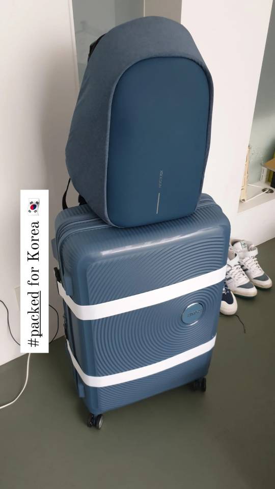
Korea 2022 - Prep ‘n stuff
Tomorrow is the day! On the 10th of September me and Sadea will fly to Korea for 3 weeks! On here I will share some ways we have planned our trip, encouraged by friends and colleagues who said this might be helpful to them and others. Sadea might also blog over here; sadeainkorea.blogspot.com and I too had a blog in 2012 in Dutch; meneerbert.waarbenjij.nu
In 2012 we both visited South Korea together with our friend Samantha. We had several penpals from South Korea at that point, so we planned to meet them that summer. We were also big fans of Korean pop. Initially we had planned to see the television music shows, but in the end we decide against it and instead focus on enjoying Seoul, Daegu and Busan.
Now 10 years later we are visiting South Korea again. We are planning a daring trip, visiting 8-10 cities in 3 weeks’ time. So we made a schedule and everything, which we hope will work for us and I’ll record here on my blog what the actual experience was. Cause, you know, we’re by no means experts.

Planning
For this trip we first planned the cities we’re visiting. We checked the public transport for them and drew it out on a map and created a spread sheet with a rough estimate of when we want to go where. As well as marking things as a ‘stay’ or a ‘day trip’. As you can tell, Jeju did not make it onto our schedule this time. We planned some less traveled places for tourism, such as Jeonju, Gwangju, Mokpo, Yeosu, Jinju and Pohang. The map is made in google’s MyMaps, it is available here.
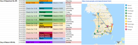
Above is the schedule in which we eventually added the time of all the hotel check-ins and check-outs. The days of the week and dates and the map overview.
Before that we obvious had to find our hotels. For this we both made lists of hotels we liked on booking.com, agoda.com, some discount website that was available via Thuisbezorgd. We saw we had discount at booking.com via our creditcards as well! Then we met and decided on all the hotels and booked them.

Unlike 2012 we booked mostly hotels this time around. Sometimes separate rooms, but mostly rooms with twin beds. Sadea added which had breakfast inclused and which didn’t. All the costs are totalled at the bottom of the spreadsheet and we settled the differences that we paid.
On the same page we made an estimate of most other costs we might make. Busses, train, sights, attractions and food.
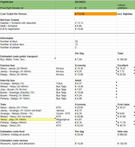
You can browse the spreadsheet and all its tabs over here.
Planning like this is not for everyone and its not needed, but it gived me peace of mind I’ve everything planned out. The first tab the spreadsheet opens on is emergency info, which is also for family so they know what time we are at which place.
Important on that page is that we’re gathered the addresses in Korean so that when we need help finding our accomodation, people have an easier time understanding the adresses.
It also has a packing list, a food list and a places to visit list.
The latter I used very little, because I like to mark things on Google Maps. Only to find out that we cant use Google Maps because it doesnt provide directions in Korea. So I’ve transferred most of my marked locations to Naver Maps.
My most favorite thing about naver maps is that it has streetview that’s 100x better than
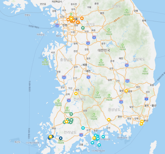
I’ve gone though some travel guides and blogs and marked the things I like on the map. For some cities I’m reading this blog called Colonial Korea and it’s been an eye-opener. I hope it will give me more appreciation for cities people have been saying are not worth our time.
So far we’re just looking forward to all the food haha.
Tomorrow is our flight.
Like sadea would say ‘awwww yeaaaaaa’.
0 notes

Text
Me: Why is Google Maps being slow?
Also me: has 1,526 places saved to various lists
#i don't have a problem#i HAD a problem and then i moved like 2000 places over to MyMaps#ignore#google maps
0 notes
Photo

How to create a "My Map" in Google Maps Go to Google Maps: | Google Maps Playlist: | How to create personalized, annotated, customized maps using Google Maps. source
0 notes
Link
2K notes
·
View notes
Last Seen Blogs

youareawesome
Untitled

phlebotomies
I'LL SHOW YOU!

kohai
kohai.io

shytalia
Hetalia Blog

pas79
Untitled