#glaciers carved up the landscape thousands of years ago and now there are all these really amazing huge bluffs and gorgeous valleys
Text
Don’t give me fucking Wisconsin tourism ads. I’m fucking from there. I lived there from ages 2 to 14. I’m well aware of what it does and doesn’t have to offer.
#I could do a ‘visit Wisconsin’ spiel right now highlighting all the things I like about it#but I’m also well aware of the seedy underbelly that you’re glossing over#for one as @thatstoocute rightly pointed out: Milwaukee is not. really a city.#if you want an actual city you are not gonna find one in Wisconsin#you’re gonna need to hit up Chicago or Minneapolis#but Wisconsin has really great local food and a lot of awesome lake towns#and the Wisconsin Dells are genuinely a lot of fun#and the views in Wisconsin especially the northern like half are my favorite in the world#glaciers carved up the landscape thousands of years ago and now there are all these really amazing huge bluffs and gorgeous valleys#also Door County is fantastic in general#the whole east coast is pretty beautiful too
12 notes
·
View notes
Photo

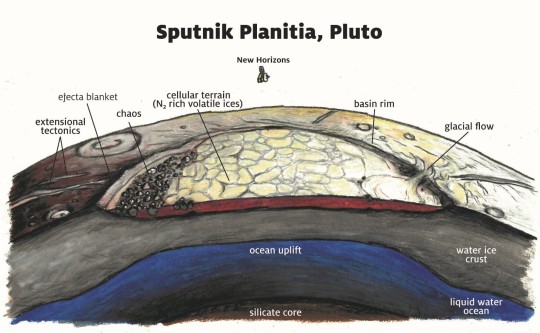


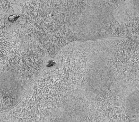
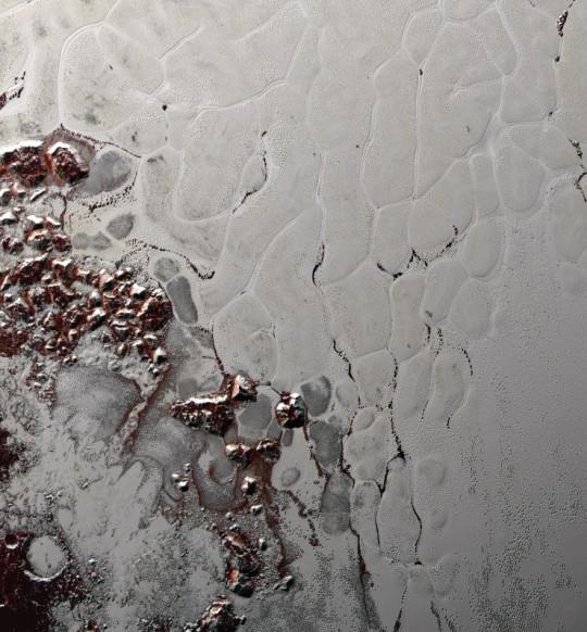


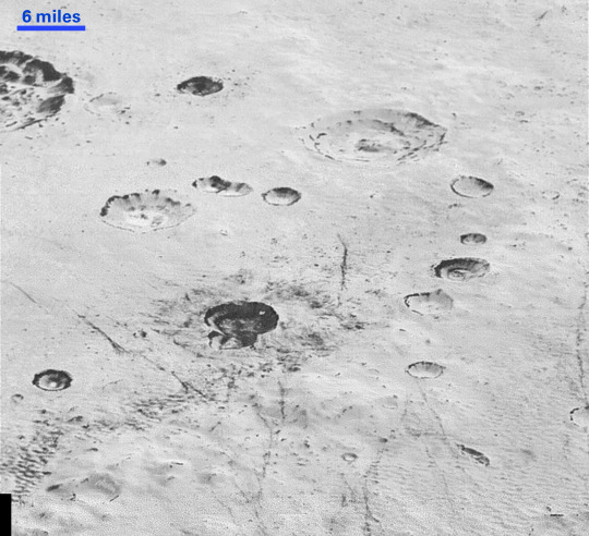
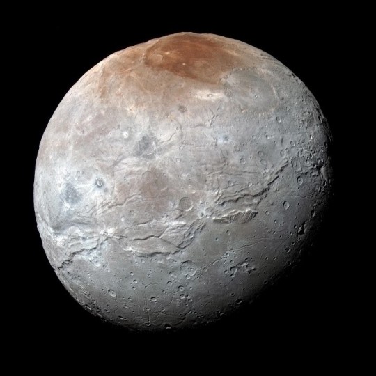
FIVE YEARS AFTER NEW HORIZONS’ HISTORIC FLYBY, HERE ARE 10 COOL THINGS WE’VE LEARNED ABOUT PLUTO Five years ago today, NASA’s New Horizons spacecraft made history. After a voyage of nearly 10 years and more than 3 billion miles, the intrepid piano-sized probe flew within 7,800 miles of Pluto. For the first time ever, we saw the surface of this distant world in spectacular, colored detail. The encounter -- which also included a detailed look at the largest of Pluto’s five moons, Charon -- capped the initial reconnaissance of the planets started by NASA’s Mariner 2 mission more than 50 years before, and revealed an icy world replete in magnificent landscapes and geology -- towering mountains, giant ice sheets, pits, scarps, valleys and terrains seen nowhere else in the solar system. And that was only the beginning. In the five years since that groundbreaking flyby, nearly every conjecture about Pluto possibly being an inert ball of ice has been thrown out the window or flipped on its head. “It’s clear to me that the solar system saved the best for last! We could not have explored a more fascinating or scientifically important planet at the edge of our solar system. The New Horizons team worked for 15 years to plan and execute this flyby and Pluto paid us back in spades!” -- Alan Stern, New Horizons principal investigator from the Southwest Research Institute, Boulder, Colorado. Scientists now know that, despite it being literally out in the cold, Pluto is an exciting, active and scientifically valuable world. Incredibly, it even holds some of the keys to better understand the other small planets in the far reaches of our solar system. Here are 10 of the coolest, weirdest and most unexpected findings about the Pluto system that scientists have learned since 2015, thanks to data from New Horizons. IMAGE 1....Enhanced color global view of Pluto, taken when NASA's New Horizons spacecraft was 280,000 miles (450,000 kilometers) away. (Credit: NASA/Johns Hopkins APL/Southwest Research Institute) Pluto has a “heart,” and it drives activity on the planet Sometimes you just have to follow your heart, and Pluto seems to have taken that advice quite literally. Pluto’s heart -- one of the signature features New Horizons observed on approach and imaged in high resolution during the flyby -- is a vast, million-square-mile nitrogen glacier. The heart’s left ventricle, called Sputnik Planitia, literally forced the dwarf planet to reorient itself so the basin now faces almost squarely opposite Pluto’s moon Charon. “It’s a process called true polar wander -- it’s when a planetary body changes its spin axis, usually in response to large geologic processes,” said James Tuttle Keane, a planetary scientist and New Horizons team member at the Jet Propulsion Laboratory in Pasadena, California. Sputnik Planitia’s current position is no accident. It’s a cold trap, where nitrogen ices have accumulated to make an ice sheet that’s at least 2.5 miles (4 kilometers) thick. The constant imbalance of that hefty mass, combined with the tidal yanks and pulls of Charon as it orbited Pluto, literally tipped the dwarf planet so the basin aligned more closely with the tidal axis between Pluto and Charon. “That event was also likely responsible for cracking Pluto’s surface and creating the many gigantic faults in its crust that zigzag over large portions of Pluto,” Keane said. The basin is thought to have formed to the northwest of its present location, and closer to Pluto’s north pole. And should ices continue to accumulate on the basin, Pluto will continue to reorient itself. But there’s more to that story... IMAGE 2.... There’s probably a vast, liquid, water ocean sloshing beneath Pluto’s surface Gathered ices may not be the only thing that helped reorient Sputnik Planitia. New Horizons data from the basin indicated there may be a heavier mass beneath it that played a part, and scientists suspect that the heavier mass is a water ocean. “That was an astonishing discovery. It would make Pluto an elusive ‘ocean world,’ in the same vein as Europa, Enceladus and Titan.” -- James Tuttle Keane, a planetary scientist and New Horizons team member at the Jet Propulsion Laboratory in Pasadena, California. Several other lines of evidence, including tectonic structures seen in New Horizons imagery, also point to an ocean beneath Pluto’s crust. Sputnik Planitia was likely created some 4 billion years ago by the impact of a Kuiper Belt object 30 to 60 miles (50 to 100 kilometers) across that carved out a massive chunk of Pluto’s icy crust and left only a thin, weak layer at the basin’s floor. A subsurface ocean likely intruded the basin from below by pushing up against the weakened crust, and later the thick layer of nitrogen ice seen there now was laid on top. Recent models based on images of the planet suggest that this liquid ocean may have arisen from a rapid, violent formation of Pluto. IMAGE 3....Pluto may still be tectonically active because that ocean is still liquid Enormous faults that stretch for hundreds of miles and cut roughly 2.5 miles into the icy crust covering Pluto’s surface. One of the only ways scientists reason Pluto got those fissures, though, is by the gradual freezing of an ocean beneath its surface. Water expands as it freezes, and under an icy crust, that expansion will push and crack the surface, just like an ice cube in your freezer. But if the temperature is low enough and the pressure high enough, water crystals can start to form a more compact crystal configuration and the ice will once again contract. Models using New Horizons data showed Pluto has the conditions for that type of contraction, but it doesn’t have any known geologic features that indicate that contraction has occurred. To scientists, that means the subsurface ocean is still in the process of freezing and potentially creating new faults on the surface today. “If Pluto is an active ocean world, that suggests that the Kuiper Belt may be filled with other ocean worlds among its dwarf planets, dramatically expanding the number of potentially habitable places in our solar system.” -- James Tuttle Keane, a planetary scientist and New Horizons team member at the Jet Propulsion Laboratory in Pasadena, California. But while Pluto’s liquid ocean likely still exists today, scientists suspect it’s isolated in most places (though not beneath Sputnik) by almost 200 miles (320 kilometers) of ice. That means it probably doesn’t contact the surface today; but in the past, it may have oozed through volcanic activity called cryovolcanism. IMAGE 4....Close up view of Wright Mons, one of two potential cryovolcanoes spotted on the surface of Pluto by the passing New Horizons spacecraft in July 2015. (Credit: NASA/Johns Hopkins APL/Southwest Research Institute) Pluto was -- and still may be -- volcanically active But maybe not “volcanic” in the way you might think. On Earth, molten lava spits, drools, bubbles, and erupts from underwater fissures through volcanoes sitting miles high in and protruding from the oceans, like on Hawaii. But on Pluto, there are numerous indications that a kind of cold, slushy cryolava has poured over the surface at various points. Scientists call that “cryovolcanism.” Wright Mons and Piccard Mons, two large mountains to the south of Sputnik Planitia, each bear a deep central pit that scientists believe are likely to be the mouths of cryovolcanoes unlike any others found in the solar system. To the west of Sputnik sits Viking Terra, with its long fractures and grabens that show evidence of once-flowing cryolavas all over the surface there too. And farther west of Sputnik Planitia is the Virgil Fossae region, where ammonia-rich cryolavas seem to have burst to the surface and coated an area of several thousand square kilometers in red-colored organic molecules no more than 1 billion years ago, if not even more recently. And speaking of recently... IMAGE 5....This detailed image of the glaciers in Pluto's Sputnik Planitia, about 50 miles wide, shows thousands of pits in its surface of nitrogen ice as well as larger circulation patterns. Scientists suspect the "Islands" are floating bergs of water ice, or perhaps the tips of ice mountains. (Credit: NASA/Johns Hopkins APL/Southwest Research Institute) Glaciers cut across Pluto’s surface even today, and they’ve done so for billions of years Pluto joins the ranks of Earth, Mars, and a handful of moons that have actively flowing glaciers. East of Sputnik Planitia are dozens of (mostly) nitrogen-ice glaciers that course down from pitted highlands into the basin, carving out valleys as they go. Scientists suspect seasonal and “mega-seasonal” cycles of nitrogen ices that sublimate from ice to vapor, waft around the dwarf planet and then freeze back on the surface are the source of the glacier ice. But these glaciers are not like our own water-ice glaciers here on Earth. For one, any melt within them won’t fall toward the bottom of the glacier -- it will rise to the top, because liquid nitrogen is less dense than solid nitrogen. As that liquid nitrogen emerges on top of the glacier, it potentially even erupts as jets or geysers. Additionally, there is the fact that some of Pluto’s surface is composed of water ice, which is slightly less dense than nitrogen ice. As Pluto’s glaciers carve the surface, some of those water-ice “rocks” will rise up through the glacier and float like icebergs. Such icebergs are seen in several New Horizons images of Sputnik Planitia, the largest of Pluto’s known glaciers, which stretches more than 620 miles (1,000 kilometers) across -- about the size of Oklahoma and Texas combined. IMAGE 6....Scientists from NASA's New Horizons mission used state-of-the-art computer simulations to show that the surface of Pluto's Sputnik Planitia is covered with churning ice "cells" that are geologically young and turning over due to a process called convection. (Credit: NASA/Johns Hopkins APL/Southwest Research Institute) Pluto has heat convection cells on its giant glacier Sputnik Zoom in close to the surface of Sputnik Planitia and you’ll see something unlike anywhere else in the solar system: a network of strange polygonal shapes in the ice, each at least 6 miles (10 kilometers) across, churning on the surface of the glacier. Although they resemble cells under a microscope, these aren’t; they’re evidence of Pluto’s internal heat trying to escape from underneath the glacier, and forming bubbles of upwelling and downwelling nitrogen ice, something like a hot lava lamp. Warm ice rises up into the center of the cells while cold ice sinks along their margins. There’s nothing like it in any of Earth’s glaciers, and or anywhere else in the solar system that we’ve explored! IMAGE 7....Pluto has a literal beating “heart” that controls its atmosphere and climate Cold and far-flung as Pluto may be, its icy “heart” still beats to a daily, rhythmic drum that drives Pluto’s atmosphere and climate much in the way Greenland and Antarctica help control Earth’s climate. Nitrogen ices in Pluto’s heart-shaped Tombaugh Regio go through a cycle every day, subliming from ice to vapor in the daytime sunlight and condensing back on the surface during the frigid night. Each round acts like a heartbeat, driving nitrogen winds that circulate around the planet at up to 20 mph. “Pluto’s heart actually controls its atmosphere circulation,” punned Tanguy Bertrand, a planetary scientist at NASA Ames Research Center in Mountain View, California. Sophisticated weather forecast models Bertrand has created using New Horizons data show that as these ices sublime in the northern reaches of Pluto’s icy heart and freeze out in the southern part, they drive brisk winds in a westward direction -- curiously opposite Pluto’s eastward spin. Those westward winds, bumping up against the rugged topography at the fringes of Pluto’s heart, explain why there are wind streaks on the western edge of Sputnik Planitia, a remarkable finding considering Pluto’s atmosphere is only 1/100,000th that of Earth’s, Bertrand said. They also explain some other surprising desert-like features... IMAGE 8....Close up of the water-ice mountains on the northwest fringes of Pluto's Sputnik glacier may provide the particles, and Pluto's beating nitrogen "heart" provides winds. (Credit: NASA/Johns Hopkins APL/Southwest Research Institute) Pluto has dunes It’s not the Sahara Desert, or the Gobi Desert. This is Pluto. Hundreds of dunes stretch over at least 45 miles (75 kilometers) of the western edge of Sputnik Planitia, and scientists suspect they formed recently. Dunes require small particles and sustained, driving winds that can lift and blow the specks of sand or whatever else along. And despite its weak gravity, thin atmosphere, extreme cold and entire surface composition of ices, Pluto apparently had (or still may have) everything needed to make dunes. Water-ice mountains on the northwest fringes of the Sputnik glacier may provide the particles, and Pluto’s beating nitrogen “heart” provides winds. Instead of quartz, basalt and gypsum sands blown by sometimes gale-force winds on Earth, though, scientists suspect the dunes on Pluto are sand-sized grains of methane ice carried by winds that blow at no more than 20 mph, although given the size of the dunes, the winds may have been stronger and atmosphere much thicker in the past. IMAGE 9....Pluto and Charon have almost no little craters, and that has some big implications Finding craters on the surface of planets is kind of the norm in space. But if there’s one abnormal thing about the Pluto system, it’s that neither Pluto nor Charon has many small craters -- they’re almost all big. “That surprised us because there were fewer small craters than we expected, which means there are also fewer small Kuiper Belt objects than we expected,” said Kelsi Singer, a New Horizons deputy project scientist and coinvestigator from the Southwest Research Institute in Boulder, Colorado. Analyses of crater images from New Horizons indicate that few objects less than about a mile in diameter bombarded either world. Because scientists have no reason to believe tectonic activity would have preferentially wiped the surface clean of these small craters, It could mean the Kuiper Belt is mostly devoid of very small objects. “These results give us clues about how the solar system formed because they tell us about the population of building blocks of larger objects, like Pluto and even perhaps Earth” Singer said. “Every time we go somewhere new in the solar system, we find surprises that challenge current theories. The New Horizons flyby did just that, and in many ways!” -- Kelsi Singer, New Horizons deputy project scientist and coinvestigator from the Southwest Research Institute in Boulder, Colorado IMAGE 10..... Enhanced color view of Pluto's largest moon, Charon. The colors are processed to highlight the variation of surface properties across the moon; most striking is the reddish north (top) polar region. (Credit: NASA/Johns Hopkins APL/Southwest Research Institute) Charon had a volcanic past, and it could be key to understanding other icy worlds New Horizons also captured stunning images of Pluto’s moon Charon, and they revealed some surprising geology there too. On the side of Charon that New Horizons imaged in high resolution, Charon has two distinct terrain types: an immense, southward-stretching plain officially called Vulcan Planitia that’s at least the size of California, and a rugged terrain colloquially called Oz Terra that stretches northward to Charon’s north pole. Both seem to have formed from the freezing and expansion of (you guessed it!) an ancient ocean beneath Charon’s crust. Moderate expansion in the north created the rugged, mountains terrain of Oz Terra seen today, whereas the expansion in the south forced its way through vents, cracks and other openings as cryolava, spilling across the surface. In fact, Vulcan Planitia is thought to be a giant cryoflow that covered the entire region early in Charon’s history. Similar features exist on some icy satellites all around the solar system, including Neptune’s giant moon Triton, Saturn’s moons Tethys, Dione and Enceladus, and Uranus’ moons Miranda and Ariel. And thanks to the detailed images of Charon from New Horizons, the models of Charon’s past be a Rosetta Stone to aid in understanding the volcanic and geologic activity of those other icy worlds too. “New Horizons transformed Pluto from a fuzzy telescopic dot, into a living world with stunning diversity and surprising complexity. We were all astounded by the range of phenomena in the entire Pluto system, from Charon’s polar coloring and giant chasm, to the ‘iceball’ makeup of the four smaller satellites that offered valuable clues to the system’s origins. The Pluto encounter was exploration at its finest, a real tribute to the vision and persistence of the New Horizons team.” -- Hal Weaver, New Horizons project scientist at the Johns Hopkins Applied Physics Laboratory in Laurel, Maryland.
69 notes
·
View notes
Text
Siberian History (Part 2): Prehistory
In 1928, a Paleolithic home was discovered underground. Its foundation was made of mammoth tusks and other animal bones, pressed down at the base with limestone plates. The roof's scaffolding was reindeer antlers meshed together. In the middle of the house was a hearth with an oval grave, where a child had been elaborately buried with many ornaments. One of the ornaments was a headband resembling a diadem; another was a carved pendant that depicted a bird in flight. The child had a double row of teeth – this sort of deformity was once associated with supernatural powers, which could explain the elaborate burial.
Other nearly-prehistoric settlements have been discovered from the Ob River to the Transbaikal. The remains of Neolithic houses have been found all over Siberia. There are extremely old inscriptions & pictographs opn the cliffs and stratified palisades of the Yenisei River. Along the Lena River are rock drawings that include a giant horse, wild bison and two elk.

Rock paintings on the banks of the Lena River.
The Pleistocene Epoch lasted from 2.6 million years ago to 11,700 years ago. During this time, much of the territory was covered in mountain glaciers, and the whole north-western plain was locked in a glacial sheet. Huge mammoths travelled northwards from northern India to south-central Siberia, where greenery & flowers had started to grow in patches across the steeply rolling terrain. There were also the wooly rhinoceros, wild bison, sabre-toothed tiger, and saiga antelope (the lat one still survives in Central Asia, but is endangered).
As the glaciers receded, huge inland seas formed and trees flourished in the Arctic. The stomachs of some of the mammoths that have been found contain vegetation (such as buttercups) that now grows far to the south of where they died – so the vegetation in these regions once flourished far more than nowadays.
The Siberian landscape changed over thousands of years. The seas disappeared, the land was re-elevated, and major rivers formed. People began to live along the riverbanks and make their homes there. They domesticated wolves into dogs and built wooden dwellings. The hunters improved their stone tools – bows & arrows made out of wood; harpoons made from reindeer antlers; fish-hooks made from bone. They also began to experiment with different types of arrowheads and spears. They learned how to make light, highly-manouevrable canoes from birchbark.
By the end of the Neolithic Period (c. 2400 BC), all of Northern Asia was inhabited, most densely around Lake Baikal in the heart of the taiga. The hunters ventured northwards from the taiga into the tundra and reached the shores of the Arctic Ocean. There, they set up tall, conical skin tents that were collapsible. These were a prototype of the tipi that later spread to the shores of North America.
Following the Neolithic Period was the Bronze Age (c. 2400 – 800 BC). The first metal tools appeared around 2000 BC – knives, fish-hooks and needles that were cold-forged out of native copper, probably found by hunters in the mountains. Much later, the Siberians developed clay molds and used them to cast knives and swords.

Bronze socketed axe (1100s - 800s BC).
By the beginning of the 1000s BC (i.e. not long after 2000 BC), tribes of cattle breeders were roaming the steppes of Western Siberia. They began to cultivate the soil with a stone hoe, and ground the grain by hand.
Horse cultures also developed. During the Bronze Age, the people living in the Minusinsk Basin (an oasis between the Altai & Sayan Mountains, in the upper part of the Yenisei River Valley), had great skill in metalwork. Many bronze implements have been found in their burial mounds.
#book: east of the sun#history#prehistory#geography#geology#pleistocene epoch#paleolithic period#neolithic period#bronze age#siberian bronze age
2 notes
·
View notes
Link
THEY APPEARED as the last glacier retreated, twelve thousand years ago. It was the end of Earth’s last ice age, the Wisconsin Glaciation, when vast snowy sheets descended over much of the planet. As the ice drew back, it carved the landscape as it is today and made way for humans, who named themselves the Original People. Other tribes, in time, would come to call them the Ancient Ones.
The Menominee, as they are now known, evolved as the land did, moving with the seasons up and down the length of modern-day Wisconsin. As the tundra sprouted a seemingly infinite forest, trees became a cornerstone of life. The Menominee made wigwams from basswood bark and cedar, canoes and containers from birch. The tallest trees were revered as grandfathers, sheltering plants on the forest floor below as they reached high toward the Creator.
Thousands of years into this way of life, early American colonizers invaded from the east. It took them a century to completely dismantle the world as the Menominee knew it; the tribe was forced to cede its territory in one treaty after another, and a booming logging industry grew up on the newly acquired land. The Menominee lost their remaining ancestral lands the year Wisconsin became a state. After refusing to move elsewhere, the tribe fought for a small piece of their homeland back, establishing what is now the Menominee reservation.
After loggers had cleared all but this reservation, the stripped land was sold off to an incoming wave of German immigrant farmers. By 1872, the state dairy association had formed; in 1899, more than 90 percent of Wisconsin farms raised dairy cows. In 1915, the state was producing more butter and cheese than any other in the country. The Germans were Catholics as well as farmers and did their best to impose both identities on the tribe, prying children from their parents for boarding school and attempting to carve the communal reservation into individual farms. But while Catholicism made a lasting mark, the Menominee rejected this new kind of agriculture almost entirely.
Millennia in this place had taught them they could harvest the forest so that, in the words of their famous chief Oshkosh, the “trees will last forever.” Over the following decades, they became renowned for this forest, which remained healthy and fostered old growth even as the tribe supported itself by cutting millions of trees. To this day, the forest is so dense that the reservation’s sharp outline is visible from space—a tiny island of trees in a sea of Holstein-speckled farmland. Trees cover 95 percent of the ground. It isn’t an artificial monoculture, arranged in neat plantation rows, but a lush symbiotic mix of maple and aspen and birch that looks wild and untouched. Though the Menominee have logged off more than 2 billion board feet of lumber since they began logging 160 years ago, there is, remarkably, more tree cover here now than there was in 1854. The marvel of that feat draws researchers from institutions like the Smithsonian and from countries as far away as Germany and South Africa to the forest, all eager to learn the secret.
And yet, after all the Menominee have gone through to lay claim to their ancestral land, the delicate ecosystem they’ve cultivated to survive is now threatened by the biggest climatic change since the time of the glaciers. Temperatures have climbed so high, so quickly, that the forest may be altered forever in a slow moving storm of heavy rain, drought, invasive species, and heat.
The Menominee reservation, like islands around the world in the age of climate change, is in danger of disappearing.
[Continue Reading]
18 notes
·
View notes
Text
Great Lakes and Midwest geology (including a 4-inch sinking of Chicago over the past 50 years) tell us stories about long-ago changes to the climate
Long post, but fun, particularly if you live anywhere in the Midwest or in Canada.
The Chicago Tribune published two stories today about the glaciers that crept over the northern part of the North America, in places scraping away the previous landscapes of hills, bluffs and canyons, creating the flat landscape that we now see in parts of the Midwest, including most of Illinois and the Chicago area. When the glaciers melted, the melt filled up the basins that had been carved by the glaciers, forming the Great Lakes. One of the stories is about the glaciers, and the other tells us that parts of the Midwest are sinking while Canada is rising, screwing up the flow of water around the Great Lakes.
The first story is entitled, “The massive glacier that formed the Great Lakes is disappearing — and greenhouse gases are to blame for its untimely demise.” The other is entitled, “Chicago is sinking. Here’s what that means for Lake Michigan and the Midwest.”
All the information in here.......because of ancient climate change. Those changes happened over thousands of years, so local wildlife, botany and people had a lot of time to adapt. Our current edition of climate change? Now, decades rather than thousands of years, not giving much time to adapt.
The glacier that covered the Great Lakes has been called the Laurentide Ice Sheet. It expanded and contracted as the climate changed. At one point, it was 3,000 feet thick over Chicago, about twice the height of the Willis Tower (aka Sears Tower). All that’s left of the Laurentide Ice Sheet is a small glacier called the Barnes Ice Cap, about the size of Delaware and located on Baffin Island in Canada. But after 2,000 years of stability, the Barnes Ice Cap is melting, due to global warming, and is expected to vanish in the next 300 years. These maps help visualize where all this happened:


A University of Colorado student stands near a stream formed by melting ice on the Barnes Ice Cap, the last remnant of the Laurentide Ice Sheet that once covered Chicago. The Barnes Ice Cap is on Baffin Island in the Canadian territory of Nunavut. (Gifford Miller / University of Colorado 2010)
In the other story, we learn that parts of the Midwest are sinking, while parts of the northern Midwest and Canada are rising. Some estimate the sink to be around 4 inches over the past 50 years. Why? Because as the glaciers receded, they removed tons of weight on the land, and as the weight lifted, the land rises. The glaciers receded most recently over parts of the northern Midwest and Canada, so those parts are rising. As they rise, the magma in the Earth from the south, i.e., the rest of the Midwest, squirts to the north to fill the void, and the land to the south subsides, or sinks. And as that land sinks, the flow of water around Lake Michigan and from Lake Superior into Lake Michigan and Lake Huron changes.
These maps and graphics might help:

7 notes
·
View notes
Link
Venice is Florida's unofficial capital of fossil hunting. Divers and beachcombers flock to this city on the Gulf Coast, mostly seeking palm-sized teeth of the Megalodon, the enormous shark species that went extinct 2 and half million years ago. In the summer of 2016, a diver searching for those relics picked up a barnacle-crusted jaw from a shallow spot off the shore of Manasota Key. The specimen sat on a paper plate in his kitchen for a couple weeks before he realized it was probably a human bone.
The diver sent a picture to Florida’s Bureau of Archaeological Research, where it landed in front of Ryan Duggins, the bureau’s underwater archaeology supervisor. A single molar was still attached to the jawbone, and the tooth’s cusps were worn smooth, likely from a diet of tough foods. “That’s something we don’t see in modern populations, so that was a quick indicator we were dealing with a prehistoric individual,” Duggins explains.
With a team of fellow underwater archaeologists, Duggins relocated the dive spot about 300 yards from the shore and 21 feet below the surface. “As soon as we were there it became clear that we were dealing with something new,” Duggins recalls. First, he spotted a broken arm bone on the seabed. Then, when he noticed a cluster of carved wooden stakes and three separate skull fragments in a depression, Duggins realized he might be dealing with a Native American bog burial site—one that had been inundated by sea level rise, but was miraculously preserved.
The discovery was announced today by the Florida Department of State.
During the last ice age, the Floridian peninsula looked more like a stubby thumb than an index finger. But beginning around 14,000 years ago, the global climate began to warm, causing glaciers to melt and sea levels to rise. Florida shrank over the next several millennia, and countless places where prehistoric people once lived, hunted, and buried their dead disappeared beneath the waves.
Marine archaeologists traditionally believed those now-submerged sites would be too fragile and ephemeral to survive the violent thrashing of the sea. “The vast majority of underwater archaeological projects have historically been focused on shipwrecks,” Duggins says. However, in the past couple of decades, some prehistoric sites, mostly scatters of stone tools, have been identified off Florida’s coast. Duggins thinks what he found near Manasota Key proves these underwater landscapes have much more archaeological potential.
In 2017, the team went back to the site to excavate a small test unit. They carefully dug through layers of peat beneath the seabed, sometimes using chopsticks and pastry brushes. They found densely packed organic remains, including more human bones, sharpened wooden stakes and textile fragments. Radiocarbon tests on the wood indicate the site dates to 7,000 years ago, during the Early Archaic period, a time when Florida’s hunter-gatherers were starting to live in permanent villages and adopt a sedentary lifestyle. So far, the researchers have counted a minimum of six individual sets of human remains, but “there’s probably going to be a lot more,” Duggins says, adding that their surveys of the site suggest the whole graveyard could spread across an acre.
Archaeologists already know that some ancient Floridians during this time period buried their dead in shallow, peat-bottomed ponds. In the 1980s, construction workers found human remains while clearing muck from a pond near Cape Canaveral on Florida’s east coast. Excavations at the so-called Windover site revealed an 8,000-year-old peat graveyard with more than 160 skeletons, some with their brains still preserved, as well as wooden stakes and textiles. Similar burial practices were also found at sites like Ryder Pond, Republic Groves and Bay West, Duggins notes, but all of these were inland.
“What we currently are thinking is that when an individual passed, they would have been wrapped in handwoven fibers and sunk to the bottom of the pond,” he explained. “A series of fire-hardened and sharpened stakes would be pounded into the pond bed around the body with the tops of those stakes protruding above the water line.”
Similarly, Duggins thinks the site near Venice would have been a watery graveyard, a small pond in a marsh made up of infilled sinkholes and natural springs, at a time when the site was likely 10 feet above sea level and part of Florida’s mainland.
Michael Faught, an archaeologist who pioneered prehistoric underwater archaeology in Florida, says the Manasota Key Offshore site has “impressive preservation of organic material that are rare terrestrially.”
“These items can help us reconstruct environment, subsistence, and cultural behaviors, and these data can be used to see how behaviors evolved over time, or if there are new immigrants to the area, or both,” Faught adds.
That scientific information hasn’t been gleaned from the human remains and artifacts just yet. The bones are undergoing a slow drying and desalination process at the Forensics Studies Lab run by anthropologist Heather Walsh-Haney at Florida Gulf Coast University. Once the bones enter the collection of Florida’s Bureau of Archaeological Research, the department will send out a nationwide notice to Native American tribes who may want to claim ancestry of the remains and have them repatriated under the Native American Graves Protection and Repatriation Act. Duggins is already consulting with the Seminole Tribe of Florida on respectful treatment of the remains.
“We are happy to be working, shoulder to shoulder, with the Bureau of Archaeological Research and the residents of Manasota Key to identify a preservation plan that will allow the ancestors to continue to rest peacefully and without human disturbance for the next 7,000 years,” Paul Backhouse, the tribal historic preservation officer for the Seminole Tribe of Florida, said in a statement.
Duggins has also been trying to raise awareness locally with groups like the Manasota Key Association that could help keep watch over the underwater graveyard. In Florida, removing items from an archaeological site without authorization is a misdemeanor; knowingly disturbing an unmarked grave is a felony. Thousands of people visit the nearby beaches and waters, and archaeologists don’t want a site that’s remained largely intact for millennia to be destroyed by mundane activity, like anchor dropping, or worse, looting.
“We only know about it because someone came forward,” Duggins says.
72 notes
·
View notes
Text
EXPLORE AMERICA'S INCREDIBLE HIDDEN GEMS THIS SUMMER
PARKS & RECREATION
EXPLORE AMERICA'S INCREDIBLE HIDDEN GEMS THIS SUMMER
Lately, we've been feeling the urge to explore hidden gems in our nation's backyard, like the majestic Bryce Canyon National Park, pictured above. Did you know that the thousands of famous spires of rock that comprise this otherworldly landscape are called "hoodoos"? Well now, you do! While lesser known than its neighbor Zion National Park, Bryce Canyon is one of many destinations in the U.S. you may have previously overlooked.
In the spirit of overlooked overlooks, below are four places with breathtaking views, plenty of space, and excellent nearby accommodations you shouldn't miss this summer. After all, this land was made for you and me.
HORSESHOE BEND: A DESTINATION ONE BILLION YEARS IN THE MAKING
WHERE TO STAY: CAMP SARIKA BY AMANGIRI (NEW!) | UTAH
Heed the call of the Wild West. The Grand Circle region of Utah features some of North America's most intriguing and protected landscapes. Best known for the Grand Canyon, Zion National Park, and Monument Valley, it is also home to the not-to-be-missed Bryce Canyon National Park, Antelope Canyon, and Horseshoe Bend.
Serving as your home base, Camp Sarika by Amangiri is new for 2020 and unlike any campsite you've ever seen. This luxury desert resort is now open and an exclusive way to experience the grandeur of our West.
Private perks:
✅ Upgrade upon arrival
✅ Full daily breakfast for two
✅ $125 spa credit per person
✅ Early check-in
✅ Late check-out
✅ Complimentary wifi, and more
CHANNEL ISLANDS: DAY TRIP TO CALIFORNIA'S TREASURED ISLANDS
WHERE TO STAY: ROSEWOOD MIRAMAR BEACH | CALIFORNIA
Channel your inner explorer on a day trip to California's little-known Channel Islands National Park. Located an hour boat ride off the coast of Southern California, this chain of eight pristine islands - five of which comprise the national park - is the perfect respite from the congestion of urban life. Santa Cruz, Anacapa, Santa Rosa, Santa Barbara, and San Miguel are home to over 2,000 plant and animal species, 150 of which are found nowhere else in the world! Aptly nicknamed "North America's Galapagos" and rich with untouched beauty, these isles offer plenty of opportunities for outdoor adventuring. Santa Barbara Channel is home to over 30 marine mammal species including whales, dolphins, and elephant seals, as well as marine life ranging from sea stars and anemones to blue whales, the largest animals in the world.
After a day of exploration, retreat to seaside Rosewood Miramar Beach hotel, newly opened in 2019. Just 80 miles northwest of Los Angeles, the resort’s spacious, stylish bungalows are the epitome of California cool.
Private perks:
✅ Upgrade upon arrival
✅ Full daily breakfast for two
✅ One a la carte lunch for two
✅ Early check-in
✅ Late check-out
✅ Complimentary wifi, and more
GRAND TETON NATIONAL PARK: INTO THE WILD
WHERE TO STAY: FOUR SEASONS RESORT JACKSON HOLE | WYOMING
While visiting in the summer, it's easy to forget that ice is to thank for Grand Teton National Park. Starting two million years ago, glaciers formed what is now the youngest mountain range in the Rockies. Ice up to 3,500 feet thick flowed across the valley floor and down the mountains, carving the iconic landscape. The six sparkling glacial lakes now act as reflecting pools to the park's eight peaks for some of the most dramatic views in the West. Grand Teton's 310,000 acres make it easy to safely keep your distance while surrounded by unparalleled natural beauty. Embark on a private wildlife safari to marvel as bears, bison, elk, and wolves roam their natural habitat, fly fish on Snake River, or discover hidden pockets of Grand Teton and nearby Yellowstone.
While the landscape is immense, no detail is too small at Four Seasons Resort Jackson Hole. This summer getaway may even inspire you to book your return visit during ski season.
Private perks:
✅ Upgrade upon arrival
✅ Full daily breakfast for two
✅ Early check-in
✅ Late check-out
✅ Complimentary wifi, and more
SHENANDOAH NATIONAL PARK: RETHINK YOUR SKYLINE
WHERE TO STAY: THE INN AT LITTLE WASHINGTON | VIRGINIA
They may be half the age of Horseshoe Bend, but the 500 million year old Blue Ridge Mountains have had plenty of time to come into their own. Shenandoah National Park provides beauty and serenity in spades - just 75 miles from Washington D.C. The star of the show is Skyline Drive, a 105 mile stretch of scenic overlooks, trailheads, and picnic areas to take in the natural beauty of this park.
Stay in a town originally laid out by George Washington when he was seventeen years old. Where comfort meets opulence, The Inn at Little Washington, a Relais and Chateaux property, is a sumptuous home away from home. Be sure to take part in the Inn's dining experience, again awarded three stars by Michelin, their highest accolade.
Private perks:
✅ Upgrade upon arrival
✅ Full daily breakfast for two
✅ $100 credit at the Tavern Shops
✅ Early check-in
✅ Late check-out
✅ Complimentary wifi, and more
CONTACT US NOW TO BOOK YOUR NEXT GETAWAY
0 notes
Text
South America is a distant dream for me, far away from India, a land of remarkable alpines, dense forests, multihued cities, and of course Machu Picchu in Peru. Rann of Kutch in Gujarat reminds me of my dream trip to the salt flats of Bolivia. A diverse continent with various countries of different natural marvels, there are some amazing places to see in South America. So, here is my South America bucket list with all the breathtaking places to visit in South America.
Breathtaking places to visit in South America
1. See the Amazon Rainforest
Flying into Leticia, Colombia I watched in awe the sea of green trees below me seem to go on forever. We hired a local to take us by boat 2 hours up the Amazon river to an untouched portion of the rainforest far from town. I traveled during the rainy season which gave my Amazon experience the added bonus of canoeing through the rainforest canopy.
Photo by Geena Truman
Five hours of canoe-ing through dense vegetation. Macaws, howler monkeys, iguanas, squirrel monkeys, and an array of other wildlife just 10 feet above our heads. Our guide, Armando, hacking our path through the jungle with a long machete. The experience was surreal. Just the three of us completely immersed in the rainforest. The deafening sounds of insects and animal calls never stopped. We slept deep in the rainforest on a hammock constructed on a floating platform in the middle of a lake. Our nighttime search of Caiman, candlelight dinner on the floor of our floating platform and early morning canoe around the lake were highlights of our two days in the jungle. We got to know about the jungle. A bucket-list adventure that I didn’t even know I had. To sleep in the jungle and experience the serenity and peacefulness of nature around me. Visiting the Amazon Rainforest will forever be high in my list of travel adventures.
– Geena Truman | Bartender Abroad
Don’t miss this awesome 10-day Itinerary for Peru!
Peru
2. Trek for Machu Picchu
So many other travelers warned me that Machu Picchu was “too touristy” and too busy with people. While all of these warnings may have lowered my expectations, upon arriving I was actually blown away by just how extraordinary Machu Picchu was.
Machu Picchu is one of the best places to visit in South America!
Photo by Pixabay on Pexels.com
Yes, there were many tourists there but that didn’t make the incredible feat of building a village on the side of a mountain out of stone any less incredible. The workmanship of the Incas is astounding and to this date, Machu Picchu is still one of the most magnificent things I’ve ever seen!
– Bailey Busslinger | Destination Less Travel | Facebook
3. Islas Ballestas
Islas Ballestas is also called the poor man’s Galapagos, but don’t think it is, therefore, less interesting. The group of islands before the coast of Peru just south of Lima has an incredibly rich biodiversity with a variety of birds and marine wildlife. It’s a biologists dream and a paradise for those that love nature and animals.
Photo by Ellis Veen
Islas Ballestas is easy to reach with daily boat tours from Paracas, only 4 hours away from Lima. It’s almost sure you get to see the sea lions that like to spend their day sleeping at the rocky islands. Pelicans are another guaranteed sight and if you are lucky you may see penguins, dolphins or flamingos. From August to October, you might even see humpback whales.
The sea may be rough but it all adds up to the adventure that does not stop at the islands. Paracas is surrounded by stunning desert landscapes. The nearby Paracas Natural Reserve and the small town of Huacachina with its sand dunes offer much more beauty and adventure in Peru.
– Ellis Veen| Backpack Adventures
4. Visiting the floating villages on Lake Titicaca
Lake Titicaca is located at the border between Peru and Bolivia at an elevation of over 3,800 meters above sea level and is the highest navigable body of water in the world. Until today, around 5,000 people live on artificial islands that float on the surface of Lake Titicaca. The Uros People have built their own islands with totora reeds for centuries and still do so today.
Photo By Mike
The floating villages can be visited from both the Peruvian and the Bolivian side of the lake. Most visitors visit the islands on short day trips which include a short-stop on several of the islands and a few explanations of the fascinating everyday life of the Uros People. However, if you want to learn more about life on Lake Titicaca, you can also organize a homestay at one of the islands with one or more overnight stays. We spent two days at one of the islands in Bolivia, one of the safest countries in South America. On day one, we went on a boat trip where we learned how the islands are constructed and how to cut the totora. We also learned about the fishing and cooking techniques of the Uros People. Our trip to the Uros island was definitely one of our most amazing experiences in South America.
– Mike | 197TravelStamps
5. Rainbow Mountain
Located just a few hours outside of Cusco, it’s hard to believe that Rainbow Mountain was only discovered to tourism a few years ago. But now the secret’s out, Peru’s colorful summit is fast becoming one of South America’s most popular attractions – and it’s easy to see why.
Photo by Julianne Oliveri
At first glance, you’d think the photos were photo-shopped but, believe it or not, those multi-colored peaks are for real.
Guided hikes are the best way to experience Rainbow Mountain and the views along the ascent are just as breath-taking. You’ll pass through vast valleys dotted with friendly alpacas, snow-capped mountains, and even giant glaciers before you start to see the colors of the rocks transform before your eyes. Standing at the summit and seeing Rainbow Mountain in all its colorful glory is an absolute “bucket-list” essential and something you’ll never forget!
– Julianne Oliveri | Part-Time Passport
6. Colca Canyon
Colca Canyon should be on every South America bucket list. The canyon is the second deepest in the world and a unique place to spot the Andean Condor, one of the largest birds in the world. You could go on a day trip or do a two- or three-days hiking tour of Colca Canyon. All the options take you to Cruz del Condor viewpoint which is the place you are most likely to see condors hunting in the morning.
Photo By Linn Haglund
The hiking tours take you down to the bottom of the canyon where vegetation is lush and green with an abundance of fruit trees. You will stay one or two nights at the bottom of the canyon before the final day of hiking takes you straight up to the top in only a few hours. Be prepared, it is a hard hike but totally worth the experience.
– Linn Haglund | Brainy Backpackers
7. Flying over the Nazca Lines
In the midst of arid Nazca Desert in Peru, a series of giant carvings have been puzzling scientists and archaeologists for decades. These geoglyphs are the Nazca Lines – figures of humans, animals, birds, trees, flowers and other objects with mysterious origins.
Photo By Alex Trembath
It is believed that the lines were sculpted in the desert by the Nazca people around two thousand years ago. But the big mystery is their purpose. Theories have been suggested, but nobody knows for certain why these breathtaking carvings were created in the first place.
From a small airport just outside Nazca city, you can take a short flight to see the most famous of the carved figures from above, such as the monkey, the hummingbird, and the astronaut. You need to arrive early and be prepared to wait for a while before taking to the air, but it’s worth the effort to see one of the world’s greatest creative mysteries.
– Alex Trembath | Career Gappers
Chile
8. Wine tasting
When it comes to wine tasting, Chile’s wine regions rank right up there with those of France, Italy, and California. Though it’s one of the youngest wine regions in the world (rising to popularity in just the past thirty years), it’s already one of the most sought after and is known the world over for its chardonnays, it’s Sauvignon Blancs, and its cabernet sauvignons.
Photo By Ashley Smith
When in South America, sampling your fair share of Chile’s wines is a fun and eye-opening experience. You can go for full, formal tastings, tour the wineries, or book a guided tour on a “wine bus” to sample many of the area’s products.
– Ashley Smith | My Wanderlusty Life
9. The Atacama Desert
In my bio, it says “go to space one day” which I’m not sure I’ll manage unless I win the lottery. That’s why the Atacama Desert in Chile is one of my favorite places on earth. It’s so alien! Moon landscapes, mars landscapes, surreal lagoons with salt flats and blue skies with pinkish volcano’s lining up. The geysers and rainbow mountains make the landscape complete. All this at an altitude of 4000 meters and up reaching towards space.
Photo By Chris W.
One day I want to make another Atacama Desert trip and I recommend everyone to put it on their bucket list for South America.
– Chris W. | Chris Travel Blog (CTB Global)
10. Easter Island
It may be difficult and expensive to get to Easter Island: a five and a half hour flight from the Chilean Capital of Santiago, or four hours from Tahiti. Either way, Easter Island is a magical place that deserves a spot on your South America bucket list, even though it is in the middle of the Pacific.
Easter Island is home to over 400 moai head statues that are mysteriously scattered throughout the island, earning Easter Island a spot as a UNESCO World Heritage Site. Don’t miss these important things to see on Easter Island: the Rano Raraku birthplace quarry, Ahu Tahai, and Ahu Tongariki statue platforms, Anakena Beach, and the dormant Rano Kau volcano.
Photos by Halef & Michael
My favorite is the humble Anthropological Easter Island Museum, where you can learn more about the almost mythical Rapa Nui culture. It also houses many interesting objects, such as the only female moai on the island, a surviving moai eyeball, and several other important Rapa Nui artifacts.
– Halef & Michael | The Round The World Guys
11. Torres del Paine Aka W Trek
In the southernmost part of Chile, in South America’s famed Patagonia region, lies one of the most naturally beautiful places in the world – Torres del Paine National Park. Filled with some of the most stunning turquoise lakes, jagged peaks, and sweeping landscapes, Torres del Paine is easily worth the long journey to get there.
Photo By Kay
After visiting Torres del Paine on two separate occasions, I’d highly recommend doing a multi-day trek to explore the various mountains, glaciers, and rock formations in the park. The most famous of these multi-day hikes is the 5-day W Trek in Torres del Paine. Taking adventurous hikers to some of the most iconic spots in the park, like the Mirador Base de las Torres and Glacier Grey, the W Trek in Torres del Paine is achievable even for hikers who have never done a multi-day trek before.
– Kay | Jetfarer
12. Grey Glacier
Grey Glacier is one of the most spectacular sights in the Torres del Paine national park, located in Southern Chile’s Patagonia. It is one of the smallest glaciers in the Southern Patagonian impressive ice field. But with its unique grey-blue color and breathtaking mountain backdrop, there is no doubt that Grey Glacier belongs on your South America bucket list. The blue color is so intense it can be seen from space.
Photo By Julie
There are a few different ways you can experience the beauty of the glacier. You can access it as part of the famous W and O treks, by taking a boat or a kayak across Lago Grey, and finally by ice trekking the glacier! The boat tour will treat you to the most gorgeous vistas of the sparkling blue glacier, with towering snow-capped mountains in the background. If you get lucky enough to visit the park on a bright sunny day and catch a reflection of the glacier in the lake, you will experience one of the most beautiful panoramas in South America.
– Julie | Wandering Sunsets
Ecuador
13. The Galapagos Islands
A trip to the Galapagos Islands is one of those rare dream trips that transports you into a natural universe, a world where wildlife rules and the scenery is awe-inspiring. From strange moon-like islands to the lushness of the highlands of Santa Cruz, the Galapagos offers a vast range of terrain and is one of the few remaining unspoiled regions of the world. This breathtaking volcanic archipelago is so remote it harbors animal and plant species found nowhere else in the world.
Photo By Carol Perehudoff
Sitting approximately 1,000 km off the Ecuadorian coast, the islands were visited by Charles Darwin in 1835, and have developed an almost mythical fascination for adventurous travelers. While the easiest way to explore is with a Galapagos cruise, island hopping is also possible – and can be more budget-friendly – though independent travelers are more limited in where they can go. Activities include hiking, paddle boarding, kayaking, and snorkeling, and you may be accompanied by curious animals both in the water and on the ground.
– Carol Perehudoff | Wandering Carol
14. Cycling down the Andes
One of the highlights of South America for me was cycling down the Andes along the Route of the Waterfalls from Banos to Puyo in Ecuador. The route starts in Banos, a small town dramatically perched on the edge of a deep ravine in the shadow of a towering active volcano. There are several places in town to rent a bicycle. The nice thing about this day trip is that most of the cycling is downhill!
Along the route, you will pass waterfalls gushing down the cliffs beside you and even trickling over the road in front of you. Stop off at the Devil’s Cauldron – dramatic waterfalls plunging down a steep cliff that you can reach via a series of wooden steps and walkways. With millions of droplets of water glistening in the sunshine, this is a delightful stop.
Photo By James
You can end your trip here and flag a passing truck to take you and your bike back up to Banos, or continue further downhill. The scenery gradually changes and the cool alpine air becomes thick and steamy as you reach the Amazon rainforest. In Puyo, there are trucks or buses to take you back to Banos, where you can soak in the hot springs that give it its name – a perfect end to the day.
– James | Travel Enthusiast
15. Quilotoa Lake
Up in the mountains of the Ecuadorian Andes is a hidden gem called the Quilotoa Lake, or Laguna Quilotoa in Spanish. You might be wondering what a lake is doing at over 3900m (~12800ft) above sea level. A long long time ago, this was a volcano and an immense eruption (VE I-6) occurred, causing this 3km (2-mile) wide caldera to form. Nowadays, it is a crater lake. The colors are beautiful due to the minerals that are dissolved in the water. The whole lake takes about 6-hours to circle and there are many insane viewpoints along the way.
Photo By Sean Lau
If you enjoy the beautiful scenery along with a great hike, this is a place you have to visit. Keep in mind that weather is a little erratic when you are in this altitude, so just pack accordingly!!
– Sean Lau| LivingOutLau|
Argentina
16. Fitz Roy
The Fitz Roy in Argentinian Patagonia is easily the most famous mountain on the Argentina side of the region. It’s is so iconic, it’s featured on the Patagonia clothing label. Though the particularly adventurous can rock climb it, one can reach the base as a day hike from the town of El Chaltén.
Photo By Kristin Addis
The hike will take most of the day and is moderate until the final hour, which is a steep and narrow climb up rocks. Once you reach the top you’ll be rewarded with the amazing view and the greenish blue glacial lake. There are often condors up top as well, circling the peaks. It’s a must-do in Patagonia!
– Kristin Addis | be My Travel Muse
17. El Chalten
The small town of El Chalten is a three-hour drive north of El Calafate in Patagonia, Argentina. The friendly town is nestled in a valley within the majestic Los Glaciares National Park by the Las Vueltas River. It is surrounded by towering rocky peaks including the iconic Cerro Torre and the Fitzroy Massif.
Photo By Sinead Camplin
There are numerous walks to suit all ages and abilities which are easily accessible on foot from the town center. Each walk provides diverse flora and fauna and breathtaking views plus the paths are well maintained with good signage. Don’t miss the opportunity to hike to beautiful Laguna Capri or the stunning Laguna Torre. We hiked every day during our stay in El Chalten and I would recommend it for anyone’s South America bucket list.
– Sinead Camplin| Map Made Memories
18. Perito Moreno
Perito Moreno glacier is a South America bucket list item if you are into nature. Located in Los Glaciares National Park near El Calafate in Argentina, Perito Moreno is an advancing glacier and one of the 48 glaciers fed by the Southern Patagonian Ice Field.
Photo By Serena
There are many ways to visit Perito Moreno Glacier regardless of the type of traveler you are. If you are adventurous and physically fit, you can trek on the glacier with activities such as Big Ice or mini trekking. You can also join a kayaking tour to see the glacier. If you prefer more leisurely activities, then consider either taking a boat tour to see the glacier or visit the viewing platform. Perito Moreno is truly a natural wonder and something not to be missed when you visit South America.
– Serena| Serena’s Lenses
19. Learn to Tango
Many things may represent the country of Argentina, from gauchos to Malbec, but nothing represents the city of Buenos Aires more than Tango. So naturally, one of the top things to do in Buenos Aires to experience this passionate dance. One of the most popular ways is to visit one of the best Tango shows in Buenos Aires, and there are many.
Photo By Erin Mushaway
They often include dinner and wine to enjoy while you watch the performance. If you want a less produced and more authentic, local experience, then visit a milonga. In the milonga dance halls, you’ll see locals dance and may even get asked to dance yourself. Whether you go to an elaborately produced show and dance the night away in a milonga, you’ll fall in love with Tango in Buenos Aires.
– Erin Mushaway| Sol Salute
20. Tierra del Fuego
Tierra del Fuego is known in Argentina as “Fin del Mundo” – the end of the world. The reference to the end of the world is literal: Tierra del Fuego is truly located at one end of the world, close to Antartica. But upon visiting, one realizes that there’s more than just geography in this expression. Tierra del Fuego is a unique place, in fact out of this world and not just at the end of it.
Part of the greater Patagonia, with its capital Ushuaia Tierra del Fuego is a magic land – one of the oceans, forests, mountains, and glaciers. There are many things to do in Ushuaia. Most people visit to navigate the Beagle Channel, a perfect place to admire wildlife such as whales, sea lions and two species of penguins. Another highlight is Tierra del Fuego National Park with its many hiking trails.
Photos by Claudia Tavani
But there is more: Laguna Esmeralda and Laguna Turquesa are two beautiful glacier lakes that can be reached on fairly easy hikes. The trails start at around 17 km from Ushuaia. Lago Escondido is another fantastic place for an easy hike and – provided the weather allows it – kayaking.
When in Tierra del Fuego, make sure to get a taste of the local specialties: centollas (king crab) abound in the region and several restaurants serve it; asado fuengino is a mixed grill but it guests all have to eat from the same cutting board, and it thus becomes a real social experience.
– Claudia Tavani | My Adventures Across The World
21. Ushuaia
The town of Ushuaia in southern Argentina is the southernmost town on earth. The town really exploits that moniker. There are many places in Ushuaia that use that name; southernmost hotel, restaurant, museum, train and more. Although its geographic location is the draw, there are lots of things to do and see in Ushuaia.
The Tierra del Fuego National Park with its little train is stunning. There is an old prison turned into a museum and art exhibit and interesting architecture incongruously reminiscent of a Swiss village. As a major port on the cruise route, Ushuaia gets a lot of visitors from all over the world.
– Talek Nantes | Travel with Talek | Facebook
22. Serranía de Hornocal, Jujuy
Serranía de Hornocal, or just El Hornocal, is a beautiful mountain range located in Argentinas northern corner, in the province of Jujuy. It’s also known as the mountain of 14 colors. Just by looking at a photo of the mountain range, it’s easy to understand why. The mountain is covered with lines of colors in all kinds of shades, the most dominant being shades of red, green, yellow and orange. While El Hornocals top is at 4761 meters altitude, the best view of the mountain range is at 4600 meters altitude across the gorge from El Hornocal. From the viewpoints parking lot, you can hike down to see El Hornocal from different angles.
Photo By Julie Sande
The province of Jujuy is still not too frequented by tourists, it lies a bit out of the way for most travelers. Still, it has a lot of beautiful and interesting sceneries and history, El Hornocal being just one of the highlights.
– Julie Sande | Why Not Ju?
23. Iguazu Falls, Brazil & Argentina
The waterfalls at Iguazu will completely blow you away. They are the most spectacular waterfalls in the world, easily beating out Victoria and Niagara. Even Eleanor Roosevelt herself famously uttered the words “poor Niagara” when she saw Iguazu.
It’s really worth taking two days to visit both the Brazilian side and the Argentine side if you can, as they each offer different experiences. Most of the falls are on the Argentine side of the border. This means that, from the Brazil side, you have spectacular panoramic views of the falls from across the river.
On the Argentine side, you really have the chance to get up close and personal with the falls and experience all their might and power. The Garganta del Diablo is the deepest and highest of the falls and is a highlight for many visitors.
– Wendy Werneth | The Nomadic Vegan| Facebook
Brazil
24. Carnival in Rio
Carnival in Rio de Janeiro, Brazil (Carnaval do Rio de Janeiro in Portuguese) is definitely one of those bucket list experiences and it was certainly on mine. It is without a doubt one of the biggest carnivals in the world with a crazy amount of people out on the street every day of the carnival. Think more than 1 million people out on the streets each and every day for the 5-day festival.
Photo by Lauren
Occurring before Lent each year the carnival has amazing organized parades in the Sambadrone, which was one of the most ostentatious displays my husband and I have ever seen. Street parties, known as Blocos are also crazy in their own right and definitely worth a look. Even, as a couple traveling Brazil, we enjoyed Carnival but as a young 20 something single, I am sure Carnival would be a whole different experience.
– Lauren | Luxury Travel Hacks
25. Christ the Redeemer
There are few places in the world more beautiful than Rio de Janeiro in Brazil and to add to its many charms, Rio is also home to one of the new Seven Wonders of the World – the iconic Christ the Redeemer statue.
Photo By Julianne Oliveri
Standing tall, at nearly 100 feet high, the statue of Christ keeps a watch over the city of Rio de Janeiro from the summit of Corcovado Mountain. The easiest way to travel up to the statue is by funicular but there are also hiking trails up the mountain, for those seeking a bit more adventure.
Be prepared for some serious crowds at the top but the 360-degree views more than makeup for it. You can see the whole city from here, including Rio’s iconic beaches, Sugar Loaf Mountain, and the colorful mountainside favelas.
– Julianne Oliveri | Part-Time Passport
Colombia
26. Cartagena Old Town
Cartagena, Colombia is one of the most popular cities to visit in South America, and with good reason. With its colorful buildings, lively atmosphere and unique blend of cultures, the colonial city is a memorable experience. The central part of Cartagena is referred to as Old Town or the walled city. Surrounded by a wall built hundreds of years ago as a way to protect Cartagena from invaders, Old Town Cartagena is the most vibrant, albeit most touristy, part of the city.
Roaming the streets of Old Town is an experience for the senses. The intoxicating smell of street food and the clamor of vendors selling their goods fills the hot, humid air. It’s easy to spend hours simply strolling through the streets admiring the rainbow of buildings with their brightly painted doors. Grab a gelato or ice cream and relax under the trees in one of the plazas in Old Town or splurge and stay the night in one of the Casas inside the walled city. These charming, boutique hotels are housed in buildings that are 200 years old. With only a handful of rooms and a small rooftop pool to hp guests escape the heat, they are perfect for couples looking for a romantic getaway or even families visiting Cartagena with kids.
– Melissa | Parenthood & Passports
27. Medellin
Medellin Colombia should be on your South America bucket list. Known as the City of Eternal Spring due to the pleasant climate, with temperatures averaging around 25 C year round. Medellin is a popular location for digital nomads. I visited for a week during December and loved this beautiful city surrounded by the Andes Mountains.
Photo By Susan Moore
Traveling to Medellin alone I found the city easy to get around via the excellent metro system along with the metrocable (urban cable cars) which are included in the price of the metro ticket. Colombians are friendly, and you can get by with a minimum of Spanish language skills. Two of the big events that draw visitors to Medellin are the Festival of Flowers in August and Alumbrados – the incredible Christmas light display on the Medellin River. Be sure to put Medellin Colombia on your bucket list!
– Susan Moore | Solo Trips and Tips
28. San Cipriano (Natural Reserve)
One place that should be on your bucket list for South America is San Cipriano. A natural jungle experience just a few hours from Cali, Colombia. How does the sight of the world’s most crystalline waters sound? Or, if that’s not enough for you, what about bathing under a waterfall in a secluded location with next to nobody around.
Photo By Daniel James
The waterfall, named, La Ventiadora, is hidden within the San Cipriano Natural Reserve. Once inside the reserve, you can hire a local guide inside to take you to this hidden spot. This waterfall is one of the attractions outside of the usual Colombia guide books that many tourists have not yet had the chance to visit.
– Daniel James | Layer Culture
29. Cocora Valley
Vast greenery, rolling hills, and wax palm trees so tall, that they seem to reach the edge of the sky. This is Cocora Valley, a hidden gem in the mountains of Colombia.
Cocora Valley is an adventurer’s treasure and a traveler’s paradise. Its simple beauty and natural scenery are some of the reasons as to why it is on top of my recommended South America destinations. It sits in Salento, a prominent coffee region in Colombia. There are many hiking paths that take you onto routes not visited by others. Here, you can truly escape from urban pollution and the hectic chatters of city life.
Photo By Daisy
Cocora is definitely one of my favorites destinations, and I’d suggest anyone to wander among this natural escape!
– Daisy | Beyond my Border
Bolivia
30. Uyuni Salt Flats
No South America bucket list is complete without a tour through the stunning salt flats outside Uyuni, Bolivia. This classic road trip takes you through surreal landscapes that look like they are from another planet. The star attraction here is the expansive Uyuni salt flats, a giant flat sea of salt that stretches as far as the eye can see, creating an optical illusion that lets photographers play with perspective. In fact, taking creative photos of yourself getting “eaten” by a toy dinosaur or popping out of Pringles can is undeniably part of the appeal.
Photo By Nate Hake
But, aside from the photo opportunities, a tour of the Uyuni salt flats is a not-to-be-missed adventure that will bring you face to face with some of the most incredible landscapes on this planet.
Oh, and here’s a pro tip for you: book your multi-day salt flats excursion one-way instead of round-trip, and plan it so that you end your adventure in Chile’s Atacama desert, another great entry for your South America bucket list!
– Nate Hake | Travel Lemming
31. Angel Falls, Venezuela
Angel Falls in Venezuela is one of those bucket list places that sadly, most people will never get to visit. Venezuela is one of the most dangerous countries in the world, and it is not recommended to travel there at the moment. I was lucky to visit in 2016 and was wowed by the incredible nature in Canaima National Park, where you will find Angel Falls, the highest uninterrupted waterfall in the world.
Photo By Claire Sturzaker
Getting to Angel Falls is only possible with an organized tour, as it involves a flight to Canaima National Park, then a journey in a motorized canoe along the river. We finally caught our first glimpse of Angel Falls, tumbling down one of the tepuy flat-topped mountains, as we made our way along the river to our camp. Across the river, Angel Falls towered over us, still mesmerizing even in the dry season. We spent the night here, then hiked the last hour to Angel Falls the following morning, where we bathed in a pool close to the base of the falls. Swimming in Angel Falls is certainly a bucket list moment I will never forget!
– Claire Sturzaker |Tales of a Backpacker
32. Cruising on the Amazon river
Taking a cruise down the Amazon River is one of the best things to do in South America for those interested in wildlife and nature. As the world’s largest tropical rainforest, the Amazon is famous for its biodiversity of plants and wildlife. Spreading across 9 countries in South America, there are many options for experiencing the Amazon. Ecuador is a great choice given its eco-friendly lodges and affordable cruises down the Amazon river.
Photo By Laura
As one of the most bio-diverse places on the planet, taking a river cruise through the Ecuador Amazon is a great way to see the incredible flora, fauna, and wildlife. During my cruise down the river, we spotted 6 species of monkeys, anacondas, crocodiles, river dolphins, macaws, toucans, and sloths! Cruising down the Amazon river is an experience I’ll never forget and should be on everyone’s South America Bucket List.
– Laura | Explore With Lora
HAVE YOU CONSIDERED TAKING A TRIP TO SOUTH AMERICA? WHAT IS YOUR DREAM PLACE FROM MY SOUTH AMERICA BUCKET LIST? OR BETTER, HAVE YOU VISITED SOUTH AMERICA? WHAT DID YOU LIKE MOST ABOUT IT? TELL ME IN THE COMMENTS BELOW!
Also, make sure to follow along on my Instagram account for the latest updates and adventures.
Subscribe to TWC’s monthly newsletter – Promise, no spam! – and get your free download of my personally curated carry-on checklist!
HERE ARE SOME OF MY BEST TRAVEL TIPS –
How to plan a trip?
How to Save Money for Travel even with Debt
Airbnb Vs. Hotels
A Road Trip Essentials List
How To Choose a Camping Site in a Forest
Tips for the First Trip to Paris
Tips for New Delhi, India
THESE ARE SOME OF MY FAVORITE POSTS –
3-Days in Paris
Must try European Delicacies
Prague in 2 Days
Places to visit in Vienna
Taj Mahal – The Mausoleum for the iconic love story
Follow me on Pinterest for more ideas and inspiration!
Liked the ultimate list of places to visit in South America? Pin this for later!
Breathtaking places to visit in South America – A Bucket List South America is a distant dream for me, far away from India, a land of remarkable alpines, dense forests, multihued cities, and of course Machu Picchu in Peru.
0 notes
Text
The Daily Thistle
Friday 22nd June 2018
"Madainn Mhath” …Fellow Scot, I hope the day brings joy to you…. Once more we have arrived at the day of discovery, more and more things are being found, or being looked at again, and the advent of new technology, is certainly giving archeologists a reason for a second look at what was once found. Dates for occupation are constantly being rethought and in most cases pushed back new machines that can Carbon Date finding in moments rather than weeks are now being utilized and giving a harder more firm date that the old Carbon 14 method, I’m sure it won’t be long before they arrive at the conclusion that Scotland was the Garden of Eden….. but then, we all knew that!
3-D MODELS MADE OF NEOLITHIC CARVINGS…. EDINBURGH, SCOTLAND—Hugo Anderson-Whymark of National Museums Scotland has created 3-D models of balls of stone intricately carved during the Neolithic period using photogrammetry, according to a Live Science report. Sixty models are now available to the public online. More than 500 such regularly sized carved balls of stone have been found in northeast Scotland, the Orkney Islands, England, and Ireland. A single one has even turned up in Norway. Scholars have suggested the objects may have been used as parts of weapons, standardized weights for traders, rollers for moving megalithic monuments, or wound with twine or sinew and thrown. Some of the balls bear carved motifs that are also seen in carvings at Neolithic passage tombs. Anderson-Whymark said the similarities could indicate that people living in different regions interacted and shared common ideas. The new, detailed photographs of the carvings have revealed marks on some of the balls that had been hidden, and could offer new insight into their possible use. “We might be able to get a little bit more of that story out in the future by more detailed analysis of these things,” Anderson-Whymark said, “but they’re always going to be slightly enigmatic.”
POSSIBLE PREHISTORIC SETTLEMENT FOUND IN NORTHERN SCOTLAND…. THURSO, SCOTLAND—BBC News reports that a prehistoric site, including a hearth made of stone slabs, a hammer stone, rubble, and tools, has been found in the Scottish Highlands. The possible building may have been part of a larger settlement, according to Pete Higgins of the Orkney Research Centre for Archaeology. Further investigation could reveal if the structure was a broch—a monumental, tower-like roundhouse made of drystone walls, or a wag—a semi-underground dwelling featuring a central aisle made of stone slabs that support a stone slab roof. A well-preserved pig’s tooth suggests someone of high status could have lived there.
FIT FOR A SAINT…. IONA, SCOTLAND- Analysis of charcoal from Scotland’s monastery island of Iona has concluded that a wooden hut often associated with Saint Columba indeed dates to his lifetime in the late sixth century. Columba, an Irish abbot and missionary, was a dominant force in the spread of Christianity throughout Scotland. He founded the monastery on Iona, which stood as a bastion of literacy and scholarship for centuries and attracted legions of pilgrims until Catholic Mass was made illegal during the Reformation in the sixteenth century. Originally uncovered in the 1950s by archaeologists Charles Thomas, Peter Fowler, and Elizabeth Fowler, the charcoal comes from an ash layer of Tórr an Abba, or “Mound of the Abbot,” on the monastery’s grounds. While the three scholars believed they had found evidence of Columba’s cell, which appears to have been turned into a monument not long after his death in 597, they were never able to prove it. After storing the Iona samples for years in his own garage, Thomas bequeathed them to Historic Environment Scotland, which teamed up with archaeologists from the University of Glasgow to radiocarbon date the material and revisit the site. “What they excavated in the 1950s was a hut that didn’t look like it had many stages, perhaps one or two constructions,” says lead archaeologist Adrián Maldonado. “At some point it burned down and that’s the charcoal we were able to date.” The latest possible date for the charcoal is A.D. 650, making it likely that Columba, and perhaps later abbots too, used the cell.
17TH-CENTURY CLAN LANDS SURVEYED IN SCOTLAND…. ARROCHAR, SCOTLAND—The Scotsman reports that a team led by Heather James of Calluna Archaeology found more than 80 archaeological sites dating to the seventeenth century during a survey of the western shores of Loch Lomond, which is located in west-central Scotland. The sites include farmsteads, bridges, sheepfolds, earthen banks, quarries, cairns, and almshouses for travelers. The territory has long been associated with Clan MacFarlane, whose castle was located on the loch’s island of Elanvow. A possible watchtower site, discovered on Tarbet Island, may have been used by the MacFarlanes to monitor the area. “They were a clan who struggled to keep their head above water, but they eventually made peace with their rivals, the Campbells, which helped them for a while,” James said. The lands were eventually sold in the eighteenth century to pay off debts at a time when many of the clan’s men moved to other parts of Scotland, Ireland, or America. The land is now part of a national park.
NEW DATES FOR PREHISTORIC SCOTLAND… ABERDEENSHIRE, SCOTLAND—Stone artifacts have been found in Scotland’s Mar Lodge Estate, suggesting that people were in the Cairngorm Mountains as early as 8,000 years ago, or thousands of years earlier than had been previously thought. At this time after the last ice age, there were permanent snow fields in the region and glaciers may have even been reforming. “It is incredible to think that what we have discovered at this one spot in a vast landscape may represent a small group of people stopping for only a night or two, repairing their hunting equipment and then moving on,” Shannon Fraser of the National Trust for Scotland said in a press release. “Glen Geldie is a very chilly place today, even with all our modern outdoor clothing—it is hard to imagine what it must have been like in the much harsher climate 8,000 years ago,” he added.
On that note I will say that I hope you have enjoyed the news from Scotland today,
Our look at Scotland today is of a lemur who was enjoying a healthy snack while Karen Brown was on a photography course at Edinburgh Zoo.

A Sincere Thank You for your company and Thank You for your likes and comments I love them and always try to reply, so please keep them coming, it's always good fun, As is my custom, I will go and get myself another mug of "Colombian" Coffee and wish you a safe Friday 22nd June 2018 from my home on the southern coast of Spain, where the blue waters of the Alboran Sea washes the coast of Africa and Europe and the smell of the night blooming Jasmine and Honeysuckle fills the air…and a crazy old guy and his dog Bella go out for a walk at 4:00 am…on the streets of Estepona…
All good stuff....But remember it’s a dangerous world we live in
Be safe out there…
Robert McAngus
#scotland
#news
#blog
#history
#archeology
0 notes
Text
I never thought I would find myself on an Alaska cruise. Something about being stuck on a gigantic ship with thousands of other people never appealed to me. Who wants to travel like that? Well, after starting my job as a travel agent with AAA I quickly learned the cruise industry is a big deal. Apparently, 20+ million people a year go on cruises and it’s growing, fast. When I was presented a great opportunity to go on one myself, I couldn’t pass up the chance. I had to see what this was all about.
Voyage of the Glaciers
I chose a May 10 sailing from Vancouver, Canada to Whittier, Alaska (Anchorage) called Voyage of the Glaciers.
The sailing was on the Island Princess, part of the Princess Cruise Line. I chose Princess simply because they offered a “Graduation” cruise to travel agents who had completed their training program.
I booked myself and Glenna in an interior room, while my parents accompanied us in a balcony room of their own. This gave me a great opportunity to experience both options. The daily activities on the ship and in the ports kept us very busy so I felt like the room choice was not all that important. With that said, however, relaxing on the balcony with some drinks and watching the mountains and glaciers sail by was a wonderful experience.
A Day at Sea
We flew into Vancouver a day early to experience the city and make sure we wouldn’t miss the ship. Around noon the next day, we headed over to the marina at Canada Place to board. As expected, quite a crowd had formed. However, outside of playing the hurry-up-and-wait game, the embarkation process was very smooth. Herded like cattle, we went through a series of rooms as officials tagged and removed our luggage, verified our identification, issued us cruise cards, and ushered us onto the ship. Around 7PM that night, we set sail and had the remainder of the night and the entire next day at sea. This was ideal as it gave us time to explore the ship and get our bearings. We visited the different lounge and bar areas, listened to a couple talks in the theater, played some casino game, and of course ate a lot of food.
Ketchikan
Our first port of call was Ketchikan, the self-proclaimed Salmon Capital of the World. While it was settled because of its abundant fish and lumber, the city’s primary source of revenue nowadays is tourism. We jumped right in and followed the fellow camera toters to the Great Alaskan Lumberjack Show.
#gallery-0-26 { margin: auto; } #gallery-0-26 .gallery-item { float: left; margin-top: 10px; text-align: center; width: 33%; } #gallery-0-26 img { border: 2px solid #cfcfcf; } #gallery-0-26 .gallery-caption { margin-left: 0; } /* see gallery_shortcode() in wp-includes/media.php */
Corny lines and all, the show featured the historical rival lumber camps of Spruce Mill (Ketchikan, USA) and Dawson Creek (BC, Canada), as their lumberjacks competed for top place in all sorts of chopping, sawing, climbing, axe throwing, and log rolling events. It was very entertaining and also quite impressive. After the show, we walked Creek Street; famous in the 20th century for its line of brothels.
Still standing today is Dolly’s House. Outside, a sign announces it as the place “Where both men and salmon came upstream to spawn.” Ketchikan also boasts the largest collection of standing totem poles in the world, carved by the native Tlingit. Both Totem Heritage Center and Saxman Totem Park would be worth a visit.
Juneau
Dominated by jewelry stores and gift shops, the state capital of Juneau is a good place to go on an excursion or get out on a hike. We chose the latter and took a city bus west of town to the Mendenhall Valley. From there, we walked The Trail of Time through a temperate rainforest to the Mendenhall Glacier Visitor Center. The trail had markers designating where the glacier edge was years ago. Remarkably, the glacier has retreated some 2+ miles and the large lake that now sits below it only started forming in 1930.
A short hike further led to Nugget Falls, where we spotted a mountain goat high above on the cliffside. The clouds parted just enough to get a decent view of the mass of blue ice.
Icebergs lazily drifted out on the lake. Back in town, we had a couple Duck Farts at the Red Dog Saloon. A mixture of Kahlua, Bailey’s Irish Cream, and Crown Royal, the duck fart is as Alaskan as the Mai Tai is Hawaiian.
We also ordered some Alaskan White, which is brewed just down the street by the Alaskan Brewing Company. On a sunny day, I think the Mt. Roberts Tramway would make for a great trip, but it wasn’t in the cards for us.
Skagway
The history of the Klondike Gold Rush lives on in Skagway. Appearing almost overnight, Skagway and the neighboring town of Dyea formed the main gateway into the Klondike. For three years from 1897-1900, hopeful miners came by the thousands. Arriving by steamship, their trip had only just began. They then must haul 1 ton of supplies up either the 33-mile Chilkoot Trail, or the 43-mile White Pass Trail to Bennett Lake. From there, it was a measly 550 miles by boat on the wild Yukon River to reach Dawson City and the gold fields. By the time most arrived, the claims had been made and the gold was gone.
We retraced the route of the White Pass Trail by motor coach, stopping at the Yukon Suspension Bridge, and feasting at a salmon bake for lunch. Back in Skagway, we explored the Klondike Gold Rush National Historical Park Museum and browsed a few shops. We also had a beer at the Skagway Brewery and took a brothel tour in the Red Onion Saloon.
Retaining some of its 1890’s atmosphere, Skagway was my favorite port town.
Glacier Bay National Park
Glacier Bay National Park is iconic Alaska. Carved by advancing glaciers over 300 years ago, they have since retreated, leaving behind a breathtaking, remote landscape. For over 65 miles, pristine blue water runs up numerous inlets and smaller bays, all surrounded by jagged, snow-covered mountains and huge swaths of ice. Enormous tidewater glaciers flow from mountain tops miles away, inching their way to the bay where they calve off in thunderous roars. Joined by some National Park Service Rangers who gave a wonderful commentary, our boat sailed the duration of the bay. At the terminus were the main architects, Grand Pacific and Margerie Glaciers. While Grand Pacific is full of dirt and glacial debris, Margerie is picture perfect.
We floated here for almost an hour, listening to the cracks and groans of the moving slab of ice. Eventually, we had to leave and make the return trip back down the picturesque bay.
College Fjord
We had truly been spoiled. College Fjord was the most stunning landscape we had come across… other than Glacier Bay. From where our boat sat, we could see all 5 tidewater glaciers spilling into the bay, as well as numerous others high in the mountain tops. There was so much ice it was almost blinding.
The boat lingered here before making a short journey across the Prince William Sound. We docked that night in Whittier and disembarked in the morning in a freezing rain. A coach bus took us from Whittier to Anchorage and dropped us off at our hotel. Our first cruise had come to an end.
Food & Service
I can not overstate how incredible the food was on this ship. Sitting down for a meal in the main dining area was like being treated to a 5 star restaurant… every night! Seriously, we were treated to salmon, halibut, crab legs, lobster, steak, perfectly cooked every time. Top that off with fabulous appetizers and incredible desserts, it was truly a highlight of the trip. The food in the buffet areas and grills were just as good. Heck, even the room service food was ridiculously delicious.
Tips & Tricks
Princess@Sea. As do probably all the cruise lines, Princess has its own Intranet on board their ships. You can use this to message other passengers and look at the schedule of events for the day.
Hit the Happy Hours. Drinks on board the ship are pretty pricey, and you have to be a fairly heavy drinker to make the $55/day Beverage Package worth it. Instead, hit the twice daily happy hours and get 2-for-1 prices.
Don’t bring a book. A, you probably won’t read it and B, every ship has a whole library full of them, including a take a book/leave a book section.
Bring Binoculars. This is especially necessary in Alaska, where whales and wildlife are all around.
Manage Your Excursions. I definitely recommend going on at least one excursion, but don’t go overboard with them. Some of the ports have a lot to offer and it’s fun to just walk around on your own.
Island Princess Specs
Registered in Hamilton, Bermuda
Built by Chantiers De L’Atlantique- Shipyard of St. Naizare, France
Built in 2002
Max Passenger 1,970
Max Crew 900
Read more about our Alaskan adventure, including our Kayak trip in Kenai Fjords!
Voyage of the Glaciers- A First Time Alaska Cruise I never thought I would find myself on an Alaska cruise. Something about being stuck on a gigantic ship with thousands of other people never appealed to me.
0 notes
Text
The sun rose slowly, as if it wasn't sure it was worth all the effort.
Another Disc day dawned, but very gradually, and this is why.
When light encounters a strong magical field it loses ail sense of urgency. It slows right down. And on the Discworld the magic was embarrassingly strong, which meant that the soft yellow light of dawn flowed over the sleeping landscape like the caress of a gentle lover or, as some would have it, like golden syrup. It paused to fill up valleys. It piled up against mountain ranges. When it reached Cori Celesti, the ten mile spire of grey stone and green ice that marked the hub of the Disc and was the home of its gods, it built up in heaps until it finally crashed in great lazy tsunami as silent as velvet, across the dark landscape beyond.
It was a sight to be seen on no other world.
Of course, no other world was carried through the starry infinity on the backs of four giant elephants, who A'ere themselves perched on the shell of a giant turtle. His name – or Her name, according to another school of thought – was Great A'Tuin; he – or, as it might be, she – will not take a central role in what follows but it is vital to an understanding of the Disc that he – or she – is there, down below the mines and sea ooze and fake fossil bones put there by a Creator with nothing better to do than upset archeologists and give them silly ideas.
Great A'Tuin the star turtle, shell frosted with frozen methane, pitted with meteor craters, and scoured with asteroidal dust. Great A'Tuin, with eyes like ancient seas and a brain the size of a continent through which thoughts moved like little glittering glaciers. Great A'Tuin of the great slow sad flippers and star-polished carapace, labouring through the galactic night under the weight of the Disc. As large as worlds. As old as Time. As patient as a brick.
Actually, the philosophers have got it all wrong. Great A'Tuin is in fact having a great time.
Great A'Tuin is the only creature in the entire universe that knows exactly where it is going.
Of course, philosophers have debated for years about where Great A'Tuin might be going, and have often said how worried they are that they might never find out.
They're due to find out in about two months. And then they're really going to worry . . .
Something else that has long worried the more imaginative philosophers on the Disc is the question of Great A'Tuin's sex, and quite a lot of time and trouble has been spent in trying to establish it once and for all.
In fact, as the great dark shape drifts past like an endless tortoiseshell hairbrush, the results of the latest effort are just coming into view.
Tumbling past, totally out of control, is the bronze shell of the Potent Voyager, a sort of neolithic spaceship built and pushed over the edge by the astronomer-priests of Krull, which is conveniently situated on the very rim of the world and proves, whatever people say, that there is such a thing as a free launch.
Inside the ship is Twoflower, the Disc's first tourist. He had recently spent some months exploring it and is now rapidly leaving it for reasons that are rather complicated but have to do with an attempt to escape from Krull.
This attempt has been one thousand per cent successful.
But despite all the evidence that he may be the Disc's last tourist as well, he is enjoying the view.
Plunging along some two miles above him is Rincewind the wizard, in what on the Disc passes for a spacesuit. Picture it as a diving suit designed by men who have never seen the sea. Six months ago he was a perfectly ordinary failed wizard. Then he met Twoflower, was employed at an outrageous salary as his guide, and has spent most of the intervening time being shot at, terrorised, chased and hanging from high places with no hope of salvation or, as is now the case, dropping from high places.
He isn't looking at the view because his past life keeps flashing in front of his eyes and getting in the way. He is learning why it is that when you put on a spacesuit it is vitally important not to forget the helmet.
A lot more could be included now to explain why these two are dropping out of the world, and why Twoflower's Luggage, last seen desperately trying to follow him on hundreds of little legs, is no ordinary suitcase, but such questions take time and could be more trouble than they are worth. For example, it is said that someone at a party once asked the famous philosopher Ly Tin Weedle 'Why are you here?' and the reply took three years.
What is far more important is an event happening way overhead, far above A'Tuin, the elephants and the rapidly-expiring wizard. The very fabric of time and space is about to be put through the wringer.
The air was greasy with the distinctive feel of magic, and acrid with the smoke of candles made of a black wax whose precise origin a wise man wouldn't inquire about.
There was something very strange about this room deep in the cellars of Unseen University, the Disc's premier college of magic. For one thing it seemed to have too many dimensions, not exactly visible, just hovering out of eyeshot. The walls were covered with occult symbols, and most of the floor was taken up by the Eightfold Seal of Stasis, generally agreed in magical circles to have all the stopping power of a well-aimed half brick.
The only furnishing in the room was a lectern dark wood, carved into the shape of a bird – well, to be frank, into the shape of a winged thing it is probably best not to examine too closely – and on the lectern, fastened to it by a heavy chain covered in padlocks, was a book.
A large, but not particularly impressive, book. Other books in the University's libraries had covers inlaid with rare jewels and fascinating wood, or bound with dragon skin. This one was just a rather tatty leather. It looked the sort of book described in library catalogues as 'slightly foxed', although it would be more honest to admit that it looked as though it had been badgered, wolved and possibly beared as well.
Metal clasps held it shut. They weren't decorated, they were just very heavy – like the chain, which didn't so much attach the book to the lectern as tether it.
They looked like the work of someone who had a pretty definite aim in mind, and who had spent most of his life making training harness for elephants.
The air thickened and swirled. The pages of the book began to crinkle in a quite horrible, deliberate way, and blue light spilled out from between them. The silence of the room crowded in like a fist, slowly being clenched.
Half a dozen wizards in their nightshirts were taking turns to peer in through the little grille in the door. No wizard could sleep with this sort of thing going on – the build-up of raw magic was rising through the university like a tide.
'Right,' said a voice. What's going on? And why wasn't I summoned?'
Galder Weatherwax, Supreme Grand Conjuror of the Order of the Silver Star, Lord Imperial of the Sacred Staff, Eighth Level Ipsissimus and 304th Chancellor of Unseen University, wasn't simply an impressive sight even in his red nightshirt with the hand-embroidered mystic runes, even in his long cap with the bobble on, even with the Wee Willie Winkie candlestick in his hand. He even managed to very nearly pull it off in fluffy pompom slippers as well.
Six frightened faces turned towards him.
'Um, you were summoned, lord,' said one of the under-wizards.
'That's why you're here,' he added helpfully.
'I mean why wasn't I summoned before?' snapped Galder, pushing his way to the grille.
'Um, before who, lord?' said the wizard.
Galder glared at him, and ventured a quick glance through the grille.
The air in the room was now sparkling with tiny flashes as dust motes incinerated in the flow of raw magic. The Seal of Stasis was beginning to blister and curl up at the edges.
The book in question was called the Octavo and, quite obviously, it was no ordinary book.
There are of course many famous books of magic. Some may talk of the Necrotelicomnicon, with its pages made of ancient lizard skin; some may point to the Book of Going Forth Around Elevenish, written by a mysterious and rather lazy Llamaic sect; some may recall that the Bumper Fun Grimoire reputedly contains the one original joke left in the universe. But they are all mere pamphlets when compared with the Octavo, which the Creator of the Universe reputedly left behind – with characteristic absent-mindedness – shortly after completing his major work.
The eight spells imprisoned in its pages led a secret and complex life of their own, and it was generally believed that —
Galder's brow furrowed as he stared into the troubled room. Of course, there were only seven spells now. Some young idiot of a student wizard had stolen a look at the book one day and one of the spells had escaped and lodged in his mind. No-one had ever managed to get to the bottom of how it had happened. What was his name, now? Winswand?
Octarine and purple sparks glittered on the spine of the book. A thin curl of smoke was beginning to rise from the lectern, and the heavy metal clasps that held the book shut were definitely beginning to look strained.
'Why are the spells so restless?' said one of the younger wizards.
Galder shrugged. He couldn't show it, of course, but he was beginning to be really worried. As a skilled eighth-level wizard he could see the half-imaginary shapes that appeared momentarily in the vibrating air, wheedling arid beckoning. In much the same way that gnats appear before a thunderstorm, really heavy build-ups of magic always attracted things from the chaotic Dungeon Dimensions – nasty Things, all misplaced organs and spittle, forever searching for any gap through which they might sidle into the world of men. [1]
This had to be stopped.
'I shall need a volunteer,' he said firmly.
There was a sudden silence. The only sound came from behind the door. It was the nasty little noise of metal parting under stress.
'Very well, then,' he said. 'In that case I shall need some silver tweezers, about two pints of cat's blood, a small whip and a chair —'
It is said that the opposite of noise is silence. This isn't true. Silence is only the absence of noise. Silence would have been a terrible din compared to the sudden soft implosion of noiselessness that hit the wizards with the force of an exploding dandelion clock.
A thick column of spitting light sprang up from the book, hit the ceiling in a splash of flame, and disappeared.
Galder stared up at the hole, ignoring the smouldering patches in his beard. He pointed dramatically.
To the upper cellars!' he cried, and bounded up the stone stairs. Slippers flapping and nightshirts billowing he other wizards followed him, falling over one another in their eagerness to be last.
Nevertheless, they were all in time to see the fireball of occult potentiality disappear into the ceiling of the room above.
'Urgh,' said the youngest wizard, and pointed to the floor.
The room had been part of the library until the magic had drifted through, violently reassembling the possibility particles of everything in its path. So it was reasonable to assume that the small purple newts had been part of the floor and the pineapple custard may once have been some books. And several of the wizards later swore that the small sad orang outang sitting in the middle of it all looked very much like the head librarian.
Galder stared upwards. 'To the kitchen!' he bellowed, wading through the custard to the next flight of stairs.
No-one ever found out what the great cast-iron cooking range had been turned into, because it had broken down a wall and made good its escape before the dishevelled party of wild-eyed mages burst into the room. The vegetable chef was found much later hiding in the soup cauldron, gibbering unhelpful things like The knuckles! The horrible knuckles!'
0 notes
Text
The Daily Thistle
The Daily Thistle – Archaeology News From Scotland
Friday 25th May 2018
"Madainn Mhath” …Fellow Scot, I hope the day brings joy to you…. I had a Migraine headache yesterday… haven’t had one of those in years, but apart from the echo of the headache, and those of you that suffer from them will know what I am talking about, I’m almost back to normal, not that I have ever been “normal” …. So it’s up before the sun again today, things to do, places to be and all that good stuff… but back to the headache just for a moment, after the pain has gone, I seem hypersensitive to light and smells, for example, the coffee smells exceptionally good this morning, even though I made it the same way I have for the past 10.000 times.. the stars seemed to sparkle brighter… and the bells in the church seem to have more “Timbre” in them as they call the faithful to pray…
ARCHAEOLOGISTS SEARCH FOR SCOTLAND’S ROYAL DOCKYARDS…. AIRTH, SCOTLAND—The Falkirk Herald reports that archaeologists led by historian John Reid are investigating a possible site for the sixteenth-century royal dockyards near Clackmannanshire Bridge, which spans the Firth of Forth. So far the team of researchers has found the foundations of mill buildings next to the channel, a millstone that had been reused as a paver, a corn-drying kiln, a well-built stone sea wall, and posts from a wooden pier. Ships known to have been serviced at the royal dockyards include the Great Michael, flagship of King James IV, and the Margaret, the second ship of the Navy, which was named for the queen, Margaret Tudor. Both ships are thought to have been at the docks in 1513 before sailing to the Battle of Flodden, where James IV was killed. “Although it’s impossible to say for now whether this dates to the right period for James’ docks, we’ve submitted samples of the wood for radiocarbon dating,” said archaeologist Elinor Graham of the University of St. Andrew’s. “We also had a coin from the stone pier, which will need to be looked at by experts, but which might give us a date for its construction, too.
ROMAN SCULPTURE OF LIONESS TAKING A BITE OUT OF A MAN'S HEAD, FOUND IN THE RIVER ALMOND…. A Roman sculpture of a lioness has been found in the River Almond in Cramond, northwest of Edinburgh. Archaeologists, led by Mark Collard of the City of Edinburgh Museums' Archaeological Service and assisted by Fraser Hunter of the National Museums of Scotland, investigated the site after ferryman Robert Graham saw a carved head protruding from the shoreline mud. The white sandstone statue is being conserved by museum personnel. Dating to the late second or early third century A.D., the sculpture shows a lioness attacking a man, his shoulders pinned by the animal's paws and his head locked in its jaws. Five feet long and two and one-half feet tall, it is intact except for the base. Two snakes were carved beneath the lioness' belly. The statue is the only one of its kind from Scotland and may have been imported. Lesser examples have been found in England at the tombs of Roman officers and officials, where lionesses, believed to have stood sentry over the tombs, are depicted killing animals. In funerary art, snakes symbolized the good spirit of the deceased and the soul's shedding of the body. Cramond was a major garrison in the mid-second century but was evacuated ca. A.D. 160 when the Romans retreated to Hadrian's Wall.
NEW DATES FOR PREHISTORIC SCOTLAND…. ABERDEENSHIRE, SCOTLAND—Stone artifacts have been found in Scotland’s Mar Lodge Estate, suggesting that people were in the Cairngorm Mountains as early as 8,000 years ago, or thousands of years earlier than had been previously thought. At this time after the last ice age, there were permanent snow fields in the region and glaciers may have even been reforming. “It is incredible to think that what we have discovered at this one spot in a vast landscape may represent a small group of people stopping for only a night or two, repairing their hunting equipment and then moving on,” Shannon Fraser of the National Trust for Scotland said in a press release. “Glen Geldie is a very chilly place today, even with all our modern outdoor clothing—it is hard to imagine what it must have been like in the much harsher climate 8,000 years ago,” he added.
STEEL MANUFACTURED IN SCOTLAND 2,500 YEARS AGO…. EAST LOTHIAN, SCOTLAND—Scientists have determined that fragments of artifacts recovered from the Broxmouth Iron Age hill fort in the 1970s were forged from high-carbon steel. The objects, which date to between 490 and 375 B.C., may have been tools or weapons. “The process of manufacturing steel requires extensive knowledge, skill and craftsmanship. It is far from straightforward, which is why such an early example of its production tells us so much about the people who once occupied this hill fort,” said Gerry McDonnell of the University of Bradford. The site featured well-preserved roundhouses, hill fort entrances, and an Iron Age cemetery.
NEW THOUGHTS ON THE ROMAN INVASION OF SCOTLAND…. DUMFRIESSHIRE, SCOTLAND—Archaeologist Andrew Nicholson thinks flat-topped Burnswark Hill may have been the site of the first battle of the Roman invasion of Scotland around A.D. 140, according to a report in BBC News. Traces of a native hill fort have been found on the top of the hill, and two Roman camps that could have housed more than 6,000 soldiers have been found on its northern and southern slopes. It had been suggested that the Romans trained their troops at the abandoned fort, or that the Romans laid siege to the fort while it was being used by local tribespeople. But the current excavation, led by Andrew Nicholson, has uncovered “massive amounts” of lead shot that had been slung at the fort. And documentary evidence indicates that Roman general Lollius Urbicus had been sent to Scotland from the Middle East, where he had conquered one Jewish hill fort after another. “This literally is a site where people suffered an attrition to the very end and I would suspect that probably nobody survived this and the Roman army moved on into the rest of Scotland,” John Reid of the Trimontium Trust explained
On that note I will say that I hope you have enjoyed the archaeology news from Scotland today,
Our look at Scotland today is of a host of golden daffodils bring a splash of spring colour to the Broughty Ferry road in Dundee.

A Sincere Thank You for your company and Thank You for your likes and comments I love them and always try to reply, so please keep them coming, it's always good fun, As is my custom, I will go and get myself another mug of "Colombian" Coffee and wish you a safe Friday 25th May 2018 from my home on the southern coast of Spain, where the blue waters of the Alboran Sea washes the coast of Africa and Europe and the smell of the night blooming Jasmine and Honeysuckle fills the air…and a crazy old guy and his dog Bella go out for a walk at 4:00 am…on the streets of Estepona…
All good stuff....But remember it’s a dangerous world we live in
Be safe out there…
Robert McAngus
0 notes
Last Seen Blogs