#Tirich Mir
Text

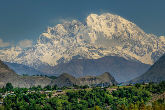
The white domes of Chitral Mosque point upward to the 25,289' summit of Tirich Mir, the highest mountain in Pakistan's Hindu Kush Range, some 50 miles in the distance.
Ric Ergenbright
5K notes
·
View notes
Text
Where is Chitral Valley Situated
Introduction
Nestled amidst the majestic peaks of the Hindu Kush range lies the breathtaking Chitral Valley, a gem of natural beauty and cultural richness. Situated in the northwest of Pakistan, this enchanting valley holds a significant place in both geographical and cultural realms. In this article delve into depth where is Chitral valley situated.
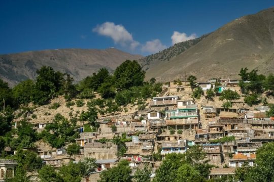
Image by Canva
Geographical Location
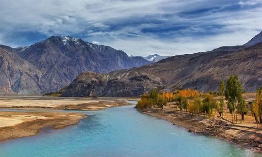
Chitral Valley is located at approximately 35.8510° N latitude and 71.7869° E longitude. It is surrounded by the towering mountains of the Hindu Kush range and shares borders with Afghanistan to the north and west, Gilgit-Baltistan to the east, and the Khyber Pakhtunkhwa province to the south.
Chitral Valley within Pakistan
Within Pakistan, Chitral Valley is part of the Khyber Pakhtunkhwa province. It is situated at a considerable distance from major cities like Islamabad and Peshawar, providing it with a remote and pristine allure.
Topography and Landscape
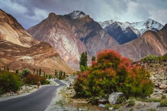
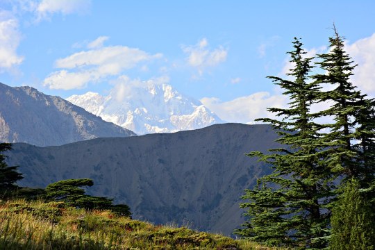
The topography of Chitral Valley is characterized by rugged mountain ranges, including Tirich Mir, the highest peak in the Hindu Kush. Several rivers, including the Chitral River and its tributaries, traverse the valley, creating picturesque valleys and fertile plains.
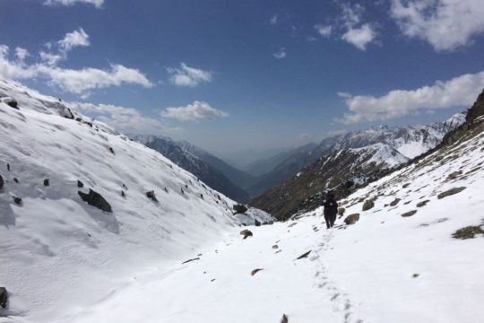
Image by Canva
Climate
Chitral Valley experiences diverse climatic conditions, with hot summers and cold winters. The region receives moderate to heavy snowfall during the winter months, while the summer season brings pleasant temperatures, making it an ideal destination for travelers.
Flora and Fauna
The valley boasts rich biodiversity, with a variety of flora and fauna inhabiting its diverse ecosystems. Endangered species such as the Marco Polo sheep and the snow leopard find sanctuary in the pristine wilderness of Chitral.
Cultural Significance
Chitral Valley is home to various indigenous communities, including the Kalash people, renowned for their unique culture and customs. Traditional festivals such as the Chilimjusht and Uchau showcase the vibrant heritage of the valley.
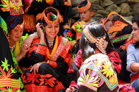
Image by Canva
Tourism in Chitral Valley
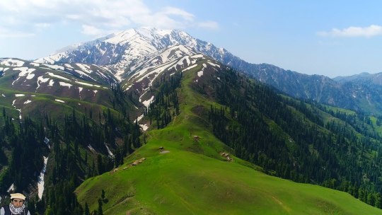
Tourism plays a vital role in the economy of Chitral Valley, attracting visitors with its stunning landscapes and cultural attractions. Adventure enthusiasts can indulge in activities like trekking, mountaineering, and river rafting amidst the breathtaking scenery.
Infrastructure and Accessibility
While Chitral Valley remains relatively remote, efforts have been made to improve infrastructure, including road networks and air travel options. The Lowari Tunnel provides year-round access to the valley, enhancing connectivity with the rest of the country.
Challenges and Conservation Efforts
Despite its natural beauty, Chitral Valley faces environmental threats such as deforestation and habitat loss. Conservation initiatives aim to preserve its pristine ecosystems while promoting sustainable development.
Economic Contributions
Agriculture and livestock rearing are the primary sources of livelihood for the inhabitants of Chitral Valley. Additionally, handicrafts and tourism contribute significantly to the local economy, providing employment opportunities for the residents.
Future Prospects
As Chitral Valley seeks to balance economic development with environmental conservation, sustainable development goals are prioritized. Efforts are underway to promote eco-tourism and preserve the valley's natural heritage for future generations.
https://youtu.be/IDeEG_ftGZk?si=D0Nlwh4bK1zztC18
Video by BrownBoyTravels YouTube Channel
Conclusion: Where is Chitral Valley Situated
In conclusion, Chitral Valley stands as a testament to the unparalleled beauty of Pakistan's northern regions. Its majestic landscapes, rich biodiversity, and vibrant culture make it a must-visit destination for travelers seeking adventure and tranquility amidst nature's splendor.
FAQs
1. Is Chitral Valley safe for tourists?
Yes, Chitral Valley is generally safe for tourists, with welcoming locals and stunning landscapes. However, it's advisable to respect local customs and travel advisories.
2. What is the best time to visit Chitral Valley?
The best time to visit Chitral Valley is during the summer months (May to September) when the weather is pleasant, and outdoor activities are in full swing.
3. Are there accommodations available in Chitral Valley?
Yes, Chitral Valley offers a range of accommodations, including hotels, guesthouses, and camping facilities, catering to various budgets and preferences.
4. What are some must-visit attractions in Chitral Valley?
Some must-visit attractions in Chitral Valley include Shandur Pass, Kalash Valley, and the Chitral Gol National Park, known for their scenic beauty and cultural significance.
5. How can I reach Chitral Valley from Islamabad?
The most convenient way to reach Chitral Valley from Islamabad is by air, with regular flights operating to Chitral Airport. Alternatively, you can travel by road via the picturesque Lowari Pass.
-
Read the full article
#ArethereaccommodationsavailableinChitralValley#chitral#chitralvalley#destination#explore#hiking#HowcanIreachChitralValleyfromIslamabad#IsChitralValleysafefortourists#pakistan#places#tourism#travel#Whataresomemust-visitattractionsinChitralValley#WhatisthebesttimetovisitChitralValley#whereischitralvalleysituated
0 notes
Text
pt8
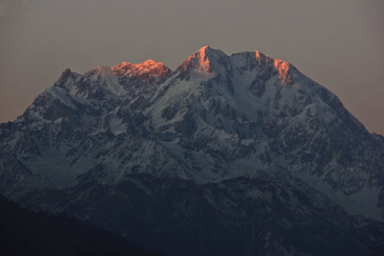
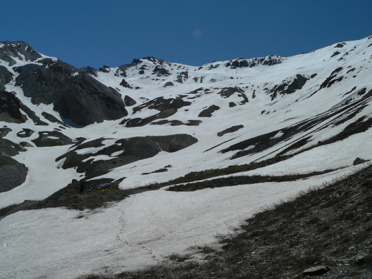
Tirich Mir:
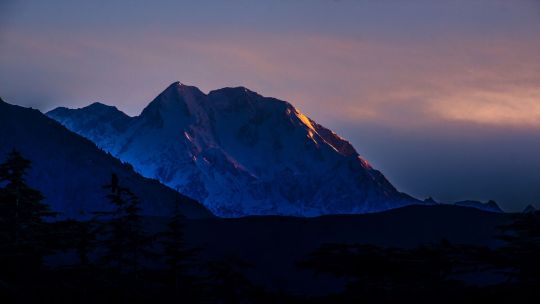
Tirich Mir is the highest mountain in the Hindu Kush range, located in Pakistan. It stands at an impressive height of 7,708 meters (25,289 feet). Tirich Mir is renowned for its stunning beauty and challenging terrain, attracting mountaineers and adventurers from around the world. The name "Tirich Mir" translates to "King of Darkness," possibly due to the shadow it casts over the surrounding landscape. Climbing Tirich Mir is considered a significant achievement in mountaineering, but it requires careful planning and technical skill due to its steep slopes and unpredictable weather conditions.
This mountain is once again a stunning work of nature, I think this picture really compliments it well and captures the diverse landscape that surrounds the mountain. Once again you can see the snow coming off of the peaks that I have observed with other mountains, I find it really adds a mystical vibe to the mountains that I love and find to be one of the most breath taking parts of this picture, as well as the lighting that I really am enjoying. The yellow light that is covering the mountain makes it look like it is glowing gold. I will aim to tweak my lighting to be something similar to this.
1 note
·
View note
Text
ترچ میر : کوہ ہندوکش کی بلند ترین چوٹی
ضلع چترال میں واقع ’’ترچ میر‘‘ سلسلہ کوہ ہندوکش کی بلند ترین چوٹی ہے۔ سلسلہ کوہ ہمالیہ و قراقرم سے باہر یہ دنیا کی سب سے اونچی چوٹی ہے۔ سطح سمندر سے اس کی بلندی 25289 فٹ ہے۔ اسے سب سے پہلے 21 جولائی 1950ء کو ناروے کے مہم جوؤں نے سر کیا۔ اس پہاڑی کو چترال کے بازار سے دیکھا جا سکتا ہے۔ ترچی میر کی جانب سفر کرتے ہوئے آخری گاؤں کا نام ترچی ہے۔ یہاں کے لوگوں کی زبان کھوار ہے۔ یہاں سرد ترین ماہ جنوری میں اوسط درجہ حرارت منفی 17.5 ہوتا ہے جبکہ گرم ترین دو ماہ یعنی جولائی اور اگست میں اوسط درجہ حرارت 6.5 سینٹی گریڈ ہوتا ہے۔
محمد اقبال
1 note
·
View note
Photo
The King Of Darkness - Tirich Mir (7,708 m), Hindu Kush, Pakistan.
Tirich Mir is the highest mountains outside Himalayas-Karakoram Range and the highest mountain in the Hindu Kush Range. It is believed the origin of the name Tirich Mir is "King of Tirich" as Tirich is the name of a side valley of the Mulkhow valley of Chitral which leads up to Tirich Mir. An alternative etymology derives its name from the Wakhi language. In Wakhi trich means shadow or darkness and mir means king so Tirich Mir means king of darkness. It could have got this name as it causes long shadows on the Wakhan side of its face.
(Source)
#pakistan#kpk#Khyber Pakhtunkhwa#hindu#kush#tirich mir#mountain#chitral#climbing#nature#landscape#travel#explore#tourism#iheartpakistan
146 notes
·
View notes
Text
What is the height of Tirich Mir peak?
What is the height of Tirich Mir peak?
What is the height of Tirich Mir peak?
A. 7690 meters
B. 7650 meters
C. 7670 meters
D. 7640 meters
Continue reading
View On WordPress
0 notes
Link
Tirich Mir (7708m)
#HifzaTravelGroup #HTG #NaranKaghanValley#TheAdventuresClubs #DomesticTours
0 notes
Photo
140) Khoshey people, Khoshey (Khowar: Khow, Chitrali: Khosh Yemeni) to plemię Kho mieszkające w Torkhow, Mulkhow, Laspur, Chitral, Drosh, Tirich Mir, Ayon, dystrykt Chitral w prowincji Khyber-Pakhtunkhwa w Pakistanie i Badakhshan. Khoshey mówią językiem Khowar.
1 note
·
View note
Text
PLACES THAT YOU MUST VISIT IN PAKISTAN
When you come to Pakistan, the country is blessed with exceptional and mesmeric landscapes, beautiful rivers, huge and wide desserts, calm lakes, tranquil waterfalls, exotic, huge and calm icy glaciers, and a few exciting awing sceneries. There's no doubt Pakistan the country is holy with each face and style of natural beauty.
Place 1: Chitral
When talking regarding the foremost favorite holidaymaker destination in an Asian country, Chitral continually tops the charts. At Chitral, there are several choices to explore like Tirich Mir; that is one in all the best mountain peaks within the range chain. There are many majestic mountains and lush inexperienced meadows that solely defines the spectacular landscape of Chitral valley.

There are several hotels and resorts within the valley that are giving mesmeric views of the geological formation. Garam Chashma could be a spot wherever each holidaymaker enjoys the foremost. The universal truth is that the water from Chashma is often cold however what makes Garam Chashma unbelievable is that it's a fountain that has miraculous healing properties in it moreover. Barmoghlasht could be a well-known resort in Chitral. within the summers, sightseers love paragliding whereas in winters they like sport. the 2 spots particularly Koghazi and Goleen have remarked as paradise on Earth thanks to their large beauty. These locations are simply fourteen kilometers far away from Chitral.
You can find several trees that are bearing fresh fruits, unbelievably amazing inexperienced meadows and exceptional landscapes in Chitral that creates it a prime priority once it involves traveling to northern areas of an Asian country.
if you are in Pakistan and you visit the Lahore city and face some problem related living place when you visit this link and I fix your problem for you houses for sale in DHA Lahore
Place 2: Neelum Valley
Nearly 240 kilometers long, the picturesque and scenic Neelum valley is placed at the north and also the northeast aspect of Muzaffarabad. It runs parallel to the attractive Kaghan valley that goes up to the Kel. it's separated from Kaghan depression by snowy peaks and blue water.

Neelum Valley could be a good spot for trekking with friends and family. The Ratti Gali Lake in Dowarian is not simply a hypnotic lake, however the engaging and quaint piece of heaven. Jagran Nallah is an exotic and entrancing place that joins Neelum valley and permits trout fishing. There are Kundal Shahi and Kutton that's one hundred fifty-five kilometers and sixteen kilometers far away from Neelum watercourse, that is additionally fascinating to go to.
At Neelum valley, the tourist's witnesses superb scenic beauty, exclusive perspective, on each side of the watercourse there are high hills, lush inexperienced flourishing forest, high altitude huge lakes and attractive surroundings that create the dream of beauty truth.
Spot 3: Hunza
A mountainous valley within the neighborhood of Gilgit is a neighborhood currently underneath Pakistan named as Hunza. it's the foremost notable traveler destination simply because of its classic beauty and natural beauty. it's normally called if there is any heaven on Earth than Hunza depression is that
The Hunza valley is amid range and also the range that's nearly a hundred klick from Gilgit. There are several beautiful spots to go to in Hunza like the historic Baltit Fort that's within the United Nations agency world heritage tentative list. The Borith Lake has some spectacular read, specifically in winter season once several ducks, moreover because the birds, migrate from different heat regions of Asian nation. there's the second highest peak within the world, K-2 that is ideal for trekking expeditions.
if you want to buy some property in Lahore then you must visit this site that is one of the most preferred choices for the people who are in search for a house for sale in DHA Lahore
Hunza is additionally notable for its beautiful eateries that provide the normal Sharbat, diram-fete, muleda, dildo and lots of different exotic ones. Hunza isn't simply stunning to travel and revel in the heavenly beauty however conjointly attractive to go to with favorite ones. it's a favorite spot particularly for new married couples to get pleasure from their golden amount of married life within the heat of incommensurable nature’s beauty.
Spot 4: Swat
Swat is that the district within the Malakand Division of the Khyber Pakhtunkhwa province. it's celebrated for its exceptional natural beauty and scenic landscapes. In 2007 the land of pure beauty was condemned by the Taliban and therefore the district lost its tourists importance. when the war against the act of terrorism in Swat by the military commandos in 2009, the land got free from criminal occupants and once more opened for tourists everywhere the planet.

There are several reasons to go to Swat once you come back to the Asian country. It offers astonishing views of the stream of Swat, ennobling Malamjabba resort hotel, Mingora, Kalam, Saidu Sharif, and Bahrain. All those tourists who are history aficionado than Swat could be a good spot with nice historic and fine arts worth. there's a recreational space named Fizagat Park that's not simply lovely however additionally has exciting views. Marghazar that's simply a number of miles off from Saidu Sharif could be a gorgeous white marble palace additionally called Sufed Mahal.
The celebrated Malala Yousafzai was additionally from the attractive valley of Swat. Swat holds utmost beauty awarded by Almighty and it's an ideal spot to get pleasure from some unforgettable moments with friends, family and your lover.
Spot 5: Kaghan Valley
A beautiful valley that's forever able to forge a wizardly spell on its spectators, Kaghan valley is an alpine-climate valley that's found within the district of Mansehra in KP (Khyber Pakhtunkhwa) province of West Pakistan. The mesmeric natural depression extends to just about a hundred and fifty-five kilometers beside a beautiful pine forest, tremendous mountain streams, and luxurious inexperienced meadows, creating it an awesome spot for tourists from everywhere in the country.

Naran and Balakot is a part of this glorious valley. Through Kaghan valley, Kunhar stream flows adding additional splendor and magnificence to the scenic space. Tourists visiting Kaghan valley can never miss the chance to ascertain Lake Saif-ul-Mulook that's a fascinating lake enclosed by verdure never seen before. The pointed peak, Malika Parbat may be seen as a mirrored image within the lovely crystal clear lake. A quaint inexperienced pasture named as Lalazar has thick dark forests of pine and fir with wildflowers growing everywhere the mountain slopes. House For Sale in DHA Lahore
Kaghan Valley could be a paradise that came on Earth. It offers splendid scenic views and beautiful landscapes that are beautiful to observe. The far-famed Jheel Saif-ul-Mulook and therefore the Lalazar is a number of the foremost picturesque places of West Pakistan to go to, particularly at the time of spring.
Spot 6: Gilgit Baltistan
The northern territory of West Pakistan is thought as Gilgit and Baltistan that is enclosed by marvelous and majestic tall mountain peaks. It borders with Azad Kashmir to the south, whereas borders Khyber Pakhtunkhwa to the west, Wakhan the passageway of Afghanistan to the aspect|side} and state region of China to the eastern side. it's stunning simply the method {kashmir|Kashmir|Cashmere|Jammu, and kashmir|geographical area|geographic area|geographical region|geographic region} is; as Kashmir is actually an area which may be compared to the wonder of Heaven higher than the sky.

The incomparable celebrated Yasin natural depression, Naltar and mountain peak are a part of} wonderful Gilgit and Baltistan and are part of the bucket list of each tourer visiting the place. This region as called in a veryll|one amongst|one in every of} the attractive places of West Pakistan that are not simply stunning however once you are there you are feeling like being in a paradise of solitude and eternal beauty. The inexperienced meadows are found at the bottom of Nanga Parbat and for hiking the durable Nanga Parbat, the tourist takes around four to five hours of continuous hiking to achieve the highest of it.
Spot 7: Rawlakot
The capital of Poonch district in Azad Cashmere, Rawalakot could be a lovely spot for tourists everywhere on the planet. it's additionally stated as ‘Valley of Pearls’ as a result of within the summers the almond trees blossom giving an overall impression of pearls being scattered on the bottom.

A noted peak space of Rawalakot is Tolipir that is at a pair of hours’ drive from Rawalakot. For honeymoon tours, this pristine beauty place in conjunction with hypnotic landscapes builds it a perfect spot for young couples.
Spot 8: Shogran And Siri Paye
Shogran and Siri PAYE are 2 tourists spots settled within the Kaghan valley, that are somewhat underrated as compared to different places in West Pakistan. Shogran maybe a hill station that has lots of resorts likewise as hotels for accommodation of the tourists. Whereas, Siri PAYE may be a high mountain lake encircled by undulating clouds, nearly eight kilometers far from Shogran.
Both these places don't seem to be simply stunning however conjointly offers exotic landscapes, lush inexperienced grassland, and picture scenic read to treasure each moment of life with delight and happiness. House For Sale in DHA Lahore
This is the list of most stunning places that as a tourer you have to be compelled to visit. Update your bucket list directly expertise|and knowledge|and skill} the heavenly experience right Earth in West Pakistan. At ilaan.com we tend to carry on posting tourists guide for you to understand a lot of regarding exceptional places everywhere West Pakistan. keep tuned for contemporary updates.
1 note
·
View note
Text
Tirich Mir
Tirich Mir
Tirich Mir (Tirich Mir, Tirich Mir) is a mountain near Chitral in Pakistan, the highest mountain in the Hindu Kush range. At 7,708 meters (25,289 ft) high, the Himalayas - Karkoram is the highest mountain outside the class and the 33rd highest in the world (the other 32nd Himalayas - located in Korkoram). The town of Chitral is home to Tirich Mir, but the mountain is so large that it borders some parts of Pakistan on the other side of Pakistan.
Origin of the name--
The word "mir" means "king" or "master." There are two types of ideas in the full name of Tirich Mir. The first is that it has a small plaintiff named Chitral in Chitra, which may mean "king of the plumage". The second possibility is that the name is derived from the "Bakhi language" which means "shade", meaning the full name means "king of the shade". The long shadows of this mountain fall in the case of Bakhan.
The first climb--
It was first climbed to the top of the Tirich Mir in the 1950s by a young mountaineer from Norway. People in the area believe that the hill is inhabited by demons, right-wingers and fairies who are a threat to climbers. In fact, people who come here every year wander around and die. Often falling to the ground they could not find their bodies. वास्तव में भी हर साल साल आये आये कुछ इसकी ढलानों ढलानों पर चढ़ते चढ़ते चढ़ते मारे जाते जाते. अक्सर यह गहरी खाईयों खाईयों में गिर हैं हैं और इनके शरीर नहीं नहीं.
0 notes
Text
Trich Mir (Main) at 7,708m is the highest peak of the Hindu Kush Range. Trich Mir main Peak was climbed first time in 1950 by a Norwegian Expedition,which was led by Arne Naess. The other members of the expedition included P. Kvernberg and H. Berg Trich Mire East; its altitude is 7692m and was climbed in 1964 by a Norwegian Expedition which was also escorted by Arne Naess. Two members, R. Hoibakk and A. Opdal reached top of Trich Mir (East) Trich Mir West, It is 7500m,high, and was climbed in 1974 by Beppe Re and Guido Machetto an Italian expedition. Tirich Mir like Rakaposhi and Nanga Parbat to the east, is known for being the home of 'Peris' called "fairies" in English.
Baltistan Adventure is an experienced organization in handling Expedition in karakoram, Trekking in karakoram, Adventure tours, Biking, Jeep safaries and Cultural Tours in the Karakoram of Gilgit Baltistan Pakistan and most popular are K2 Base camp via Gondogoro La trek, K2 Base camp and Concordia Trek, Adventure in K2 Base Camp.
#BaltistanAdventure#BaltistanAdventureTours#TrekkingInKarakoram#ExpeditionInKarakoram#K2BaseCampAndGondogoroLaTrek#K2BaseCampConcordiaTrek#AdventureInK2BaseCamp#Nature#Beauty#Pakistan#GilgitBaltistan#Skardu#Hunza
1 note
·
View note
Text
New Post has been published on Trekking in Pakistan
New Post has been published on http://bit.ly/2tZcBJb
Owir An
Duration 3 days Distance 15.7km Standard moderate Season mid-June-mid-September Start Shahguch Finish Mujhen Zone and permit Open, no permit Public Transport Yes Summary This popular and easily accessible trek crosses a ridge- top pass along the southern flanks of mighty Tirich Mir, visiting friendly villages along the way.
Crossing the Owir An (4337m) is a short and popular trek that offers wonderful close- up views of the southern flanks of the Tirich Mir massif. The description that follows is from Ojhor, south- west of Tirich Mir, to Owir, south- east of Tirich Mir, but it can be done in the reverse direction.
Planning
Maps and Books
The topographic US AMS 1: 250, 000 map Mastuj (NJ 43-13) and 1:253, 400 map Zebak (j-42 x) cover the trek. They don’t label Lasht in Ojhor, or Mujhen along the Owir Gol’s true left bank across from Shungush. Riri is labeled as Reri.
Tirich Mir: The Norwegian Himalaya expedition by Aarne Naess et a1 is the story of the first ascent of Tirich Mir (hardcover).
Guides and porters
The trail over the pass isn’t hard to find, so a guide is optional. Ojhor porters, who work between Kiyar or Lasht and the first village in Owir, ask for a flat rate per day, including payment for food rations. When going up the north Barum Glacier to Tirich Mir Base Camp, hire Owir porters from Shahbronz.
Getting TO/From THE TREK
To the Start
Jeeps depart from Chitral’s Ojhor sarai (stopping place) behind hotel Dreamland to Sussoom and Kiyar (two hours, 30km). Special hires. The first 20km (45 minutes) is along the sealed road to Garam Chashma and the bridge at Shoghor. The last 10km (1¼ hours) is a steep ride up a narrow jeep road.
From the Finish
Mujhen- Chitral or Shahbronz- Chitral jeeps or Special hires. If no jeeps are in Mujhen, walk 4.8km on a trail across barren land to Riri and look for one there. Riri- Chitral jeeps. You can also keep walking on the road 3.2km beyond Riri to Parpish and the bridge over the Mastuj River to the Chitral- Gilgit road. Parpish-Chitral jeeps. A seat in a Buni- Chitral van. When doing this trek in the reverse direction, jeeps to Riri, Mujhen and Shahbronz depart from Chitral’s Owir sarai next to the Allied Bank, across the street from the Al- Farooq Hotel, in Naya Bazaar. The proprietor of a teashop in the corner of the sarai can help you get on a jeep. Jeeps to Mujhen and Shahbronz use a newer bridge 3km north of the Parpish Bridge.
The Trek
Day 1 : Shahguch to kiyar High camp
2- 2½ hours, 4km, 330m ascent
Ojhor Gol separates Sussoom (2896m) and kiyar villages. Along its true right bank is Lasht. Shahguch, a large well- watered grassy area, lies between the two villages just upstream from the bridge. Camp in Shahguch (3000m) before ascending farther. From Shahguch, follow the road 15 minutes to kiyar. From kiyar’s polo field, head left and follow a trail up through fields. keep the obvious dry rocky spur with a small cairn on it to your left and head for the highest trees and fields. On your right, but farther away, are three vertical rock outcrops, and a waterfall upvalley from them. Reach the highest fields and houses and continue on a trail to the saddle crossing the dry rocky spur on your left, one hour from Kiyar.
This vantage point has a superb view of Tirich Mir and upper Ojhor Gol. From the saddle, contour gently up the Ojhor Gol’s east side 45 minutes to one hour, crossing several small clear streams, to Kiyar High camp (3500m), a sheltered level grassy area with room for many tents.
Day 2 : Kiyar High Camp to Owir High Camp
4- 4½ hours, 4.7km, 837m ascent, 150m descent
The trail reaches a ridge in 15 minutes and turns east to head up the south side of the valley leading towards the pass. Contour around 30 minutes to the snow pack at the confluence of two small streams. The ascent to the Owir An is up the north (left) side of the rocky bluffs above. From the snowfield, ascend to the gully with a small stream, left of the rocky outcrop, in 30 minutes. From here, it’s a steep one- to 1½ hour climb to the pass itself. A small black outcrop lies just left of Owir An (4337m). In heavy snow years, or early in the season, a snowfield lies on both sides of the pass. From the pass, the Buni Zom massif dominates the view with Shandur range stretching to the distant horizon. The fields of Shungush are visible below.
Descend along the small stream, crossing another small side stream from the left. The trail descends a ridge, well above the main stream’s true left side. One hour from the pass, reach a level area with some grass and a few tent sites where two streams meet. This is where the alternative trail to the Barum Glacier starts (see the alternative Finish).
Alternative Finish : Kiyar High Camp to Shahbronz
This route takes as you to Shukushal, and gives you the option to continue to Tirich Mir Base Camp.
If trekking in the reserve direction, ascending to the pass from Owir High Camp, follow the ridge trail up steeply. The pass isn’t visible until you reach the ridge top, above the true left bank of the stream below. As the trail and the stream near each other, a small hill is visible ahead with a prominent squared- off rock outcrop to its south (left). The Owir An lies just to the north of this hill.
To continue towards Mujhen, follow the Trail that crosses to the main stream’s true right bank, and continues across rolling hills and grassland 45 minutes to another stream and a large grassy area. Large Owir High Camp (4178m) is near a small pool at the base of a rock outcrop.
Day 3 : Owir high Camp to Mujhen
2-2 ½ hours, 7km, 1260m descent
Cross to the stream’s east side and follow an abandoned canal. The trail contours around several ridges and as you leave camp you can see the square- topped outcrop and small hill that mark Owir An. The view up to Tirich Mir is impressive. Contour to a ridge overlooking fields and houses, then descend to the upper settlement, one hour from the High camp. Follow the large trail through the village one hour to Mujhen (2927m).
Alternative Finish : Kiyar High Camp to Shahbronz
This route takes as you to Shukushal, and gives you the option to continue to Tirich Mir Base Camp.
Alternative day 2 : Kiyar to High Camp to Gologari
4 hours, 4.7km, 837m ascent, 137m descent
From the level grassy area with a few tent sites one hour below (east of) the pass, follow a trail along the main stream’s true left bank 30 minutes ahead to the grassy area called Gologari (4200m).
Alternative day 3 : Gologari to Shahbronz
4 hours, 9km, 1200m descent
Continue to Shahbronz (3000m), where you change porters.
Alternative day 4 : Shahbronz to Shukushal
6 hours, 10km, 800m ascent
Shukushal (3800m), the local name for Tirich Mir Base Camp, is six hours up the Barum Gol, near the North Barum Glacier’s terminus.
Side Trip : Tirich Mir Base Camp
4 days, 30km, 900m ascent, 900m descent
Two Days beyond Shukushal, up the Barum Glacier, is another base camp (4700m), which was used by the 1950 Norwegian expedition, the first to summit Tirich Mir.
Alternative Day 5 : Shukushal to Shahbronz
4- 5 hours, 10km, 800m descent
Return downvalley to the roadhead at Shahbronz.
0 notes
Text
The Hindu Kush
The Hindu Kush is an 800 km (500 mi) long mountain range that stretches between central Afghanistan and northern Pakistan. The highest point in the Hindu Kush is Tirich Mir (7,708 m or 25,289 ft) in Chitral District of Khyber Pakhtunkhwa, Pakistan.
The mountains have historical significance in the Indian subcontinent and China. There has been a military presence in the mountains since the time of Darius the Great. The Great Game of the 19th century often involved military, intelligence and/or espionage personnel from both the Russian and British Empires operating in areas of the Hindu Kush. The Hindu Kush were considered, informally, the dividing line between Russian and British areas of influence in Afghanistan. During the Cold War the mountains again became militarized, especially during the 1980s when Soviet forces and their Afghan allies fought the mujahideen. After the Soviet withdrawal, Afghan warlords fought each other and later the Taliban and the Northern Alliance and others fought in and around the mountains.
The American and ISAF campaign against Al Qaeda and their Taliban allies has once again resulted in a major military presence in the Hindu Kush. Alexander the Great explored the Afghan areas between Bactria and the Indus River after his conquest of the Achaemenid Empire in 330 BC. It became part of the Seleucid Empire before falling to the Indian Maurya Empire around 305 BC. Alexander took these away from the Persians and established settlements of his own, but Seleucus Nicator gave them to Sandrocottus (Chandragupta), upon terms of intermarriage and of receiving in exchange 500 elephants.
—Strabo, 64 BC–24 AD
Indo-Scythians expelled the Indo-Greeks by the mid 1st century BC, but lost the area to the Kushan Empire about 100 years later. Before the Christian era, and afterwards, there was an intimate connection between the Kabul Valley and India. All the passes of the Hindu-Kush descend into that valley; and travellers from the north as soon as they crossed the watershed, found a civilization and religion, the same as that much prevailed in India. The great range was the boundary in those days and barrier that was at time impassable. Hindu-Kuh--the mountain of Hind--was similarly derived.
Pre-Islamic populations of the Hindu Kush included Shins, Yeshkun, Chiliss, Neemchas Koli, Palus, Gaware, Yeshkuns, Krammins, Indo-Scythians, Bactrian Greeks, Kushans.
0 notes
Photo
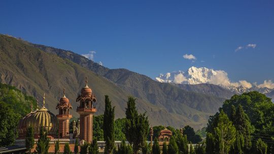
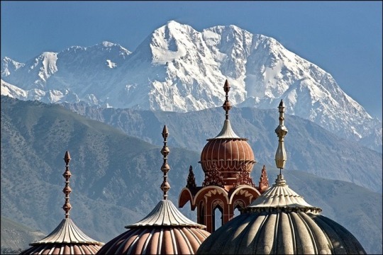
Shahi Masjid and Tirich Mir (7,708 m) , Chitral, Pakistan.
(Source)
#pakistan#kpk#Khyber Pakhtunkhwa#chitral#shahi#masjid#mosque#islam#islamic#Architecture#tirich#mir#mountain#nature#travel#explore#tourism#iheartpakistan
151 notes
·
View notes
Text
The highest peak of Hindu Kush range is
The highest peak of Hindu Kush range is
The highest peak of Hindu Kush range is
A. Tirich Mir
B. Nanga Parbat
C. K-2
D. Rakaposhi
Continue reading
View On WordPress
0 notes
Last Seen Blogs