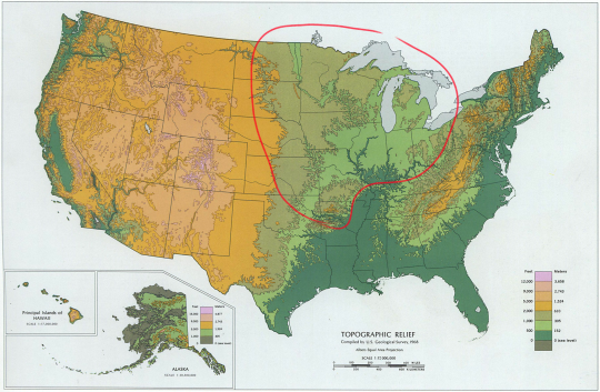
#Appalachian Plateau
Video
flickr
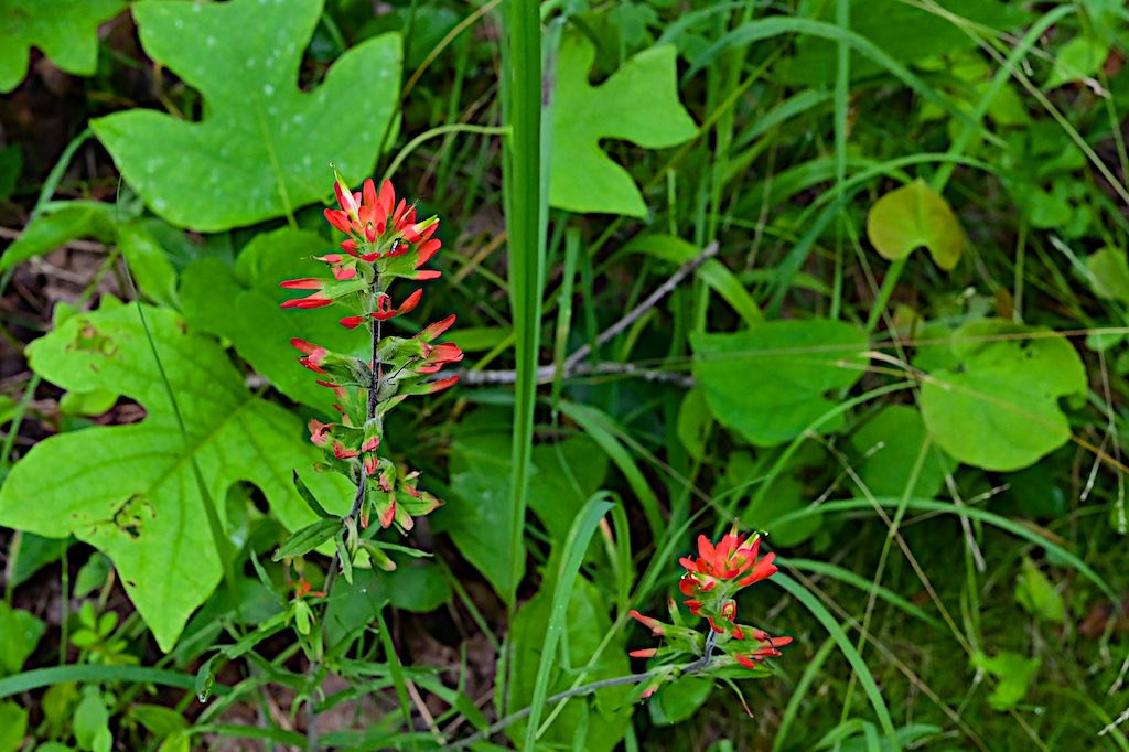
Indian Paint Brush at Lynx Prairie Preserve by durand clark
Via Flickr:
Found this wildflower at this Appalachian Plateau prairie after an easy but humid hike. Got some chigger bites and found one deer tick on my leg, just roaming. The bugs, heat and humidity brought my hiking to a temporary halt.
#indian paintbrush#wildflower#e lucy braun lynx prairie#edge of appalachia preserve#hiking#adams county ohio#appalachian plateau#prairie#nikon digital#nikon mirrorless#nikon z6#nikon 40mm f/2#prairie-fire#castilleja#orobanchaceae#nature#nature preserve#the nature conservancy#cincinnati museum center#flickr
1 note
·
View note
Video
Under the New River Gorge Bridge (New River Gorge National Park & Preserve) by Mark Stevens
Via Flickr:
A view looking to the west across the New River Gorge while standing just out from underneath the namesake bridge. My thinking in composing this image was to have that view looking across and underneath the bridge itself with its intricate structures present. I went with a more leveled-on look across the setting as I felt the angle helped to maximize the arch and other structures of the bridge. While it would have been nice to have had sunny, blue skies that afternoon, the overcast skies did helps to mute the brightness present and allow me to focus more on the bridge. I later worked with control points in DxO PhotoLab 4 and then made some adjustments to bring out the contrast, saturation and brightness I wanted for the final image.
#Allegheny Mountains#Appalachian Mountains#Appalachian Plateaus#Arch Bridge#Azimuth 257#Bridge#Bridge Structure#Cloudy#Day 2#DxO PhotoLab 4 Edited#Forest#Forest Landscape#Hillside of Trees#Landscape#Landscape - Scenery#Looking Up#Looking West#Looking up at Sky#Mostly Cloudy#Nature#New River Gorge#New River Gorge Bridge#New River Gorge National Park & Preserve#New River Gorge National Park and Preserve#New River Gorge and Indiana Dunes National Parks#Nikon D850#No People#Outside#Overcast#Portfolio
2 notes
·
View notes
Video
Upper Piney Falls by Jason Parker
#Appalachia#Appalachians#Cumberland Plateau#Cumberland Trail#East Tennessee#Little Piney Creek#Piney Falls Loop#Piney Falls Trail#Rhea County#Spring City#Tennessee#Walden Ridge#landscape#natural beauty#naturen#outdoor#scenic#winter#waterfall#Upper Piney Falls#enn#flickr
0 notes
Text
florida + prairies + deserts = the world is flat and you can see shit coming for miles
florida + east coast + west coast = the world is water and you can see shit coming for miles
appalachian mountains + pacific coast ranges + colorado plateau = the world is layered and glacial and you can see shit coming for ages
new england woods + pacific northwest forests = the world is layered and you cannot see what’s coming. but when the birds go quiet you can feel it
135 notes
·
View notes
Photo
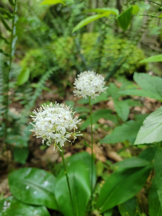
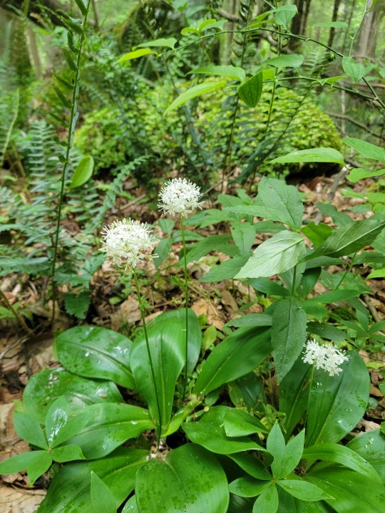

Clintonia umbellulata Limited to Appalachian mountains, Allegheny Plateau, and the Ilp in mixed mesophytic forests
pretty sure when these bloom I feel like forest spirits are near by, get chills every time.
128 notes
·
View notes
Text
Loyal citizens of the Commonwealth of Virginia, I must know:
7 notes
·
View notes
Note
Everything roughly north of the Arkansas river and Mississippi Delta/River Valley, East of the Rocky Mountain Plateaus, and West of the Appalachian foothills
This is probably the largest possible map I will still accept
35 notes
·
View notes
Text
So as it turns out, Plato was very consistent about the geomorphology of Atlantis
A lot has been said about Atlantis, but not much attention is paid to what that island actually was. It's a shame everybody talks about aliens but not igneous rocks :(
In the original text, called Critias, amongst the description of this perfect society placed there by the hand of Neptune and swallowed by the sea as punishment for their hubris, there is a surprising amount of detail about the morphology of Atlantis, especially its geology.
In terms of size, it is said the Island is bigger than Libya and Asia. These names are the ancient equivalents of the modern regions we call north Africa and the near east (roughly between the eastern shore of the Aegean and Persia). The measurements that are given concretely are given in stadia. The size of this measurement changes based on the time and place, but I'll use attic stadia since that's where Critias was from, it's equivalent to 177.6 meters. Attica is the region of Greece where Athens is, northeast of the Peloponnese peninsula. The distance between the center of the island and the sea is 335km, equivalent to about 2 Corsicas' length.
It is "beyond Heracles' pillars", which means the strait of Gibraltar, the limit of westwards Greek geographical knowledge. The civilization that lived in the island was centered on rectangular shaped plains, surrounded by mountains and, at its center, lay a moderately sized hill. The entire island is raised considerably off the sea, so its shores were like cliffs. The climate is implied to be subtropical, somewhat warm, and with plentiful rain in the winter but not that much in the summer.
Regarding the metals, I'll try to summarize as much as I can because it's kind of a lot. The main resource present at Atlantis is orichalcum, we don't know for certain what it was, but it's generally accepted that it was a zinc-copper alloy, almost as valued as gold because of its long lasting shine. Plato says this alloy was extracted directly from the island, but for simplicity's sake I chose to interpret it as copper and zinc being very abundant. The other metals which are mentioned are bronze, tin, gold, and silver. Plato doesn't go into nearly much detail about the rocks they used, and only says white and black rocks. This, as you'll see, isn't that bad of a hint.
My first instinct about the morphology of this place was a plateau whose center was eroded away, leaving a bowl-like shape, where the edges of the original plateau act as mountains. This would even explain the lower mountain in the middle, as it would be an almost fully eroded mesa, left from the original plateau

However, the mountains are described as tall and impressive, which isn't exactly what this is.
So, my second thought was the alpine orogeny. This was a generalized increase in the frequency and force of tectonic shifts, which makes up the tertiary geological era. This was the origin of the highest and youngest mountain ranges in the world. From the Pyrenees, through the Alps, Carpathians, Caucasus, Alborz and to the Himalayas, there is an almost unbroken chain of mountain ranges formed at the same (geological) time. These mountain ranges generally have dramatic changes in incline, compared to older ones like the Urals or Appalachians. And most importantly, this violent tectonic activity usually also includes a lot of volcanic activity, where our favorite igneous rocks form by cooling down by coming into contact with the crust's rocks, the air, or water.
Now it turns interesting. Copper is mainly found within igneous rocks, mostly granites (granite is a lot of colors but one of them is white) during subduction of the tectonic plates. Copper also forms when hydrothermal fluids cool down. It can be formed through sedimentary means, but in less abundance and not particularly relevant to our case. Zinc, however, only forms when ocean water interacts with hydrothermal fluids, in what's known as sedimentary exhalative deposits. When this happens, zinc associates with sedimentary rocks such as LIMESTONE and DARK LUTITES. These are white and black rocks.
Just from these two metals we can intuit that Atlantis used to be half-submerged in the ocean and then rose above sea levels. Also, the hydrothermal vents suggest it's near the border between tectonic plates, where the mantle escapes more often into the crust. But we aren't done with metals
Tin is found primarily within cassiterite, an igneous mineral which crystalizes near hydrothermal vents and inside gneiss and GRANITE. Silver is also commonly formed from hydrothermal fluids. And when it's not, it's formed in magmatic processes alongside COPPER AND ZINC. And if that's not enough, silver also forms sedimentary inside LIMESTONE and LUTITES. Last of all, gold. Do you know how 80% of gold in the Earth formed? When there is an especially violent seismic shift in the earth, whether because of earthquakes or orogenesis, some cavities form inside the crust, where there is a sudden drop in pressure, and if there are certain fluids in these cavities, they will almost instantaneously sublimate into a gas, which then crystalizes into quartz veins that are also filled with gold deposits.

are you seeing this.
And this is not all. With what little detail we are given about the climate of Atlantis, we can figure out if it's in the north or south Atlantic. Let's look at some climographs.
First, the south Atlantic, take the island of Saint Helena as an example. This graph shows the average temperatures and precipitation in a given location throughout (typically) 50 years, broken down by months.
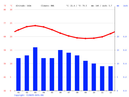
Its rains are very consistent, but extremely scarce, averaging around 10mm per month. And actually, according to Wladimir Köppen's classification, Bwh, it is a desert-like, subtropical climate. Not really what Atlantis is like.
For the north Atlantic, let's look at the Azores, an archipelago.
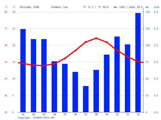
This is more like it. Abundant rains in the winter, almost reaching 150mm in December (more than what Saint Helena gets in a year). It's still fairly warm, and the summers are drier. Köppen classifies this as Csa.
And it just would so happen that the Atlantic ocean has a ridge running along its length, where the Eurasian and north American plates meet. It is very seismically and magmatically active, has plenty of hydrothermal vents, and has been constantly bringing out new rocks from the mantle ever since Pangea broke up and Afro-Eurasia drifted away from the Americas. Here is a very exaggerated render of what it looks like

You can see the Azores here, they are just east of the ridge, at the same latitude of southern Portugal.
Anyhow, so after looking at all of this, we can reconstruct roughly how the island of Atlantis formed:
Before the alpine orogenesis, a volcano erupted near the mid-Atlantic ridge. This brought out a lot of volcanic rocks, such as basalt. Some of them over sea level, but most of it under the sea. In this time, hydrothermal fluids rich in silver, zinc, tin and copper, are deposited on top of this new platform. When the alpine orogenesis begins to create massive mountain ranges across Eurasia, the platform created by the volcano is lifted upwards, creating a plateau surrounded by mountain ranges, and in the middle of the island, what's left of the old volcano gets gradually eroded away into a tall hill. This massive tectonic shift pushed many igneous rocks near the surface, such as granites, basalt, gneiss, and rhyolite. Either because of this push, or due to a later earthquake, a lot of quartz-gold veins are formed within the new island. Finally, erosion and sedimentation by the newly-formed rivers eventually turned the hydrothermal materials into limestone and lutite.
Ok so this is all fiction, and there is no lost island the size of north Africa in the north Atlantic. But isn't it really surprising that, in a metaphor about over-expenditure in the military, Plato described such a geomorphologically coherent continent? That basically all of the metals that were in abundance in Atlantis could all be created by the same couple of processes?
#köppen my beloved#this is a rant version of an essay for class#hope this is coherent because I am not reading all of that again#geography#geomorphology#atlantis#i have 34 tabs open lol
7 notes
·
View notes
Text
The blog is in queue......the Appalachian Glacier plateau 🏞️🌳🌲 is calling my name. Family reunion next wknd & food plots prep this wk for 🦌🏹!! Time to disconnect & reconnect with mother nature's beauty & the family.
What have I learned on this long vacation/work detail?!....I love mother nature, I enjoy watching every insect to every animal enjoying it's habitat and not being bothered by man.
I love my family even more as we age and watch the Youngins learn and grow as individuals. Passing on knowledge as well as learning.
What I don't like is people knowing damn well they're trespassing and don't give a fuck until two things happen. The land owner & their relatives have you at 2a point & leo's along with Wardens is involved arresting & fining said trespassers with multiple neighbors filing charges. Security has been updated as has awareness of all neighboring property owners see something 2 way radio, call, text, they all have them on all there for one another. Truly love the farmers and land owners that respect one another.
Few days left, work hired 2 employees to help while I'm gone, and both have been sent back to their agencies. The Owner has begged me to come home early, I told him not enough money in the world to replace the time with family and nature see you on the 21st.
To those who have read all, you're my kind of people 💜🫂 You have my love, respect, I wish upon you a healthy life and fortunes to help you and your families through to the next generations.
10 notes
·
View notes
Text
Old pictures
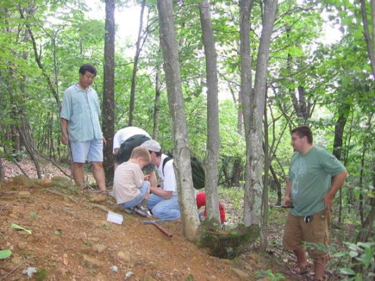
Oh, man looking at old pictures can be so emotional. Years ago we invited a professor from the college and a couple other sciency folks (and their kids) to have a fossil hunt here at the farm. Everybody dug through the shale for a while, then dragged their finds back to the house and got a lecture about what we’d found.
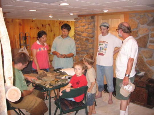
Then the kids got to run hogwild outside with the hose, to knock some of the dirt off themselves. One of the moms was originally from an area where water-use is very tightly controlled, and she got pretty upset about the kids enjoying the hose. I tried to reassure her it was ok, but she never really bought it. Having little kids - good times.
In our area the only fossils are smallish marine life, lots of bivalves, snails, crinoids and such. Just a bit west on the Appalachian plateau, you can find tree fern fossils. Near (naturally) all the coal mines.
9 notes
·
View notes
Video

flickr
Burial Ceremony on the Appalachian Plateau by durand clark
Via Flickr:
Harmon-salt Creek Church site of the service at Duke in rural Scioto County, Ohio.
2 notes
·
View notes
Video
flickr
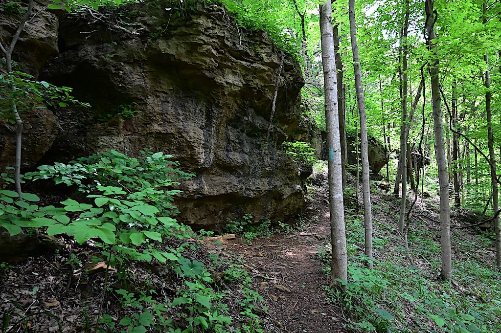
Rimrock by durand clark
Via Flickr:
Dolomite formation as I approach the overlook of the Appalachian Plateau on the Joan Jones Portman Trail. Part of the trail system of the Edge of Appalachia Preserve.
#edge of appalachia preserve#joan jones portman trail#appalachian plateau#adams county ohio#rimrock#dolomite#rocks#cliff#trail#hiking#southern ohio#appalachia#nikon digital#nikon mirrorless#nikon z6#nikon z 24-200 vr#flickr
1 note
·
View note
Video
Nature Comfort (New River Gorge National Park) by Mark Stevens
Via Flickr:
While standing on a wooden bridge with a view looking upstream and west to some waterfalls of the New River in the Sandstone Falls part of the national park. My thinking in composing the image was to use the river flowing by as a leading line into the image with the waterfalls in the center. Nearby and kind of framing the setting would be the colorful tree leaves. By angling my Nikon SLR camera slightly downward, I was able to create a more sweeping view with the river and also minimize the more overcast skies above that morning.
#Allegheny Mountains#Appalachian Mountains#Appalachian Plateaus#Azimuth 274#Cloudy#Day 2#DxO PhotoLab 4 Edited#Fallen Trees#Fallen Trees in River#Falls#Forest#Forest Landscape#Hillside of Trees#Landscape#Landscape - Scenery#Looking West#Mostly Cloudy#Mountains#Mountains in Distance#Mountains off in Distance#Mountainside#Nature#New River#New River Gorge National Park & Preserve#New River Gorge National Park and Preserve#New River Gorge and Indiana Dunes National Parks#Nikon D850#No People#Outside#Overcast
2 notes
·
View notes
Text
Geo-Cultural Groups
Europe:
-Caucasian: mountains
-Sarmatic Plains: Swamps, woodlands, plains, and small Vikings élite
-Balkanatolia: heartland of Hellenic civilization
-Italic: (North) City States & Germandom, (Mid) Papal states, (South) Byzantine and Norman Polities with Islamic influence
-Iberian:
-Nordic:
-Variscidia: Aside from the Papal states, Variscidia was the heartland of catholic powers during the early middle ages. It’s cultural background was a syncretism between Latin and Germanic traditions. Variscidia was the region of Europe that served as a bulwark against northern pagan Europeans, Eastern-Oriental Christendom, and Islamic expansion.
-British Isles:
-Visigrad: Transitionary phase into western Europe, Catholicism, Slavs and Steppe peoples (mongols, avars, gepids and magyars)
Asia:
East Asia:
-Tibetan Plateau:
- Northern River Basins:
-Southern River basin
- Goguryeo Mountain Enclosure:
-Mongolian Steppe
-East Asian Desert Complex
-Japanese Archipelago:
North Asia:
-Siberian Plateau (Eastern Mountain Complex, Central Mountain Complex)
-Siberian Plain
-Kolyma
-Yakutsk Basin
-Central Asian Desert Complex (West Asian Mountain Complex Included)
Southeast Asia:
-Indochinese Peninsula
-Malay Archipelago
Indosphere:
-Deccan Polities:
-Indo-Gangetic Polities:
Oceania:
-Polynesia
-Micronesia
-Melanesia
Middle East:
-Levant:
-Arabian Peninsula:
-Mesopotamia:
-Iranian Plateau:
Africa:
-Sahelian Kingdoms: Muslim & Sahelian, mounted warfare
-Guinean Kingdoms: Forested & Folk Religions
-Nile Kingdoms: Egypt, Nubia, axum
-Maghreb:
-Kongo Kingdoms:
-Lake Kingdoms:
-Kalahari Plateau:
-Swahili City States:
North America:
Appalachian Woodlands: Iroquoise & Algonquian, wooded, Haudenosaunee, long houses
Great Lakes:
Mississippian Ideological Interaction Sphere: Chimakuan, woodlands, mound builders, south east,
Great Plains:
Great Basin: aztec tanoan, "Desert Archaic" or more simply "The Desert Culture" refers to the culture of the Great Basin tribes. This culture is characterized by the need for mobility to take advantage of seasonally available food supplies. The use of pottery was rare due to its weight, but intricate baskets were woven for containing water, cooking food, winnowing grass seeds and storage—including the storage of pine nuts, a Paiute-Shoshone staple. Heavy items such as metates would be cached rather than carried from foraging area to foraging area. Agriculture was not practiced within the Great Basin itself, although it was practiced in adjacent areas (modern agriculture in the Great Basin requires either large mountain reservoirs or deep artesian wells). Likewise, the Great Basin tribes had no permanent settlements, although winter villages might be revisited winter after winter by the same group of families. In the summer, the largest group was usually the nuclear family due to the low density of food supplies.
Oasisamerica: Pueblo, cities, agrarian
Plateau:
Californian: The Pauma Complex is a prehistoric archaeological pattern among indigenous peoples of California, initially defined by Delbert L. True in northern San Diego County, California.The complex is dated generally to the middle Holocene period. This makes it locally the successor to the San Dieguito complex, predecessor to the late prehistoric San Luis Rey Complex, and contemporary with the La Jolla complex on the San Diego County coast.
Northwest Coast:
Arctic:
Subarctic:
Mesoamerica:
South America:
Andes:
Amazon:
Plains:
Australia:
Blaze
0 notes
0 notes
Text
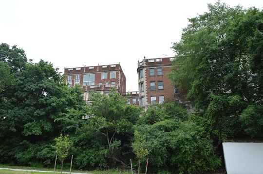

Cedar Glen Apartments
11424-11432 Cedar Glen Parkway
Cleveland, OH
The Cedar Glen Apartments, 11424-11432 Cedar Glen Parkway in Cleveland, Ohio, is a historic Georgian Revival luxury apartment building located on a bluff overlooking Cedar Glen Parkway in the University Circle neighborhood of Cleveland, Ohio. Designed by prominent local architect Samuel H. Weis and completed in 1927, the building originally contained luxury apartments and served as a gateway to the more exclusive neighborhood of Cleveland Heights, on whose border the building is located.
The city of Cleveland lies on the shore of Lake Erie on the Erie Plain. Just a few miles inland is the Portage Escarpment, which separates the Erie Plain from the Appalachian Plateau. The Portage Escarpment also defines the political geography of Cleveland and its eastern suburbs, and acts as both the legal and natural boundary between Cleveland and the city of Cleveland Heights, Ohio. In part, two ravines provided natural access to the heights atop the escarpment. One was the Doan Brook ravine, which today is encompassed by Ambler Park. The other was commonly referred to as Cedar Glen. From the beginning of white settlement of the area until about 1890, the area atop the escarpment (which would later become East Cleveland Township in 1847 and Cleveland Heights in 1901) was only very sparsely settled. Scattered on the edge of the escarpment were dairies, farms, orchards, and vineyards in Cedar Glen.
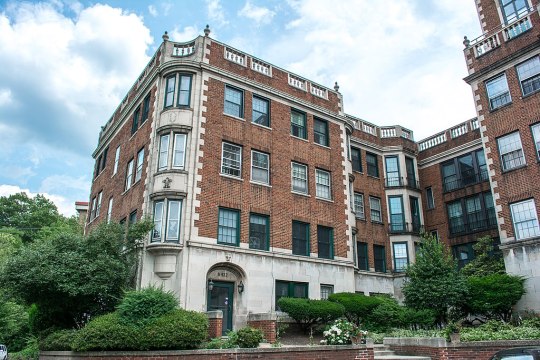
Despite the extensive development on the east (Cleveland Heights) side of Ambleside Drive, by 1910 no development had occurred in the area west of it (within the city of Cleveland). In 1925, planning began on the Cedar Glen Apartments at 11424-11432 Cedar Glen Parkway. Owned and designed by prominent local architect Samuel E. Weis (a.k.a. Samuel E. White), it was one of the first apartment buildings to be erected in Cleveland in several years. Located just inside the Cleveland city limits at the corner of Ambleside Drive and Cedar Glen Parkway and facing the parkway, the structure was 15 feet to 25 feet above the road. With a then-unobstructed view of the Cleveland Museum of Art, Western Reserve University, Case Institute of Technology, Severance Hall, and University Circle, it was only a short distance south of Cleveland's Little Italy.
The building had a 335-foot frontage on Cedar Glen Parkway, and a 200-foot frontage on Ambleside Drive. The building's access road was set back 30 feet from Cedar Glen Parkway, and the structure's east wall 20 feet from Ambleside. Ample vacant land at the rear of the building provided privacy. The first floor of the Georgian Revival-style building's exterior was clad in Indiana limestone, with the upper floors consisting of exposed brick with limestone trim at the corners and around the doorways. The windows were trimmed with stone. The building frame was steel, with walls, floors, and the roof of reinforced concrete. The cornice was topped by a balustrade consisting of terra cotta balusters and a stone railing. Stone urns rested atop the balustrade. The structure's exterior and interior masonry walls were certified by the Cleveland Clay League as using locally sourced materials, fireproof, and attractive. The E-shaped building had a garden forecourt 75 feet deep and 100 feet long. The apartment complex itself consisted of a six-story central tower equipped with an elevator, and two four-story walk-up wings (e.g., equipped with stairs but no elevator). Each wing, each connection, and the central tower all had their own entrances. The building had an underground 40-car garage with internal staircases (so patrons did not have to exit the garage to reach the interior of the building).
As originally constructed, the Cedar Glen Apartments had 27 units ranging in size from four to eight rooms, some with servants' quarters. Intended as a luxury apartment, all the rooms were unusually large. Each bedroom had its own bathroom, and featured large windows. Each apartment had a fireplace of molded concrete, numerous closets, and enclosed radiators, and came equipped with the latest electronic work-saving appliances (such as a frost free refrigerator, dishwasher, and stove exhaust hood). The central tower was topped with a 4,000-square-foot, two-story, 12-room, six-bath penthouse. Each room in the penthouse had 20-foot ceilings. The upper floor of the penthouse consisted of two bedrooms and a bathroom. The final cost of the Cedar Glen Apartments was $650,000, slightly higher than its projected cost of $600,000, and the building was completed in July 1927.
In 1951, the Cedar Glen Apartments were acquired by two investors, T.W. Grogan (head of the T.W. Grogan Co., a local construction firm) and R.R. Hollington (of the Marshman, Hollington and Steadman law firm). No purchase price was reported. A major fire struck the building on February 27, 1956. The blaze erupted in the kitchen on the first floor of the empty penthouse at 10 P.M., and spread to the second floor. Although the fire was contained by 1 A.M., it continued to burn until daylight as firefighters had difficulty accessing the walls and ceilings due to the building's exceptionally strong design. Heavy water and smoke caused $150,000 in damages to central tower. The Cedar Glen Apartments were sold again in October, 1960. Otto and Vilma Psenicka (west side home builders) purchased the structure from Grogan and Hollington for $400,000. The Psenickas significantly renovated the building the following year.
In 1991, the Judson Park retirement community (located across Ambleside Drive) purchased the Cedar Glen Apartments with the intent of razing the structure so that it could build a parking garage on the site. Residents of the Cedar Glen Apartments organized to oppose the demolition, proposing to buy the building themselves and renovate it. Financing for that plan did not materialize. In summer 1993, Judson Park agreed to sell the Cedar Glen Apartments to the local law firm of Climaco Seminatore Lefkowitz and Garofoli for $1.2 million. The new owners planned to convert the building to condominiums. To help the new owners secure historic tax credits to pay for the repairs, the city of Cleveland designated Cedar Glen Apartments a Cleveland Landmark, and the building owners sought and won designation of the structure as a National Historic site. It was listed with the National Register of Historic Places on June 17, 1994. In July, 1995, the Cleveland Restoration Society honored Cedar Glen residents Michael and Debbie May for their campaign to save the historic structure, and in negotiating its sale to the Climaco law firm.
0 notes
Photo
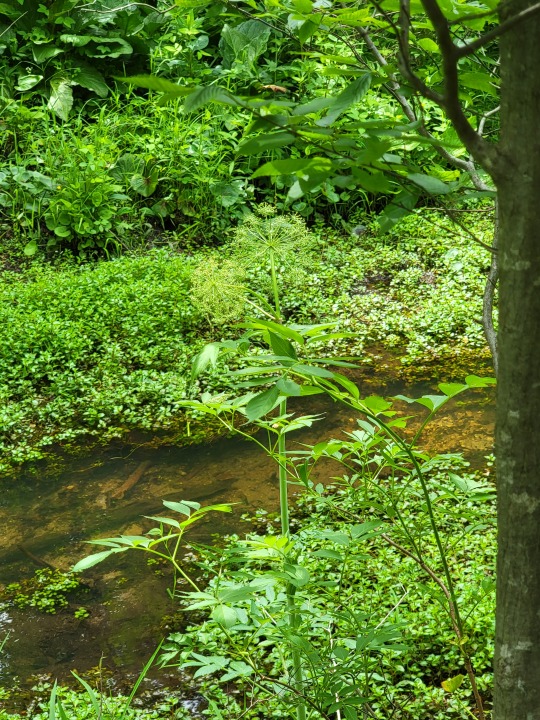
Angelica venosa,
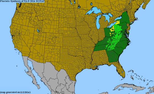
it’s amazing what a change in ph and a bit of tanic acid mixed with iron does to an ecosystem. Along the stream that passes through a section of the white cedar/ black ash tulip poplar swamp. A species more associated with a core habitat of acidic wet meadows of the Allegheny plateau and the adjacent Appalachian mountains finds it’s range limit. These iron seeps and the acidic pools of cedar duff that eventually make tea and leach out through permeable gravel banks create a unique micro habitat, only a few feet deep before meeting alkaline marl. Enough for cation exchange capacity increases, enough for nutrient requirements, enough for this species to somehow grow.

Obviously this species may be under appreciated and under studied in my opinion.
East fork State park has an acidic flat wood meadow. so does warren county. There are plenty acidic flat woods in Indiana near Versailles sp and Madison, big oaks ect. Boone co. KY is green(common) in this map. but not Cincinnati, Is it because our acidic meadow are removed from development or invasives. (maybe) there is still subtle bits of sandstone hiding at the tips of some hills, on road cuts its somewhat visible. Some springs are still lurking in private properties on the edge of Indiana and butler county along the great Miami. The concept of a species range is somewhat nebulous because it’s based on site history, how a seed moves, and the local geology and ecology.
A lot of stuff is like this, I feel like there is romanticism in finding new things and understanding more about the history of the land. I feel like people are quick to become stagnant before realizing how much of the united states is not documented at all.
youtube
This video gave me some strange ideas myself, so i contacted Joey via instagram because i was visiting oklahoma around the same time the phenology of bloom overlaps. ( i look at phenology from i naturalist observations and time of picture) then I checked to overall host ranges and the overall parasitic range on both inat and bonap. oklahoma has the panhandle counties adjacent which have the host species but not any reports on the parasite. the habitat requirements are met. Dalea frutescens as a primary host based on herbarium and i nat reports. Woody species also and scrub forbs closely related like Amorpha spp.
60% of all hosts being Dalea frutescens.
But bonaping dalea, and going through each genus to figure out if some are woody and which ones helps me figure out potential hosts.
I talked with Joey a bit about habitat which helped clarify what I was looking for.
to finalize I start planning a trip based on accessibility to areas via parks.
if you are ever curious about what was in your county, check bonap, i nat, and herbarium records. It can be fun and can benefit the worlds understanding.
#mound fen#ohio#botany#wildflowers#angelica#angelica venosa#ecology#romantacism#discovery#methods#plantblr#oklahoma#herbarium
29 notes
·
View notes
Last Seen Blogs

colourstreakgryffin
Ms. Cringeybitch

heat-of-the-assbutt
I'm a fucking shrub, alright?

art-wishes
Just some things I want to buy

juliaprecourt
Julia Precourt

tattoo310
tattoo310