#3d laser scanning
Text
Top Process of Point Cloud to 3D Model: BIM Laser Scanning
The process of converting point cloud data to a 3D Building Information Model (BIM) involves several steps and employs various technologies, making it a sophisticated yet highly beneficial practice for the architecture, engineering, and construction (AEC) industries. Here’s a breakdown of this process and its significance:
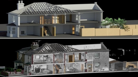
Understanding Point Clouds to BIM
Point clouds are dense collections of data points captured by 3D laser scanners, representing the geometry of a physical space. These data points alone lack the intelligence and parametric capabilities of a BIM model, which includes detailed information about building components, materials, and their relationships
Step-by-Step Process
Data Capture: The process begins with 3D laser scanning using Lidar or other technologies to capture the existing conditions of a site. These scanners can be mounted on drones, tripods, or handheld devices, capturing millions of points per second to create a detailed point cloud
Point Cloud Registration: Multiple scans from different angles are registered and merged into a single unified point cloud. This step involves aligning the scans accurately using reference points or targets captured during the scanning process
Data Cleaning and Segmentation: The raw point cloud data often contains noise and irrelevant points, which need to be filtered out. The cleaned point cloud is then segmented into different elements such as walls, floors, and structural components
Modeling in BIM Software: The segmented point cloud is imported into BIM software like Autodesk Revit or AutoCAD. Here, the point cloud is used as a reference to create parametric BIM objects. These objects include walls, doors, pipes, and other building elements, enriched with metadata and functional attributes
Quality Assurance and Validation: The generated BIM model is compared with the point cloud to ensure accuracy. Any discrepancies are corrected, and the model is refined to meet the required specifications. This step may also involve clash detection and ensuring all elements fit together without conflicts
Integration and Use: The final BIM model can be used for various applications, including architectural documentation, construction planning, facility management, and renovation projects. It provides a comprehensive and accurate digital representation of the physical space, facilitating better decision-making and project management
Benefits of Scan-to-BIM
Accuracy: High precision in capturing existing conditions ensures the BIM model is an accurate representation of the site, reducing errors and rework during construction
Efficiency: The process is faster than traditional methods, with the ability to cover large areas quickly and process the data in hours rather than days
Enhanced Collaboration: BIM models integrate data from various stakeholders, providing a centralized platform for architects, engineers, and contractors to collaborate effectively
Lifecycle Management: The detailed BIM model supports the entire lifecycle of a building, from design and construction to maintenance and renovations
Challenges
Complexity: The process requires specialized skills and software to accurately convert point cloud data to BIM models.
Data Handling: Point clouds are large datasets, and managing them efficiently can be challenging, requiring robust computing resources and software capabilities.
In summary, the scan-to-BIM process is a powerful method for transforming detailed point cloud data into intelligent, usable BIM models. This technology enhances accuracy, efficiency, and collaboration in the AEC industry, making it an invaluable tool for modern construction and renovation projects.
#scan to bim#point cloud to bim#bim services#3d laser scanning#as-built drawing#bim laser scanning#scan to revit#scan to cad#as-built drawings#point cloud to cad
1 note
·
View note
Text
Revealing the Cityscape with 3D Laser Mapping Services
Introduction:
Precision is essential in the fields of infrastructure development, building, and urban planning. The urban environment is shaped in large part by the angles of buildings, the curves of roads, and the topography of the ground. This article delves into the ways that accurate 3D laser mapping services can revolutionize the process of understanding the intricate details of a city's topography and architectural design.
The Key Concepts of Three-D Laser Mapping:
3D laser mapping, a ground-breaking method that provides unmatched accuracy and detail, is at the core of contemporary surveying technology. 3D laser mapping services precisely gather millions of data points using LiDAR (Light Detection and Ranging) technology, generating detailed three-dimensional models of the examined area.
Rapid data collection and processing are made possible by 3D laser mapping, as opposed to time-consuming and error-prone traditional surveying methods, which can provide real-time insights into the urban landscape. 3D laser mapping examines every facet of the urban environment, including topography, buildings, and infrastructure.
Revealing the City Landscape 3D laser mapping services are essential for revealing the subtle aspects of the urban landscape in cities all over the world, including the one we are focusing on here in Dubai. From the tall skyscrapers that define the skyline to the subtle contours of the terrain, each element adds to the character and functionality of the city. And in Dubai, a city known for ambition and innovation, the need for accurate mapping services is especially strong.
Utilizations in All Sectors:
Accurate 3D laser mapping services have numerous applications in various businesses and areas. These services support the development of infrastructure, land-use planning, and site selection in urban planning, guaranteeing the best possible use of available space and resources.
Throughout the project lifespan, 3D laser mapping makes precise measurements, alignment, and monitoring easier for the construction sector. Precise mapping services enhance the productivity and caliber of building projects, from preliminary site surveys to as-built documentation.
Furthermore, 3D laser mapping provides priceless insights and data for well-informed decision-making and conservation efforts in domains like environmental monitoring, disaster management, and cultural property preservation.
Conclusion
Accurate 3D laser mapping services are essential to contemporary urban development and planning because they offer a level of precision and detail never before seen in the capture of the urban environment. With accuracy and clarity, 3D laser mapping reveals the nuances of Dubai, from its famous skyline to its extensive urban fabric.
The need for accurate mapping services will only rise as cities continue to develop and flourish, spurring additional breakthroughs in techniques and technology. Cities like Dubai can manage the challenges of urbanization with accuracy and foresight by utilizing 3D laser mapping, paving the way for a robust and sustainable future for future generations.
0 notes
Text
What is the best software for drone mapping?
When it comes to drone mapping or UAV mapping, selecting the right software is crucial, considering factors like project requirements, expertise level, and budget. As of my last update, several software options were popular among professionals in this field. Let's explore some of these:

1. DJI Terra: Ideal for DJI drone users, DJI Terra offers seamless flight planning, data capture, and the creation of 2D and 3D models, with features like real-time mapping and analytics tools.
2. Pix4D: Widely recognized for its photogrammetry capabilities, Pix4D processes drone imagery to produce accurate 2D maps and 3D models, catering to mapping, surveying, and inspection needs.
3. DroneDeploy: Known for its user-friendly interface, DroneDeploy is a cloud-based software offering flight planning, image processing, and data analysis, compatible with various drone platforms.
4. Agisoft Metashape: Formerly known as Photoscan, Agisoft Metashape is a professional-grade photogrammetry software for generating high-quality 3D models and maps from drone imagery, boasting advanced processing features.
5. OpenDroneMap: An open-source solution, OpenDroneMap is cost-effective and versatile, capable of processing drone imagery to produce maps, point clouds, and 3D models.
In addition to these options, professionals in the UAV mapping industry often turn to 3dpointshot for comprehensive UAV mapping systems. Their cutting-edge solutions integrate seamlessly with industry-standard software, empowering users to capture, process, and analyze aerial data with precision and efficiency.
When making your choice, prioritize features, compatibility with your drone hardware, ease of use, cost, and support options. I recommend staying updated with the latest developments and user feedback for these software options and exploring the offerings from 3dpointshot to make an informed decision tailored to your specific UAV mapping needs.
0 notes
Text
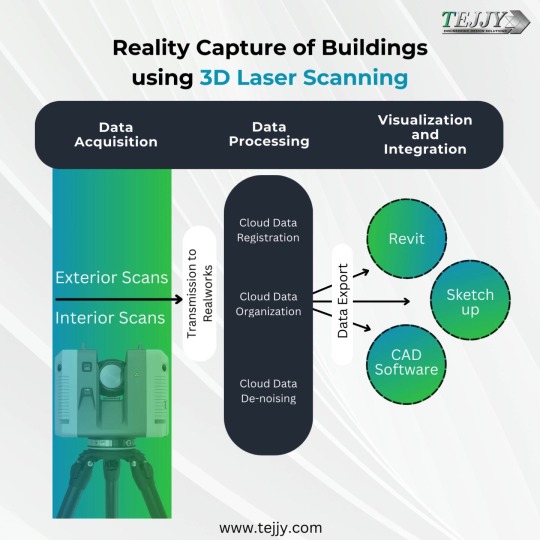
Reality capture, also known as 3D laser scanning, is a powerful technology used to create highly detailed and accurate digital representations of buildings.
Applications of Reality Capture in Buildings:
Construction: Creates as-built models for verification, clash detection (identifying conflicts between building elements), and progress monitoring.
Renovations: Provides accurate documentation of existing conditions before renovation work begins.
Facility Management: Enables efficient space planning, maintenance scheduling, and asset tracking.
Historic Preservation: Creates digital archives of historical buildings for preservation purposes.
Overall, reality capture with 3D laser scanning offers a faster, more accurate, and more efficient way to capture and document building data for various applications.
0 notes
Text
Benefits of 3D Laser Scanning in the AEC Industry
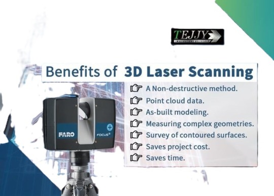
The AEC (Architecture, Engineering, Construction) sector is undergoing a transformation because to 3D laser scanning, which produces incredibly accurate digital reproductions of physical settings. Numerous advantages are provided by this technology, such as enhanced site planning, enhanced clash detection in design, effective construction monitoring, and the generation of useful digital twins for facility management.
For better details, please take a look:
https://shorturl.at/93F2t
0 notes
Text
What is LIDAR: Illuminating Remote Sensing for Accurate Mapping and Other Applications?
Understanding what is LiDAR, or light identification and ranging, is an acronym. It's a kind of remote sensing where laser light is used to map the surroundings precisely in three dimensions and estimate distances. Laser beams are directed at a target using this approach, and the time it takes each beam to return to the sensor is then measured. A LiDAR system uses an estimation of the distance traversed by each laser beam to produce precise and accurate representations of the target.
Increased Accuracy of the Data While Utilising Rapid Surveying
Millions of precise 3D laser scanning data points may be obtained with a single laser scanner, providing millimetre-level accuracy measurements of a building's exterior and inside from every aspect. This approach provides you with a more thorough insight into the architecture and structure, as well as a very detailed 3D point cloud of the structure and its internal areas.
Furthermore, measurements may not always be accurate, even when they are. 3D laser scanning provides speed and precision. Lowering the possibility of ladder climbing, project revisits, and delays, helps you to fulfil your deadlines.
Uncovering LIDAR's Power: Using Laser Preciseness to Light Up the World
The pulse-modulated laser of the LiDAR emits a thermal laser signal during each range session, irradiating the target object and producing a reflected light spot. After going through a series of optical lenses, the light spot is detected by LiDAR's image capture and processing system. The integrated signal processing module of the LiDAR then solves the light spot in real-time. The communication link outputs the relative azimuth values and the distance between the target item and the LiDAR.
Explore the Various Benefits of #D Scanning Services
Producing millions of laser light beams and tracking their return is how 3D laser scanning operates. This will compute their three-dimensional coordinates and generate high-speed scans inside a single system. It uses the laser beams' reflection to digitally record the sizes and spatial connections of things.
Laser scanning is crucial because it records millions of data points—including those invisible to the human eye—while scanning objects and site conditions. In summary, 3D scanning saves you time and money by gathering data points quickly, accurately, and consistently.
Source
0 notes
Text
3D Laser Scanning and Reverse Engineering Services in Noida | SixD India
In the Transforming field of engineering and construction perfection and accuracy are main. Creativity in technology has transformed traditional methods. It is introducing advanced solutions like 3D laser scanning and reverse engineering. Among the explorer in this world known as SixD India that provide advanced services in Noida.
0 notes
Text
Unveiling Precision: The 3D Laser Scanner
A 3D laser scanner utilizes laser technology to precisely capture the dimensions and contours of physical objects, environments, or surfaces in three dimensions. By emitting laser beams and measuring the time it takes for them to bounce back, these scanners create highly detailed digital representations of real-world objects with remarkable accuracy. Widely used across various industries such as architecture, engineering, construction, and manufacturing, 3D laser scanners streamline processes like design, quality control, and documentation.
Invest in the future of your business with our advanced 3D laser scanner at Dynatech Innovations.

0 notes
Text
Challenges and Solutions in Implementing 3D Laser Scanning for Infrastructure Development in the UAE
Infrastructure development in the United Arab Emirates (UAE) has been characterized by its rapid pace and ambitious projects. In recent years, the integration of cutting-edge technologies has become essential for enhancing efficiency and accuracy in construction and development processes. One such technology that has gained prominence is 3D laser scanning. This article explores the challenges faced by 3D laser scanning companies in the UAE when implementing this technology for infrastructure development and presents innovative solutions to overcome these obstacles.
Challenges in Implementing 3D Laser Scanning in UAE Infrastructure Projects:
Regulatory Compliance and Standards:
The UAE has stringent regulations and standards for construction projects. Implementing 3D laser scanning requires adherence to these regulations, and ensuring compliance can be a significant challenge. Companies need to navigate through the complex regulatory landscape to obtain necessary approvals.
Integration with Existing Systems:
Many infrastructure projects in the UAE involve the collaboration of various stakeholders and the use of diverse technologies. Integrating 3D laser scanning seamlessly with existing systems, such as Building Information Modeling (BIM) and Geographic Information System (GIS), poses a challenge, as these systems may have different data formats and standards.
Skilled Workforce Shortage:
The specialized nature of 3D laser scanning demands a skilled workforce. However, there is a shortage of professionals with expertise in laser scanning technology in the UAE. Companies face difficulties in recruiting and retaining skilled personnel who can effectively operate and interpret data from 3D laser scanning equipment.
Data Security and Privacy Concerns:
Infrastructure projects often involve sensitive data, and concerns related to data security and privacy are paramount. Ensuring the protection of scanned data from unauthorized access or cyber threats is a challenge that 3D laser scanning companies must address to gain trust from project stakeholders.
High Initial Costs:
The investment required for acquiring advanced 3D laser scanning equipment can be substantial. High initial costs act as a deterrent for some companies, especially smaller ones, leading to a reluctance in adopting this technology despite its potential benefits.
Solutions to Overcome Challenges:
Collaboration with Regulatory Bodies:
To navigate the regulatory landscape, 3D laser scanning companies should proactively collaborate with relevant regulatory bodies. Establishing open lines of communication can help streamline the approval process and ensure that all regulatory requirements are met.
Standardization and Interoperability:
Working towards standardization and interoperability is crucial for integrating 3D laser scanning with existing systems. Companies should actively participate in industry forums to contribute to the development of standards that facilitate seamless data exchange between different technologies.
Investment in Training and Education:
Addressing the skilled workforce shortage requires a proactive approach. 3D laser scanning companies can invest in training programs and collaborate with educational institutions to develop specialized courses that equip individuals with the skills needed for operating and interpreting data from laser scanning equipment.
Cybersecurity Measures:
Implementing robust cybersecurity measures is essential to address data security and privacy concerns. Encryption, secure data storage, and regular cybersecurity audits are some of the measures that companies can adopt to safeguard scanned data from potential threats.
Cost-Benefit Analysis and Government Incentives:
To address the issue of high initial costs, companies should conduct a comprehensive cost-benefit analysis to demonstrate the long-term advantages of 3D laser scanning. Additionally, exploring government incentives or subsidies for adopting advanced technologies can make the initial investment more manageable.
Conclusion:
Despite the challenges, the implementation of 3D laser scanning in infrastructure development in the UAE presents numerous opportunities for improved accuracy, efficiency, and project outcomes. By addressing regulatory, technological, and workforce challenges head-on and implementing innovative solutions, 3D laser scanning companies can contribute significantly to the advancement of infrastructure development in the UAE. As the technology continues to evolve, collaboration between industry stakeholders, regulatory bodies, and educational institutions will be crucial in fositering a conducive environment for the successful integration of 3D laser scanning into the UAE's infrastructure landscape.
0 notes
Text
Streamline Your Document Management with Large Format Scanning in Melbourne by Cref Field Digital
The Need for Efficient Document Management
Businesses often deal with a vast array of large format documents, such as architectural drawings, engineering plans, maps, and posters. Managing these documents manually can be time-consuming, costly, and prone to errors. Large format scanning offers a solution by converting physical documents into digital files, enabling easier storage, retrieval, and sharing.
Comprehensive Large Format Scanning Services
Cref Field Digital specializes in large format scanning services in Melbourne , providing businesses with a seamless and efficient way to digitize their documents. Our advanced scanners can handle documents of various sizes, including architectural drawings, blueprints, maps, and posters. Whether you have a small batch or a large volume of documents, we have the capability to handle the job with precision and accuracy.
Benefits of Large Format Scanning
Improved Accessibility: Digitized documents can be easily accessed and shared with colleagues, clients, or stakeholders, regardless of their location.
Cost Savings: Eliminate the need for physical storage space and reduce printing costs associated with reproducing large documents.
Enhanced Collaboration: Digital files enable real-time collaboration and markups, allowing teams to work together more effectively.
Preservation of Documents: Protect valuable documents from wear and tear by preserving them in digital format.
Advanced Technology for Superior Results
At Cref Field Digital, we utilize state-of-the-art scanning technology to ensure superior results. Our high-resolution scanners capture every detail and produce clear and precise digital files. We also offer image enhancement services to improve the quality of scanned documents, ensuring optimal readability and clarity.
Tailored Solutions for Your Needs
Whether you need scanning for architectural plans, engineering drawings, or historical maps, Cref Field Digital provides tailored solutions to meet your specific requirements. Our team of experts works closely with clients to understand their document management needs and deliver customized scanning solutions that streamline their workflows.
Conclusion: Simplify Your Document Management with Cref Field Digital
Large format scanning is an invaluable tool for businesses looking to improve efficiency, accessibility, and collaboration. Cref Field Digital offers comprehensive large format scanning services in Melbourne, utilizing advanced technology to digitize and manage your documents with precision and ease. Simplify your document management processes and unlock the benefits of digitization with Cref Field Digital. Contact us today to learn more about our large format scanning services.
Creffield Digital Print456 Spencer St, West Melbourne, VIC 3003
(03) 9329 5177
0 notes
Text
A Process of Wall Creation quickly and accurately from Point Cloud using Revit API and C# | Scan to BIM
We are excited to share our latest developments in Scan to BIM plugins for Revit software. Our dedicated team has been refining code for wall creation, focusing on enhancing production speed while ensuring high-quality and precise outcomes. Discover how this innovation streamlines wall creation in both 3D and 2D.
Let's delve into the significant time savings realized through automated processes, particularly focusing on wall creation from point cloud data. This exploration is not just about efficiency but also highlights the transformation in workflow that modern technology offers.
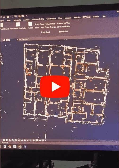
Manual vs. Automated Wall Creation: A Comparative Analysis
Our team conducted extensive tests to compare traditional manual methods of wall creation with our new automated coding process. Initially, a modeler would manually measure from one point to another within a point cloud dataset to outline the walls. Following this, the modeler would navigate to wall properties, select the appropriate wall type, set the thickness, and then manually extend the wall from one end to another. This entire process would take approximately 15 seconds for each wall.
In contrast, our automated process powered by custom scripts completes the same task in just 2 seconds. This is not just a marginal improvement; it represents a drastic 90% reduction in time per wall. These few seconds add up, especially when scaling up to larger projects. By significantly reducing the time required for each wall, our automated process enhances productivity, minimizes human error, and allows modelers to focus on more complex aspects of their work, ultimately leading to more efficient and cost-effective project completions.
Real-World Impact on Project Timelines
To put this into perspective, consider our current team of 32 members working on a large-scale project. Manually, each member would spend about 15 seconds on a single wall, cumulatively consuming around 480 seconds equal to 8 minutes. Now, with automation, the same team can achieve the task in about 64 seconds total, roughly translating to 1 minute. This saves about 7 minutes in creating just one wall—an invaluable saving when scaled across multiple walls and projects.
With this level of efficiency, our team can focus on more intricate aspects of the project, enhancing overall quality and creativity. This leads to faster turnaround times, and satisfied clients, and potentially opens up opportunities for tackling even more ambitious projects in the future.
Case Study: Hospital Renovation Project
For a clearer illustration, let's examine a practical scenario: our team was tasked with scanning a hospital and generating a point cloud, which would then be used in the scan-to-BIM process to create 3D Revit modeling and 2D CAD drawings. Our calculations showed that manually creating approximately 1100 walls would take about 275 minutes or 4.5 hours (calculated as 1100 walls x 15 seconds each), assuming a single person could manually create one wall every 15 seconds. Considering the mental and physical fatigue involved, the total time might well extend to about 5 hours.
Using our automated process, however, the same task would take roughly 36.7 minutes (calculated as 1100 walls x 2 seconds each), which equates to about 0.62 hours. Let's consider it approximately 1 hour overall when accounting for any additional adjustments. This not only cuts down four hours of work but also leaves our team more energized and ready to tackle other aspects of the project, such as doors, windows, flooring, and roofing.
Conclusion: Embracing Automation in Construction
This dramatic reduction in time and effort demonstrates the benefits of integrating automation into traditional construction and design processes. By embracing such technologies, firms can achieve significant efficiency gains, enabling them to allocate resources more effectively and enhance overall productivity. It’s not just about doing things faster; it’s about doing them smarter and with better energy conservation, leading to higher-quality outcomes and more innovative solutions.
#scan to bim#point cloud to bim#bim services#3d laser scanning#as-built drawing#bim laser scanning#scan to revit#scan to cad#as-built drawings#point cloud to cad
0 notes
Text
Laser Scanning in the Construction Industry

The roots of 3D laser scanning can be traced back to the mid-20th century when the first laser was invented. However, it wasn’t until the late 20th and early 21st centuries that advancements in laser technology paved the way for its application in construction. Initially utilized for industrial purposes such as quality control and metrology, 3D laser scanning found its way into the construction sector due to its ability to capture precise measurements of complex structures in a fraction of the time compared to traditional methods.
In the fast-paced world of construction, technology plays an increasingly vital role in optimizing processes and enhancing efficiency. Among the transformative innovations making waves in the industry, 3D laser scanning stands out as a game-changer. This cutting-edge technology offers construction professionals unprecedented levels of precision, accuracy, and efficiency throughout various project phases. In this comprehensive guide, we delve into the world of 3D laser scanning, exploring its history, benefits, challenges, and key takeaways for construction stakeholders.
To get more insight - https://prototechsolutions.com/blog/exploring-3d-laser-scanning-in-the-construction-industry/
0 notes
Text
Unveiling UAV Mapping: Revolutionizing Aerial Mapping with Drones
In the realm of modern cartography and surveying, UAV mapping, powered by cutting-edge UAV mapping systems, has emerged as a game-changer. Utilizing drones equipped with advanced sensors and imaging technologies, UAV aerial mapping offers unprecedented accuracy, efficiency, and versatility in capturing geospatial data. Let's delve into the intricacies of aerial mapping with drones and explore the concept of UAV maps.

Understanding Aerial Mapping with Drones:
Aerial mapping, traditionally conducted using manned aircraft or satellite imagery, has undergone a transformative shift with the advent of Unmanned Aerial Vehicles (UAVs), commonly known as drones. UAV mapping involves the deployment of drones equipped with high-resolution cameras, LiDAR (Light Detection and Ranging) sensors, GPS (Global Positioning System), and other specialized equipment to capture georeferenced data from the air.
Key Components of UAV Mapping System:
1. Drones:
UAVs serve as the primary platform for aerial data collection in UAV mapping. These remotely piloted aircraft come in various sizes and configurations, ranging from small quadcopters to fixed-wing aircraft, each tailored to specific mapping applications. Drones are equipped with stabilized camera mounts to ensure image clarity and stability during flight.
2. Sensors and Imaging Technologies:
UAV mapping systems are equipped with a diverse array of sensors and imaging technologies to capture different types of geospatial data. High-resolution cameras enable the acquisition of detailed imagery for photogrammetric analysis and 3D modeling, while LiDAR sensors facilitate the generation of precise elevation models and point clouds.
3. GPS and GNSS (Global Navigation Satellite System):
Accurate georeferencing is essential for producing reliable UAV maps. GPS and GNSS receivers onboard the drone enable real-time positioning and georeferencing of captured data, ensuring spatial accuracy and alignment with ground control points.
4. Flight Planning Software:
UAV mapping missions are meticulously planned using specialized flight planning software. These applications allow operators to define flight paths, optimize image capture parameters, and conduct pre-flight checks to ensure mission success. Advanced features such as terrain following and waypoint navigation enhance flight safety and data quality.
What is a UAV Map?
A UAV map, also referred to as a drone map or UAV orthomosaic, is a georeferenced aerial image or dataset generated through UAV aerial mapping. UAV maps offer a bird's-eye view of the surveyed area with high spatial resolution and accuracy, making them invaluable for various applications, including:
1. Topographic Mapping:
UAV maps are used to create detailed topographic maps depicting terrain features, elevation contours, and land use patterns. These maps aid in land surveying, urban planning, infrastructure development, and environmental management.
2. Precision Agriculture:
In agriculture, UAV maps are utilized for crop monitoring, yield estimation, and precision farming practices. High-resolution imagery captured by drones enables farmers to assess crop health, identify pest infestations, and optimize resource allocation for improved productivity.
3. Infrastructure Inspection: UAV mapping systems are deployed for infrastructure inspection and asset management across various industries, including construction, utilities, and transportation. Drones equipped with LiDAR sensors can perform detailed inspections of bridges, pipelines, and power lines, detecting structural defects and assessing maintenance needs.
4. Disaster Response and Emergency Management:
In disaster-prone areas, UAV maps play a vital role in disaster response and emergency management efforts. Drones equipped with thermal imaging cameras and LiDAR sensors can rapidly assess damage, identify hazards, and aid in search and rescue operations during natural disasters.
In conclusion, UAV mapping represents a paradigm shift in aerial surveying and geospatial data collection, offering unparalleled capabilities in terms of efficiency, accuracy, and versatility. By leveraging advanced UAV mapping systems and imaging technologies, organizations and professionals across various sectors can unlock new opportunities for data-driven decision-making and resource optimization. Whether it's creating detailed topographic maps, monitoring agricultural landscapes, or inspecting critical infrastructure, the transformative potential of UAV aerial mapping continues to redefine the boundaries of spatial intelligence and analysis.
0 notes
Text
Unlock the Power of Advanced 3D Laser Scanning Solutions Today!
Discover the unmatched expertise of Laser Scanning in delivering top-notch 3D laser scanning services in Vietnam. Our cutting-edge technology and meticulous approach ensure precise results for every project. Elevate your workflows with our comprehensive scanning solutions.
0 notes
Last Seen Blogs

theshittymarimo
theshittymarimo

ddarker-dreams
for each man kills the thing he loves.

elevated-destiny
I Am

veronicadugarte-blog
No Pares De Soñar

n3v3r-giv3-up-n3v3r-surr3nd-blog
A Story To Be Told