maps-of-my-interest
M A P S
All the maps I post on here I have made myself! I use Adobe Ideas and Pages on my iPad to do so. various maps of various descriptions. Id be happy to consider any requests ~ Leòdhas is my personal blog.
24 posts
Don't wanna be here? Send us removal request.
Last Seen Blogs

blantonblanton2
Без названия

allanlewisallan
Deskshop | Allan Lewis

emmasexslave
Emma
jolly-jim-the-mystery-tree
Cow Chop

mandivine-blog
embrace your ideas
Photo
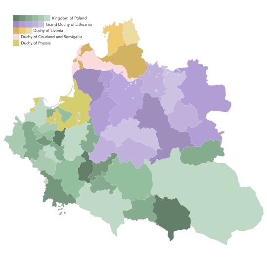

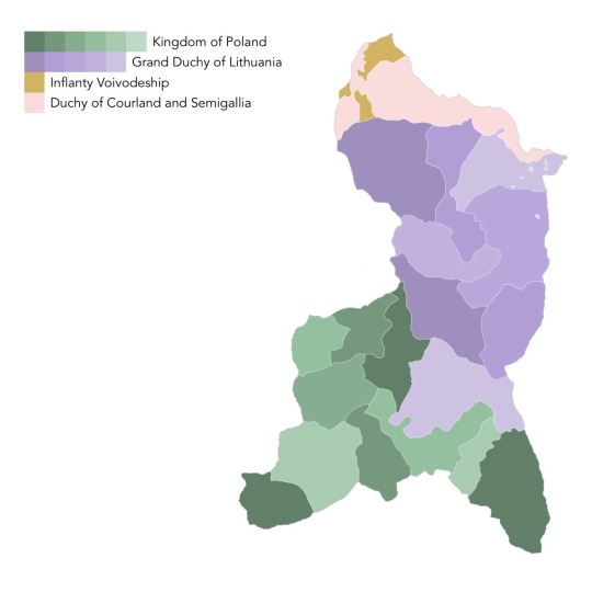
The Polish Lithuanian Commonwealth and its subdivisions at prominent moments in its history. At its largest extent in 1619, after its first territorial losses in the 17th century, after the First Partition and after the Second Partition before its formal dissolution in 1795.
24 notes
·
View notes
Photo
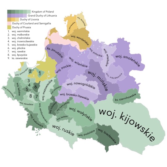
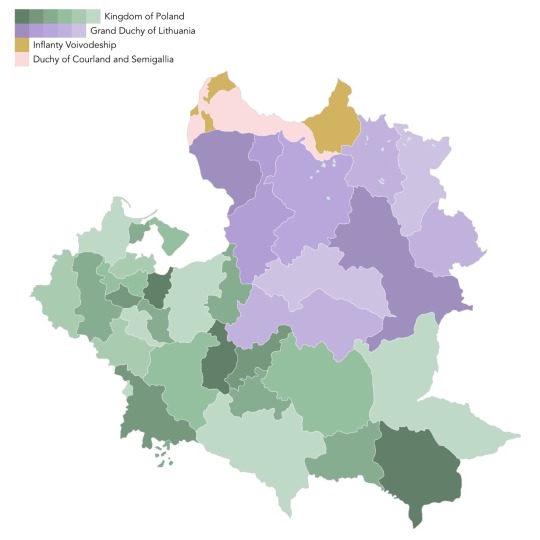
In a series of a few maps I’ll make of the Polish Lithuanian-Commonwealth this one is of the local administrative regions or Voivodeships/Województwa, a second tier system of regional government below the largely ceremonial Provinces/Prowincja. This is the administrative situation at the Commonwealths zenith circa 1619.
#maps#Poland#Lithuania#Belarus#Prussia#Livonia#Estonia#Latvia#Courland#polish Lithuanian commonwealth#commonwealth#1800's#1700's#historic#history#historic maps#Poland map#polish maps#kingdom of Poland#Lithuanian#polish#Belarusian#Russia#Galicia#map blog#Silesia#lesser Poland#Greater Poland#Ruthenia#Baltic
11 notes
·
View notes
Text
Iv been so busy I haven't had a chance to make/post new maps lately but I promise some are coming soon! Also didn't realise Iv gone way past 100 followers now so thank you ☺️💯
2 notes
·
View notes
Photo
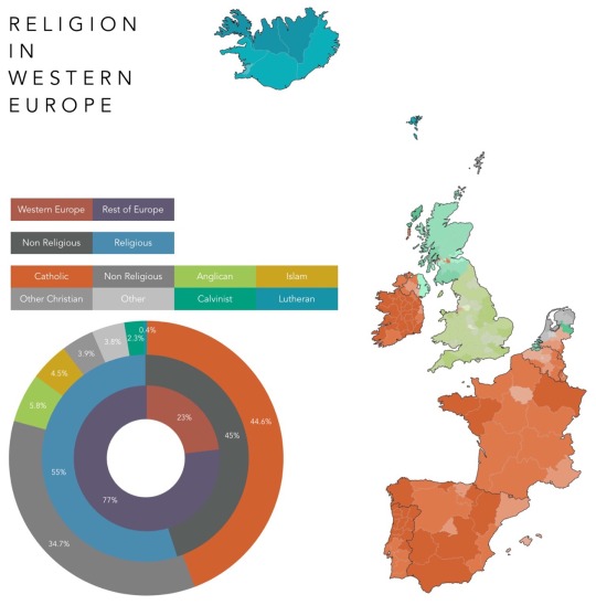
Dominant Religions in Europe
This map shows the dominant religion in each subdivision of each Western European country. Some things to note! the term ‘Western Europe’ is rather ambiguous so this is my definition of it which includes the following countries; Iceland, the UK, Ireland, the Netherlands, Belgium, Luxembourg, France, Spain, Andorra and Portugal. The following entities are also included separately; the Isle of Man (Crown dependency of the UK), Jersey and Guernsey (Crown dependencies of the UK), the Faeroes (autonomous constitute country of the Danish Realm). Monaco doesn’t show up on the map and so I have included its statistics within the France Region of Provence-Alpes-Côte d'Azur.
23 notes
·
View notes
Photo
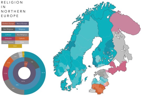
Dominant Religions in Europe
This map shows the dominant religion in each subdivision of each Northern European country. Some things to note! the ‘Regions of Europe’ are rather ambiguous (as with the last one) so this is my definition of Northern Europe which includes the following countries; Denmark, Norway, Sweden, Finland, Estonia, Latvia, Lithuania and Russia (in part). The following Russian entities included are; the Oblasts of Murmansk, Leningrad and Kaliningrad, the Republic of Karelia and the Federal City of St. Petersburg.
36 notes
·
View notes
Photo

A new language map/tree ~ this time it's the Germanic language family, thanks for the request guys!
#languages#language#language tree#language map#Germanic#German#high German#low German#linguistics#Scandinavian#Nordic#Germany#scots#Scotland#Norn#Denmark#Sweden#Swedish#Danish#Norwegian#Norway#Netherlands#Frisian#Friesland#UK#England#Bavaria#saxony#Saxon#Yiddish
875 notes
·
View notes
Photo
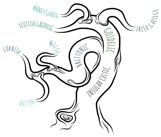
I know I said I’d do Germanic next but it’s a big one so in the meantime here is a language map/tree of the Insular Celtic language group! Just to save the confusion we had with the last one I don’t include extinct languages ~ thanks for the request!
#Language map#languages#Celtic#Celtic language#Celtic languages#language#linguistics#linguistic#Gaelic#gàidhlig#Brittonic#Goidelic#insular Celtic#Breton#Cornish#Cornwall#Welsh#wales#Scottish Gaelic#Scottish#Scotland#Hebrides#Irish#Irish Gaelic#Ireland#language tree
246 notes
·
View notes
Photo
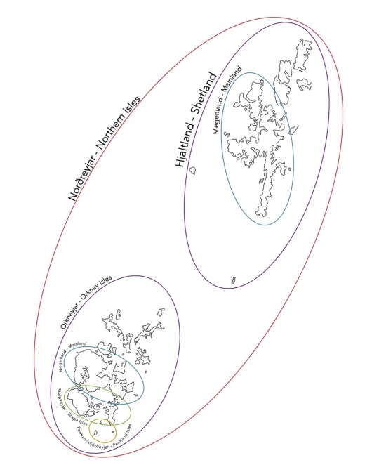
Made this a while ago - the island groups of Norðreyjar/the Northern Isles with native Norn names! I'm aware the Norn names do differ and are open to interpretation but these are the names I was made aware of when I was taught Norn.
#map#maps#geographic maps#geographic map#historic maps#historic map#Scotland#Scottish#Hjaltland#Orkneyjar#Norðreyjar#northern isles#orkney#islands#island maps#isles#Norn#Norse#Norwegian#Norway#Scandinavian#Nordic#Celtic#British isles#geography#my maps#tumblr maps#history#Scottish history#Pictish
18 notes
·
View notes
Text
Yeh so I'll do Germanic language group next for the next language map/tree as its been suggested a few time now and I had actually already started it a while back!
4 notes
·
View notes
Text
I'm gonne make another language map/tree like my last one on the Uralic language group, what group shall I do for this one?
5 notes
·
View notes
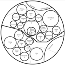
Photo
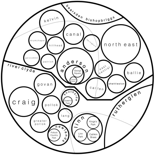
Glasgow bubble Map
My first attempt at a city bubble map. I couldn’t find a process to follow so like most of my maps I totally winged it but it came out good for a first attempt. The larger bubbles are wards of the City of Glasgow which are placed in relation to each geographically. Thanks for the suggestion!
#map#Scottish maps#Scotland#maps#map blog#Glasgow#Glasgow map#UK maps#Britain#uk#Clyde#river Clyde#Dunbartonshire#Lanarkshire#tumblr maps#bubble map#alternative map
23 notes
·
View notes
Photo
Well where each language is placed on the end branch doesn't denote anything like its relation to the language it's next to in said group (I.e. the fact Iv put Ingrian and Vod next to each other in the Baltic group is simply for presentation purposes as the words fit there better, not because I'm saying they're the closest to each other in that group) and as for Mator and Kamass, I didn't include extinct languages in this one!

Language Maps!
So Iv decided to do something a little different, not so much cartographic this time - rather a language map (presented in the form of a tree). This one Iv made is of the Uralic language family!
249 notes
·
View notes
Photo
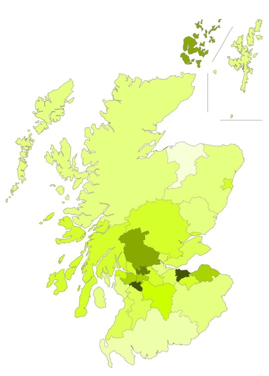
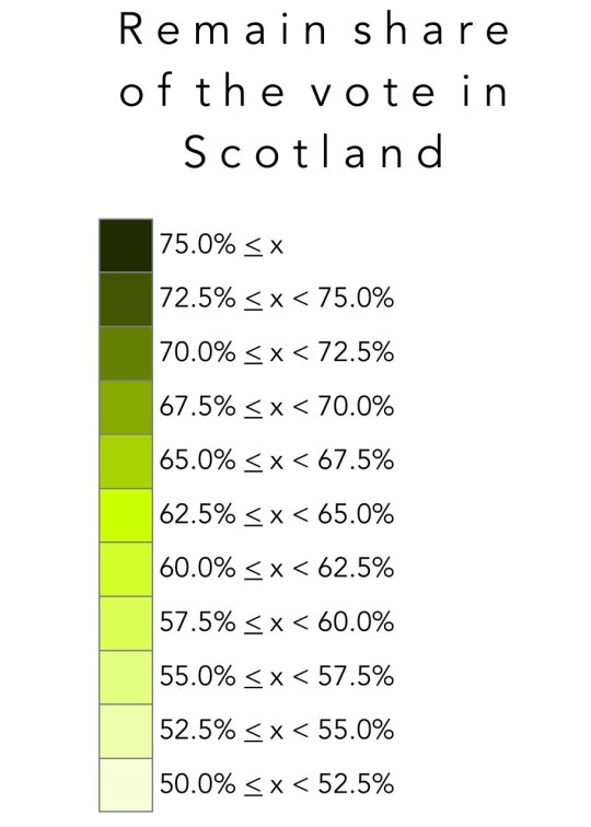
There's plenty maps out there but I fancied one for my blog! This map shows the share of the remain vote in Scotland's 32 local council areas. Some quick stats: Scotland voted 62% in favour of renaming in the EU, this is considerably higher than all but one official opinion poll suggested. Turnout was 67.2%. This is ranked 3rd in turnout in the UK behind England (73%) and Wales (71.7%) and above Northern Ireland (62.9%) but is within the expected turnout margin which was between 65%-70%. The highest remain vote was cast in Edinburgh with 74.4% of the voting electorate supporting continued EU membership and was (rather unexpectedly) followed closely by East Renfrewshire with 74.3% in favour of remain. The lowest remain vote was cast in Moray with 50.1% of the voting electorate supporting continued EU membership (Moray was the only council area predicted in the last official poll to vote leave by a small margin). It was followed by Dumfries and Galloway which voted 53.1% to remain.
#eu referendum#Scotland#referendum#vote#brexit#vote leave#vote remain#Britain#maps#election map#vote map#Europe#eu referendum map#European Union#European maps#Europe map
10 notes
·
View notes
Photo
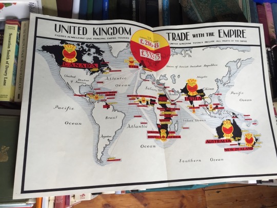
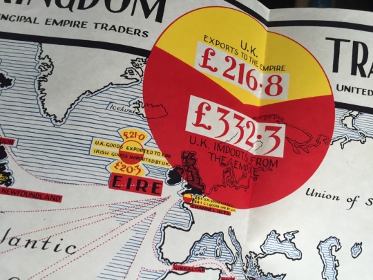
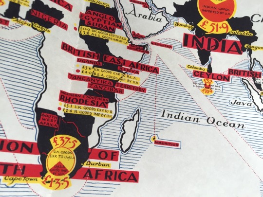
Found this poster today in an antique shop! Iv seen plenty trade maps before but this one is so clear and minimal for its time I like it (may do a digital repro of it for this blog if you guys think it’d be worth doing?!)
#trade map#map poster#poster#map#British empire#empire#imperial#trade#British raj#imperialism#history#historic map#historic maps#statistics#data#uk#Uk maps
9 notes
·
View notes
Photo
Language Maps!
So Iv decided to do something a little different, not so much cartographic this time - rather a language map (presented in the form of a tree). This one Iv made is of the Uralic language family!
#Uralic#Uralic languages#Uralic people#Hungarian#Hungary#Estonian#Estonia#Finnish#Finland#languages#linguistics#language map#language maps#language tree#Russia
249 notes
·
View notes
Photo
Dominant Religions in Europe
This map shows the dominant religion in each subdivision of each Northern European country. Some things to note! the ‘Regions of Europe’ are rather ambiguous (as with the last one) so this is my definition of Northern Europe which includes the following countries; Denmark, Norway, Sweden, Finland, Estonia, Latvia, Lithuania and Russia (in part). The following Russian entities included are; the Oblasts of Murmansk, Leningrad and Kaliningrad, the Republic of Karelia and the Federal City of St. Petersburg.
#Northern Europe#Europe#European maps#maps of Europe#Nordic#Scandinavia#Denmark#Norway#Sweden#Finland#Murmansk#Karelia#Leningrad#St. Petersburg#Estonia#Latvia#Lithuania#Kaliningrad#Baltic#map#maps#religion#religious map#catholic#Protestant#Orthodox#Lutheran#Islam
36 notes
·
View notes
Photo
Dominant Religions in Europe
This map shows the dominant religion in each subdivision of each Western European country. Some things to note! the term ‘Western Europe’ is rather ambiguous so this is my definition of it which includes the following countries; Iceland, the UK, Ireland, the Netherlands, Belgium, Luxembourg, France, Spain, Andorra and Portugal. The following entities are also included separately; the Isle of Man (Crown dependency of the UK), Jersey and Guernsey (Crown dependencies of the UK), the Faeroes (autonomous constitute country of the Danish Realm). Monaco doesn’t show up on the map and so I have included its statistics within the France Region of Provence-Alpes-Côte d'Azur.
#map#Europe#Western Europe#Faeroes#Iceland#UK#Ireland#Netherlands#Scotland#England#Belgium#France#luxembourg#Spain#Portugal#Monaco#Andorra#religion#catholic#Lutheran#Calvinist#Christianity#Islam#atheist#religious map#religious history
23 notes
·
View notes