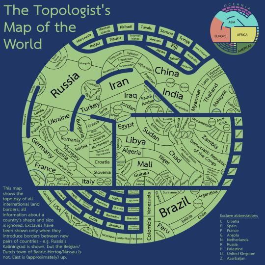
#topological maps
Photo
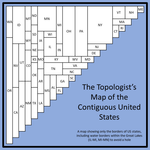
A topologist map of the US showing all state borders
827 notes
·
View notes
Text

Curious Tale Mapmaking
On Sunday I finally made the fist visual representation of the City of Sele, the city-state under the Sheer in Relance and the nucleus and origin point of Vardas Gala. I have been writing war stories from survivors of the Hero's invasion, which has necessitated the use of locational details.
After having haphazardly and very slowly collected details on the lay of Sele over just more than a decade, it was finally getting to the point where I was worried about forgetting things I had already creating, superimposing separate locations geographically, and otherwise creating continuity errors in general.
What I have done here is obviously about as primitive as a map can get; it's purely for my own personal reference but I thought it might also be interesting to some of you. Most of these locations are not mentioned in the Prelude, but readers of that work will recognize some of them.
This is an unfinished map, both in the sense that the empty areas are largely yet to be filled in rather than being actually empty and in the sense that (some) existing locations are subject to change. It is also subject to relative error: The Butter Bowl District (home to Crawler's Mouth i.e. the entrance to the Perse Hollows) is explicitly listed in my notes as encompassing the intersection of the city's north–south and west–east meridians, but on this map it is skewed north. And the size of the text on the map also forces some error; for instance, the Academy actually sits mainly on Student Ridge. There are also errors of angularity: Not everything is as neatly laid out west-to-east and north-to-south as this map implies. This will all be corrected in published canonical works.
In terms of its actual, in-world urban development, Sele is more developed in the north and the west than in the south and the east. The north–south axis in particular is strongly correlated with population density, though of course the central districts are the most populous of all. This is because the city generally began in the north, along the Cliffs of Raglan. The Fortress of Galadrim took many years to build but it was a construction site from the very beginning and its placement was indeed the entire reason the city was built at this location along the Shos Plateau. The Academy was built early on too, creating a southwest–northwest axis between the two that saw the earliest and most intense development. For many years following that, development focused in the northwestern direction, filling out the available space east of the World-Facing Palisades, until finally that space was used up and the city began to build southward, culminating in Southtown and only very recently just beginning to fill out the eastern and southeastern marches. (In fact, the southeast quadrant of the map actually is very sparsely developed and not just empty because I haven't conceived and named many of its locations yet.)
The many "ridges" you see referenced, along with the "palisades" westering the city, are the result of Landstorm topography. The entire Sourran Landstorm in the east of the world (which is also where Ieik was located) is an extreme high-elevation (generally about 11,000 feet above sea level, give or take several thousand feet) series of plateaus. You can think of it as a tiled gaming board, like a chessboard or a D&D hexmap (except the tiles are all of irregular shape and varying size), where each tile is a relatively flat expanse of land called a finger. All of the fingers are at essentially random elevations relative to one another, creating oftentimes impassable escarpments or even sheer cliffs. Galan relanceworks (i.e. earthworks) have transformed some of these boundaries into developable hills. The "ridges" on the map may therefore refer to: 1) impassable escarpments between fingers; 2) sloping hillsides either built by relanceworks or, rarely, naturally-occurring; or 3) high-elevation fingers relative to the rest of the city. Some ridges are a combination or two or more of these features.
I spent quite a lot of effort combing through my notes, manuscript text, and unplaced scenes to capture hopefully all of the various named areas within Sele. If I missed any, the number is very small and these locations might be able to be squeezed into the map later.
I also had the chance to create and name new locations, and finally give names to previously established but unnamed locations. This map reflects most of that work, although there is considerably more development in the northwest and central-southwest areas than this map implies. Also, immediately west of Galadrim is a large works area: yards and warehouses and staging grounds and so forth, mainly in service of the Fortress. The city plan calls for this area to eventually be mostly converted to residential use.
I am already making inferences about various characters based on where they live in the city, so in that regard alone this map is already a help.
Speaking of things you might have expected that I would have done a long time ago, on Saturday I wrote the preliminary text treatments on another two of the Twelve Powers of Junction in my canonical document on that subject, following the serendipitous discovery that I had actually conceived and named the Fifth Power all the way back in a Curious Tale Saturdays article in 2018! I had completely forgotten about this and only rediscovered it due to my research for writing those war stories. The Twelve Powers are the foundations of reality and are the primary source of "magic" in the world, and so are important to the story in numerous ways. Writing up a treatment of the Fifth Power wasn't hard since I'd already mostly done it in 2018, and then I went ahead and wrote the Eleventh Power treatment to give a home to one of the Nine Clouds I have named in Chapter 1 of ATH and link some related concepts together under one umbrella. (Each Power, in excess, generates an associated waste Cloud; don't ask why the numbers don't match.) This brings the total number of named Powers to seven and the number of Powers with treatments to six—meaning I'm halfway there!
One of the reasons I haven't done things like fully flesh out worldbuilding control documents like the Sele Map or the Twelve Powers overview is that generally I am wary of the premature concrete-pouring that can happen with top-down designs. I don't want to use up all the space in Sele in case I want to place something else later that I presently haven't created. Same thing with the Twelve Powers: They have a number so I can't just go tacking on more; there are twelve of them and that's it. I want to leave some open space.
This is a balancing act, because the concrete that I do pour almost immediately becomes a productive foundation for further worldbuilding. This is an induced demand problem: The more worldbuilding I set in stone, the more free space I need to set future worldbuilding. In open-ended domains where I have deliberately kept the topological boundaries vague, this is no problem: I can add more and more to my heart's desire. But sometimes the topology must eventually be locked in, as in the case of Sele here where I am describing military actions that occurred in the city. Once it's set, changing this stuff later is a nightmare, so I will almost always work around and within it. Therefore it does become useful, I find, to do this stuff in spurts, which is why I am comfortable with more or less locking down so much of the lay of Sele in just one weekend after having let it glacially agglomerate over more than ten years.
I also got a lot of actual ATH manuscript writing done this weekend, and created two new named characters!
#The Curious Tale#After The Hero#Worldbuilding#Fantasy maps#Topological maps#City of Sele#Powers of Junction#Sourran Landstorm
3 notes
·
View notes
Text
I present to you: badge
#i forced myself to learn the BASIC basics of normal mapping for this#and even then i cheated the UV mapping. i do not understand them but one day i will#anyway BADGE!#mine#blender#ace attorney#also ha ha do not worry about what the topology of this looks like. its fine
71 notes
·
View notes
Text
#illustration#character design#art#artists on tumblr#scifi#sketch#comic#concept art#my art#alien#fantasy#map#guidebook#coordinates#astronomy#planet#topology#geology
100 notes
·
View notes
Text
btw there's a thing in math called the rabbit and another called the fat rabbit and you'll never guess what it is
there's also a basilica
#i find myself only talking about MMDS#because honestly my other subjects?#what would y'all have me talk about?#no yeah in projective geometry you have n+1 coordinates also parallel lines don't exist also fun fact (?)#there are no fun facts#(so far)#construction's pretty cool tho#same with topology#ah yes you see a map is open if the image of an open set is open#balls can and are squares in metric systems#and dont get me started on algebraic structure#that's just nonsense and i hate how important it is
2 notes
·
View notes
Quote
Any compact space is coarse equivalent to a point. ℝ is coarse equivalent to ℤ. The universal cover of a compact manifold is coarse equivalent to the fundamental group.
John Roe
#John Roe#topology#distance#metric spaces#equivalence#equivalence class#function#mapping#image#rigidity#Mostow rigidity#George Daniel Mostow#universal cover#fundamental group#coarse equivalence#zooming out#zoom
10 notes
·
View notes
Text
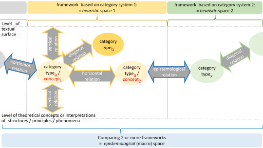
"The complexity and multi-layered nature of “topos” as a category, historically going back to antiquity, provides an opportunity to systematize the interdependencies between categorial elements in the concrete research design. The starting point was the “relationality” of topoi – i.e. the assumptions that a topos needs to be (re)constructed in relation to other topos concepts and that the category “topos” should be defined in relation to other categories. The basic principles observable in this specific context of the development and application of categories are transferable to other contexts. The paper proposes a typology differentiating vertical, horizontal, heuristic and episte"
"A decision in designing the conceptual model is that categories and categorial relations can be organized within a heuristic space. [...] The heuristic space consists of three axes: In addition to the vertical and horizontal relations, there is the diagonal relation between categories that do not belong to the same class. [...] Another important conceptual distinction of the spatial model are three different levels: The level of the textual surface refers directly to the object of investigation, e.g. a text corpus. On the opposite side lies a deep structure, which represents the level of theoretical concepts or interpretations of the realm of phenomena. In the middle or in the space in between, categories and concepts operate, building a bridge between the other two levels."
Maria Hinzmann: Categorial Relations in (Re)constructing Topoi and in (Re)modeling Topology as a Methodology: Vertical, horizontal, heuristic and epistemological interdependencies. Digital Humanities Quarterly Volume 17 Number 3 2023
---------------------------------
Cut zurück zur anderen Notiz über Dietmar Dath's Topologie
---------------------------------

Dietmar Dath - Neptunation. 2019
Über Topologien, und Netzwerke in der digitalen Kunstgeschichte:
Wenn seit Emmy Noether die Kartierungen Teil der mathematischen Forschung sind (vgl. Lee, C. (2013) Emmy Noether, Maria Goeppert Mayer, and their Cyborgian Counter-parts: Triangulating Mathematical-Theoretical Physics, Feminist Science Studies, and Feminist Science Fiction), bis hin zu Maryam Mirzakhani (in Dietmar Daths Nachruferzählung und in der Raumerzählung “Du bist mir gleich” wird das was diese Mathematik mit dem Denken macht in seiner Tragik und transformativen Kraft spürbar), dann ist das was die Netzwerk-Coder (z.B. Fan/Gao/Luo (2007) “Hierarchical classication for automatic image annotation”, Eler/Nakazaki/Paulovich/Santos/Andery/Oliveira/Neto/Minghim (2009) “Visual analysis of image collections”) und Google Arts & Culture in die digitale Kunstwissenschaft eingeführt haben, man kann es nicht anders sagen, das Gegenteil von all dem. Unhinterfragte Kategorien und unhinterfragte konzeptuelle Graphen (also sowohl Lattice Theorie, als auch Topologie ignorierend), werden ohne Binaritäten oder Äquivalente einfach als gerichtete Graphen, entweder strukturiert von den alten Ordnungen, oder, das soll dann das neue sein, als Mapping von visueller Ähnlichkeit gezeigt (vgl. die Umap Projekte von Google oder das was die Staatlichen Museen als Visualisierungs-Baustein in der neuen Version ihrer online Sammlung veröffentlicht haben). Wenn dann das Met Museum mit Microsoft und Wikimedia kooperiert, um die Kontexte durch ein Bündnis von menschlicher und künstlicher Intelligenz zu erweitern - nämlich Crowdsourcing im Tagging, und algorithmisches Automatisieren der Anwendung der Tags, dann fehlen einfach die radikalen Mathematiker*innen, die diese Technologien mit dem Implex der Museumskritik verbinden können, um ein Topos-Coding durchzuführen, das die Kraft hätte den Raum des Sammelns zu transformieren, so das nichts mehr das Gleiche bliebe. Während die heutigen Code-Künstler*innen großteils im Rausch der KI-Industrie baden, bleiben es einzelne, wie Nora Al-Badri (“any form of (techno)heritage is (data) fiction”), die zum Beispiel in Allianz mit einer marxistischen Kunsthistorikerin die Lektüre des Latent Space gegen das Sammeln wenden (Nora Al-Badri, Wendy M. K. Shaw: Babylonian Vision), und so Institutional Critique digitalisieren.
“Was Künstlerinnen und Künstler seit Erfindung der »Institutional Critique«, deren früher erster Blüte auch einige der besten Arbeiten von Broodthaers angehörten, an Interventionen in die besagten Räume getragen und dort gezündet haben, von neomarxistischer, feministischer, postkolonialer, medienkritischer, queerer Seite und aus unzähligen anderen Affekten und Gedanken, die sich eben nicht allesamt auf eine Adorno’sche »Allergie« wider das Gegebene reduzieren lassen, sondern oft auch aus einer Faszination durch dieses, einer Verstrickung in sein Wesen und Wirken geprägt war, liegt in Archiven bereit, die ausgedehnter und zugänglicher sind als je zuvor in der Bildgeschichte. Den Tauschwert dieser Spuren bestimmen allerorten die Lichtmächte. Ihr Gebrauchswert ist weithin unbestimmt. Man sollte anfangen, das zu ändern.” Dietmar Dath Sturz durch das Prisma. In: Lichtmächte. Kino – Museum – Galerie – Öffentlichkeit, 2013. S. 45 – 70
0 notes
Link
You had me at Wardley Mapping and Team Topologies
0 notes
Photo
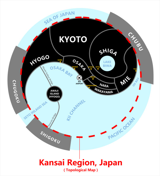
Topological Map of Kansai Region, Japan
by BerryBlue_BlueBerry
Lake Biwa and Awaji Island has similar shape and size, which make Kansai look like a yinyang symbol to me.
196 notes
·
View notes
Text
The Crucial Importance of Network Traffic Classification for Optimizing Connectivity
Greetings from Solana Networks, the leading source for state-of-the-art Network Traffic Classification solutions. With the ability to discern between dangerous and benign actions, our sophisticated algorithms carefully examine data flows and provide organisations with insights never before possible. We ensure optimal performance and security by decoding complex network behaviours with our cutting-edge technologies. Solana Networks offers customised solutions that are suited to your requirements, whether your goals are seamless network management, threat detection, or compliance adherence. Put your trust in our experience to protect your digital infrastructure from changing threats, increase productivity, and streamline operations. With Solana Networks, discover the possibilities of network intelligence in the future.
Phone: 613-596-2557
E-mail: [email protected]
#Network Traffic Classification#Network Topology Tools#Network Discovery Tools#Network Mapping#Network Topology#Route Analytics#Network Topology Tool#Network Topology Discovery#Network Discovery#Network Discovery Solution#Network Mapping Solution#Network Traffic Monitoring Solution#Network Traffic Monitoring#Lawful Intercept#Encrypted Traffic Classification#Encrypted Network Traffic Classification#Encrypted Traffic Intelligence#Security Machine Learning#Anomaly Detection#Cyber Threat Monitoring#Ddos Attack#Network Security Monitoring#Scada Security#Threat And Risk Assessment#Vulnerability Assessment#Network Troubleshooting
0 notes
Photo

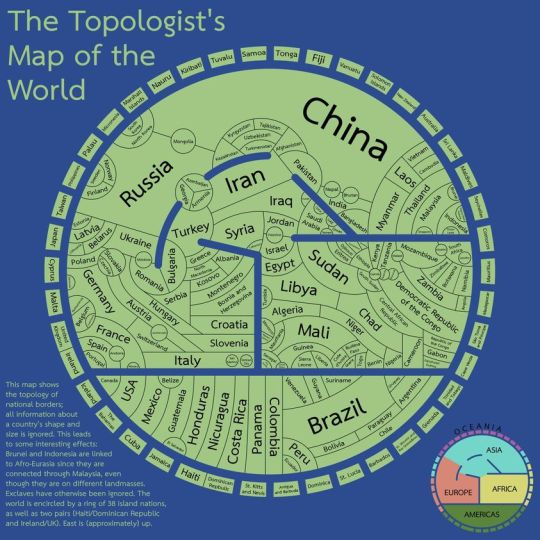
Topologist’s map of the world, by Tom Comerford
1 note
·
View note
Text
This is great!
"The topologist's world map"
0 notes
Text
i was gonna make fun of physicists for the whole 'spherical cow' thing but then realized that topologists consider a mug and a torus as the same thing.
Like yes, thinking that a cow is a sphere is weird until you realize that it's done out of necessity to reduce objects down to their simpliest forms. But thinking that a mug and a torus are equivalent just because they both have one hole in them is even weirder.
#ramblings#listen i just think that maybe topology as a whole could be less confusing#for example: why aren't closed sets the opposite of open sets???#like how r u gonna sit here and tell me that something can be both 'closed' AND 'open' at the same time???#the only time it ever makes sense is if you think of closed sets as a complement to open sets#anyways I've been reading some math books recently and topology as a whole is just so... confusing lol#i literally understand nothing. the first few topics that ive learned are kind of obvious (Jordan's Curve Theorem and Map Coloring)#then i get to set theory and it's all down hill from there#like I've been rereading the same five pages for three days now and still don't know what any of it means 😭
1 note
·
View note
Note
Hello I am going on a holiday to Eryri next month & I like to read up about an area before going there... do u have any reading or documentary or podcast recs? I'm particularly interested in the ecology & minority language activism & like. Peoples history & rural lives! I know this is stuff u know about in Wales but idk if north Wales is ur region! Míle buiochas ón Eireann!
Fáilte go dtí an Bhreatain Bheag! Or croeso i Gymru. Exciting! Keep an eye on the notes for others chiming in with good recs for documentaries and the like, I'm going to just give a super quick guide
Okay, pronunciation guide for place names and that is here in written form and here in video form. I cannot recommend strongly enough that you try to use the Welsh place names rather than the English translations. Duolingo is flawed but serviceable if you want to hear and learn some basic phrases. If you can at least throw out a 'bore da' to people you pass/shopkeepers, you'll be very well liked. You don't need to be fluent by any means, but Making An Effort is seen as, like, the nicest and politest and most wonderful thing in Wales, and particularly in regions like Eryri.
Because! It's one of the biggest remaining Welsh language strongholds. If you look at language maps over time in Wales, a pattern emerges:
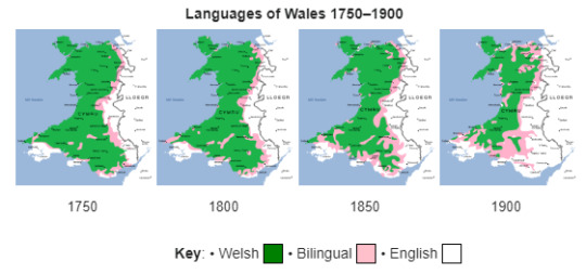
And the current (2021) figures show this:
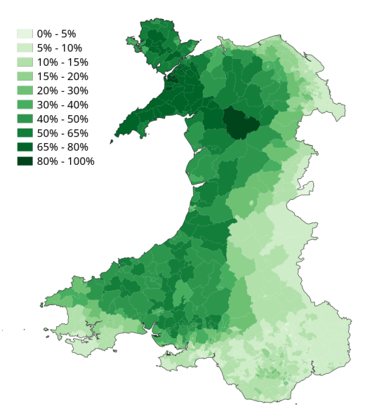
And you are going to this bit:
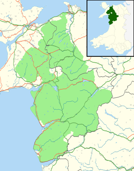
So you're heading into the Welshest bit in all of Wales! And the bit with the strongest and longest history of Welsh, too.
Which also means there's a lot of activism-related stuff in that area. It's probably worth you reading up on the history of Tryweryn (which was a bit further east, but sets the scene well); there was also a BIG thing a couple of decades ago where activists would burn down English-owned holiday homes (while they were empty in winter, not, like, with the English in them). This is because, in addition to the usual issues with the social impacts of holiday homes (driving up prices meaning locals can't live there, eroding communities, etc), holiday homes in Welsh language heartlands are a significant and tangible threat to the language. Even today, the issue of holiday homes is an extremely touchy subject, as is the issue of (mostly-English) people moving into the area because "It's so pretty!!!" and then not learning the language.
(Yet another reason they will love you if you Make An Effort)
Historically speaking, you'll be in a chunk of the country that was the ancestral seat of the last kings of Wales (Gwynedd). The final one, Llywelyn ein Llyw Olaf, was ambushed and murdered in 1282, which was the beginning of the end for fighting off English rule. In fact, Owain Glyndŵr later crowned himself king of Wales for about two years, but weirdly, no one acknowledges this as real kingship for some reason - if you google his name, he's always listed as a soldier or military commander, which really opens up a whole "Who gets to say when someone is royalty" debate, but he did actually claim descent from the House of Aberffraw anyway, so ultimately it still links back to Llywelyn.
Ecology! Temperate alpine. There actually isn't a global scientific distinction between hill and mountain, but most countries set an arbitrary height standard. This means it varies from country to country depending on how tall their topology is. Wales, however, bucks this trend, and instead decides based on what is formally referred to as 'land use' and colloquially referred to as 'Vibes'. If it's a hill, it's tamed - if it's a mountain, it's wild. This means Eryri is fairly short by the standards of tedious foreigners who regard mountains as a sort of geological dick waving competition, but it's in fact a whole mountain range; it's also older than Saturn's rings. And, crucially, it's very much sufficiently above sea level to have an alpine ecosystem.
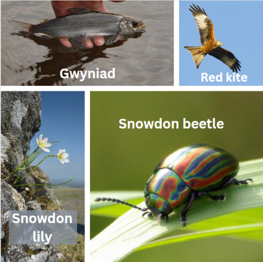
There are three endemic (i.e. not occurring anywhere else in the world) species in Eryri, to whit:
The Snowdon lily. A small and delicate flower growing in protected and inaccessible spots on yr Wyddfa (formally known as Snowdon). Excessively vulnerable to trampling, so the national park keeps sections where it grows fenced off.
The Snowdon beetle. RAINBOW BEETLE.
The gwyniad. A sub-species of whitefish until recently exclusively found in Llyn Tegid (Bala Lake), trapped there after the ice age and now developing its own genetic profile distinct from other whitefish. Some dickhead in the 80s introduced the ruffe to the lake for fishing, and the ruffe eats the gwyniad's eggs, so they've now transplanted eggs to Llyn Arenig Fawr nearby as a conservation measure.
There's also feral goats. And Welsh mountain ponies. Ooh, and, red kites - in the UK red kites were so heavily persecuted they eventually fell to just 7 breeding pairs in Wales. We established a protected zone and hired Nepalese Gurkhas to guard the nests and thus saved it from extirpation so successfully they later translocated Welsh birds to other spots in the UK. It's a big conservation success story, and now red kites are considered to be the national bird of Wales. They have a very distinctive silhouette, too, look for the forked tail.
Oh, and, we have a unique habitat type called ffridd, which you see a lot of in Eryri.
Final wildlife pictures to close:
Anyway - have a great time! Enjoy muchly.
287 notes
·
View notes
Last Seen Blogs

b2utyboargk
Untitled

dasleben-istein-wunderwerk
Always be happy!
katiesphotos716-blog
katie

crovewuzhere
CroveWuzHere

apolinariosmabini
now @freddieaguilarstillslaps