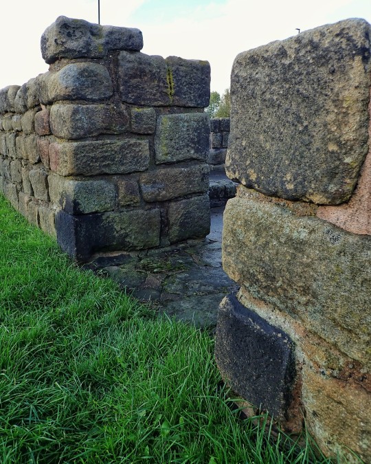
#roman milecastle
Text


Poltross Burn Roman Milecastle, Hadrian's Wall, Cumbria
#roman#roman milecastle#hadrian's wall#archaeology#romans#roman army#roman ruins#roman living#roman empire#landscape#stonework#ancient living#outdoors#wild places#poltross burn milecastle
223 notes
·
View notes
Text
Hadrian's Wall
The emperor Hadrian visited Britannia in AD 122 and ordered his generals to build a wall from the Tyne to the Solway, to prevent raiders from the north destroying the strategic Roman base at Corbridge, in Northumberland.
Hadrian’s Wall was 80 Roman miles long - about 73 modern miles or 117 km. It was built in 5 mile stretches, with seventeen forts. Smaller forts called ‘milecastles’ were built every mile and between these were signal turrets.
Building the wall was a huge undertaking; it took 15 years to build, and sons followed fathers into guarding the wall. Eighteen thousand soldiers worked on it, and 4 million tonnes of stone were used. It served as a frontier for several Roman incursions into Caledonia.
Much of Hadrian's Wall was about 10 Roman feet wide - 3m or 9.7 modern feet. It stood about 5 to 6 metres tall (16 to 20 feet). It was about a third wider at the base than it was at the ramparts.
By AD 367 the wall was attacked by an alliance of tribes as part of the ‘Barbarian Conspiracy’. The Roman peace – ‘Pax Romana’ - was restored for a short time, but by AD 400 the Empire which had stretched from Newcastle to the Nile was in crisis and the frontier was abandoned.
#Hadrian's Wall#history#Britannia#Great Britain#Romans#Roman empire#roman era#tribes#romans#pax romana
16 notes
·
View notes
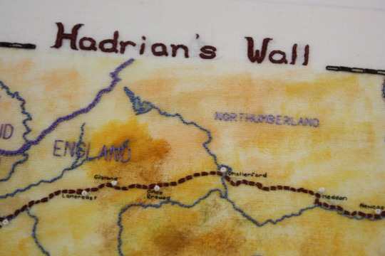
Photo
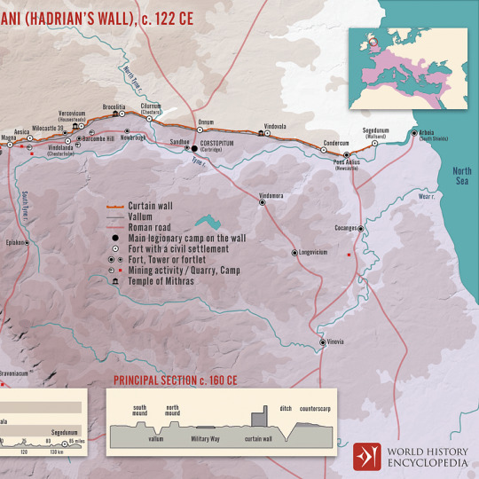
Vallum Hadriani (Hadrian’s wall), c. 122 CE
A map illustrating the span, structure, and context of the 73 miles (118 km) Hadrian's Wall (also called the Vallum Aelii, Aelius being the family name of emperor Hadrian). Built by a force of more than 15,000 soldiers from the three roman legions stationed in Britain, with an intent "to separate the Romans from the barbarians" (the Picts and other tribes to the north of Britain), the wall defined the northern frontier of the Roman Empire along the Tyne–Solway isthmus and created a military zone full of forts, milecastles, ramparts, roads, barracks and bustling settlements from the North Sea to the Irish Sea.
51 notes
·
View notes
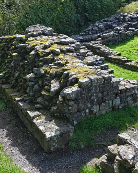
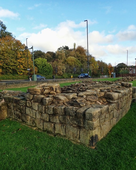
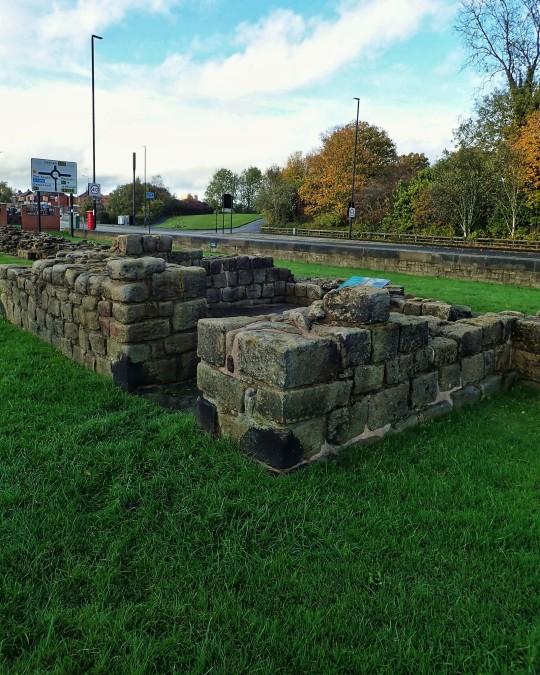
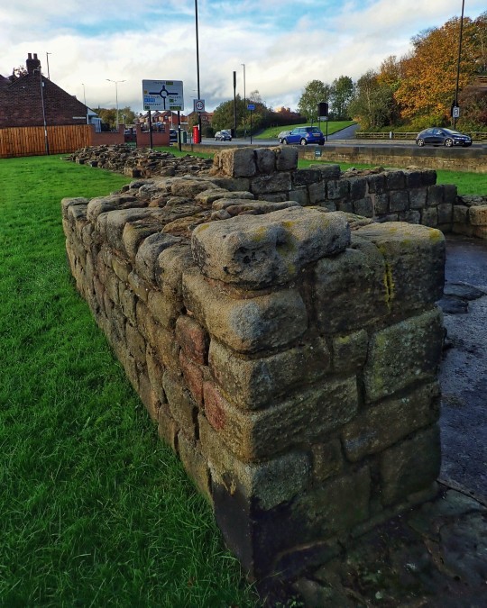
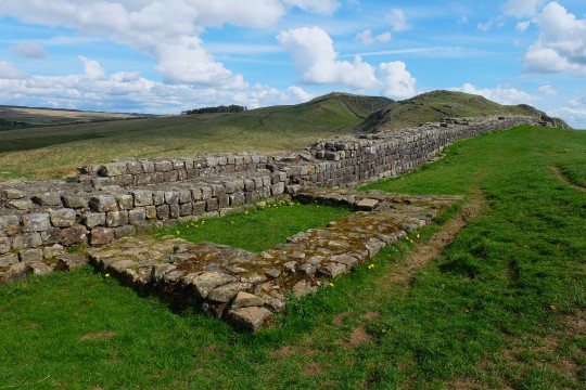
Text
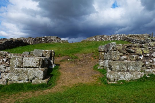


Cawfields Milecastle on Hadrian's Wall dated to the 2nd Century CE in England
The Roman army incorporated small forts in Hadrian's Wall, approsimately every Roman mile (about 1.48 km). These milecastle had gateways through the wall, enabling soldiers to control the passage of people to and from the Roman province of Britannia, and to allow patrols beyond the frontier.
Cawfields milecastle occpies steeply sloping ground at a strategic position overlooking Hole Gap. Here, the wall crosses a small area of flat ground in Cawfields Crags, a potential weak spot where intruders might otherwise pass over the wall unseen.
Each Milecastle varied a little in shape, size and constructional details, especially in the design of the gates. It is estimated that a milecastle garrison might contain as afew as 10 or as many as 30 soldiers, in one or two buildings. Although no traces of internal buildings remain at Cawfields, the walls and gateways are well preserved.
Photographs taken by myself 2022
#archaeology#military history#roman empire#2nd century#ancient#england#english#hadrian's wall#barbucomedie
23 notes
·
View notes
Text
Wed July 12
Took an excursion to Hadrian’s Wall and Housesteads Fort (Vercovicium) today. This was an incredible experience, and our guide was fantastic! He made life as a Roman soldier at this place 1900 years ago come alive, with an added touch of humor. This is sure to be a favorite memory after our big trip is over. The hilltop gave expansive views both to the north and the south, and the short walk on the Wall itself to Milecastle 37 was really special. Even the weather was cooperative, after rain on the coach journey. Upon return to Durham, sang another Evensong in the Cathedral, and had another group dinner. What a great day!
2 notes
·
View notes
Text
The Vallum

The Vallum is a huge earthwork associated with Hadrian's Wall in England. Unique on any Roman frontier, it runs practically from coast to coast to the south of the wall. I first heard of it reading an old Prince Valiant Comic Strip September 20 1942 "One Day Val Encounters a huge ditch extending over hill and valley as far as the eye can reach. He is puzzled, in fact, to this day people are wondering why the Romans dug the "Vallum." " Harold R Foster. Makes me wonder if Hal Foster actually visited the sites where he set his great Comic Strip. He certainly did a lot of research for his strip.
Before the middle of the 19th century, the Vallum was most commonly known as Agricola's Ditch, since antiquarians wrongly thought that it had been constructed during the period when Agricola was Governor of Britannia, the Roman province spanning what is now England, Wales and southern Scotland. After John Hodgson published the final portion of his History of Northumberland in 1840, it became generally accepted that the Wall and Vallum had been built during the reign of Hadrian. Hodgson based his view on evidence which included a stone tablet now in the Great North Museum: Hancock, Newcastle upon Tyne, which had been found in Milecastle 38 on the Wall in the previous century, its significance having been overlooked. The inscription on the tablet, probably made and erected to mark the completion of the milecastle, includes the names of Hadrian and Aulus Platorius Nepos (Governor of Britannia during Hadrian's reign), as well as "Legio II Augusta" (Second Augustan Legion). It is now accepted that units of that Roman legion built the section of Hadrian's Wall which includes the milecastle, and they would have automatically included the names of the current emperor and governor on the tablet.
The Vallum is known to have been constructed some time after the wall was completed, as it deviates to the south around several wall-forts which were either completed or under construction when the wall was nearing completion. There would have been a crossing-point like a causeway or bridge to the south of each wall-fort – several such causeways are known, such as the one still visible with the base of an ornate arch at the fort of Condercum in Benwell, a western suburb of Newcastle. Causeways have also been detected to the south of several milecastles.
0 notes
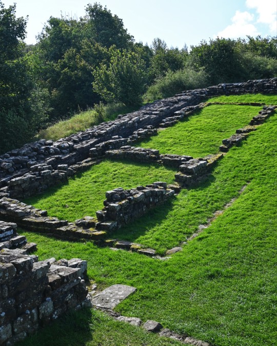
Text
Wiktionary's word of the day: 22nd October 2022
milecastle:
One of a series of small rectangular fortifications, spaced roughly one
Roman mile apart, built during the period of the Roman Empire.
https://en.wiktionary.org/wiki/milecastle
0 notes
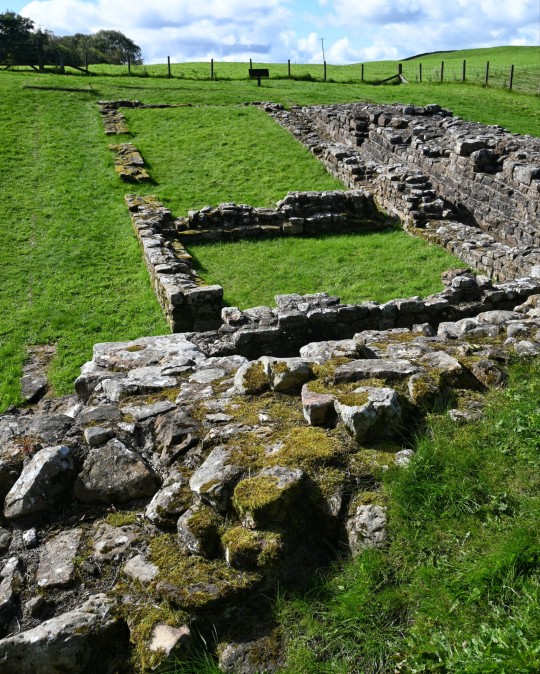
Photo
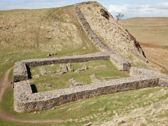
Milecastle 39 on Hadrian's Wall (Northumberland, England).
Milecastles were small Roman forts, placed at intervals of about one Roman mile along several major frontiers.
#history#classics#military history#colonialism#architecture#roman conquest of britain#roman architecture#britain#ancient rome#roman britain#england#northumberland#hadrian's wall#milecastle 39#milecastles
296 notes
·
View notes
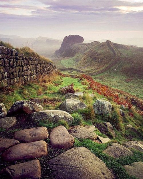
Photo
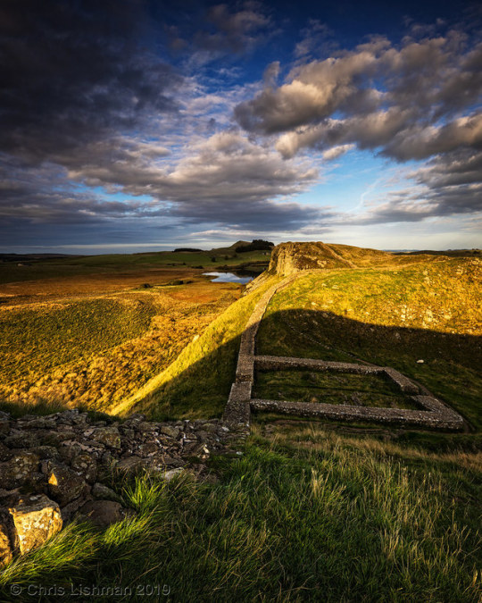
Milecastle 39 Vertorama by Chris Lishman A pleasant wander up to Hadrian's Wall this evening and some nice early evening light painting the landscape. . Original: https://www.flickr.com/photos/34845751@N05/48750832743
#hadrianswall#northumberland#hadrian#roman#romanwall#england#uk#history#milecastle#milecastle39#craglough#wall#lake#landscape#vertorama#leefilters#tiltandshift
1 note
·
View note
Photo

8 notes
·
View notes
Text


Ancient Ruins As They Would Have Looked In Their Prime
Duncan Madden
I write topical, environmental and experiential travel stories.
From the unmatched wonder of Cambodia’s Angkor Wat to the sprawling majesty of the temples of Bagan in Myanmar (aka Burma). From Egypt’s Great Sphinx of Giza to the extraordinary carved city of Petra in Jordan. These remnants of the ancient world have long cast a spell over travelers from every corner of the globe.
In fact, a quick check of any ‘most popular tourist attractions in the world’ list (note attractions, not cities) will likely throw up more ancient man-made sites than modern attractions or natural wonders, with Machu Picchu, the Great Wall of China, the Acropolis and Rome’s Colosseum regular contenders for the top spot.
People’s interest is clear. We’ve long been fascinated by our past as and how it shapes our future – how people lived, what technologies they had, what their homes and public spaces looked like and just how they built these extraordinary edifices without modern machinery.
But it’s often tough to really get a sense of what these ancient buildings would have looked like in their heyday - many were resplendent in gold and other finery, intricately carved and finished with elements no modern tourist can ever see and would struggle to imagine.
Now though, with a little creativity and some help from the technical, historical and architectural experts at Expedia, we can see what seven of the great ancient ruins of the world would have looked like to those who lived with them at their peak. Enjoy.
The Parthenon -The Parthenon, then and now.
Casting views from the hilltop at the Acropolis citadel in Athens, Greece, the Parthenon is a true ancient wonder whose Doric architecture has been ravaged by time and war. Its cavernous halls once held a huge golden statue of Athena, the Greek goddess of wisdom, craft and (ironically) war.
Nohoch Mul Pyramid, Cobá - Original colors and details shine a new light on Nohoch Mul.
The Mayans built some amazing stuff before the Spanish conquistadors spoiled the party, with pyramids to rival those of Egypt. Cobá, set deep and remote in the Mexican state of Quintana Roo, was settled some time between 100 BC and 100 AD and occupied right up until 1550. Amid the thick jungle, extraordinary caves and natural pools are dotted many temples, with Nohoch Mul the tallest at 137 feet. Rediscovered in the 1800s and only accessible to the public since 1973, it remains one of the most extraordinary insights into the tenacity of ancient humans to leave their mark anywhere in the world.
Temple of Jupiter - From a few broken columns to its original splendor, the Temple of Jupiter.
As its name suggests, this temple was built in honour of Jupiter, the Roman god of sky and thunder, on the Bay of Naples in a thriving city called Pompeii. Modern man may think they didn’t do a good enough job though, as it was buried beneath the wrath of nearby Mount Vesuvius in 79AD in what remains the most famous volcanic eruption in history. Rediscovered in the 16th century, it took many years of excavation to uncover its limited remains.
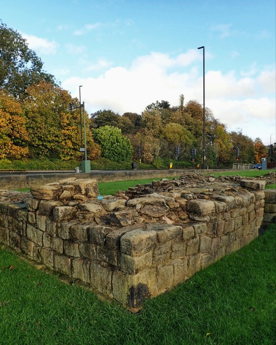
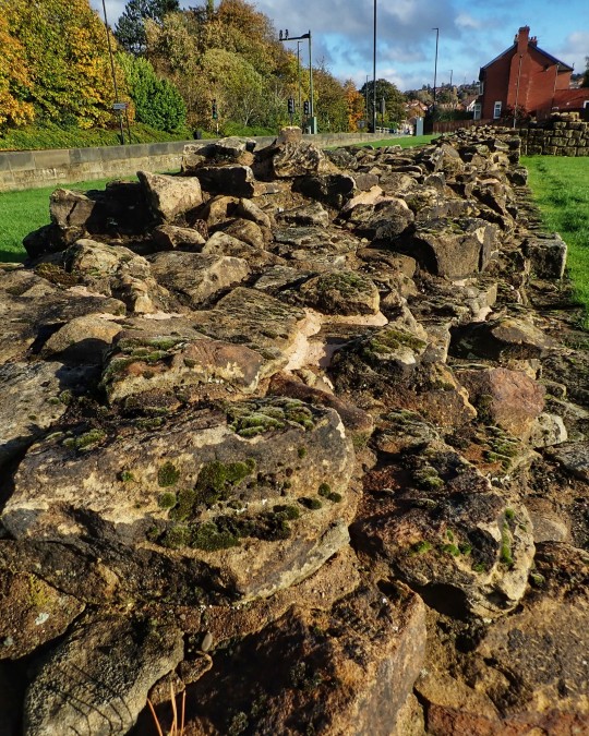
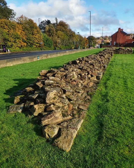
Milecastle 39, Hadrian’s Wall - Little more than foundations now, Milecastle 39 was once a Roman stronghold.
Britain’s lesser known ‘great wall’ was a monumental Roman achievement - 73 miles of border cut through the English countryside dating back to the first century AD. Built (we think) to secure Roman Emperor Hadrian’s grip on the island nation and its pesky inhabitants, it had forts known as Milecastles built at each Roman mile along its length. All but gone now, this gives us a glimpse into how they would have looked.
Luxor Temple - The famed Luxor Temple returning to its original glory.
One of the most recognisable names connected to ancient architecture, Luxor takes its name from the Arabic for fortification – al-Uqsur – and has been a sacred site since its commission in 1380BC by Amenhotep III. It was renovated and updated a century later by Rameses II who added a great pylon gateway and courtyard, connected to the nearby Karnak Temple by an avenue of sphinxes to guard it. An iconic structure in a country filled with them.
The Pyramid of the Sun, Teotihuacán - This virtual renovation shows the true scale of the original Pyramid of the Sun.
A genuine modern day mystery, we know Teotihuacán was one of Mexico’s first urban centres sometime between the first and seventh centuries CE but we don’t know much about who built it or who lived there. Of its many extraordinary and mysterious structures, The Pyramid of the Sun is by far the largest – an ancient, man-made mountain.
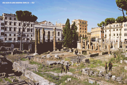
Temple B, Area Sacra di Largo Argentina - Temple B – more impressive than its name suggests.
Built in Italy not Argentina as the name may suggest, this gorgeous central Roman square once housed four exquisite temples. The most recently discovered (and least romantically named) Temple B was found in the 1920s and still has six columns and the original steps and altar intact. Perhaps most famous as the place where Julius Caesar uttered his immortal accusation, ‘Et tu, Bruté?’, as he was stabbed to death, it’s one of the lesser known but more remarkable sites from the Roman civilization, and isn’t often open to visitors.
see what seven of the great ancient ruins of the world would have looked like to those who lived with them at their peak. Enjoy.
10 notes
·
View notes
Text


Denton Hall Turret, Hadrian's Wall, Newcastle upon Tyne
#roman#roman army#roman living#romans#roman empire#roman soldiers#hadrian's wall#roman building#turret#roman milecastle#archaeology#ancient sites#ancient cultures#ancient craft#Newcastle
119 notes
·
View notes
Photo


Hadrian’s Wall, Brampton featuring Hadrian’s wall, Birdoswald Roman Fort and Harrowscar milecastle and wall.
This section of Hadrian’s wall is one of the best preserved and it’s incredible. With just a short walk you can appreciate the scale of Hadrian’s wall, and see the remains of Birdoswald Roman Fort and Harrowscar milecastle. Pretty great way to start the day. -RoxyC
Ok, *spolier alert*, my Uncle took me here a few years back. So naturally I had to bring my wife as I found it such a great location. Big up my Uncle Als showing me the way. Top geezer. -TommyC
Opening hours: Daylight hours.
Cost: Free
Visited 153-155/2781 on our travels….
https://www.tumblr.com/blog/adventuresoftommycandroxyc
CLICK HERE ->Check out this site on our adventure map <- CLICK HERE
#adventuresoftommycandroxyb#adventuresoftommycandroxyc#adventures#adeventureseeker#explore#goexplore#getoutstayout#gooutside#everybodyneedsnature#romanfort#birdoswaldromanfort#hadrian'swall#harrowscar#harrowscarmilecastle#romanwall#roman#archaeology#historicengland#englishheritage#givenatureahome#nature#naturelovers#digitalnomads#travel#travelblog#travelblogger#archaeologyblog#travelwithus#travelwithlove#newlyweds
1 note
·
View note
Photo

Milecastle 39 on Hadrian's Wall, Northumberland
#Britain#England#northumberland#Haltwhistle#hadrian's wall#Roman#roman ruins#defensive wall#milecastle#fortress
14 notes
·
View notes
Text
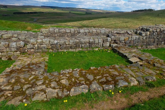
The Caw Gap of Hadrian's Wall dated to around 122 CE in England
This ruined stone foundation, labelled turret 41a, is the ground floor of a turret or watchtower built by Roman Legionary soldiers as part of Hadrian's Wall, from 122 CE. Originally, two turrets were placed between larger milecastles, which were built about one Roman mile apart (about 1.48 KM).
Although the floor area inside seems small, the turrt may have had two or perhaps three storeys and could have provided shelter or accomodation for troops who patrolled the frontier.
Not all turrets were maintained throughout the history of the Roman frontier, around CE 122-410. This one was demolished and th eWall was rebuilt over its site, probably as part of extensive alterations along the frontier due to the military campaigns north of the Wall by the Emperor Septimius Severus in CE 208-211.
Severus took a Roman army beyond the Wall in the early 3rd century to fight against the Caledones and Laetae, indigenous peoples of what is now Scotland.
Photographs taken by myself 2022
#archaeology#roman empire#2nd century#military history#ancient#hadrian's wall#england#english#barbucomedie
18 notes
·
View notes
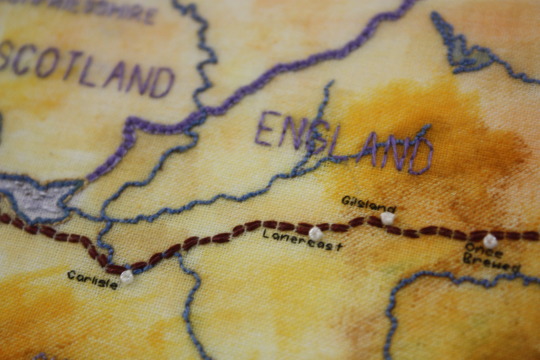
Text
Cheryl Berger
Novato, California
Hadrian's Wall
Back stitch, running stitch, paint, beads
“Hadrian's Wall was a defensive fortification in the Roman province of Brittania, begun in AD 122 by the Emperor Hadrian. The wall defined the north-west barrier of the Roman empire and stretched from coast to coast. It remained in active use for some 300 years, and was garrisoned with soldiers from across the Roman Empire. The remains of some of the milecastles and forts can still be seen today.”

1 note
·
View note
Last Seen Blogs

quorras
home of the tron (1982) deleted donut scene

bryanerik
sleeping in

shadowleedgehog
(sin)3.1415926535

ztu2455
Tu

malayangmundo
Malayang Mundo