#qlcs tornadoes
Text


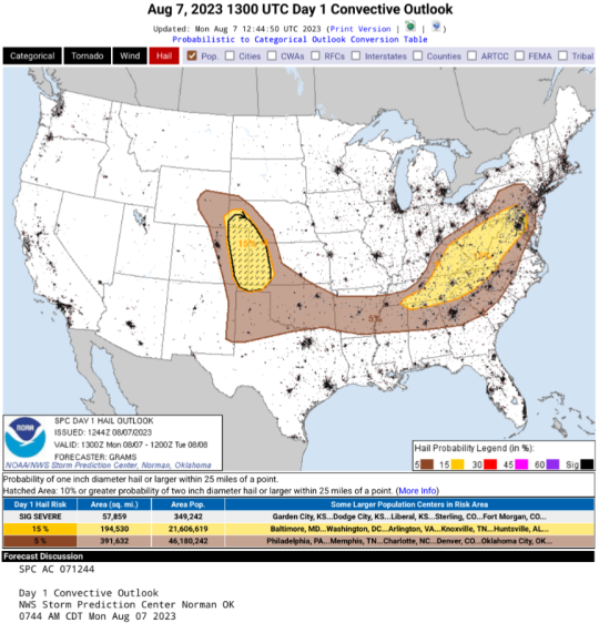
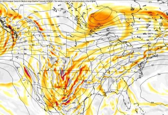
monday's weather forecast: hot today, transitioning to big-ass wall of holy shiiit this evening. wimdy tonight, then hot and clear skies tomorrow. wind will be blowing from the west, except where tornadoes. brace yourselves accordingly.
source: NOAA/NWS Storm Prediction Center
#weather forecast 2023 august 7#i'm in the red zone for wind#guess i'll fly away#noaa#national weather service#squall line#qlcs tornadoes#wind and hail
4 notes
·
View notes
Text
TOMORROW, 11/04/2022, IS A WEATHER AWARE DAY FOR DFW/NORTH TEXAS
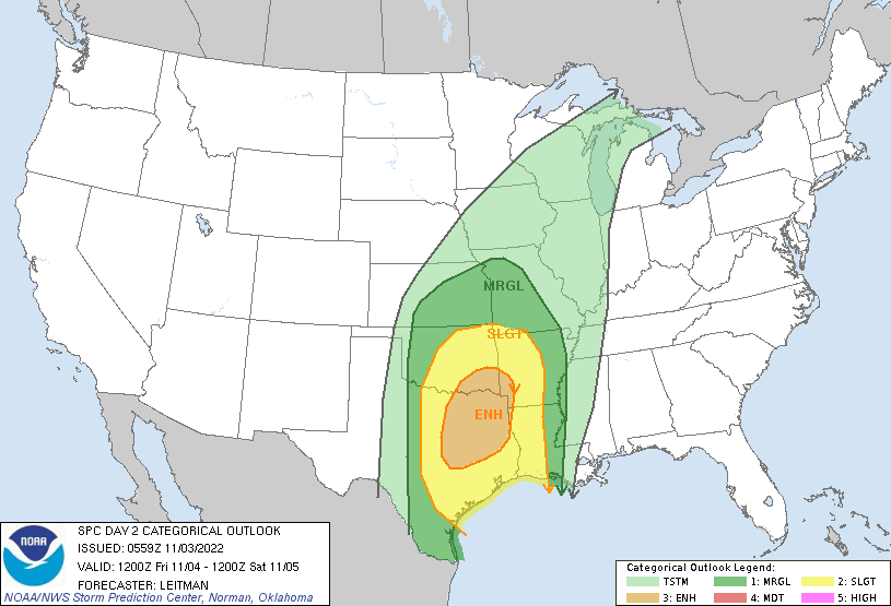
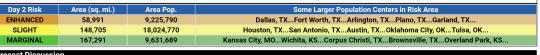
SPC AC 030559
Day 2 Convective Outlook
NWS Storm Prediction Center Norman OK
1259 AM CDT Thu Nov 03 2022
Valid 041200Z - 051200Z
...THERE IS AN ENHANCED RISK OF SEVERE THUNDERSTORMS ACROSS NORTHEAST TEXAS INTO SOUTHEAST OKLAHOMA AND FAR SOUTHWEST ARKANSAS...
...SUMMARY... Strong to severe thunderstorms are expected Friday into Friday night across portions of the southern and central Plains into portions of the Arklatex. Scattered damaging gusts, hail and a few tornadoes will be possible.
...Southern Plains into AR/LA and Vicinity...
A complex scenario for severe thunderstorm potential exists on Friday across parts of the southern Plains into the Arklatex vicinity. The large-scale pattern will be characterized by a potent upper shortwave trough centered over the Four Corners/southern Rockies vicinity Friday morning. As the trough ejects eastward toward the Plains, a closed low is expected to develop and an intense 80-100 kt south/southwesterly 500 mb jet will overspread portions of the southern Plains by evening. Meanwhile, strong warm advection will persist over the region on a 35-50 kt southerly 850 mb jet. This southerly low-level flow will transport rich boundary-layer moisture northward ahead of a cold front developing southeast across the central Plains the lower-MO/Upper MS valleys, and an eastward-advancing dryline across central/eastern TX. Mid/upper 60s F dewpoints are forecast ahead of the dryline across TX into southeast OK/southern AR and LA. Boundary-layer moisture will diminish with north/northeast extent ahead of the cold front, with low/mid 60s F dewpoints as far north as northeast OK/northern AR. Widespread cloud cover will limit surface heating. However, steepening midlevel lapse rates atop an unseasonably moist boundary-layer will support moderate destabilization, especially across TX where moisture quality will be best.
Thunderstorm clusters will likely be ongoing at the beginning of the period near the cold front from northwest OK into central KS. This initial activity will mainly be capable of hail and strong gusts as the surface cold front shifts southeast across KS and western OK. With time, warm sector convection is expected to develop in the vicinity of the I-35 corridor from south-central OK into north/central TX. Uncertainty remains regarding convective mode due to differences in guidance with the timing of surface boundaries and the ejecting upper trough. However, a mix of semi-discrete supercells and clusters/line segments initially appears possible beginning Friday afternoon. This activity will likely grow upscale into a QLCS across southeast OK/northeast TX toward western AR/LA. All severe hazards will be possible, including damaging gusts, hail, and a few tornadoes (a couple of which could be significant).
Of note continues to be differences in forecast guidance regarding the timing of the ejecting of an upper trough over the southern Rockies Friday morning. The ECMWF/GFS solutions are around 3-6 hours quicker with the eastward progression of this system compared to the NAM/HRRR/HREF/SREF. This also has implications for the evolution of the surface cold and the dryline. Given this uncertainty, in conjunction with latest guidance from various CAMS, HREF and the NCAR HRRR Neural Network Convective Hazards guidance, the Enhanced risk has been expanded westward toward the I-35 corridor in north/central TX.
..Leitman.. 11/03/2022
PTSDY2 PRODUCT NOTE: THE NEXT DAY 2 OUTLOOK IS SCHEDULED BY 1730Z
CURRENT UTC TIME: 1646Z (11:46AM)
3 notes
·
View notes
Text
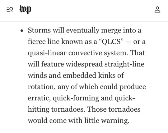
A cogent explanation of what QLCS tornadoes are, and what a menace they can be. This is from the Capital Weather Gang at the Washington Post.
0 notes
Text
Don’t reblog.
My county is in the enhanced, 30% hatch for all modes of severe weather (including strong, long lived QLCS tornadoes) for tomorrow...

#personal#pray for me y'all#i'm probably going to be sick with anxiety tomorrow#from the moment i wake up tomorrow morning#till it passes#i'm going to be on high alert#'stressful' or 'anxious' are mere understatements of how i'll be tomorrow
2 notes
·
View notes
Text
Severe Weather Heading for the Mid-South….Again
Although the last severe weather system that came through the region packed quite a punch, this system that will be causing a ruckus in the Dallas area today is a rare setup that, if it ever is evident, it won’t present itself until April or May. A setup like this in January is extremely uncommon and even seasoned meteorologists are concerned for what exactly this system will bring. What we know now? All modes of severe weather are possible across the ArkLaTex region, as well as Mississippi and Alabama.
Let’s start with the Dallas/Fort Worth area. An aggressive short-wave 500mb trough will be pushing out of New Mexico into Texas this morning. The jet streak within this trough is containing 80-90+ knot winds (90-100mph). Southerly flow will be rising from the Gulf throughout much of the Mid-South bringing in warm moist air, aiding in a lifting mechanism, warm air advection. Looking at HRRR and the Euro, supercell development should increase in the Oklahoma and eastern Texas region by mid-to-late afternoon. 0-3km lapse rates will be steep, nearing 8°C/km by early afternoon with MLCAPE slightly exceeding 1000 J/kg. Strong shear will also remain evident. HRRR showing a little more aggressive than the Euro with MLCAPE around 1700 J/kg and lapse rates nearing a staggering 9°C/km, with shear rates about the same. Dew points remain in the upper 60s, and precipitable water exceeding 1.5” in areas where supercell development is to be expected. Diabatic heating could also be a possibility near the DFW area, as cloud cover remains spotty. There is not a large cap, but if there’s enough sunlight with upper 60° dew points, that cap could be busted quickly, even furthering the severity of the cells that do form. As the system collects along the frontal boundary, supercells will become linear to form a QLCS (quasi-linear convective system or more commonly referred to as a squall line). A derecho event will also be probable with this line as it progresses into northern MS and eastern TN overnight tonight.
SPC issuing a moderate outlook for this region this afternoon was definitely needed. All the ingredients are there for an outbreak of severe weather across the area. All lifting mechanisms are present: warm air advection, positive vorticity advection, and diabatic heating. MLCAPE is marginal, with staggering lapse rates and shear values. Everyone in this area should be weather aware and have their safe place in mind, as long track tornadoes are not out of the question in this system.
As for the rest of the Mid-South, this system will be pushing through the area during the late overnight hours and into Saturday morning. This is particularly dangerous as there will also be a tornado threat overnight for MS and TN. SPC has stretched the Moderate Risk to include Memphis, TN, and Greenville, MS. Greenville will also be included in the 15% Tornado Probability area. Looking at HRRR at 8z (2 am CST) in Greenville, with around 30min to 1 hour before the line enters Greenville, MLCAPE is around 1200 J/kg with lapse rates hovering near 7°C/km and shear values comparable to those in the DFW area later this afternoon. Warm air advection is high, with tons of moisture through the southerly flow initiating from the Gulf, causing dew points in the upper 60s throughout the state with temps hovering around 70°. A stout low level jet is also in the region with winds measuring up to 80 knots (90+ mph) which will aid in tornadic development along the southern portion of the line as it will be more organized. Vorticity is maxed out along the frontal boundary as well. Diabatic heating won’t be an issue at this stage as this will be during the overnight hours.
As the trough approaches the region, the 500mb streak will increase to over 100 knots and the LLJ will max out between 60-70 knots. As the line progresses through the area, a significant bowing segment appears over northern MS and eastern TN, which could indicate a derecho as this bow continues into much of TN and Alabama through the morning hours of Saturday. The line should be moved out of the area by midday to early afternoon hours and with that, severity will diminish. The greatest threat for tornadoes and large hail remain to the south of Tupelo. However again, all modes of severe weather are possible throughout the state and into Alabama as all ingredients are there for tornadoes to develop within the region. Brief tornadoes cannot be ruled out in the Slight Risk and a rogue long-track tornado cannot be ruled out either in the Enhanced Risk. Staying weather aware is of the utmost importance this weekend with these storms. Expect gusty conditions and high profile vehicles should consider timing of their commute during the event. Straight line wind damage is also a very large possibility as some areas could experience wind gusts of over 70 mph.
After the line passes, cloud cover will decrease and temperatures will begin to cool down. Partly cloudy conditions are expected Sunday, with highs in the low 50s and increasing cloud cover into Sunday night.
0 notes
Text
What is Ghosting?

Why People Ghost and What To Do If It Happens To You
Tired of Getting Ghosted?
Dating is not easy. This is something I hear often in my work with quarterlife clients. They describe the ups and downs of dating, their nervousness on first dates, and doubts about whether the other person wants to see them again. In dating, you are consumed with questions like: Will we play games or can we cut through the bullshit and just be real with each other? Is there a future for us? Did I get too drunk? How soon can we have sex?
I’ve been hearing a lot about ghosting from clients lately. What is ghosting? It’s when the person you are dating abruptly disappears and stops texting (because, as I’ve been told, no one makes actual phone calls anymore). Ghosting often occurs after multiple dates, sometimes even after months of dating. A recent book of poetry written by Samantha Jayne entitled Quarterlife Poetry perfectly describes ghosting.
________________________________
“Our first date was magic
the next was okay
I texted for thirds
but he ghosted away…”
–Quarterlife Poetry By Samantha Jayne
_______________________________
Being ghosted is confusing and frustrating. It can result in a tornado of questions swirling in your head: “Where did she go?” “Did she get my text?” “What did I do wrong?” “How could I have misread this? “Did we have sex too soon?” You may find yourself speculating as to the reason for the sudden silence: “He may have lost his phone.” “Maybe she’s married and her husband found out.” “I hope he wasn’t in a terrible accident!”
So, Why Do People Ghost?
The answer is usually pretty simple. Ghosting is easier than having to tell you that they don’t want to continue to date you (or, perhaps, that they are ambivalent about dating you). Many people fear confrontation and think that being direct will hurt your feelings; so they avoid dealing with it at all. And they just slip away… like a ghost.
How Do I Handle Being Ghosted?
Acknowledge It.
If you’ve reached out and haven’t heard back from the other person, you might consider contacting them one more time to confirm that they received your text or message. If you still don’t hear back within several days, it is likely that you’ve been ghosted. You should MOVE ON and make your own plans –for this Saturday night, and your life. Don’t put your plans on hold while you wait to hear back from the other person.
Reflect on What Happened. Don’t Obsess.
Once you realize you’ve been ghosted, you will probably feel confused and will want to make sense of it.
Self-reflection is a good thing, but don’t get stuck in negative self-talk and obsessive thought patterns. It is important for you to understand what happened and why; but with the other person out of the picture you only have yourself to probe. That’s ok because you are not looking to assign blame, but rather to understand your own thoughts and behaviors. Ask yourself whether you could have seen this coming. Did you overlook red flags early on? Have you fallen into a pattern of pushing people away or dating people who don’t want a commitment? Were there specific conflicts that were brewing but were never addressed?
If you find that you’re obsessing about it, distract yourself with a fun activity or set time limits. For example, set a timer for 15 minutes, let yourself feel and think about the relationship as much as you can. But when the timer sounds, move on.
Remember: Although a post-hoc examination of the relationship might help you understand why you were ghosted, most of the time, the reason(s) won’t become clear. It’s quite possible that the ghosting had nothing to do with you or your behavior. Often people ghost because of something happening in their own lives.
Identify red flags.
Review the relationship to determine whether you overlooked red flags early on. Did the other person seem ambivalent about dating you? Were you the only one initiating communication and dates? Sometimes, people ignore signs of incompatibility because they want the relationship to continue.
Identifying warning signs from this relationship can help you acknowledge red flags, and deal with them, earlier on in your future relationships.
Get Closure.
Depending on how long you dated and the attachment you developed, you may feel a range of emotions like disappointment, surprise, and even betrayal. In order to achieve closure, you must acknowledge your feelings and give yourself some time to heal.
There are two ways to get closure:
intra-personally: within yourself (i.e., self-reflection, venting to friends, journaling), and
interpersonally: with the person who ghosted you (i.e., writing a note or text wishing the person well and saying goodbye).
Take Care of Yourself. And Move On.
Like I mentioned at the beginning of this post, move forward with your own plans. Don’t put your life on hold while you wait to hear from the other person.
About Quarterlife Center (QLC):
Our QLC Counselors specialize in working with individuals and couples in their 20s and 30s in a supportive, caring, confidential setting. We will work with you to help you identify your passions, achieve your goals and thrive in your life.
Quarterlife Center offers the following services to clients:
Individual Counseling
Couples Counseling
Premarital Counseling
Career Coaching
Perinatal/Postpartum Counseling
If you’d like more information or you’re interested in scheduling an appointment, please contact.
0 notes
Text
Severe Weather Threatens the SE Again
The tricky part of the Wednesday forecast is that many students will be driving back home for the Easter Holiday, and most of the state of MS will be impacted by some form of severe weather.
April 17th, 2019 (evening) and April 20th, 2019
Wednesday Thoughts
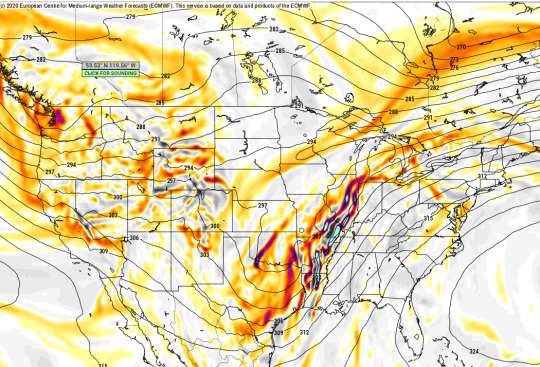
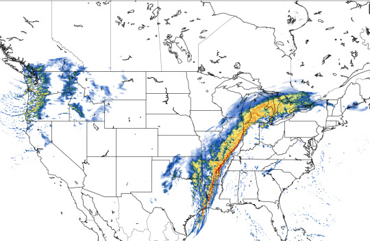
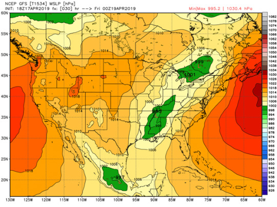
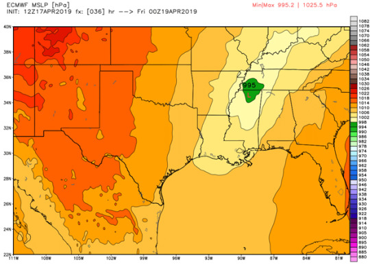
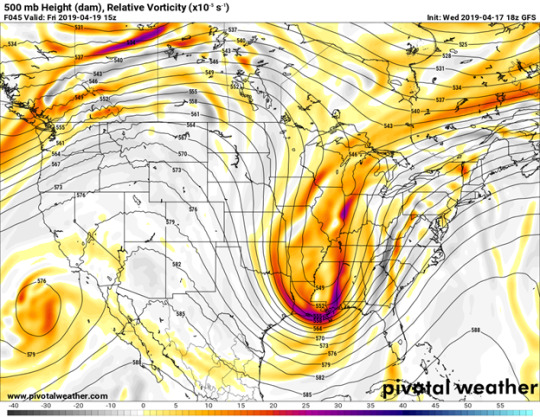
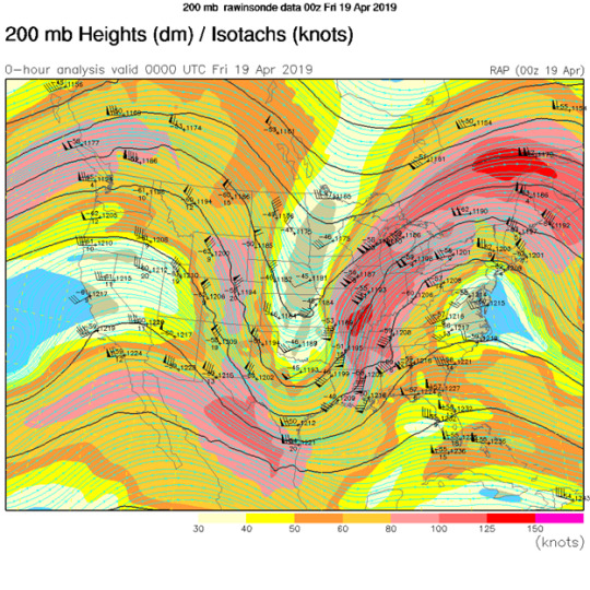
There is currently an upper level trough lifting out of the great plains region that brought severe weather to portions of Oklahoma and north Texas today. The NWS in Jackson put into works better than I ever could, the process behind the formation of the secondary low that will bring severe weather to the southeast tomorrow: “Lee side cyclogenesis will occur over the High Plains with the main low lifting northeast into the upper Midwest by tomorrow morning with an attendant cold front draped through the Mississippi River Valley. A perturbation propagating along the frontal boundary over east Texas will help induce a second area of cyclogenesis beneath favorable upper jet dynamics with a deepening low (~995mb) lifting through southern Arkansas into far northern Mississippi through the day tomorrow.” The surface low is expected to deepen as it moves northeast through north Mississippi. A deepening low moving this far south puts south Mississippi and southeast Louisiana in the prime region for dynamics that support a severe weather threat. The 500mb vorticity is very impressive with this low. Most of the upper levels look rather impressive, the only thing that could limit the setup in my opinion is on the mesoscale.
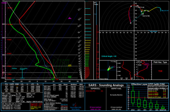
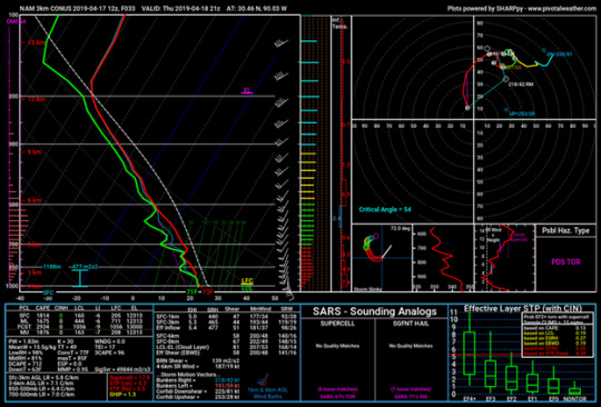
The CAM models are on board for significant severe weather tomorrow. The updraft helicity values on the 3km NAM show rotating updrafts through central to south Louisiana all the way though central Mississippi. CAPE values are not shocking, but they are sufficient enough for severe weather in the 1500J/kg – 2000J/kg range. The most favorable part of this set up is the shear. Surface winds are coming from the southeast, which means impressive turning in the low levels. The image below is a forecast sounding from the 3km NAM taken from southeast Louisiana showing quite the impressive hodograph (especially for southeast Louisiana). If there is no large MCS/prefrontal convection, we could see some supercell activity ahead of the line. My bets are on Hattiesburg for the likeliness of seeing the strongest storms.
A Look Back (Written on Saturday)
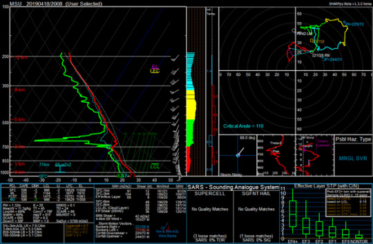
An impressive trough dug to the deep south on Thursday. As seen on a 200mb analysis map, 125kt winds were found over the state of Mississippi at 0z Friday, right as the line was passing through northeast Mississippi. The sounding below is from Starkville, MS at 21z on Thursday, right before the flash flooding occurred. Starkville is well above average for rainfall this year so far, so intense amounts of rain in a short time period was problematic. (Notice the veering and then backing winds).
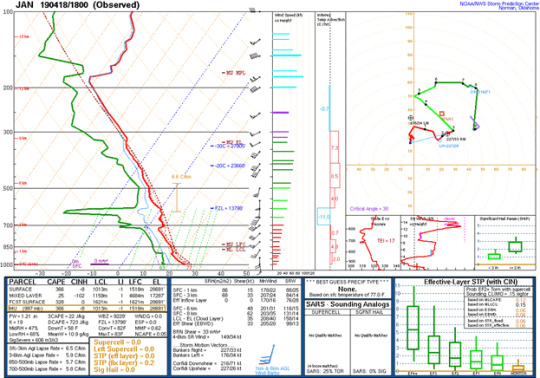
Multiple tornadoes were reported in the central part of the state near Jackson, MS during the mid part of the day on Thursday. The tornadoes were embedded within a large QLCS tracking across the state. The sounding below is taken from Jackson at 18z Thursday, shortly before the tornadoes occurred. One interesting aspect of the sounding in the veering winds at the surface with backing winds about 100mb above that. This type of wind profile was seen on models days before this event and was even more evident further north in the Starkville soundings. I’m not sure what effect this wind profile had on the event, but I thought it was interesting to note – this could be something important for future tornadogensis research. There also was not much CAPE in the Jackson sounding, but the temperature and humidity profiles were similar to what is seen during large QLCS events.
As this trough began to lift out of the southeast, it continued to bring severe weather along the east coast. A moderate risk was issued for parts of Virginia and North Caroline, which does not happen often. The risk verified rather well, with a large number of damaging wind reports and extensive damage reports.
0 notes
Text
SBW19 and Severe Weather: Not a Great Combo
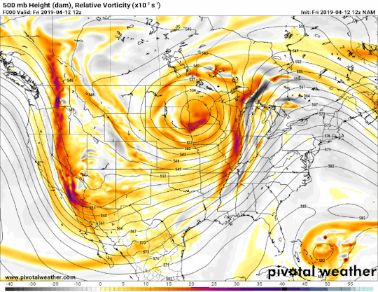
This is a huge weekend at Mississippi State. It’s the biggest weekend of the spring semester: Super Bulldog Weekend. Families and Alumni from all over the country will be coming to Starkville for a variety of events being held in the city and on campus this weekend, including but not limited to: The Art Festival in the Cotton District Saturday morning, the Maroon and White Spring Football game Saturday afternoon, and the Baseball series between the Bulldogs and the Crimson Tide of Alabama. There is just one problem. It is quite possible that the largest severe weather event so far in 2019 could occur Saturday evening. I will discuss the setup and ingredients and give my take on what I think will happen and when the best timing for this event is.
A pretty large trough is propagating across the United States, and thus far has brought some storms and rain to places like Texas and the lower plains. However, it will be pushing into a much more favorable environment as a low pressure develops over Southwest Texas Friday afternoon, and will begin to track northwest into Arkansas on Saturday as the trough begins to lift. The bad news is, as this trough lifts, it will be taking on a negative tilt, which is more favorable for severe weather due to the majority of cyclonic vorticity being on the eastern side of the trough. Additionally, at the 850 mb level, there is some warm air advection, although there definitely could be more. With the positive vorticity advection and the warm air advection, there will be plenty of rising air to enhance the low as it moves into Arkansas and later Tennessee. And higher up, at around 300 mb, there is a jet streak forecasted to move through above the area, which could help to break clouds up ahead of the event to allow instability to grow, and then the back portion of this streak could help storms to fire up.
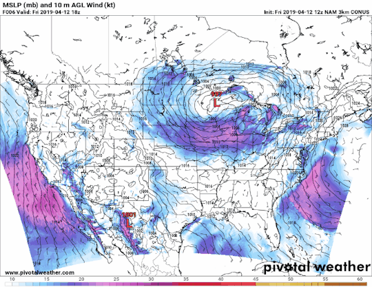
Now for some more details. For starters, the temperatures across the southeast, mainly Mississippi, Arkansas, and Louisiana are going to be in the lower to mid 70s. On top of that, the dewpoints are expected to be in the upper 60s, with some potentially eclipsing 70. In other words, it is going to feel like a sauna outside. This is good for the development of severe weather, however. High dewpoints with warm temperatures means there will be plenty of warm, moist air to fuel the development of strong storms. And with the low tracking through Arkansas into Tennessee, the dynamics will be almost perfect for strong storm development. This includes things such as wind direction and speed, which have been absent from most of the events so far this year.
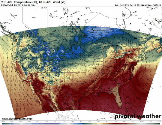
There are a lot of ingredients present along with the setup that could present a major problem but help with the development of severe weather and tornadoes. First and foremost, the surface winds across the susceptible area (MS, AR, LA) are out of the Southeast, and they’re pretty strong too, at least 10 knots across much of the area. And there’s very good turning of the winds above that, with the winds at 850 mb out of the SSW and 700 mb winds out of the southwest, bringing drier air off of the Mexican Plateau and Southeast Texas, which will create a cap preventing storm development early Saturday. The LCL heights are also EXTREMELY low, as in only a couple hundred meters off the ground. This paired with the Southeasterly flow at the surface could be very favorable for tornadic development. On top of that, there is plenty of CAPE, over 1000 J/kg across much of Mississippi and up to 2000 J/kg in parts of Louisiana. So, there’s plenty of energy and favorable conditions for severe weather Saturday evening.

There are a few limiting factors though. The biggest one is the 6km bulk shear. These shear vectors are almost parallel to how the cold front will be moving, meaning that these storms will fire up as independent cells, but then very likely merge into a messy line, which will severely limit the potential for devastating, long track tornadoes. That being said, the southernmost cells are always important to watch, as inflow is not impeded there. Another thing with linear storms is they often have strong straight-line winds, which are what I think the biggest risk with this event is. That is because of all the rain region has seen recently. It won’t take overly strong gusts to uproot trees. The lapse rates are not bad, but they could be better. The stronger the low is, the better the lapse rates will be. As of now they are forecasted to be between 6 and 7 degrees Celsius per km, however if the is stronger than forecasted those will go up, which will in turn cause stronger updrafts. Another potential limiting factor is the fact that the models are forecasting bits of energy ahead of the main system. These could be showers that could take some inflow from the environment, reducing the tornado threat. On the flip side, these could also create moisture boundaries that storms could lock onto, which could make things worse.
So, I do believe this is a very dangerous event. There’s a lot of uncertainty with what will happen, but in terms of timing I think it occurs after 6 pm on Saturday, which would allow both the Spring Game and the 2nd Baseball Game against Alabama to take place in full. But when it comes to what should be expected with the storms themselves, the first thing I will look for tomorrow is if the sun is out, and where the pockets of sunshine are. As I mentioned before, there is forecasted to be a jet streak moving over the area higher up, and the right front quadrant of it could cause enough sinking to break clouds up to build instability. Also, if the shear vectors become less parallel than forecasted and the storms become more discrete supercells instead of a QLCS pattern, Louisiana, Southern Arkansas, and Mississippi could be dealing with a 50+ tornado day. At the same time, the bits of energy ahead could also reduce the threat. We’ll have to see what happens tomorrow.
0 notes
Video
youtube
A STORM OF BEAUTY - Spectacular Phenomenon
Lapso de tempo de trovoada e fenômeno espetacular com fatos e informações de onde testemunhar essas vistas fascinantes. Raios para cima, mammatus, sprites, rajadas de vento e, claro, tornados.
INFORMAÇÃO QLCS:
Um sistema convectivo quase-linear (QLCS), também conhecido como uma linha de tempestade, pode abrigar ventos fortes em linha reta, fortes precipitações, granizo, MUITOS raios e possivelmente tornados ... Para mim, as linhas de tempestade geralmente oferecem cenários espetaculares de tempestades e outros fenômenos estranhos . Este vídeo destaca uma variedade de clima fascinante, além de locais relativos às tempestades de onde você provavelmente testemunhará essas belas paisagens.
NUVENS DE PRATELEIRA:
As nuvens das prateleiras geralmente se formam sobre a borda principal do fluxo de tempestade linear. Ser ultrapassado por uma nuvem de prateleira pode parecer engolido por uma baleia colossal. Dentro da "boca da baleia", nuvens de turbulência sinistra aparecem no céu.
QLCS TORNADOES
As linhas de instabilidade às vezes se estendem por centenas de quilômetros. Esse modo de tempestade geralmente não é prolífico na produção de tornados, uma vez que ventos fortes e frios saem da corrente de ar e sobem à frente da tempestade como uma frente de rajada. Ao longo da frente da rajada de vento, é um bom lugar para procurar redemoinhos de poeira chamados gustados. Tornados transitórios podem se desenvolver repentinamente em convergência ciclônica aprimorada em qualquer lugar em que o QLCS seja capaz de receber influxo próximo à superfície. Às vezes, em torções de linha, as supercélulas incorporadas podem se desenvolver e produzir tornados mais fortes envolvidos pela chuva. Outro lugar para procurar tornados é o desenvolvimento de novos celulares no final da linha, onde o fluxo quente e úmido não é impedido pelo fluxo de tempestades.
QLCS LIGHTNING
Os relâmpagos frequentes podem oferecer oportunidades para belas fotografias e vídeos. O posicionamento atrás da tempestade geralmente oferece uma visão clara das nuvens mammatus, especialmente ao redor do pôr do sol.
Na escuridão crescente, mais e mais atividades relâmpago são reveladas. Na região estratiforme à direita de um QLCS é um excelente local para captar as descargas de raios mais erráticas. O visual mais precioso desses flashes para mim é um raio terra-nuvem ou um movimento ascendente.
QLCS SPRITES and JETS
A dezenas de quilômetros de distância, procure atentamente por rajadas de luz vermelha e fraca acima do QLCS. Essas estranhas descargas elétricas são chamadas de Sprites. As câmeras sensíveis à luz realmente fazem os sprites aparecerem no cenário de estrelas em uma noite escura. Para ver mais sprites, confira o canal do Paul Smith no youtube ...
https: //www.youtube.com/channel/UC9iK ...
0 notes
Text
@notbatmanyet: RT @ReedTimmerAccu: MONSTER DERECHO near Bison, SD earlier with more footage of the mega shelf from the ground. Note the kink in the line with dust beneath to the north. Possible QLCS tornado right there. #CategorySix @RadarOmega_WX #sdwx https://t.co/42WCbP7OT7
from http://twitter.com/notbatmanyet
via IFTTT
0 notes
Text
SPC AC 051728
Day 2 Convective Outlook
NWS Storm Prediction Center Norman OK
1128 AM CST Wed Feb 05 2020
Valid 061200Z - 071200Z
...THERE IS AN ENHANCED RISK OF SEVERE THUNDERSTORMS ACROSS PARTS OF
THE FL PANHANDLE...GA...SC...AND CENTRAL NC...
...SUMMARY...
Scattered severe thunderstorms, capable primarily of damaging gusts
and perhaps a few tornadoes, are expected Thursday from the
northeast Gulf Coast to the Carolinas.
...Southeast to the Mid-Atlantic...
A large-scale upper trough over the Plains and Upper Midwest is
forecast to amplify Thursday as it moves eastward over the MS/TN/OH
Valleys. As this occurs, both a low and mid-level jet should
strengthen across parts of the Southeast into the Mid-Atlantic. At
the surface, a low initially over parts of the OH Valley should
slowly develop northeastward across the Appalachians. A secondary
surface low is forecast to form over the western/central Carolinas
by late Thursday afternoon, and eventually merge with the primary
low over the coastal Mid-Atlantic and Northeast late Thursday night.
A cold front extending southwestward from these surface lows will
sweep eastward across parts of the Southeast into the Carolinas and
Mid-Atlantic.
Storms will very likely be ongoing at the start of the period
Thursday morning along or just ahead of the cold front across parts
of southern/central AL into the FL Panhandle and western GA.
Although instability will remain weak, a strongly sheared wind
profile across this region should support continued storm
organization. Damaging winds would appear to be the primary threat
given the mainly linear storm mode, but a couple embedded tornadoes
cannot be ruled out either given effective SRH generally in excess
of 200 m2/s2.
As the upper trough mentioned previously advances eastward,
southwesterly flow within roughly the 850-700 mb layer is expected
to quickly increase to 50-70+ kt across the warm sector extending
from northern FL northeastward to the Carolinas and southeastern VA.
Low-level moisture should also gradually increase across this
region, with surface dewpoints in the low to mid 60s becoming common
by early Thursday afternoon. Resultant MLCAPE of 250-750 J/kg should
develop even with only modest diurnal heating. Given the very strong
flow present in low to mid-levels and the linear forcing of the
front, at least scattered damaging winds should be the main severe
risk along a line of thunderstorms from parts of northern FL into
much of central/eastern GA, SC, and central NC. A couple QLCS
tornadoes cannot be ruled out either.
An isolated damaging wind threat may persist Thursday evening into
the overnight across much of the FL Peninsula, although large-scale
ascent will more muted compared to locations farther north. Strong
to locally severe wind gusts may also continue with the squall line
Thursday night across central/eastern NC and far southeastern VA.
..Gleason.. 02/05/2020
SPC Day 2 Convective Outlook .
51
0 notes
Text
A snip from the Storm Prediction Center’s morning discussion. Sounds like some crazy storms will be prowling later on today and this evening. And the QLCS-type tornadoes are found at the tip of squall lines. So radar is your friend regarding that.
0 notes
Text
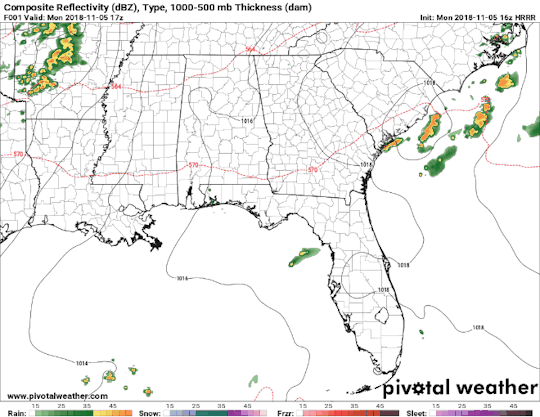
Severe Weather Potential: November 5th, 2018
Severe weather is expected to develop across the mid-south this evening into the overnight hours. The Storm Prediction Center has issued an Enhanced Risk (3/5) for northern portions of Mississippi, southwestern and central portions of Tennessee and extreme southeastern portions of Arkansas. Our primary threats continue to be tornadoes and damaging straight-line winds. Portions of northern Mississippi and southwestern Tennessee have the greatest potential of seeing tornadoes this evening on into the overnight hours.
Monday morning started off chilly and foggy. As we continue to progress throughout the afternoon hours, our southerly winds will increase. This will allow for the fog to mix out of our area, and it will also help bring in moisture in our area. These southeasterly winds will also help create wind shear(pictured below), allowing for a few of these storms to rotate. The main risk for tornadoes will be associated with any cells that develop ahead of the main line associated with this system. These cells will have the greatest potential to develop into strong (EF-2 to EF-5) tornadoes. In the picture above, this would be the hatched region.
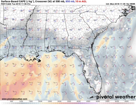
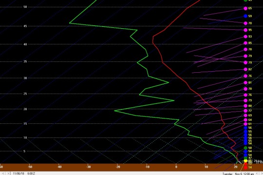
In addition to the threat of tornadoes, we also have the potential to see damaging straight-line winds. The forecast sounding below shows a pocket of dry air aloft with winds out of the WSW between 70 KT and 80 KT. When precipitation falls through this dry air, it will allow these wind speeds to make it to the surface. Once this storm system turns into a QLCS, these winds will become more common than tornadoes.However, a few embedded spin up’s are possible within the QLCS.
This event has a dangerous element with it. Most of the severe storms are going to occur during the evening and overnight hours, after the sun sets. Storms will begin to push into the Mississippi delta around 6 PM Monday evening. As these storms progress across Mississippi, they will become more linear. The line looks to move into the GTR around Midnight. Most of the severe weather will push out of our region by 4 AM. Just to reiterate; tornadoes and damaging winds will be the main threats, in addition to frequent lightning and heavy rainfall. Hail is not a major concern for our area. Timing of this event will be between 6 PM Monday evening through 4 AM Tuesday Morning
You will not be able to see these storms due to their timing. In addition to timing, the visibility across this area is already hindered due to the tall pine trees. The main issue with these storms moving through at night is that most people will be asleep, and not aware of what is headed their way. It is essential to have more than one way to receive severe weather alerts sent to your mobile devices. At WCBI, our WCBI News app will send you push alerts that notify you if a severe weather watch or warning is issued for your location. Another excellent option to receiving warnings is through a NOAA weather radio! These radios will alert you in the middle of the night if a warning is issued for your exact location.
In addition to this, if you are unable to pick up coverage on your television, you can always listen along to WCBI on the radio stations posted below. We simulcast our severe weather coverage to these radio stations so that you can continue to hear us in your vehicle, or even when your power goes out. Stay safe out there tonight!
Have a plan ready in case a severe weather warning is issued for your location.
0 notes
Text
La vita cambia.
Non so perché sto scrivendo tutto ciò... forse ho bisogno di buttare giù tutti i miei pensieri. Sono un uomo del nord, nato e cresciuto in un piccolo paese... carino, ci si vive bene, ma non offre nulla, ma non importa. Comunque tornado a me ho 34 anni e sono sposato da 1 anno e 7 mesi, anzi lo ero. Eh già lo ero. Mio marito ha capito che siamo incompatibili di carattere, e non sapeva più se mi amava. Io non ce l’ho fatta, me ne sono andato. Non puoi non sapere se ami o no. Almeno credo sia così.
Sono cresciuto con la consapevolezza che lì fuori c’era qlc che mi aspettava veramente.. maschio o femmina non importava, volevo amare.. volevo amare alla follia, volevo dei sentimenti veri e profondi... volevo amare ed essere amato. (Sono una teenager americana che crede alle favole!!!)
E sembrava tutto realizzato! Bella casa cani macchina e moto... mancava solo la stabilità economica. Sognavamo un figlio. Si sognavamo un foglio ma lui non sapeva se mi amava... 🤦🏻♂️e invece non è stato così. Tutto è cambiato in una settimana.
Il mondo trema sotto i tuoi piedi, e le certezze cadono per lasciare spazio a dubbi rabbia e delusione.
E tu non puoi fare tanto.
Devi tenere la testa alta... e camminare ancora e ancora, orgoglioso di quello che sei e sei stato. Sapendo che ci sarà un nuovo te, ancora una volta. Ma sarai sempre più forte. Finché nessuno ti farà più soffrire.
0 notes
Text
What is Ghosting?

Why People Ghost and What To Do If It Happens To You
Tired of Getting Ghosted?
Dating is not easy. This is something I hear often in my work with quarterlife clients. They describe the ups and downs of dating, their nervousness on first dates, and doubts about whether the other person wants to see them again. In dating, you are consumed with questions like: Will we play games or can we cut through the bullshit and just be real with each other? Is there a future for us? Did I get too drunk? How soon can we have sex?
I’ve been hearing a lot about ghosting from clients lately. What is ghosting? It’s when the person you are dating abruptly disappears and stops texting (because, as I’ve been told, no one makes actual phone calls anymore). Ghosting often occurs after multiple dates, sometimes even after months of dating. A recent book of poetry written by Samantha Jayne entitled Quarterlife Poetryperfectly describes ghosting.
___________________________________________________
“Our first date was magic
the next was okay
I texted for thirds
but he ghosted away…”
–Quarterlife Poetry By Samantha Jayne
_____________________________________________________
Being ghosted is confusing and frustrating. It can result in a tornado of questions swirling in your head: “Where did she go?” “Did she get my text?” “What did I do wrong?” “How could I have misread this? “Did we have sex too soon?” You may find yourself speculating as to the reason for the sudden silence: “He may have lost his phone.” “Maybe she’s married and her husband found out.” “I hope he wasn’t in a terrible accident!”
So, Why Do People Ghost?
The answer is usually pretty simple. Ghosting is easier than having to tell you that they don’t want to continue to date you (or, perhaps, that they are ambivalent about dating you). Many people fear confrontation and think that being direct will hurt your feelings; so they avoid dealing with it at all. And they just slip away… like a ghost.
How Do I Handle Being Ghosted?
Acknowledge It.
If you’ve reached out and haven’t heard back from the other person, you might consider contacting them one more time to confirm that they received your text or message. If you still don’t hear back within several days, it is likely that you’ve been ghosted. You should MOVE ON and make your own plans –for this Saturday night, and your life. Don’t put your plans on hold while you wait to hear back from the other person.
Reflect on What Happened. Don’t Obsess.
Once you realize you’ve been ghosted, you will probably feel confused and will want to make sense of it.
Self-reflection is a good thing, but don’t get stuck in negative self-talk and obsessive thought patterns. It is important for you to understand what happened and why; but with the other person out of the picture you only have yourself to probe. That’s ok because you are not looking to assign blame, but rather to understand your own thoughts and behaviors. Ask yourself whether you could have seen this coming. Did you overlook red flags early on? Have you fallen into a pattern of pushing people away or dating people who don’t want a commitment? Were there specific conflicts that were brewing but were never addressed?
If you find that you’re obsessing about it, distract yourself with a fun activity or set time limits. For example, set a timer for 15 minutes, let yourself feel and think about the relationship as much as you can. But when the timer sounds, move on.
Remember: Although a post-hoc examination of the relationship might help you understand why you were ghosted, most of the time, the reason(s) won’t become clear. It’s quite possible that the ghosting had nothing to do with you or your behavior. Often people ghost because of something happening in their own lives.
Identify red flags.
Review the relationship to determine whether you overlooked red flags early on. Did the other person seem ambivalent about dating you? Were you the only one initiating communication and dates? Sometimes, people ignore signs of incompatibility because they want the relationship to continue.
Identifying warning signs from this relationship can help you acknowledge red flags, and deal with them, earlier on in your future relationships.
Get Closure.
Depending on how long you dated and the attachment you developed, you may feel a range of emotions like disappointment, surprise, and even betrayal. In order to achieve closure, you must acknowledge your feelings and give yourself some time to heal.
There are two ways to get closure:
intra-personally: within yourself (i.e., self-reflection, venting to friends, journaling), and
interpersonally: with the person who ghosted you (i.e., writing a note or text wishing the person well and saying goodbye).
Take Care of Yourself. And Move On.
Like I mentioned at the beginning of this post, move forward with your own plans. Don’t put your life on hold while you wait to hear from the other person.
About Quarterlife Center (QLC):
Our QLC Counselors specialize in working with individuals and couples in their 20s and 30s in a supportive, caring, confidential setting. We will work with you to help you identify your passions, achieve your goals and thrive in your life.
Quarterlife Center offers the following services to clients:
Individual Counseling
Couples Counseling
Premarital Counseling
Career Coaching
Perinatal/Postpartum Counseling
If you’d like more information or you’re interested in scheduling an appointment,please contact.
#Quarterlife Counseling#Quarterlife Crisis#Quarterlife Center#QLC#Individual Counseling#Couples Counseling#Premarital Counseling#Postpartum Counseling#Perinatal Counseling#Career Coaching#Mental Health Counseling#Mental Health Support
0 notes
Text
Severe Wx possible for the AR,LA,MISS Region.
February 22nd, 2018
The spring severe weather season is closing in for 2018 and especially across the south which sees its peak months for tornadoes in March and April. With March right around the corner and in a very high amplitude trough/ridge pattern things can get messy, from snow and 20s to tornadoes and 80s. There is a threats for sever weather in parts of western MS, Eastern AR, LA and west TN this saturday that requires close monitoring for at least some tornado potential.
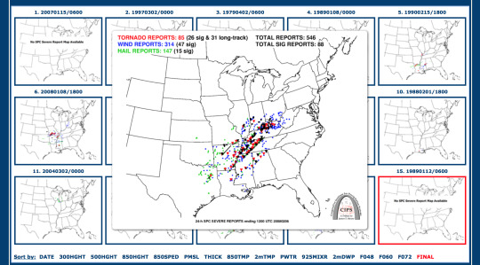
For most of the week and up to this point the top analog for Saturday’s severe weather potential is the Super Tuesday Outbreak of 2008 which spawned 85 tornadoes over 10 states. Latest guidance shows that the setup for Saturday will be no where as impactful as the Super Tuesday Outbreak but this analog cannot be ignored if mesoscale conditions prior to the onset of the event favor discrete cells everything can change. 9 out of 15 analogs for Saturdays setup had some tornado reports associated with them, this of course is based off todays 12Z NAM data.
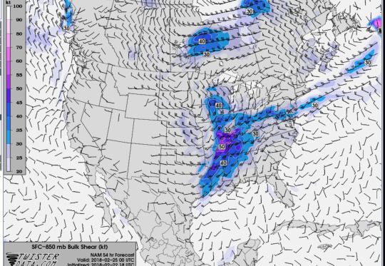
A strengthening low level jet/ 850mb shear of 40 to 50 kts in NW AR and the AR Delta is where I think the largest threat for tornadoes exists as Bulk Shear in the mid and upper levels is also supportive of initial tornado-genisis upon the onset of initial convection as is pushes east over this area. The low level and mid level jet is strong and a little parallel to the surface boundary and winds aren't backed like you see in a classic supercell set up. So, there are some concerns about the duration and life span of any tornadoes that form as the convection will quickly merge into a MCS or QLCS feature before crossing into MS late Saturday evening and through the over night hours Sunday morning. Wind for now should be the largest threat along the leading edge of the squall.
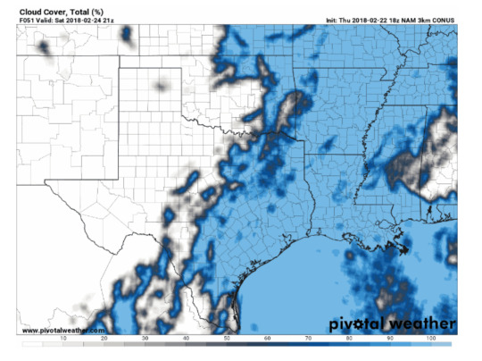
Another thing to consider is cloud cover and prefrontal rain that could limit SBCAPE and boundary layer instability from reaching critical point for initial pre frontal convection Saturday afternoon that could pose any tornado threat. Nonetheless, if clouds are too break up in the warm sector upon arrival of crashing cold front then significant destabilization of the PBL and ML could occur and in conjunction with these factors could play a crucial role in discrete storms to initiate. For now I think there is enough low level moisture and upper level forcing that will cause stratiform rain/ storms to occur in the AR, LA, Miss region that will limit CAPE values to under 1000 J/KG (Not enough for sustained long lived super cells).
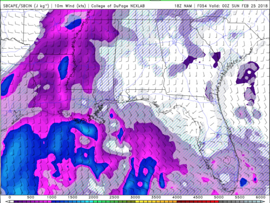
A speaking of CAPE, as of right now nice return flow from the GOM combined with deep layer moisture and temperatures in the low to mid 70s should allow for SBCAPE to be at least 500 J/Kg - 1000 J/Kg but with the low level cloud cover which I fully expect should keep instability marginal or sub 1000 J/Kg preventing long term and scattered discrete cells ahead of the cold front. The only way to determine these parameters are sfc obs and sounding data on Saturday morning alone with any mescal boundaries left over from previous convection. Also if winds aren't backed enough which is quit possible given the upper level dynamics with regards to the location of the surface could be too far north.
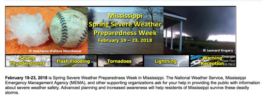
As a reminder this week in Severe Weather Awareness week for the Jackson NWS office. It is crucial that you check with your local EMA and local officials to receive any severe weather tips and preparedness plans in case of a severe weather emergency. Sources to help prepare can be achieved by owning a NOAA Wx Radio, Downloading severe wx apps and checking with any bulletins from local EMA staff in your area. God Speed and lets bag some wedges this year.
0 notes
Last Seen Blogs

dontmesswithalady
Lady

skunkist
Skunkrock!

nancysauria
NancySauria
its-sadnesswords
SAD WORDS
dezisions
DezisionsWords