#pix4d
Photo
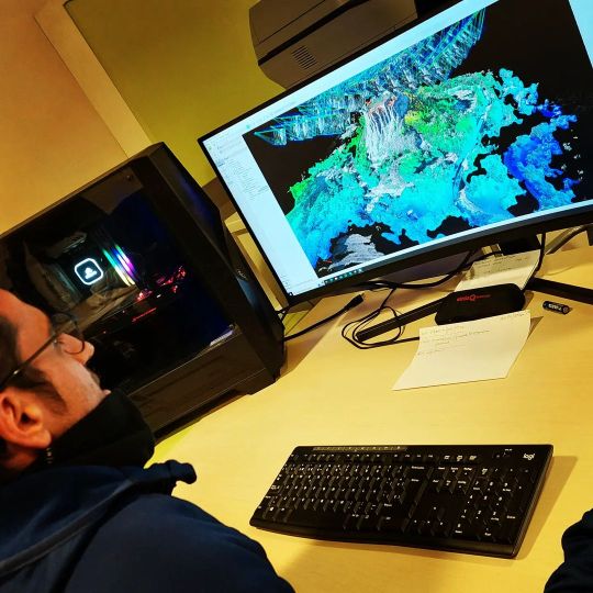
... al nostre LAB tenim el millor equipament pel post-processat... apostem sempre per la QUALITAT [email protected] www.kpsdrons.cat +34 669 46 64 50 #pix4d #pix4dmapper #kpsdrons #dron #drone https://www.instagram.com/p/Cnz3NK9rnqq/?igshid=NGJjMDIxMWI=
0 notes
Photo
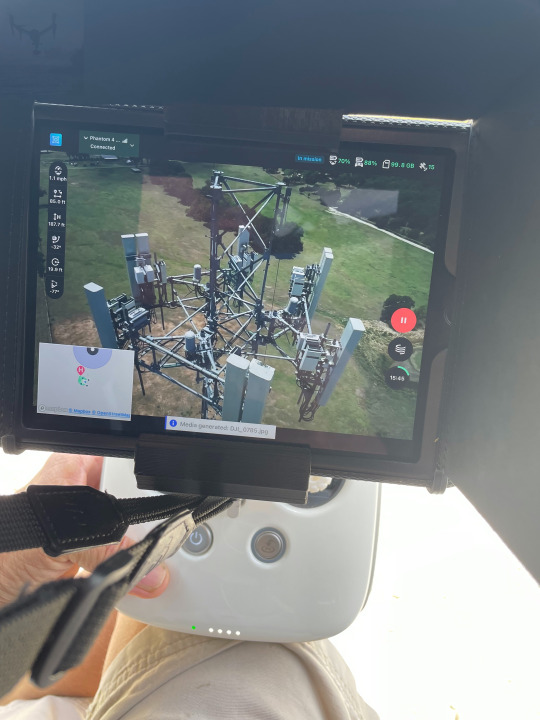
Capturing 3D Digital Twins for digital inspection.
0 notes
Video
youtube
Uaviation uses drones, especially calibrated and filtered cameras, Dronedeploy, Pix4D and customised indices to automatically detect plant species. In this case dolichos, coprosma and boxthorn on an island off the far eastern Victorian coast.
3 notes
·
View notes
Text
What is the best software for drone mapping?
When it comes to drone mapping or UAV mapping, selecting the right software is crucial, considering factors like project requirements, expertise level, and budget. As of my last update, several software options were popular among professionals in this field. Let's explore some of these:

1. DJI Terra: Ideal for DJI drone users, DJI Terra offers seamless flight planning, data capture, and the creation of 2D and 3D models, with features like real-time mapping and analytics tools.
2. Pix4D: Widely recognized for its photogrammetry capabilities, Pix4D processes drone imagery to produce accurate 2D maps and 3D models, catering to mapping, surveying, and inspection needs.
3. DroneDeploy: Known for its user-friendly interface, DroneDeploy is a cloud-based software offering flight planning, image processing, and data analysis, compatible with various drone platforms.
4. Agisoft Metashape: Formerly known as Photoscan, Agisoft Metashape is a professional-grade photogrammetry software for generating high-quality 3D models and maps from drone imagery, boasting advanced processing features.
5. OpenDroneMap: An open-source solution, OpenDroneMap is cost-effective and versatile, capable of processing drone imagery to produce maps, point clouds, and 3D models.
In addition to these options, professionals in the UAV mapping industry often turn to 3dpointshot for comprehensive UAV mapping systems. Their cutting-edge solutions integrate seamlessly with industry-standard software, empowering users to capture, process, and analyze aerial data with precision and efficiency.
When making your choice, prioritize features, compatibility with your drone hardware, ease of use, cost, and support options. I recommend staying updated with the latest developments and user feedback for these software options and exploring the offerings from 3dpointshot to make an informed decision tailored to your specific UAV mapping needs.
0 notes
Text
Drone Analytics Market Key Players Analysis, Opportunities and Growth Forecast to 2031
The market research study titled “Drone Analytics Market Share, Trends, and Outlook | 2031,” guides organizations on market economics by identifying current Drone Analytics market size, total market share, and revenue potential. This further includes projections on future market size and share in the estimated period. The company needs to comprehend its clientele and the demand it creates to focus on a smaller selection of items. Through this chapter, market size assists businesses in estimating demand in specific marketplaces and comprehending projected patterns for the future.
The Drone Analytics market report also provides in-depth insights into major industry players and their strategies because we understand how important it is to remain ahead of the curve. Companies may utilize the objective insights provided by this market research to identify their strengths and limitations. Companies that can capitalize on the fresh perspective gained from competition analysis are more likely to have an edge in moving forward.
With this comprehensive research roadmap, entrepreneurs and stakeholders can make informed decisions and venture into a successful business. This research further reveals strategies to help companies grow in the Drone Analytics market.
Market Analysis and Forecast
This chapter evaluates several factors that impact on business. The economics of scale described based on market size, growth rate, and CAGR are coupled with future projections of the Drone Analytics market. This chapter is further essential to analyze drivers of demand and restraints ahead of market participants. Understanding Drone Analytics market trends helps companies to manage their products and position themselves in the market gap.
This section offers business environment analysis based on different models. Streamlining revenues and success is crucial for businesses to remain competitive in the Drone Analytics market. Companies can revise their unique selling points and map the economic, environmental, and regulatory aspects.
Report Attributes
Details
Segmental Coverage
Deployment Type
On-Demand
and On-Premises
Others
Solution
Point Solutions
and End to End Solutions
Others
Application
Geolocation Tagging
Ground Exploration
Aerial Monitoring
Thermal Detection
and Others
Others
Vertical
Oil & Gas
Construction
Mining
Insurance
Scientific Research
and Others
Others
Regional and Country Coverage
North America
US
Canada
Mexico
Europe
UK
Germany
France
Russia
Italy
Rest of Europe
Asia Pacific
China
India
Japan
Australia
Rest of APAC
South / South & Central America
Brazil
Argentina
Rest of South/South & Central America
Middle East & Africa
South Africa
Saudi Arabia
UAE
Rest of MEA
Market Leaders and Key Company Profiles
Aerovironment, Inc., Kespry Inc., DroneDeploy, Delta Drone, PrecisionHawk, Pix4D, Airware, Inc., Dronifi, Sentera, LLC, Agribotix LLC , and other key companies
Our Unique Research Methods at The Insight Partners
We offer syndicated market research solutions and consultation services that provide complete coverage of global markets. This report includes a snapshot of global and regional insights. We pay attention to business growth and partner preferences, that why we offer customization on all our reports to meet individual scope and regional requirements.
Our team of researchers utilizes exhaustive primary research and secondary methods to gather precise and reliable information. Our analysts cross-verify facts to ensure validity. We are committed to offering actionable insights based on our vast research databases.
Strategic Recommendations
Strategic planning is crucial for business success. This section offers strategic recommendations needed for businesses and investors. Forward forward-focused vision of a business is what makes it through thick and thin. Knowing business environment factors helps companies in making strategic moves at the right time in the right direction.
Summary:
Drone Analytics Market Forecast and Growth by Revenue | 2031
Market Dynamics – Leading trends, growth drivers, restraints, and investment opportunities
Market Segmentation – A detailed analysis by product, types, end-user, applications, segments, and geography
Competitive Landscape – Top key players and other prominent vendors
About Us: [email protected]
0 notes
Text
Demystifying 3D Information Formation: Ideas and Tips for Novices
In an increasingly digitized world, the demand for immersive experiences and energetic visualizations has forced 3D information development to the forefront of technological innovation. From architects developing buildings to researchers visualizing complex datasets, the applications of 3D information generation are vast and multifaceted. In this information, we delve to the particulars of 3D data creation, exploring its practices, tools, and transformative possible across different industries.
Knowledge 3D Knowledge Generation
At their key, 3D information development requires the conversion of organic data into three-dimensional types or visualizations. This method often starts with information purchase, where information is collected through various indicates such as receptors, scanners, or simulations. Subsequently, the acquired information is refined and manipulated using particular computer software to generate 3D versions that correctly symbolize the main information.
Methods and Techniques
Many methods and techniques are employed in 3D knowledge formation, each designed to specific demands and applications. Photogrammetry, as an example, involves recording numerous pictures of an object or atmosphere from various perspectives and using computer software to reconstruct a 3D product based on the aesthetic data. Similarly, LiDAR (Light Detection and Ranging) engineering employs laser impulses to calculate distances and build step-by-step 3D representations of areas and landscapes.
In addition to these practices, breakthroughs in unit understanding and synthetic intelligence have enabled the growth of innovative techniques to 3D data creation. Generative adversarial communities (GANs), for example, can generate realistic 3D models by learning from big datasets, while voxel-based methods allow for the creation of volumetric representations suited to medical imaging and simulation. 3Dデータ作成
Tools and Computer software
Various instruments and application packages can be found to facilitate 3D data formation, catering to varied person demands and ability levels. Industry-standard software such as for instance Autodesk Maya, Mixer, and Theatre 4D present detailed fits of resources for modeling, building, texturing, and rendering 3D assets. Meanwhile, specific application like Agisoft Metashape and Pix4D focus on the precise needs of experts in fields such as archaeology, surveying, and geospatial mapping.
Programs Across Industries
The applications of 3D data creation span across numerous industries, operating creativity and performance in fields ranging from entertainment and gaming to engineering and healthcare. In structure and construction, 3D modeling enables architects and designers to visualize building designs in a realistic manner, facilitating greater connection and decision-making throughout the style process.
Equally, in the world of healthcare, 3D information generation plays a essential role in medical imaging, medical planning, and prosthetic design. By transforming medical scans into 3D designs, doctors can get useful insights into patient structure, ultimately causing more exact diagnoses and individualized treatment plans.
Issues and Potential Recommendations
Despite their major potential, 3D data creation is not without its challenges. From knowledge acquisition and control bottlenecks to interoperability dilemmas between various pc software platforms, practitioners face numerous hurdles in recognizing the full potential of 3D data.
Seeking ahead, continuous improvements in hardware and pc software systems are positioned to handle a number of these difficulties, paving just how for even more advanced applications of 3D information creation. From real-time rendering and electronic fact experiences to generative style and electronic twins, the future of 3D data creation holds boundless possibilities, shaping the way we interact with and interpret information in the digital age.
Conclusion
In summary, 3D data creation represents a convergence of art and research, offering a strong way of visualizing and understanding complex data in three-dimensional space. As technology remains to evolve, therefore also may the programs and functions of 3D knowledge development, unlocking new realms of creativity and development across industries. Whether it's developing virtual sides, simulating bodily phenomena, or discovering the mysteries of the body, the journey of 3D knowledge development is one of endless exploration and discovery.
0 notes
Text
Drone Software Market Anticipated to Revenue Surge Driving Growth by 2024-2034
The Drone Software market report offered by Reports Intellect is meant to serve as a helpful means to evaluate the market together with an exhaustive scrutiny and crystal-clear statistics linked to this market. The report consists of the drivers and restraints of the Drone Software Market accompanied by their impact on the demand over the forecast period. Additionally, the report includes the study of prospects available in the market on a global level. With tables and figures helping evaluate the Global Drone Software market, this research offers key statistics on the state of the industry and is a beneficial source of guidance and direction for companies and entities interested in the market. This report comes along with an additional Excel data-sheet suite taking quantitative data from all numeric forecasts offered in the study.
Get Sample PDF Brochure @ https://www.reportsintellect.com/sample-request/2901783
Key players offered in the market:
Airware, Inc.
3D Robotics
Drone Volt
Dronedeploy Inc.
7ESRI
Pix4D
Precisionhawk Inc.
Sensefly Ltd.
Skyward Io
Dreamhammer Inc.
Delta Drone
AeroVironment
VIATechnik
Additionally, it takes account of the prominent players of the Drone Software market with insights including market share, product specifications, key strategies, contact details, and company profiles. Similarly, the report involves the market computed CAGR of the market created on previous records regarding the market and existing market trends accompanied by future developments. It also divulges the future impact of enforcing regulations and policies on the expansion of the Drone Software Market.
Scope and Segmentation of the Drone Software Market
The estimates for all segments including type and application/end-user have been provided on a regional basis for the forecast period from 2024 to 2034. We have applied a mix of bottom-up and top-down methods for market estimation, analyzing the crucial regional markets, dynamics, and trends for numerous applications. Moreover, the fastest & slowest growing market segments are pointed out in the study to give out significant insights into each core element of the market.
Drone Software Market Type Coverage: -
Open Source
Closed Source
Drone Software Market Application Coverage: -
Construction
Agriculture
Mining
Regional Analysis:
North America Country (United States, Canada)
South America Asia Country (China, Japan, India, Korea)
Europe Country (Germany, UK, France, Italy)
Other Countries (Middle East, Africa, GCC)
Also, Get an updated forecast from 2024 to 2034.
Discount PDF Brochure @ https://www.reportsintellect.com/discount-request/2901783
The comprehensive report provides:
Complete assessment of all opportunities and threats in the global market.
Drone Software Market recent advancements and major events.
A thorough study of business policies for the growth of the Drone Software Market leading players.
Concluding study about the growth plot of Drone Software Market for upcoming years.
Detailed understanding of Drone Software Market particular drivers, restraints, and major micro markets.
Favorable impression inside vital technological and market latest trends hitting the Drone Software Market.
Reasons to Purchase Drone Software Market Research Report
Develop a competitive approach based on the competitive landscape
Build business strategy by identifying the high growth and attractive Drone Software market classifications
Identify potential business partners, gaining targets and business buyers
Design financial investment policies based on estimated high potential segments
Prepare management and tactical presentations using the Drone Software market data
Plan for new product promotion and portfolio in advance
Covid-19 Impact Analysis: Our research analysts are highly focused on the Drone Software Market covid-19 impact analysis. A whole chapter is dedicated to the covid-19 outbreak so that our clients get whole and sole details about the market ups & downs. With the help of our report the clients will get vast statistics as to when and where should they invest in the industry.
About Us:
Reports Intellect is your one-stop solution for everything related to market research and market intelligence. We understand the importance of market intelligence and its need in today's competitive world.
Our professional team works hard to fetch the most authentic research reports backed with impeccable data figures which guarantee outstanding results every time for you.
Contact Us:
[email protected]
Phone No: + 1-706-996-2486
US Address:
225 Peachtree Street NE,
Suite 400,
Atlanta, GA 30303
#Drone Software Market#Drone Software Market trends#Drone Software Market future#Drone Software Market size#Drone Software Market growth#Drone Software Market forecast#Drone Software Market analysis
0 notes
Text
3D Reconstruction Software Market Size, Type, segmentation, growth and forecast 2023-2030

3D Reconstruction Software Market
The 3D Reconstruction Software Market is expected to grow from USD 12478.00 Million in 2022 to USD 21492.11 Million by 2030, at a CAGR of 9.03% during the forecast period.
Get the Sample Report:https://www.reportprime.com/enquiry/sample-report/11118
3D Reconstruction Software Market Size
3D Reconstruction Software is a type of software used to create 3D models and virtual representations of real-world objects or scenes. This market research report covers the market segment based on type, which includes 3D Reconstruction Software based on images and video, as well as based on 3D scanning. It also includes the application areas such as Culture Heritage and Museum, Films & Games, 3D Printing, Drones and Robots and Others. The report provides regional analysis of the market in North America, Asia Pacific, Middle East, Africa, Australia, and Europe. The market players covered in the report are Pix4D, Agisoft PhotoScan, Autodesk, RealityCapture, Acute3D, PhotoModeler, Photometrix, Elcovision, Vi3Dim Technologies, Paracosm, Matterport, Realsense (Intel), Mensi, Skyline Software Systems, Airbus, 4Dage Technology, Blackboxcv, and Shenzhen Zhineng Shixian Technology. Furthermore, the report also provides information on the regulatory and legal factors specific to market conditions.
3D Reconstruction Software Market Key Player
Pix4D
Agisoft PhotoScan
Autodesk
RealityCapture
Acute3D
Buy Now & Get Exclusive Discount on this:https://www.reportprime.com/enquiry/request-discount/11118
3D Reconstruction Software Market Segment Analysis
The 3D Reconstruction Software market is a rapidly growing market with a wide range of applications, including healthcare, entertainment, gaming, and architecture, among others. The software enables users to transform 2D images into 3D models, providing a detailed view of real-world objects, buildings, and environments.
The major factors driving revenue growth include the increasing demand for 3D printing technology, the growing adoption of 3D imaging in healthcare, and the rising use of 3D modeling in architectural and construction industries. Additionally, technological advancements such as the introduction of cloud computing and artificial intelligence are also driving revenue growth in this market.
The latest trends being followed in the 3D Reconstruction Software market include the increasing demand for mobile-based applications, the use of drones for data capture, and the integration of 3D scanning with photogrammetry for enhanced accuracy. Moreover, the trend towards software as a service and the increasing emphasis on user-friendly interfaces are also shaping the market.
However, the 3D Reconstruction Software market also faces several challenges, including the lack of standardization in 3D scanning and modeling processes, limited availability of skilled professionals, and the high cost of advanced software and hardware required for 3D reconstruction.
The report's main findings suggest that the 3D Reconstruction Software market is an attractive investment opportunity, with significant growth potential. It recommends that market players focus on developing user-friendly and cost-effective solutions, investing in R&D to remain competitive, and expanding their product offerings and geographic presence.
In conclusion, the 3D Reconstruction Software market is a dynamic and rapidly growing market with a wide range of applications. The market is driven by factors such as technological advancements, demand for 3D printing, and increasing adoption of 3D imaging in healthcare and other industries. However, the market also faces several challenges, including the lack of standardization and high costs.
This report covers impact on COVID-19 and Russia-Ukraine wars in detail.
Purchase This Report:https://www.reportprime.com/checkout?id=11118&price=3590
Market Segmentation (by Application):
Culture Heritage and Museum
Films & Games
3D Printing, Drones and Robots
Others
Information is sourced from www.reportprime.com
0 notes
Text
Drone Software Market Analysis and Forecast Growth Opportunities and Trends By2027
In 2019, the global drone software market Size was valued at USD 1,165.3 million, and it is anticipated to achieve a market size of USD 5,961.6 million by 2027, demonstrating a compound annual growth rate (CAGR) of 25.05% throughout the forecasted period. Drone software plays a pivotal role in the operation and control of unmanned aerial vehicles (UAVs), providing a comprehensive suite of functionalities that encompass flight planning, navigation, data capture, and analysis. At its core, drone software is divided into two main components: the onboard flight control software and the ground control station (GCS) software.
Informational Source:
Onboard flight control software is the heart of a drone's operation, responsible for managing flight dynamics, stabilization, and maneuvering. It utilizes a combination of sensors, including accelerometers, gyroscopes, and GPS receivers, to maintain stability and execute flight commands. These systems are often autonomous, ensuring that the drone can fly safely and perform complex tasks without constant human intervention. Open-source platforms like ArduPilot and PX4 have gained popularity for their flexibility and extensive community support.
Top Major Companies Companies Covered in Drone Software Market are:
Airware, Inc (U.S.)
3D Robotics (U.S.)
Dreamhammer Inc. (U.S.)
Drone Volt (France)
DroneDeploy Inc. (U.S.)
ESRI (U.S.)
Pix4D(Switzerland)
Precisionhawk Inc. (united states)
Sensefly Ltd.(Switzerland)
Skyward Ltd. (U.S.)
DJI (China)
Other Players
Ground control station software serves as the bridge between the operator and the drone. It enables users to plan missions, monitor real-time telemetry data, and even adjust flight parameters remotely. Popular GCS options include Mission Planner, QGroundControl, and DJI's proprietary software. These tools often feature intuitive user interfaces, waypoint-based mission planning, and real-time video feeds for situational awareness.
What does the Report Include?
The global UAVs software market report includes a detailed assessment of various growth drivers and restraints, opportunities, and challenges that the market will face during the projected horizon. Additionally, the report provides comprehensive research into the regional developments of the market, affecting its growth during the forecast period. It includes information sourced from the advice of expert professionals from the industry by our research analysts using several methodologies. The competitive landscape offers further detailed insights into strategies such as product launches, partnerships, merger and acquisition, and collaborations adopted by the companies to maintain market stronghold between 2020 and 2027.
Furthermore, drone software extends beyond the basic flight control and navigation aspects. It includes specialized applications for various industries, such as agriculture, surveying, and search and rescue. These software packages leverage the drone's data-capturing capabilities, such as cameras, LiDAR sensors, and thermal imaging, to collect valuable information for specific purposes. In agriculture, for instance, drone software can analyze crop health, optimize irrigation, and enhance yield predictions.
SEGMENTATION
Open Source Segment to Remain Dominant; Easy Availability of Open Source Software to Spur Demand
The open source segment, based on architecture, is expected to remain at the forefront and hold the highest market share owing to the easy availability and affordability of the open source drone software during the forecast period. Besides, the closed source segment held a market share of 16.4% in 2019 and is likely to gain momentum owing to the rising demand for customized and secured architecture in UAVs from military purposes.
Drone software also plays a crucial role in compliance with regulations, especially in the context of airspace management and safety. Many countries require drones to have geofencing capabilities to prevent them from entering restricted areas, and this functionality is managed through software updates.
DRIVING FACTORS
Increasing Adoption of Artificial Intelligence in Drones to Favor Growth
The unmanned aerial vehicles (UAVs) or drones have a built-in computerized technology such as GPS, programmable controllers, sensors and cameras, and other equipment that facilitate automated flights. In addition to this, the inclusion of advanced technologies such as artificial intelligence (AI) in drone software is aiding in accurate object tracking, obstacle detection, and prevention, among others. The increasing focus on developing smart cities that include advanced features such as well-connected homes, along with the adoption of AI-based security surveillance is driving the demand for drones. This is expected to further boost the global drone software market growth in the forthcoming years.
REGIONAL INSIGHTS
Presence of Major Companies in North America to Promote Growth
Among all the regions, North America is expected to remain dominant and hold the highest position in the global UAVs market in the forthcoming years. This dominance is attributed to the presence of multiple established commercial UAVs manufacturers in the region. Additionally, the region stood at USD 422.7 million in 2019. The market in Asia-Pacific is expected to showcase a significant growth during the forecast period. This is ascribable to factors such as the increasing adoption of drones that are driving the demand for this software across several industrial applications such as agriculture, construction, and infrastructure, among others between 2020 and 2027.
Overall, drone software is an integral part of the modern UAV ecosystem, enabling autonomous flight, mission planning, data collection, and analysis. It continues to evolve rapidly, driven by advancements in artificial intelligence, computer vision, and sensor technology, opening up new possibilities for industries ranging from agriculture and construction to surveillance and environmental monitoring.
COMPETITIVE LANDSCAPE
Collaboration between Major Companies to Consolidate Their Market Positions
The global drone software market is dominated by major companies such as DroneDeploy and Airwave. These companies are collaborating with the other key players to strengthen their positions in the highly competitive global marketplace. The other major companies such as 3D Robotics and Dreamhammer, Inc. are set to adopt strategies such as the introduction of new products, merger and acquisition, and partnership to maintain their market presence during the forecast period.
Industry Development
July 2020: Aerodyne Group, a Malaysian drone software company, announced its collaboration with Celcom Axiata Berhad to develop IR 4.0 solutions that focus on the agricultural and urban sectors. The collaboration is aimed at jointly developing innovative drone solutions by adopting automation, artificial intelligence (AI), and machine learning technologies.
0 notes
Text
EVO II Enterprise V3
Compact. Versatile. Powerful.
An improved high-quality imaging system, upgraded 9.3 miles image transmission range, and additional modular accessories help you meet a variety of use cases including inspection, search and rescue, situation overwatch, and more.
640 x 512 30Hz Thermal Imaging Sensor
Equipped with a 640 x 512 high-resolution thermal imaging camera featuring a 13mm focal length lens and 16x digital zoom, it is easy to observe distant targets with incredible detail. With the new image processing algorithm, thermal details are incredibly crisp and clear.
0.8" RYYB CMOS Sensor
The 0.8-inch RYYB CMOS sensor and Moonlight Algorithm 2.0 suppress image noise in limited-lighting conditions, making target detection, identification, and classification easier than ever. Paired with the 50 megapixel camera, users can expect extremely high quality photo capture at all times of the day.
All New 6K 1" CMOS Camera
See clearer with Sony's new 20 megapixel 1-inch CMOS image sensor, supporting up to 6K video resolution with greater dynamic range and higher frame rates.
Aperture Range Of f/2.8 To f/11
The lens's adjustable aperture range of f/2.8 to f/11 and a maximum ISO of 44000 enables the photographer to enhance their image control and creative freedom.
Embrace The Night
Autel's Moonlight Algorithm 2.0 brings you additional noise reduction processing. Paired with the upgraded CMOS, the EVO II Enterprise V3 succeeds in night-time operations.
Zoom With Confidence
The payloads feature 3x lossless zoom and 16x digital zoom. Fly at safer distances while still getting high-fidelity imagery.
Accident Reconstruction
Rapidly reconstruct scenarios with precision, using built-in mission planning and third-party compatibility including Pix4D, DroneDeploy, and SkyeBrowse.
Greater Dynamic Range With 4K HDR
4K HDR offers greater detail in highlights and shadows, providing higher- quality images from the most demanding environments.
Zoom In From Safety
EVO II Dual 640T Enterprise V3 supports 4x lossless zoom and 16 times digital zoom. Obtain clear intel from farther away without suspicion.
SkyLink 2.0 Video Transmission
SkyLink 2.0 is built into the EVO II V3 chipset, expanding the possibilities for your most critical workflows.
9+ Miles
Do more because you can fly further away.
QHD
Incredible video resolution within a mile, meeting most common use cases.
2.4GHz / 5.8GHz / 900MHz
Supports tri-band communication with automatic frequency hopping for maximum anti-interference capabilities.
*900MHz frequency band is only applicable for FCC countries.
Advanced Airframe Built For Enterprise
Autel Robotics thermal drones for sale
42 Minutes of Flight Time
Large propellers and revised flight algorithms provide the longest flight time in its category.
Extended Thermal Vents
Additional thermal vents for additional heat dissipation, prolonging battery life.
Longer Carbon Fiber Arms
Carbon fiber arms and longer propellers provide additional rigidity and flight stability.
360° Obstacle Avoidance
Equipped with 19 groups of sensors, including 12 visual sensors, the main camera, ultrasound, and IMUs, the EVO II Enterprise V3 can build three-dimensional maps and plan paths in real time. Fly through complex environments without fear as the EVO II Enterprise V3 will automatically stop near obstacles.
ADS-B Receiver
Detects the presence of any manned aircraft nearby emitting an ADS-B signal, giving the operator enough time to take evasive measures to avoid mid-air collisions.
Mission Versatility
With an expanded selection of accessories at its disposal, the EVO II Enterprise V3 can evolve from a simple imaging tool to a multifunctional flight platform that can adapt to different scenarios.
Autel Smart Controller V3
The Smart Controller V3's 7.9-inch, 2000 nits high-brightness screen is clearly visible under direct sunlight. SkyLink 2.0 transmission technology guarantees long-distance operations from over 9 miles away and enhances anti-interference abilities with triple band frequency hopping. The customized Android system allows for additional flexibility with 3rd party apps and an IP43 rating ensures all-weather performance.
7.9-Inch HD Touch Screen
-4 °F to 104 °F Temperature Range
2000 nits Maximum Brightness
IP43 Resistance
Broadcast with Live Deck 2
Transmit real-time HD video to a wide variety of devices, giving cross-departmental teams enhanced situational awareness and communication, leading to quicker and better decision making.
1080P/60FPS Video Stream
Three Auto-Switch Bands
7.5 Miles Transmission Range
IP43 Resistance
Applications
Public Safety
Assess threats from a safe distance, patrol an area during an investigation, or gather intelligence.
Firefighting
Soar above the flames to identify hotspots, locate victims, and monitor changing conditions, reducing the risk for crew members on the ground.
Traffic Supervision
Monitor traffic flow over a larger area and crack down on traffic violations to improve safety for everyone on the road.
Search and Rescue
Quickly locate missing persons by using automated mission modes to cover larger search areas in situations where every second counts.
Power Inspection
Zip between transmission towers to quickly spot structural damage or overheating electrical elements, saving time and labor costs.
Mapping
Create cost-effective 3D maps of an area using high-resolution images up to 2cm GSD* with an vertical accuracy of 1cm and a horizontal accuracy of 1.5cm.

0 notes
Text
youtube
DSLRPros Webinar Excerpt | DJI Mavic 3M Multispectral - Use Case: Pix4D Smart Tool in Lodged Wheat
0 notes
Text
Les nombreux avantages formation photogrammétrie en ligne pour la photogrammétrie par drone
Les secteurs de la construction, de l'agriculture et de l'arpentage peuvent tous bénéficier de la photogrammétrie par drone, qui est une industrie en pleine expansion. Cependant, une compréhension approfondie de la technologie et des méthodes utilisées en photogrammétrie par drone est nécessaire pour l'utiliser avec succès. Une formation en ligne sur la photogrammétrie par drone peut donner aux gens le savoir-faire et les capacités nécessaires pour piloter des drones et prendre d'excellentes photos aériennes pour la photogrammétrie. Nous aborderons les avantages de l'apprentissage en ligne, les sujets abordés dans un cours normal et les cas d'utilisation potentiels tout en étudiant les avantages d'une formation en photogrammétrie en ligne.

Avantages de l'éducation en ligne
La formation en ligne a récemment gagné en popularité et présente un certain nombre d'avantages par rapport à l'enseignement classique en classe. Voici quelques avantages de l'éducation en ligne :
Flexibilité : Les gens peuvent apprendre à leur propre rythme et selon leur propre horaire en s'inscrivant à des formation photogrammétrie en ligne, qui peuvent être accessibles de n'importe où avec une connexion Internet. Les personnes ayant des horaires chargés ou celles qui résident dans des endroits éloignés en bénéficieraient particulièrement.
Rentabilité : étant donné que les cours en ligne ne nécessitent pas autant d'infrastructure ou de financement que la formation traditionnelle en classe, ils sont souvent moins chers.
Personnalisation : pour offrir une expérience d'apprentissage plus individualisée, une formation en photogrammétrie en ligne peut être conçue pour répondre spécifiquement aux besoins d'individus ou de groupes.
Les cours en ligne peuvent inclure une variété de composants interactifs, y compris des quiz, des vidéos et des simulations, pour améliorer l'apprentissage et intéresser les étudiants.
Contenu typique du cours de formation photogrammétrie en ligne sur la photogrammétrie par drone
Divers sujets liés au fonctionnement des drones et à l'acquisition d'images aériennes seront abordés dans une formation type en ligne sur la photogrammétrie par drone. Parmi les sujets importants pourraient être:
Fonctionnement du drone : les principes fondamentaux du fonctionnement du drone seront abordés dans cette section, ainsi que les précautions de sécurité, la préparation du vol et les compétences de pilotage.
Capture d'images aériennes : cette partie passera en revue les principes fondamentaux de la capture d'images aériennes, tels que les paramètres de la caméra, le chevauchement d'images et les schémas de vol.
Logiciels de photogrammétrie : cette section couvrira les principes fondamentaux du traitement et de l'analyse des données et exposera les apprenants aux logiciels de photogrammétrie, tels que Pix4D ou Agisoft Metashape.
Les meilleures pratiques de gestion des données, telles que l'organisation, le stockage et la sauvegarde des fichiers, sont abordées dans cette section.
Cas d'utilisation : cette section examinera les différentes utilisations de la photogrammétrie par drone, y compris l'évaluation de la santé des cultures, la cartographie topographique et la surveillance des chantiers.
Applications possibles de la formation photogrammétrie en ligne
Il existe de nombreuses applications possibles pour la photogrammétrie par drone dans de nombreuses industries. La photogrammétrie par drone a un certain nombre d'utilisations importantes, notamment :
Surveillance des chantiers de construction : les chefs de projet peuvent suivre les développements, repérer les problèmes éventuels et prendre des décisions éclairées en utilisant des drones pour recueillir des images aériennes haute résolution des chantiers de construction.

Agriculture :
L'imagerie multispectrale des cultures peut être capturée par des drones, donnant aux agriculteurs des informations importantes sur la santé de leurs cultures, leurs rendements potentiels et leurs besoins en irrigation.
Arpentage : Les données topographiques peuvent être collectées par des drones, permettant aux géomètres de produire des cartes détaillées et des représentations tridimensionnelles des caractéristiques du terrain.
Surveillance de l'environnement : les drones peuvent être utilisés pour prendre des photos aériennes des zones humides ou d'autres régions naturelles, telles que les forêts, afin de donner aux chercheurs des informations importantes sur la biodiversité de la région et l'état de l'écosystème.
Les drones peuvent être utilisés pour prendre des photos aériennes des zones sinistrées, donnant aux premiers intervenants des informations importantes sur le degré de dégâts et les dangers potentiels.
Conclusion
Une formation photogrammétrie en ligne sur la photogrammétrie par drone peut donner aux gens le savoir-faire et les capacités nécessaires pour piloter des drones et prendre d'excellentes photos aériennes pour la photogrammétrie. Les gens peuvent apprendre à leur propre rythme et selon leur propre horaire grâce à la flexibilité, l'efficacité, la personnalisation et l'interaction de l'apprentissage en ligne. Le fonctionnement des drones, la collecte de photographies aériennes, les logiciels de photogrammétrie, l'administration des données et les cas d'utilisation ne sont que quelques-uns des sujets qui seront abordés afin de donner aux apprenants une compréhension approfondie de la technologie et de ses utilisations possibles. Un cours en formation photogrammétrie en ligne peut offrir aux gens un avantage concurrentiel sur le marché du travail et ouvrir de nouvelles opportunités d'innovation et de croissance alors que la photogrammétrie par drone continue de gagner en popularité.
Website: https://drone-online.fr/formation-photogrammetrie-en-ligne/
1 note
·
View note
Text
Drone Software Market is set for a Potential Growth Worldwide: Excellent Technology Trends with Business Analysis
A Latest intelligence report published by AMA Research with title "Global Drone Software Market Outlook to 2027. This detailed report on Drone Software Market provides a detailed overview of key factors in the Global Drone Software Market and factors such as driver, restraint, past and current trends, regulatory scenarios and technology development.
Drone software is a brain of the drone which guides and control where to go and what to do while flying from one place to another. In order to understand and connect the information, the software is installed in drone. Latest software for drones has enhanced the ability to control the quadcopter, both in terms of flight and taking/editing images and video. the demand for drone softer is expected to grow in the forecasted period with rise in the application of drones.
Major Players in this Report Include are
3D Robotics, Inc. (3DR) (United States)
Dreamhammer Products LLC (United States)
Pix4D S.A (Switzerland)
Airware (United States)
Drone Volt (France)
Esri (United States)
DroneDeploy, Inc. (United States)
SenseFly SA (Switzerland)
Precisionhawk Inc. (United States)
Skyward IO, Inc. (United States)
DJI (China)
Market Drivers: Growing Use of Drone Software in Commercial and Military Application
Emergence of the Internet of Things (IoT)
Market Trend: Increasing Inclusion of Software, Sensors and Artificial Intelligence (AI) Advancements
Opportunities: Rising Adoption of Drone Software by Defense Force
Upsurge R&D Investments for Development of Advanced and Complex Drone Software
The Global Drone Software Market segments and Market Data Break Down by Type (Open Source, Closed Source), Application (Agriculture, Construction, Mining, Others), Platform (Military, Commercial), Offerings (App-Based Software, Desktop Based Software)
Geographically World Drone Software markets can be classified as North America, Europe, Asia Pacific (APAC), Middle East and Africa and Latin America. North America has gained a leading position in the global market and is expected to remain in place for years to come. The growing demand for Global Drone Software markets will drive growth in the North American market over the next few years.
Presented By
AMA Research & Media LLP
0 notes
Link
El uso combinado de un Bebop 2 de Parrot y de la tecnología de Pix4D permite crear modelos 3D de grandes edificios en apenas una horas.
Desde la app Pix4Dcapture para móvil se selecciona sobre el mapa el edificio que se desea capturar y se traza un plan de vuelo a su alrededor, a una altura de unos 12 metros.
La aplicación toma el control del dron y completa el vuelo, a la vez que toma varias decenas de fotografías. 74 imágenes en este caso, para un edificio que mide 80 metros. A través de internet las fotografías tomadas se envían a los servidores de Pix4D donde se procesan: una hora después el modelo 3D “fotorealista” del edificio está completo.
0 notes
Text
Satellite Photogrammetry Software Market – Global Industry Trends and Forecast to 2028
Companies desiring an efficient business growth should adopt market research report like Global Satellite Photogrammetry Software Market which seems to be very imperative in this rapidly changing marketplace. While formulating this market report, absolute industry insight, talent solutions, practical solutions and use of technology are merged together very well to advance user experience. The business report brings to notice many points regarding Satellite Photogrammetry Software industry and market. These are mainly explained with respect to market definition, market segmentation, competitive analysis, and research methodology as major topics of the consistent Satellite Photogrammetry Software report. It also gives details about market drivers and market restraints which aids businesses in guessing about reducing or increasing the production of specific product.
A thorough market study and investigation of trends in consumer and supply chain dynamics covered in the wide-reaching Satellite Photogrammetry Software market report helps businesses draw the strategies about sales, marketing, and promotion. Besides, market research performed in this industry report puts a light on the challenges, market structures, opportunities, driving forces, and competitive landscape for the business. It assists in obtaining an extreme sense of evolving industry movements before competitors. If businesses are willing to gain competitive advantage in this swiftly transforming marketplace, then opting for such market research report is highly suggested as it gives a lot of benefits for a thriving business.
Get Exclusive Sample of This Premium Report @ https://www.databridgemarketresearch.com/request-a-sample/?dbmr=global-satellite-photogrammetry-software-market
Our research and insights help our clients in identifying compatible business partners.
The assessment provides a 360° view and insights, outlining the key outcomes of the industry, current scenario witnesses a slowdown and study aims to unique strategies followed by key players. These insights also help the business decision-makers to formulate better business plans and make informed decisions for improved profitability. In addition, the study helps venture or private players in understanding the companies more precisely to make better informed decisions
Global Satellite Photogrammetry Software Market: Competitive Analysis
This report has enlisted the top suppliers and their cost structures, SLA terms, best selection criteria, and negotiation strategies. The competitive analysis helps the vendor to define an alignment or fit between their capabilities and opportunities for future growth prospects.
The report deeply explores the recent significant developments by the leading vendors and innovation profiles in the Global Satellite Photogrammetry Software Market including
Pix4D SA, 3Dflow SR, Agisoft, Capturing Reality s.r.o., NUBIGON Inc., Linearis3D GmbH & Co.KG, Menci software SRL, Photometrix Photogrammetry Software, Skyline Software Systems Inc., Racurs, SimActive Inc., ICAROS, Magnasoft., DroneDeploy, PhotoModeler Technologies, Esri International LLC, Autodesk, Inc., Trimble Inc. and Hexagon AB, Vexcel Imaging GmbH, nFrames, and REDcatch GmbH, among other domestic and global players..
This report also comprises of strategic profiling of key players in the market, systematic analysis of their core competencies, and draws a competitive landscape for the market. This research study lends a hand to the purchaser in comprehending the various drivers and restraints with their effects on the market during the forecast period. The report has been prepared based on the market type, size of the organization, availability on-premises and the end-users’ organization type. Satellite Photogrammetry Software report puts across the idea of high level analysis of major market segments and identification of opportunities.
Read Detailed Index of Full Research Study @ https://www.databridgemarketresearch.com/reports/global-satellite-photogrammetry-software-market
An exceptional Satellite Photogrammetry Software market research report can be structured well with the blend of top attributes such as highest level of spirit, practical solutions, committed research and analysis, innovation, talent solutions, integrated approaches, most up-to-date technology and dedication. Further, strategic planning supports in improving and enhancing the products with respect to customer’s preferences and inclinations. The report comprises of all the market shares and approaches of the major competitors or the key players in this industry. Moreover, this market report also brings into the focus various strategies that have been used by other key players of the market or this industry.
Major Regions:
Geographically, this report split into several key regions, with sales (MT), Revenue (Million USD), market share, and growth rate for these regions, covering
**North America (United States, Canada and Mexico)
**Europe (Germany, France, United Kingdom, Russia, Italy, and Rest of Europe)
**Asia-Pacific (China, Japan, Korea, India, Southeast Asia, and Australia)
**South America (Brazil, Argentina, Colombia, and Rest of South America)
**Middle East & Africa (Saudi Arabia, UAE, Egypt, South Africa, and Rest of Middle East & Africa)
What Are The Market Factors Explained in the Report?
Key Strategic Developments: The study includes the major strategic developments of the market, comprising R&D, new product launch, M&A, agreements, partnerships, collaborations, joint ventures, and regional growth of the key competitors functioning in the market on a global and regional scale.
Key Market Features: The report analyzed key market features, comprising price, revenue, capacity, supply/demand, capacity utilization rate, gross, production, production rate, market share, consumption, import/export, cost, CAGR, and gross margin. Besides, the report also offers a comprehensive study of the key market dynamics and their latest trends, along with relevant market segments and sub-segments.
Analytical Tools: The Global Satellite Photogrammetry Software Market report includes the accurately studied and analyzed data of the key industry players and their scope in the market by means of several analytical tools. The analytical tools such as Porter’s five forces analysis, feasibility study, and ROI analysis have been used to analyze the growth of the key players functioning in the market.
Some Major Points in TOC:
Chapter 1. Report Overview
Chapter 2. Global Growth Trends
Chapter 3. Market Share by Key Players
Chapter 4. Breakdown Data by Type and Application
Chapter 5. Market by End Users/Application
Chapter 6. COVID-19 Outbreak: Satellite Photogrammetry Software Industry Impact
Chapter 7. Opportunity Analysis in Covid-19 Crisis
Chapter 8. Market Driving Force
And Many More…
Check The Complete Table of Content @ https://www.databridgemarketresearch.com/toc/?dbmr=global-satellite-photogrammetry-software-market
Satellite Photogrammetry Software Market: Key Highlights
CAGR of the market during the forecast period.
Detailed information on factors that will assist market growth.
Estimation of market size and its contribution to the parent market
Predictions on upcoming trends and changes in consumer behaviour
Analysis of the market’s competitive landscape and detailed information on vendors
Comprehensive details of factors that will challenge the growth of market vendors
Reasons for Buying this Report
**This Satellite Photogrammetry Software report provides pin-point analysis for changing competitive dynamics
**It provides a forward looking perspective on different factors driving or restraining Satellite Photogrammetry Software market growth
**It provides a six-year forecast assessed on the basis of how the Satellite Photogrammetry Software market is predicted to grow
**It helps in understanding the key product segments and their future
**It provides pin point analysis of changing competition dynamics and keeps you ahead of competitors
**It helps in making informed business decisions by having complete insights of Satellite Photogrammetry Software market and by making in-depth analysis of market segments
Thanks for reading this article you can also get individual chapter wise section or region wise report version like North America, Europe, MEA or Asia Pacific.
Looking for provoking fruitful enterprise relationships with you!
About Data Bridge Market Research, Private Ltd
Data Bridge Market Research Pvt Ltd is a multinational management consulting firm with offices in India and Canada. As an innovative and neoteric market analysis and advisory company with unmatched durability level and advanced approaches. We are committed to uncover the best consumer prospects and to foster useful knowledge for your company to succeed in the market.
Data Bridge Market Research is a result of sheer wisdom and practice that was conceived and built-in Pune in the year 2015. The company came into existence from the healthcare department with far fewer employees intending to cover the whole market while providing the best class analysis. Later, the company widened its departments, as well as expands their reach by opening a new office in Gurugram location in the year 2018, where a team of highly qualified personnel joins hands for the growth of the company. “Even in the tough times of COVID-19 where the Virus slowed down everything around the world, the dedicated Team of Data Bridge Market Research worked round the clock to provide quality and support to our client base, which also tells about the excellence in our sleeve.”
Contact Us
US: +1 888 387 2818
UK: +44 208 089 1725
Hong Kong: +852 8192 7475
Email – [email protected]
0 notes
Photo

Pix4D es un software de procesamiento de imágenes aéreas y terrestres que se utiliza para crear modelos 3D, mapas, ortomosaicos y otros productos derivados de datos de imágenes. Este software es utilizado en diversos campos, como la agricultura, la construcción, la ingeniería civil, la inspección de infraestructuras, la arqueología, la cartografía, la topografía y la gestión de desastres, entre otros. El proceso de trabajo con Pix4D consiste en capturar imágenes aéreas o terrestres con drones, cámaras montadas en aviones, satélites o cualquier otro medio de captura de imágenes. Luego, las imágenes se procesan mediante el software Pix4D para crear mapas, modelos 3D y otros productos derivados de los datos de imágenes. Pix4D también ofrece herramientas avanzadas de análisis de datos y una plataforma en línea para compartir y colaborar en proyectos con otros usuarios. En resumen, Pix4D es una herramienta muy útil para crear productos cartográficos y modelos 3D a partir de datos de imágenes. #samborondon (en Samborondón) https://www.instagram.com/p/Cp57sLNuzto/?igshid=NGJjMDIxMWI=
0 notes
Last Seen Blogs

cuddersxo
Hello Euphoria.

subreid
i love you, kid

pebbles74kk
Just Random Shit

video-jojo-rabbit-2020-blog
2020:VIDEA™.HD ONLINE > Jojo Nyuszi ^Teljes Film Magyarul [Let

snowkitty171
Untitled