#mrt singapore
Text

5 notes
·
View notes
Text
Being late isn’t cool…

6 notes
·
View notes
Text

Singapore MRT Ghost
Marina Bay Singapore This photo was taken in 1999 by passengers on the Marina Bay MRT in Singapore. Some stations on this line are believed to be haunted because they were built on the remains of an old cemetery. Many people report having ghostly encounters while riding on this train.
#Singapore MRT ghost#paranormal#ghost photography#paranormal photography#creepy#spirit photography#ghosts#ghost#ghost photos#spirit
16 notes
·
View notes
Text
Exploring the Circle Line MRT Map in Singapore: A Comprehensive Guide
Singapore's Circle Line MRT (Mass Rapid Transit) is a pivotal part of the city-state's highly efficient and comprehensive public transportation system. This guide offers an in-depth look into navigating the Circle Line, places to visit, things to do, and essential tips for travelers and locals alike.
Overview
The Circle Line is a medium-capacity subway line that loops around Singapore, connecting several residential areas to the business district, shopping zones, and key tourist attractions. Its unique 'C' shape enhances connectivity and significantly reduces travel time across the city.
Places To Visit
Marina Bay Sands, Singapore Botanic Gardens, and Haw Par Villa are just a few of the iconic destinations accessible via the Circle Line, each offering a glimpse into Singapore's rich culture, history, and modernity.
Things to Do
From enjoying the panoramic views at the Marina Bay Sands Skypark to exploring the lush greenery of the Singapore Botanic Gardens, the Circle Line opens up a world of activities for every visitor.
Climatic Conditions
Singapore's tropical climate means warm, humid days throughout the year with occasional rainfall. It's essential to plan your travel wardrobe accordingly.
Best Time to Visit
While Singapore welcomes visitors year-round, the months of February to April offer the most pleasant weather for exploring the outdoors.
How to Reach
The Circle Line is accessible from Changi Airport via a transfer at the Paya Lebar MRT station, making it convenient for travelers to reach the city center and beyond.
History
The construction of the Circle Line began in 2000, with the aim of enhancing the reach and efficiency of Singapore's public transport network. Its development is a testament to the city's forward-thinking urban planning.
Food
A journey through the Circle Line is also a culinary adventure, with stations like Bras Basah and Holland Village offering easy access to some of the city's best dining spots.
Shopping
From the high-end boutiques of Orchard Road to the eclectic markets of Bugis, shopping enthusiasts will find their paradise within easy reach of the Circle Line.
Accessibility and Accommodation
With stations equipped with facilities for the differently-abled and a wide range of accommodations nearby, Singapore ensures a comfortable visit for everyone.
Nearby Hotel & Restaurant
Whether you're looking for luxury at Marina Bay Sands or budget-friendly options near Bishan, there's a place to stay for every type of traveler.
Tourist Map
A detailed tourist map can be obtained from any MRT station, helping you navigate the Circle Line and its attractions with ease.
Distance From Major Cities
Singapore's strategic location at the heart of Southeast Asia makes it easily accessible from major cities across the region.
Nearby Places
Exploring beyond the Circle Line? Sentosa Island, Chinatown, and Little India are just a short MRT ride away.
Tourist Attraction
The ArtScience Museum, Singapore Flyer, and Gardens by the Bay are must-visit attractions that showcase the city's blend of culture, science, and nature.
2 notes
·
View notes
Text
First Day
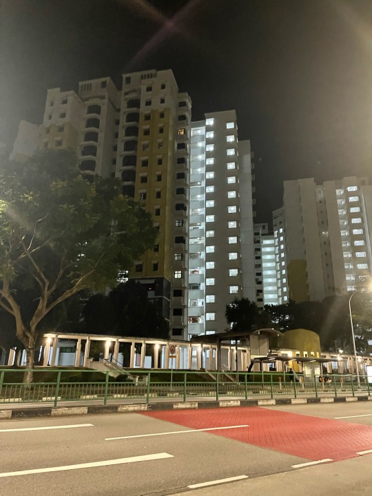
After the airport, we will go to my father's house. We took the MRT, but you can also take the bus. Our flight to the house takes more than 2 hours. We had four stops to change trains. There are different MRT lines in Singapore, but our line is the red line, better known as the NS (North-South Line). There is a map for each station that you can see, and it says how many hours or minutes it will take you to get to your destination.
When we got off at Sembawang Station, we found many stalls, food courts, and convenience stores. and after we cross, there's a mall, so you won't get bored and hungry there. When we left the mall, we saw the bus stop, but that was only an option because you can also walk to your house if you are close. In our case, we were at the end, so we took the bus. When we got off the bus, there was a food court, better known as Hawkers, and there was also a convenience store.
I just noticed that here in the Philippines, the driver is on the left side, while in Singapore, it is on the right side. Also, the people there are really disciplined because when they actually cross, it is only on the pedestrian line, and they wait for the green light before crossing.
That's it for my first day in Singapore.


7 notes
·
View notes
Photo
20220829 Day 122: Shop . . . . #singapore #asia #isaaccapture #paradise #beautifuldestinations #beautiful #wanderlust #travel #globetrekker #isaackiat #ik #wednesday #streetphotography #summer #ourplanetdaily #mrt #station #escalators #bnwphotography #perspective #2022 #surrealism #ssdttt #architecture #Leica #35mm (at Singapore / Singapura / 新加坡 / சிங்கப்பூர்) https://www.instagram.com/p/Cm0XirOSUaT/?igshid=NGJjMDIxMWI=
#singapore#asia#isaaccapture#paradise#beautifuldestinations#beautiful#wanderlust#travel#globetrekker#isaackiat#ik#wednesday#streetphotography#summer#ourplanetdaily#mrt#station#escalators#bnwphotography#perspective#2022#surrealism#ssdttt#architecture#leica#35mm
2 notes
·
View notes
Link
#new launch condo#singapore luxury property#singapore condo for sale#condo near mrt#freehold condo#new condo singapore
3 notes
·
View notes

Text
Singapore MRT Map: A Comprehensive Guide to Navigating the Network in 2024
1 note
·
View note
Text
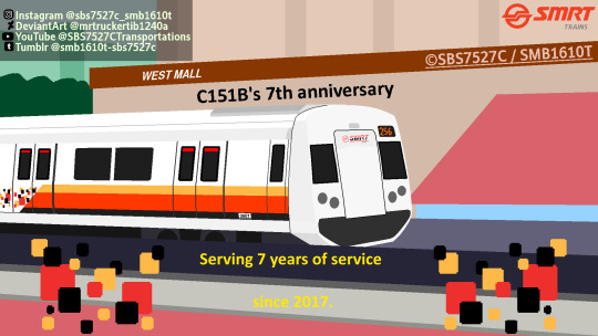
SMRT C151B 7th Anniversary
Spotted C151B's first unit 601/602 (TRN256) leaving Bukit Batok for Marina South Pier. Seen from Bukit Batok MSCP.
#art#train#train art#smrt#smrt trains#singapore#kawsakii crrc qingdao sifang#singapore trains#singapore train#singapore mrt#mrt#mrt trains#kawasaki#c151b#smrt c151b#kawasaki crrc qingdao sifang c151b
0 notes
Link
Danny Harmon on Distant Signal 📺 clued me into OpenRailwayMap, a OpenStreetMap-style site but for gl...
0 notes
Text
0 notes
Text
The Evolution of the MRT Line in Singapore: Enhancing Connectivity and Mobility
Singapore's Mass Rapid Transit (MRT) system has significantly evolved since its inception in 1987. The MRT line in Singapore has played a crucial role in transforming the city-state's transportation landscape, providing a reliable, efficient, and sustainable mode of travel for millions of commuters every day. Over the years, the MRT network has expanded to cover more ground, connecting various parts of the island and reducing the dependence on private vehicles.
The introduction of the North-South Line marked the beginning of Singapore's journey towards building a comprehensive MRT network. Subsequently, new lines such as the East-West Line, Circle Line, and Downtown Line were added to the system, expanding connectivity and improving access to key areas across the island. The planning and construction of these lines were driven by the government's vision to create a seamless and integrated public transportation network that caters to the diverse needs of Singaporeans.
One of the significant milestones in the evolution of the MRT line in Singapore was the completion of the North-East Line, which was the first fully automated underground line in the country. This technological advancement not only enhanced the efficiency of the MRT system but also set a new standard for urban transportation in the region. The continuous upgrades in train technology, station facilities, and operational processes have further elevated the overall commuting experience for passengers.
In recent years, the importance of sustainability and environmental conservation has become a key focus for Singapore's MRT system. Initiatives such as energy-efficient trains, regenerative braking systems, and solar panel installations have been implemented to reduce the network's carbon footprint and promote eco-friendly practices. These green initiatives not only benefit the environment but also contribute to creating a more livable and resilient city for future generations.
Looking ahead, the future of the MRT line in Singapore is poised for exciting developments. With upcoming projects like the Thomson-East Coast Line and Cross Island Line, the MRT network will continue to expand and evolve to meet the growing needs of the population. By incorporating smart technologies, improving connectivity to residential and industrial areas, and enhancing last-mile solutions, the MRT system is set to play an even more significant role in shaping Singapore's transportation ecosystem.
The evolution of the MRT line in Singapore reflects a commitment to enhancing connectivity, promoting sustainability, and improving the overall quality of life for residents. As the city-state continues to innovate and invest in its public transportation infrastructure, the MRT system will remain a vital pillar of Singapore's success story.
Significance of MRT Line Expansion for Singapore's Transportation System
The MRT line in Singapore has played a pivotal role in transforming the city-state's transportation landscape since its inception. With the continuous expansion of the MRT line network, Singapore has experienced numerous benefits that have significantly impacted its overall transportation system.
First and foremost, the expansion of the MRT line has helped alleviate the issue of traffic congestion on the roads. By providing a reliable and efficient alternative mode of transportation, more Singaporeans are encouraged to opt for the MRT, thus reducing the number of cars on the road. This reduction in traffic congestion not only leads to smoother traffic flow but also contributes to a decrease in carbon emissions, promoting a cleaner and greener environment.
Moreover, the MRT line expansion has enhanced connectivity across different parts of Singapore. As new MRT stations are added to the network, residents in various neighborhoods are offered greater accessibility to key amenities, businesses, and recreational areas. This improved connectivity not only benefits daily commuters but also boosts economic activity by facilitating the movement of people across the city more seamlessly.
Furthermore, the expansion of the MRT line reflects Singapore's commitment to sustainable urban development. By investing in public transportation infrastructure, the city-state is prioritizing the use of mass transit over private vehicles, promoting a more sustainable and eco-friendly mode of transportation. This shift towards a greener transportation system aligns with Singapore's goal of becoming a more environmentally conscious and sustainable city.
In addition to environmental benefits, the MRT line expansion also contributes to enhancing the overall quality of life for Singaporeans. With improved connectivity and accessibility, individuals are able to travel more efficiently and cost-effectively, saving both time and money in their daily commute. This increased convenience not only improves the daily commute experience but also enhances the overall well-being of residents by reducing travel-related stress and hassles.
The expansion of the MRT line in Singapore holds significant importance for the city-state's transportation system. With benefits ranging from reduced traffic congestion and enhanced connectivity to promoting sustainability and improving quality of life, the continuous expansion of the MRT line plays a crucial role in shaping Singapore's urban landscape for the better.
Green Initiatives Implemented in Singapore's MRT Line
As one of the most efficient and sustainable modes of transportation in Singapore, the MRT line plays a crucial role in the city-state's efforts to reduce carbon emissions and create a more environmentally friendly public transportation system. Over the years, various green initiatives have been implemented to enhance the sustainability of the MRT line and minimize its impact on the environment.
One of the key initiatives undertaken is the incorporation of energy-efficient technologies across the MRT network. From energy-efficient trains to regenerative braking systems that convert kinetic energy into electricity, these technologies help reduce energy consumption and decrease the overall carbon footprint of the MRT line.
In addition to technological advancements, Singapore's MRT line has also focused on incorporating sustainable practices in station design and operations. For instance, many MRT stations are equipped with natural ventilation systems and energy-efficient lighting to reduce electricity usage. Moreover, the integration of rooftop gardens and green spaces in some stations not only enhances the aesthetic appeal but also promotes biodiversity and improves air quality in urban areas.
Furthermore, the Singapore government has been actively promoting the use of public transportation through various incentives and initiatives. These include the introduction of the Green Mark Scheme, which certifies buildings—such as MRT stations—that meet specific environmental standards. By encouraging sustainable practices in station construction and operation, the government aims to create a more eco-friendly and energy-efficient public transport infrastructure.
Another critical aspect of green initiatives in Singapore's MRT line is waste management. Efforts to minimize waste generation, promote recycling, and reduce single-use plastics have been implemented in MRT stations and trains. By raising awareness about sustainable waste practices among commuters and staff, the MRT line contributes to Singapore's broader goals of achieving a zero-waste nation.
The implementation of green initiatives in Singapore's MRT line reflects the city-state's commitment to building a sustainable and eco-friendly public transportation system. By integrating energy-efficient technologies, promoting sustainable practices, and fostering a culture of environmental awareness, the MRT line continues to set an example for efficient and environmentally responsible urban transport systems.
#MRT line#Singapore's MRT line#mrt line singapore#singapore mrt line map#mrt map 2024#singapore mrt map 2024#sg mrt map 2024#purple line mrt map#mrt brown line#east west mrt line#thomson mrt line map
1 note
·
View note
Text
Cara Mudah Menuju National Stadium Singapura
CARA mudah menuju National Stadium Singapura, memang benar-benar mudah. Tersedia sejumlah moda transportasi untuk ke National Stadium Singapura.
Tinggal memilih saja, mana yang pas, paling nyaman, dan tentu, paling sesuai budget. Bisa naik MRT, bus, taksi, ojek online, bawa mobil sendiri, atau jalan kaki.
National Stadium Singapura merupakan stadion multiguna yang lokasinya di Kallang. Stadion…

View On WordPress
#cara ke national stadium singapore#cara ke national stadium singapura#konser coldplay di singapura#konser taylor swift di singapura#mrt kallang to national stadium#orchard road to national stadium
0 notes

Last Seen Blogs

justoneofthoseghosts
Can I sail through the changing ocean tides?

autodesk-keygen-gp
🔥 How To Use Keygen For Autocad

patterdrury
Liveaquaria

headinthestaticsky
Staticsky's writings

nastylmao
mmhh