#makeyoursplash
Photo


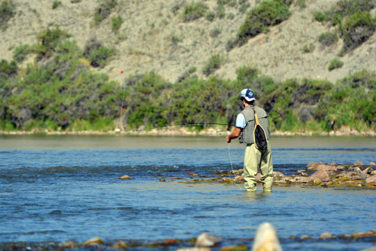
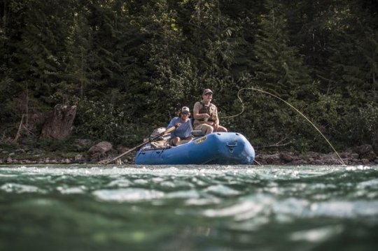
#FindYourWay and celebrate National Fishing and Boating Week!
It’s time to plan a summer adventure on your public lands to celebrate this year’s National Fishing and Boating Week!
The Bureau of Land Management manages over 130,000 miles of fishable rivers and streams and provides countless public recreational fishing and boating access opportunities throughout the United States. From desert reservoirs to mountain streams, BLM-managed fisheries and aquatic resources support public recreation and subsistence fisheries and are critical for sustaining the Nation’s aquatic resources and fisheries. BLM-managed public lands are open for fishing unless specifically closed for specific resource protection purposes.
Check out the list below to discover some of our favorite boating and fishing spots! Some of these spots are Wild and Scenic Rivers. This year marks the 50th anniversary of the Wild and Scenic Rivers Act. Learn more on our website, and start exploring!

Gulkana Wild and Scenic River, Alaska
The Gulkana River begins in the Alaska Range near Summit Lake and flows south into the Copper River, which eventually empties into the Gulf of Alaska between Cordova and Katalla. Several hundred lakes and ponds are scattered throughout the spruce-dominated forest of the Gulkana River watershed, providing abundant nesting areas for trumpeter swans and waterfowl.
Portions of the Gulkana River were designated for its wild character as part of the National Wild and Scenic River system. The BLM asks that all users do their part to help maintain the wild character of the Gulkana through low impact camping techniques.
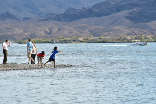
Lake Havasu, Arizona
Lake Havasu is a premier destination for water-based recreation, especially for boating enthusiasts and sport anglers.The BLM Arizona Lake Havasu Field Office maintains 87 boat-access-only campsites along the Lake Havasu shoreline, as well as a handful of day use areas and campgrounds south of Parker Dam on the California side of the Colorado River.
Recreationists will now be able to easily attain electronic recreation permits and annual passes for Lake Havasu shoreline sites through the digital marketplace, YourPassNow. More information available on our website.
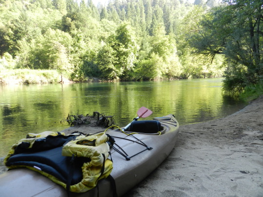
Trinity Wild and Scenic River, California
Popular with fisherman and pleasure boaters alike, the 43 miles of the Wild and Scenic Trinity River from Lewiston to Pigeon Point is a class I and II segment that flows out of the Trinity and Lewiston Lakes. This clear, cold section of the river is world famous for its fly fishing. Paddlers enjoy the narrow valley with Ponderosa Pine, Douglas fir, Oaks, and Madrone trees coating the walls of the canyons. If you would like more adrenaline rush, the waters below Pigeon Point rage at class III-V. Those interested in a more relaxing experience can enjoy the abundant camping options in the area or head for the trail with your friends, horses, or dog. If you would like to stay at the river's edge, you can always swim, fish or do a little gold panning. The river can be accessed from many locations along this stretch of the Trinity River.
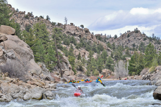
Arkansas Headwaters Recreation Area, Colorado
The Arkansas River is one of the most popular river-rafting spots in the United States. The area also provides some of the best fishing in Colorado. The spectacular scenery is highlighted by the steep, narrow, rocky canyons that provide excellent opportunities to view Rocky Mountain bighorn sheep. There are over 25 developed river-access areas. Popular activities include rockhounding at Ruby Mountain, fishing for brown trout at Hecla Junction, and wildlife-watching at the Five Points Watchable Wildlife Area in Bighorn Sheep Canyon. The area is jointly managed by the BLM and Colorado Parks and Wildlife.

South Fork of the Snake River, Idaho
The South Fork of the Snake River flows for 66 miles across southeastern Idaho, through high mountain valleys, rugged canyons, and broad flood plains to its confluence with the Henrys Fork of the Snake near the Menan Buttes. It flows northwest from Palisades Dam in Swan Valley. For the first nine miles, the river runs through a narrow channel, then widens and flows around several island complexes. A waterfall can be seen just upstream from the Swan Valley Bridge where Fall Creek cascades into the river. Downstream of Conant launch the river leaves Highway 26 and enters a scenic canyon. The impressive canyon scenery continues downstream until near Heise Hot Springs the cliffs give way to a level, but extremely dynamic, flood plain.
Upper Missouri National Wild and Scenic River, Montana
The Missouri is the longest river in the United States, flowing more than 2,500 miles from its source on the eastern slope of the Rockies near Three Forks, Montana, to its confluence with the Mississippi River at St. Louis, Missouri. Congress designated 149 miles of the Upper Missouri as a component of the National Wild and Scenic River System in 1976, calling it an irreplaceable legacy of the historic American west. The Upper Missouri National Wild and Scenic River section starts at Fort Benton, Montana, and runs 149 miles downstream ending at the James Kipp Recreation Area.
49 species of fish (ranging from 1/2-oz. minnows to 140 lb. paddlefish) reside in the river. Fishermen are most likely to catch goldeye, drum, sauger, walleye, northern pike, channel catfish, carp and smallmouth buffalo.
For the family who plays together, the Upper Missouri caters to boaters of all degrees, from the beginning novice to the expert paddler to the leisurely motor boat aficionado. Visitors embark into a capacious river corridor that seemingly swallows even the largest groups and are treated to a remoteness not often found in the 21st Century.

Pine Forest Recreation Area, Nevada
The Pine Forest Range, in northern Nevada's arid Great Basin, is a rare and exceptional area of abundant streams and clear, cold subalpine lakes. Nestled in a cirque and fed by snowmelt and springs, these lakes are not only visually stunning but also possess an excellent trout fishery. The lakes are surrounded by a rare remnant population of white bark and limber pines; stands of quaking aspen and mountain mahogany are also found throughout the area. Fall brings a riot of color found in few other places in northern Nevada.

Gila Lower Box Canyon, New Mexico
The Gila Lower Box Canyon is a true oasis in the desert, 20 miles north of Lordsburg, New Mexico. Since livestock were removed from the river canyon in 1990, a lush native community of cottonwood, willows, and other riparian and aquatic vegetation has re-established and flourished. The area provides some of the best birding in New Mexico. Home to approximately 200 species, it has one of the highest bird diversities in the state. The area provides habitat to many rare and unusual birds including Bell's vireo, peregrine, bald eagle (in winter), golden eagle, black hawk, zone-tail hawk, gray hawk, yellow-billed cuckoo, Gila wood pecker, and Abert's towhee. The river provides opportunities for canoeing or rafting during spring runoff, hunting, and year-round fishing and camping. The river contains smallmouth bass and several species of catfish.

Quartzville Creek Wild and Scenic River, Oregon
Tranquility and water both flow in the wild and scenic Quartzville Creek, where one may hike, camp, fish or simply gaze into the mesmerizing, cascading waters. Quartzville Creek is named for the gemstone that has been mined in the area and a ghost town that was once the center of two brief gold mining efforts in the late 1800s.

Birch Creek Reservoir, Utah
Birch Creek Reservoir is a day-use fishing access site with public parking and toilet facilities adjacent to an excellent tiger trout fishery at the foot of the Monte Cristo Mountains in Rich County, UT. The site is located 10 miles west of Woodruff, UT off State Route 39. Access to the reservoir is walk-in only, non-motorized watercraft only. No fees are charged.

Wisconsin Islands, Wisconsin
Wisconsin, famed for its 84,000 miles of rivers that meander through varying terrain and its 15,000 lakes, is full of places to paddle, float, and fish. Many islands in this region were omitted from the original land surveys conducted in the 1830s and 1840s. Because of this, there is a mixing of ownership between state-owned, privately owned islands. For those under federal management, the BLM - Eastern States administers to almost 500 islands throughout the area. Because of this varied ownership, it's critical that visitors determine whether an island is public land before using it.
The flowages between Stevens Point and Nekoosa are chock-full of more than 60 public islands, ranging from small, low patches of willows and alder, to large stands of mixed pines and hardwoods. Below Castle Rock Lake, the islands down to Prairie du Sac are mostly floodplain forests with broad sandbars that invite paddler-campers. A few of these islands have remnant prairie and savanna vegetation.
Many public islands are perfect fishing spots, lunch stops for your next float trip, or overnight campsites. However, there are no visitor services at any of these locations; as such, it is important to plan accordingly. If you have any questions about visiting the islands, please call (414) 297-4400.
Check out the Wisconsin Islands ESRI story map to learn more about these hidden gems.
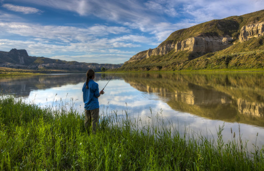
North Platte River, Wyoming
The North Platte River is the only floatable waterway in central Wyoming and has become the destination fishery for the state. Scenic and recreational values of the North Platte River are derived from a combination of environmental factors and management practices. The river is highly valued as a class 1 fishery. The Wyoming Game and Fish Department has rated it as a blue ribbon fishery. Game fish species include rainbow, brown and cutthroat trout. The most common recreation activities are fishing, floating, waterfowl hunting, and observing wildlife. There are also opportunities for picnicking and camping. This river has become a vital part of the social and economic values of central Wyoming.
ll anglers on public lands must have the required state license(s). That’s because states are responsible for managing wildlife within their borders for the trust and benefit of their residents, even if the hunting occurs on federal lands. You can search for state fishing licenses on the U.S. Fish & Wildlife Service website.
For more river trips ideas, check out the Department of the Interior’s blog!
#FindYourWay#find your way#fishing#boating#recreation#yourpubliclands#wildlife#adventure#discovery#outdoors#water#road trip#bureau of land management#wild and scenic rivers#rivers#makeyoursplash
57 notes
·
View notes
Photo
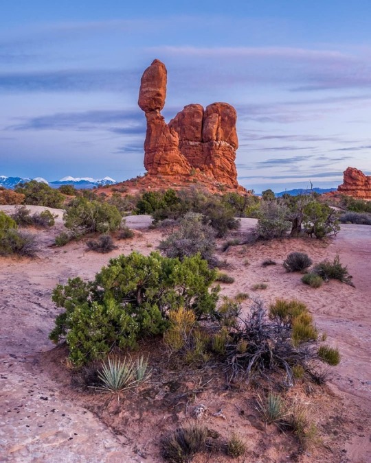
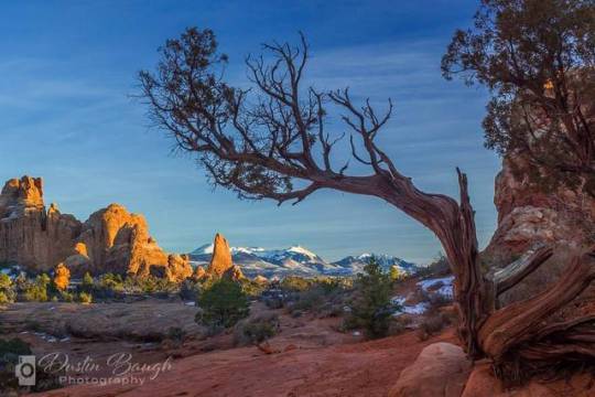
. . . . . #ArchesNP #WindowsSection #BalancedRock #PulloutChallenge #Slickrock #Redrock #The59Parks #FindYourPark #GoParks #fypyes #Nationalparkgeek #MightyFive #nps #nationalparks #americasbestidea #nationalparkfoundation #npca #nationalparktrust #protectourpubliclands #loveyourresource #utahnps #MakeYourSplash #FindYourTrail #pictureline (at Balanced Rock) https://www.instagram.com/p/Bq1CiCun8M9/?utm_source=ig_tumblr_share&igshid=z37nhjt13b10
#archesnp#windowssection#balancedrock#pulloutchallenge#slickrock#redrock#the59parks#findyourpark#goparks#fypyes#nationalparkgeek#mightyfive#nps#nationalparks#americasbestidea#nationalparkfoundation#npca#nationalparktrust#protectourpubliclands#loveyourresource#utahnps#makeyoursplash#findyourtrail#pictureline
0 notes
Text
RT @forestservice: Today marks the 50th anniversary of the Wild and Scenic Rivers Act and the National Trails Act! Celebrate these milestones by visiting your national forests and grasslands and exploring the amazing areas preserved by these two acts. #FindYourTrail #MakeYourSplash https://t.co/zfASanompj
Today marks the 50th anniversary of the Wild and Scenic Rivers Act and the National Trails Act! Celebrate these milestones by visiting your national forests and grasslands and exploring the amazing areas preserved by these two acts. #FindYourTrail #MakeYourSplash pic.twitter.com/zfASanompj
— U.S. Forest Service (@forestservice) October 2, 2018
via Twitter https://twitter.com/TerryCanales40
October 02, 2018 at 02:17PM
0 notes
Photo

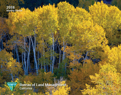
Enjoy the beauty of California all year long with a 2018 planner!
The Bureau of Land Management manages 15 million acres of public lands in California - nearly 15 percent of the state - and 1.6 million acres in northwestern Nevada. This year’s monthly planner features stunning public lands across the state with impressive employee photography. Get your FREE planner while supplies last.
#California#Nevada#public lands#nature#landscape#calendar#photography#nature photography#outdoors#outdoor photography#beauty#FindYourWay#MakeYourSplash#MondayMotivation
96 notes
·
View notes
Photo
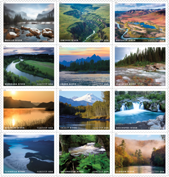
2019 USPS stamps to feature BLM-managed wild and scenic rivers
Thanks to the U.S. Postal Service for featuring 4 BLM-managed rivers in their 2019 stamp lineup dedicated to highlighting wild and scenic rivers: Merced River, Owyhee River, Snake River and Deschutes River. The BLM manages 69 Wild and Scenic Rivers across seven states, which includes the management of over 2,400 river miles. #FindYourWay #MakeYourSplash
Read more: about.usps.com/newsroom/national-releases/2018/pr18_095.htm
#Find your way#make your splash#rivers#wild and scenic rivers#stamps#bureau of land management#public lands
137 notes
·
View notes
Photo
@forestservice: Many of the wild and scenic rivers managed by the USDA Forest Service offer an incredible spectrum of recreational opportunities that range from fly #fishing to whitewater boating to places where you can simply cool off and sit in quiet. #MakeYourSplash https://t.co/PSqPqIByzz
0 notes
Photo
I'll be honest. Half the resaon I took this picture was a reminder to myself to return on my official April trip to see what it looks like in the morning with the sun on the otherside. . . . . . #ArchesNPS #Windows #SouthWindow #LaSalMountains #Redrock #Winter #VisitUtah #NaturalUtah #UtahUnique #XPUtah #DiscoverUtah #UtahGram #WowUtah #weRutah #Beutahful #Utahdotcom #weUtah #The59Parks #FindYourPark #GoParks #Nationalparkgeek #MightyFive #nps #nationalparks #americasbestidea #nationalparkfoundation #everykidinapark #npca #nationalparktrust #protectourpubliclands #climatechangeisreal #loveyourresource #utahnps #MakeYourSplash #FindYourTrail (at South Window, Arches Nation Park)
#utahunique#makeyoursplash#everykidinapark#wowutah#npca#protectourpubliclands#southwindow#nationalparktrust#naturalutah#werutah#nationalparkfoundation#nationalparkgeek#americasbestidea#goparks#mightyfive#archesnps#utahnps#discoverutah#windows#beutahful#nps#visitutah#findyourpark#findyourtrail#redrock#utahgram#the59parks#lasalmountains#utahdotcom#loveyourresource
0 notes
Last Seen Blogs

sop-soap
Soctor Soctopus


mariam05sworld
BLOG DE MARIAM

hianonsuper
Untitled
sop-soap
Soctor Soctopus