#earthscience
Text
Source: LEARN Geology
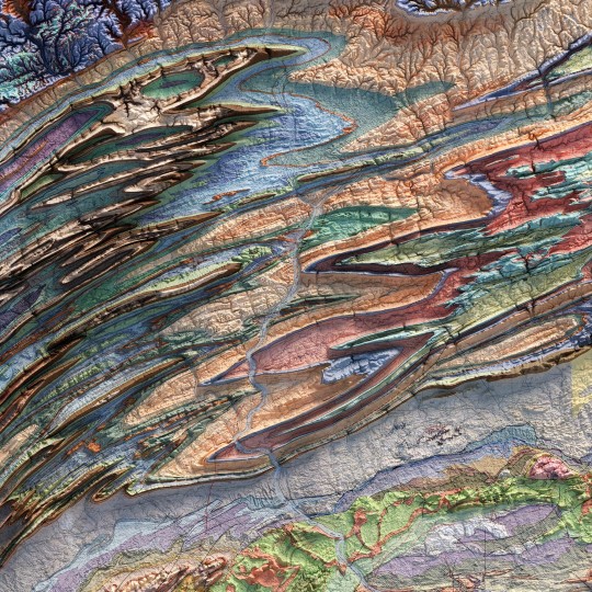
𝗠𝗮𝗿𝗶𝗻𝗲 𝗟𝗶𝗺𝗲𝘀𝘁𝗼𝗻𝗲: 𝗧𝗵𝗲 𝗛𝗶𝗴𝗵𝗲𝘀𝘁 𝗥𝗼𝗰𝗸𝘀 𝗶𝗻 𝘁𝗵𝗲 𝗣𝗹𝗮𝗻𝗲𝘁
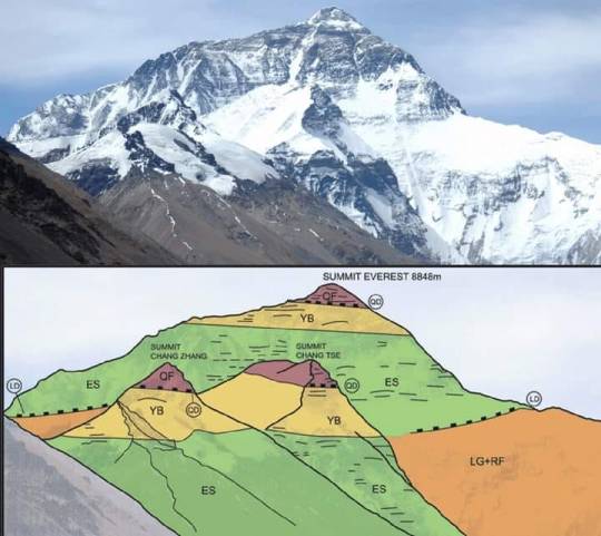
Everest Range, 𝗡𝗲𝗽𝗮𝗹 and 𝗧𝗶𝗯𝗲𝘁, 𝗖𝗵𝗶𝗻a
27°59'17"N / 086°55'30"E
𝙂𝙚𝙤𝙡𝙤𝙜𝙞𝙘𝙖𝙡 𝙋𝙚𝙧𝙞𝙤𝙙:
Middle 𝗢𝗿𝗱𝗼𝘃𝗶𝗰𝗶𝗮𝗻 (𝗗𝗮𝗿𝗿𝗶𝘄𝗶𝗹𝗶𝗮𝗻)
𝘿𝙚𝙨𝙘𝙧𝙞𝙥𝙩𝙞𝙤𝙣:
Mount Everest is 𝗘𝗮𝗿𝘁𝗵'𝘀 𝗵𝗶𝗴𝗵𝗲𝘀𝘁 𝗺𝗼𝘂𝗻𝘁𝗮𝗶𝗻 above sea level, located in the Mahalangur Himal sub-range of the Himalayas. The China–Nepal border runs across its summit point. Its elevation of 𝟴,𝟴𝟰𝟴.𝟴𝟲 𝗺 was most recently established in 2020 by the Chinese and Nepali authorities.
𝗚𝗲𝗼𝗹𝗼𝗴𝗶𝗰𝗮𝗹 𝗗𝗲𝘀𝗰𝗿𝗶𝗽𝘁𝗶𝗼𝗻:
The 𝘀𝘂𝗺𝗺𝗶𝘁 of Mount Everest, the 𝗵𝗶𝗴𝗵𝗲𝘀𝘁 𝗽𝗼𝗶𝗻𝘁 on Earth, was a 𝘀𝗲𝗮 𝗳𝗹𝗼𝗼𝗿 once. 𝗜𝘀𝗻'𝘁 𝘄𝗼𝗻𝗱𝗲𝗿𝗳𝘂𝗹?. The highest rock on Earth, marking the summit of Mount Everest, are 𝗢𝗿𝗱𝗼𝘃𝗶𝗰𝗶𝗮𝗻 𝗟𝗶𝗺𝗲𝘀𝘁𝗼𝗻𝗲𝘀, deposited in a warm, shallow water sea some 𝟰𝟱𝟬 𝗠𝗮 𝗮𝗴𝗼.
These rocks deposited in an 𝗮𝗻𝗰𝗶𝗲𝗻𝘁 𝗧𝗲𝘁𝗵𝘆𝗮𝗻 𝗢𝗰𝗲𝗮𝗻 were thrust and 𝘂𝗽𝗹𝗶𝗳𝘁𝗲𝗱 into their present commanding position when 𝗜𝗻𝗱𝗶𝗮𝗻 𝗽𝗹𝗮𝘁𝗲 𝗰𝗼𝗹𝗹𝗶𝗱𝗲𝗱 with the 𝗔𝘀𝗶𝗮𝗻 𝗰𝗼𝗻𝘁𝗶𝗻𝗲𝗻𝘁 some 𝟱𝟱 𝗺𝗶𝗹𝗹𝗶𝗼𝗻 𝘆𝗲𝗮𝗿𝘀 𝗮𝗴𝗼.

𝗤𝗙: 𝗤𝗼𝗺𝗼𝗹𝗮𝗻𝗴𝗺𝗮 𝗙𝗼𝗿𝗺𝗮𝘁𝗶𝗼𝗻 (𝗘𝘃𝗲𝗿𝗲𝘀𝘁 𝗹𝗶𝗺𝗲𝘀𝘁𝗼𝗻𝗲𝘀):
It is the un-metamorphosed layer of limestone here called ‘QF’ for 𝗤𝗼𝗺𝗼𝗹𝗮𝗻𝗴𝗺𝗮 𝗙𝗼𝗿𝗺𝗮𝘁𝗶𝗼𝗻, which forms the 𝘀𝘂𝗺𝗺𝗶𝘁 of Everest. It is separated from the underlying Yellow Band layer by a low angle detachment fault.
𝗬𝗕:𝗬𝗲𝗹𝗹𝗼𝘄 𝗕𝗮𝗻𝗱:
This is the layered bedding. It is a limestone, formed from a shallow marine sediment, heated to become a 𝗺𝗮𝗿𝗯𝗹𝗲.
𝗘𝗦: 𝗘𝘃𝗲𝗿𝗲𝘀𝘁 𝗦𝗲𝗿𝗶𝗲𝘀:
It consists of 𝘀𝗲𝗱𝗶𝗺𝗲𝗻𝘁𝗮𝗿𝘆 rock which has been metamorphosed at reasonably high temperatures. It is separated from the underlying layer by a low angle almost horizontal fault.
𝗥𝗙: 𝗥𝘂𝗻𝗴𝗯𝗼𝗸 𝗳𝗼𝗿𝗺𝗮𝘁𝗶𝗼𝗻:
The Rungbok Formation consists of ‘LG’ Leuco- granite and gneiss.RF is a gneiss: rock partly melted and metamorphosed under high temperatures.
𝙁𝙤𝙨𝙨𝙞𝙡𝙨:
These rocks still contain the fossils of marine animals such as 𝗕𝗿𝗮𝗰𝗵𝗶𝗼𝗽𝗼𝗱𝘀, 𝗖𝗼𝗻𝗼𝗱𝗼𝗻𝘁𝘀 and 𝗖𝗿𝗶𝗻𝗼𝗶𝗱𝘀 that occupied tropical habitats during one of the most 𝗶𝗺𝗽𝗼𝗿𝘁𝗮𝗻𝘁 𝗶𝗻𝘁𝗲𝗿𝘃𝗮𝗹𝘀𝗹𝘀 in 𝗘𝗮𝗿𝘁𝗵'𝘀 history, the 𝗚𝗿𝗲𝗮𝘁 𝗢𝗿𝗱𝗼𝘃𝗶𝗰𝗶𝗮𝗻 𝗕𝗶𝗼𝗱𝗶𝘃𝗲𝗿𝘀𝗶𝗳𝗶𝗰𝗮𝘁𝗶𝗼𝗻 𝗘𝘃𝗲𝗻𝘁 (𝗚𝗢𝗕𝗘).
#himalayan#mounteverest#ordovician#limestone#nepal#india#tibet#indianplate#eurasianplate#geology#thrust#stratigraphy#sedimentology#petrology#structuralgeology#tethys#earthscience#iugs#unesco#geoheritage#knowledge
32 notes
·
View notes
Text
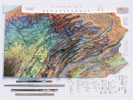
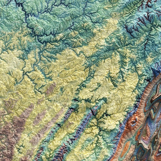
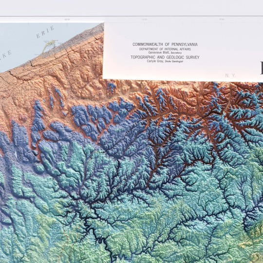
From the 1960s, a (restored) school geological map of Pennsylvania, obviously with shaded relief!
🗺️ 𝗠𝗔𝗣 𝗜𝗡𝗙𝗢
Geologic map of Pennsylvania, Topographic and Geologic Survey, Commonwealth of PA, 1960.
Source: David Rumsey Collection.
If you like our work, want to see our daily updates (or want to say hello to our studio), consider to follow our Instagram or Twitter account. Otherwise if are interested in our prints or have a custom request check our shop.
#Pennsylvania#pittsburgh#usmap#mapdesign#GeologyPA#VintageMap#PennsylvaniaHistory#ShadedRelief#GeologicHeritage#PAExploration#RockFormation#GeologicalTreasure#EarthScience#PennsylvaniaGeology#GeologicWonders#LandscapeHistory#GeologicalArt#ElevationData#GeologicMapping#BedrockGeology#NaturalHistory#GeospatialData#GeologicFeatures#MapArt#vizart
4 notes
·
View notes
Photo

I go outside sometimes. #outdoors #camping #work #geology #outside #canoeing #canoe #portage #backcountry #wolflake #photography #earth #earthscience #lgbt (at Lake Temagami) https://www.instagram.com/p/CiITn-6uQSQ/?igshid=NGJjMDIxMWI=
#outdoors#camping#work#geology#outside#canoeing#canoe#portage#backcountry#wolflake#photography#earth#earthscience#lgbt
26 notes
·
View notes
Text
He said “rocks or me”
Sometimes I think about him when I check my new rock collection.
#geology#geotumblr#geodude#geouni#uni#unilife#earth#earthscience#geoscience#nerdjokes#nerd#geonerd#geologynerd#university#geogirl#relationship#geolove#geologyblr#geo#newme
9 notes
·
View notes
Photo

The Astral Ammonite by @ashatanktattoo For my forearm tattoo, I wanted something that blended my ¹ I'm natural history, earth sciences & astronomy. The spiral galaxy forms the shell of the Ammonite, while the 12 stars in the constellation within it represent the 12 major eras of life on Earth (Cambrian, Jurassic, Neogene etc). Ft. Fluff-butt #tattoo #tattoos #naturalhistory #earthscience #space #astronomy #fossil #fossils #prehistoric #shell #constellation #star #dotwork #science #nature #dog #keeshond https://www.instagram.com/p/ClMJ6y1DMyT/?igshid=NGJjMDIxMWI=
#tattoo#tattoos#naturalhistory#earthscience#space#astronomy#fossil#fossils#prehistoric#shell#constellation#star#dotwork#science#nature#dog#keeshond
6 notes
·
View notes
Photo
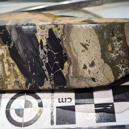
These rocks have all experienced hydrothermal alteration and contact metamorphism. The 1.4 billion year old Velkerri Formation from Australia is an organic rich mudstone. Some time after burial and lithification, the rock was intruded by hydrothermal fluids that caused metallic sulphide, and ferrous carbonate + quartz mineralisation. I think some maybe related to the intrusion of dolerite around 1.2 billon years ago, and some related to basin inversion around 800 million years ago. The mineralisation and contact metamorphism is widespread but in some areas is subtle and only visible on the microscopic scale. The velkerri formation is the basis for much of what we know about marine chemistry during the early evolution of eukaryotic life. Several important geochemical studies sampled the velkerri formation and used the pyrite in particular to show that the oceans 1.4 billion years ago were low in oxygen and rich in sulphur. This environmental state is thought to have been a major barrier to the development of more complex eukarotes. However, the hydrothermal and contact metamorphic alteration, in particular the micro scale alteration were unknown when these studies were conducted. As these previous studies used bulk sampling methods, it's likely that they unknowingly sampled the later sulphides which will have influenced the results and the interpretations of the previous researchers. This does not mean the previous work is bad and should be disregarded. Simply that the results should be reinterpreted inlight of this new information. That is how science is supposed to work. It is self revising and correcting. That is how science advances and improves. However, getting paper reviewers to understand and accept this is another thing entirely. I'm currently revising this work after a rejection. So let's see if the next version is enough to get the paper out. 😉 #geologyjohnson #geology #geologyrocks #pyrite #blackshale #shale #ore #hydrothermal #igneous #dolerite #metamorphism #science #sciencerocks #earthscience #naturalhistory https://www.instagram.com/p/CdaMy8-sFoZ/?igshid=NGJjMDIxMWI=
#geologyjohnson#geology#geologyrocks#pyrite#blackshale#shale#ore#hydrothermal#igneous#dolerite#metamorphism#science#sciencerocks#earthscience#naturalhistory
7 notes
·
View notes
Text
Science Classes in Singapore: Explore the wonders of science through engaging classes covering physics, chemistry, biology, and more. Hands-on experiments and interactive learning foster curiosity and scientific inquiry.
#ScienceClasses#SingaporeScience#STEMeducation#ScienceEducation#SingaporeEducation#ScienceSkills#SingaporeStudents#ScienceCourses#ScienceLearning#STEMlearning#SingaporeLearning#Biology#Chemistry#Physics#EarthScience#LifeSciences#PhysicalSciences#Experimentation#HandsOnLearning#EducationForAll#ScientificDiscovery
0 notes
Photo
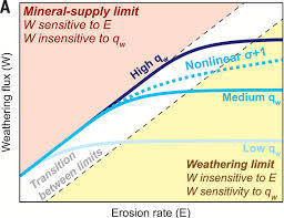
CO2 Drawdown from Weathering: A Geological Insight | CeBoz.com
CO2 Drawdown from Weathering: A Geological Insight
0 notes
Text
Ignite curiosity and exploration with Kiya Learning's online science classes in Singapore. we are aligned with Singapore curriculum standards, Kiya Learning courses cover biology, chemistry, physics, and environmental science. Engage in hands-on experiments and interactive sessions to deepen your understanding of the natural world.
#ScienceClass#STEMeducation#ScienceEducation#STEMlearning#BiologyClass#ChemistryClass#PhysicsClass#EarthScience#EnvironmentalScience#ScienceTeacher#STEMteacher#ScienceLab#ScientificMethod#Experimentation#ScienceFair#STEMcurriculum#ScienceResources#ScienceExperiments#STEMclub#ScienceCommunication
0 notes
Text
PACE Mission: Earth’s Oceans and Atmosphere Under Intensive Scrutiny

A Billion-Dollar Mission Survives Setbacks
In a testament to resilience, the nearly billion-dollar mission to explore Earth’s oceans and atmosphere, known as PACE (Plankton, Aerosol, Cloud, ocean Ecosystem), is set to launch from Cape Canaveral’s Space Launch Complex 40 on February 6 at 1:33 a.m. Eastern. Despite multiple cancellation attempts during its development, the mission, carried by a Falcon 9, has persisted and is ready for liftoff.
PACE’s Scientific Payload: A Comprehensive Study of Oceans and Atmosphere
(Plankton, Aerosol, Cloud, ocean Ecosystem), carries a suite of three instruments designed to scrutinize the ocean, clouds, and aerosols in the atmosphere. The Ocean Color Instrument (OCI), the primary tool, will provide comprehensive information on ocean color across ultraviolet to infrared wavelengths. Accompanying OCI are the Hyper Angular Research Polarimeter (HARP2) and Spectro-polarimeter for Planetary Exploration (SPEXone), dedicated to collecting data on atmospheric clouds and aerosols while supporting the atmospheric correction of OCI data.
Karen St. Germain, director of NASA’s Earth Science division, expressed excitement about PACE’s potential, stating, “(Plankton, Aerosol, Cloud, ocean Ecosystem), is going to so profoundly advance our understanding about how our oceans work and how they are related to the broader Earth system and the changing climate.”
Focus on Phytoplankton and Collaborative Earth Science Missions
PACE’s key focus is studying phytoplankton on the ocean surface, with the ability to differentiate among various species. Jeremy Werdell, (Plankton, Aerosol, Cloud, ocean Ecosystem), project scientist, highlighted the mission’s capability to identify harmful and beneficial phytoplankton, providing crucial insights into their distribution and movements. PACE’s data will be complemented by other Earth science missions, such as the Surface Water and Ocean Topography (SWOT) spacecraft, offering a comprehensive understanding of ocean dynamics.
Overcoming Budget Hurdles: PACE’s Long, Strange Trip
(Plankton, Aerosol, Cloud, ocean Ecosystem), faced numerous challenges, including proposed budget cuts by the Trump administration, with all four fiscal year proposals from 2018 to 2021 seeking its cancellation. Despite these setbacks, Congress consistently rejected the cuts, reaffirming its commitment to the mission. Andy Sayer, PACE atmospheric scientist, emphasized the mission’s importance, stating, “It has been a long, strange trip,” while Karen St. Germain expressed gratitude for the support from the stakeholder community that enabled the company to overcome budgetary obstacles.
As PACE embarks on its mission, scientists anticipate groundbreaking insights into Earth’s oceans and atmosphere, with data contributing to a broader understanding of climate change and environmental dynamics. The mission’s expected design life of three years may extend beyond, offering a prolonged period of scientific exploration.
0 notes
Text
#MagneticMysteries#EarthScience#GeomagneticField#ScienceExploration#SouthernHemisphereResearch#InnovationInScience#Paleomagnetism
0 notes
Text
How research in Antarctica will help to decode the secrets of our planet
RT - Edge of the World: How research in Antarctica will help to decode the secrets of our planet:
#antarctica#bharati#maitri#isro#expedition#climaticchange#weather#goldnanoparticles#earthscience#glaciology#geology
0 notes
Text
🌊 Revealing The Denmark Strait: The Greatest Underwater Waterfall on Earth
Hidden beneath the frigid waters of the North Atlantic Ocean lies a natural wonder of epic proportions - the Denmark Strait, often referred to as the "Greatest Underwater Waterfall on Earth." This awe-inspiring phenomenon is not your typical cascading waterfall, but rather an incredible display of oceanographic forces that occur between Greenland and Iceland. In this article, we will dive deep into the captivating story of the Denmark Strait and uncover the science behind its mesmerizing beauty.
The Geography of the Denmark Strait
Located in the North Atlantic Ocean, the Denmark Strait is a narrow passage that separates Greenland, the world's largest island, from Iceland, the land of fire and ice. This waterway, about 300 miles (483 kilometers) long and 180 miles (290 kilometers) wide, connects the Arctic Ocean to the east with the Atlantic Ocean to the west. The strait plays a vital role in the exchange of water masses and heat between these two major bodies of water.
The Underwater Waterfall Effect
What makes the Denmark Strait truly extraordinary is its unique hydrological feature - the "underwater waterfall." Unlike a traditional waterfall where water plunges from a height, this underwater cascade occurs due to differences in temperature and salinity between the two oceanic layers.
In the Denmark Strait, the surface waters from the Atlantic Ocean are relatively warm and less dense, while the deep waters from the Arctic Ocean are much colder and denser. When these two contrasting water masses meet, the cold, dense Arctic water dives below the warmer, lighter Atlantic water, creating a mesmerizing downward flow that mimics the appearance of a waterfall.
The Power of Nature
The sheer scale and power of the Denmark Strait are mind-boggling. The flow rate of water through the strait can be greater than the combined flow of all the world's rivers. It is estimated that more than 5 million cubic meters of water per second pass through the strait during its most active periods. To put that into perspective, it's roughly 200 times the flow rate of the Amazon River, the world's largest river.
Impact on Climate
The Denmark Strait's churning waters play a crucial role in global ocean circulation and climate regulation. As cold, nutrient-rich water from the Arctic Ocean rises to the surface during the mixing process, it promotes the growth of phytoplankton, the foundation of marine food chains. This, in turn, has a significant impact on the entire marine ecosystem in the North Atlantic.
Moreover, the heat exchange between the Arctic and Atlantic Oceans via the Denmark Strait has broader implications for global climate patterns. It contributes to the transport of heat from the equator towards the Arctic, helping to moderate temperatures in the northern regions and influencing weather systems worldwide.
Scientific Exploration
Unveiling the mysteries of the Denmark Strait has been a long-standing goal of oceanographers and marine scientists. They use advanced technologies such as autonomous underwater vehicles (AUVs) and remotely operated vehicles (ROVs) to study the intricate dynamics of the strait. These tools allow researchers to collect data from the depths and provide valuable insights into the ocean's behavior.
Protecting the Denmark Strait
The Denmark Strait's delicate balance is vulnerable to the effects of climate change. As global temperatures rise, the Arctic Ocean warms, potentially altering the strait's dynamics and the broader oceanic circulation patterns. It is vital to monitor these changes closely and take measures to protect this natural wonder, as it plays a vital role in the Earth's climate system.
A Source of Inspiration
The Denmark Strait, hidden beneath the waves, serves as a reminder of the Earth's incredible natural forces and the interconnectedness of our planet's systems. Its awe-inspiring beauty and profound influence on the global climate make it a source of inspiration for scientists and nature enthusiasts alike.
The Denmark Strait is a testament to the wonders that remain undiscovered within our oceans. As we continue to explore and study this remarkable phenomenon, we gain a deeper understanding of the intricate mechanisms that shape our world.
Let us celebrate and protect the Denmark Strait, ensuring that future generations can marvel at its majesty and appreciate the vital role it plays in maintaining the health of our planet.
#DenmarkStrait#UnderwaterWaterfall#Oceanography#ArcticOcean#ClimateChange#MarineScience#NaturalWonders#GlobalCirculation#EnvironmentalProtection#ScientificExploration#ClimateRegulation#NorthAtlantic#ArcticEcosystem#OceanCurrents#EarthScience#NatureInspiration#OceanConservation#OceanWonders#HiddenMarvels#ProtectOurOceans
0 notes
Text
Nature in Motion: Tectonics and Meteorites
Meteorological Records, Hurricanes, Floods, Tornadoes

Our planet is a dynamic sphere constantly shaped by geological forces and atmospheric phenomena. From meteorological records pushing the boundaries of weather extremes to the immense power of hurricanes, the destructive force of floods, and the mesmerizing yet formidable tornadoes, nature is in perpetual motion.
1. Meteorological Records:
Extreme Temperatures: Meteorological records showcase the Earth's climatic diversity, from scorching highs to freezing lows. Understanding these extremes helps us adapt to changing weather patterns.
2. Hurricanes:
Formation and Impact: These colossal storms, born over warm ocean waters, demonstrate the immense energy stored in the atmosphere. Studying hurricanes is crucial for predicting and mitigating their devastating effects.
3. Floods:
Natural and Human-Induced Causes: Floods result from a complex interplay of natural factors and human activities. Managing flood risks requires a comprehensive understanding of both.
4. Tornadoes:
Formation and Characteristics: Tornadoes, with their swirling funnels of wind, are among nature's most powerful and awe-inspiring phenomena. Unraveling their dynamics enhances our ability to forecast and respond to these events.
As we explore the relentless motion of nature, we gain insights into the Earth's dynamic processes. The study of tectonics, meteorites, and meteorological phenomena unveils the intricate ballet of elements that shapes our world.
0 notes
Text
youtube
Join us on an extraordinary journey to Baffin Island, where scientists have uncovered a remarkable secret hidden deep within Earth's core. Helium-3, a rare cosmic element, has been quietly leaking to the surface for eons. Discover the implications of this groundbreaking discovery and explore the mysteries of our planet's formation and evolution. Don't miss this fascinating revelation! Like, share, and subscribe for more captivating science stories.
#EarthScience#GeologicalDiscovery#BaffinIsland#Helium3#DeepEarthSecrets#ScientificRevelation#PlanetaryFormation#VolcanicRocks#CosmicElements#GeologicalResearch#MysteryOfTheCore#ScienceExploration#NaturalWonders#ScienceFacts#AncientEarth#SolarSystemOrigins#GeologicalTreasures#HeliumLeakage#EarthHistory#MantlePlumes#PlanetaryEvolution#HiddenEarthSecrets#BaffinExpedition#ScientificDiscovery#SubscribeForMore#Youtube
0 notes
Text
Unlocking the concept of Heat vs. Temperature and Earth's Temperature Factors
youtube
In this enlightening video, we delve into the fascinating world of heat and temperature. 🌡️ Discover the key distinctions between these two fundamental concepts and gain a deeper understanding of their significance in our everyday lives. Join us on a journey across the globe as we explore the various factors that influence temperature variations in different places on Earth. 🌍 From geographic location to altitude and more, you'll learn the intriguing mechanisms behind our planet's diverse climates. Whether you're a science enthusiast or simply curious about the world around you, this video is your ticket to unraveling the mysteries of heat, temperature, and the intricate web of influences that shape our planet's climate. Don't miss out—hit that play button and expand your knowledge today! 🔥❄️🌆🏞️
#climatescience#weatherpatterns#temperaturevariations#climateeducation#geographicinfluences#earthscience#scienceexplained#heatvstemperature#globalclimate#climatefacts#climatechange#scienceforallexam#weatherexplained#climateawareness#scienceiscool#Youtube
0 notes
Last Seen Blogs

shiny-swablu-love
Swablu's shiny things

erinartemis
I Draw Sometimes

hanbbin
Untitled

tsumikashares
イラスト・カード

omiz1030
今日のおやつ