#Sarychev Peak
Text
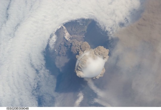
This is what an erupting volcano looks like from space.
📽: NASA Johnson
—
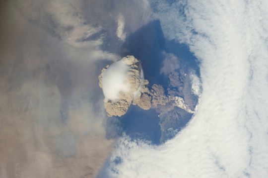
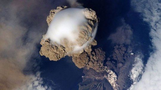
A fortuitous orbit of the International Space Station allowed the astronauts this striking view of Sarychev Volcano (Kuril Islands, northeast from Hokkaido in Japan to Kamchatka Peninsula in Russia) in an early stage of eruption on 12 June 2009.
Sarychev Peak is one of the most active volcanoes in the Kuril Island chain, and it is located on the northwestern end of Matua Island.
Prior to June 12, the last explosive eruption occurred in 1989, with eruptions in 1986, 1976, 1954, and 1946 also producing lava flows.
Ash from the multi-day eruption has been detected 2,407 kilometers east-southeast and 926 kilometers west-northwest of the volcano.
Commercial airline flights are being diverted away from the region to minimize the danger of engine failures from ash intake.
This detailed astronaut photograph is exciting to volcanologists because it captures several phenomena that occur during the earliest stages of an explosive volcanic eruption.
The main column is one of a series of plumes that rose above Matua Island on June 12.
The plume appears to be a combination of brown ash and white steam. The vigorously rising plume gives the steam a bubble-like appearance.
In contrast, the smooth white cloud on top may be water condensation that resulted from rapid rising and cooling of the air mass above the ash column.
This cloud, which meteorologists call a pileus cloud, is probably a transient feature: the eruption plume is starting to punch through.
The structure also indicates that little to no shearing wind was present at the time to disrupt the plume.
(Satellite images acquired 2-3 days after the start of activity illustrate the effect of shearing winds on the spread of the ash plumes across the Pacific Ocean.)
By contrast, a cloud of denser, gray ash — probably a pyroclastic flow — appears to be hugging the ground, descending from the volcano summit.
The rising eruption plume casts a shadow to the northwest of the island.
Brown ash at a lower altitude of the atmosphere spreads out above the ground at image lower left.
Low-level stratus clouds approach Matua Island from the east, wrapping around the lower slopes of the volcano.
Only about 1.5 kilometers of the coastline of Matua Island are visible beneath the clouds and ash.
Credit: NASA Earth Observatory
#volcano#space#NASA#International Space Station#Sarychev Volcano#Sarychev Peak#Matua Island#volcanologist#volcanology#volcanic eruption#meteorologist#pyroclastic flow#Kuril Islands#Japan#Russia
5 notes
·
View notes
Text
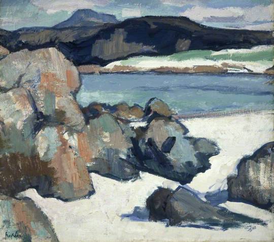


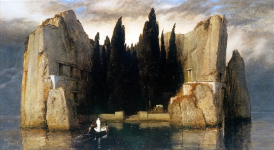

Something something island, something something seclusion and isolation.
Iona Landscapes: Rocks, Samuel John Peploe, 1927 // Pet Cheetah, Twenty One Pilots, 2018 // Sarychev Peak Eruption: Kuril Islands, NASA, 2009 // Afterglow, Taylor Swift, 2019 // Isle of the Dead: Third version, Arnold Böcklin, 1883 // ...Ready For It?, Taylor Swift, 2017
2 notes
·
View notes
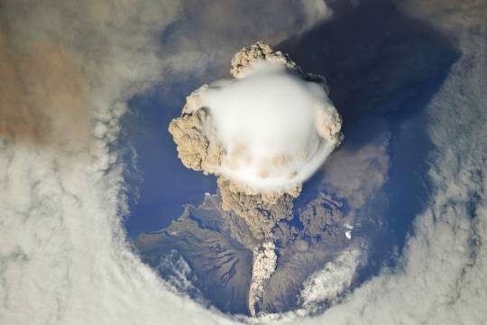
Photo
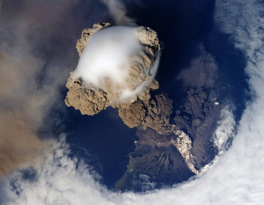
Sarychev Peak in the early stages of eruption in the Kuril Islands (Russia, June 12th, 2009). Photo taken from the International Space Station.
Sarychev Peak is located on the north-western end of Matua, an uninhabited volcanic island near the centre of the Kuril Islands chain north-east of Japan. The eruption sent a plume of brown-coloured ash and white steam rising into the atmosphere, and the plume was so intense that it cast a large shadow on the island.
Sarychev is one of the most active volcanoes in the Kuril Islands. Before June 2009, its most explosive eruption was in 1989; its eruptions in 1986, 1976, 1954 and 1946 also produced lava flows.
2 notes
·
View notes
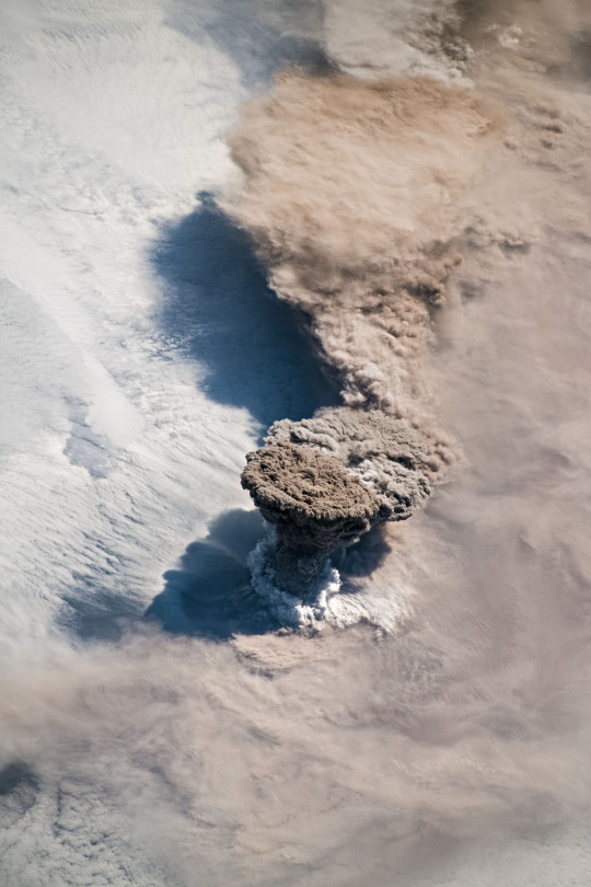
Photo
Aerial photo of Sarychev Peak erupting (Kuril Islands).
5 notes
·
View notes
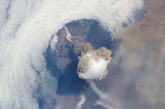
Photo
Matua Island, Kuril Islands, Russian Federation: Eruption of the Sarychev Peak Volcano and ash cloud photographed from space on 12 June 2009 by an astronaut orbiting Earth aboard the International Space Station. via /r/ScienceImages https://ift.tt/2ZyzfHb
0 notes
Photo
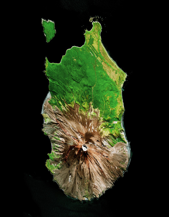
Sarychev Peak volcano, Matua Island
21 notes
·
View notes
Photo
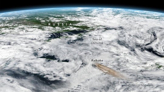
Raikoke Erupts
(https://earthobservatory.nasa.gov/images/145226/raikoke-erupts)
June 22, 2019
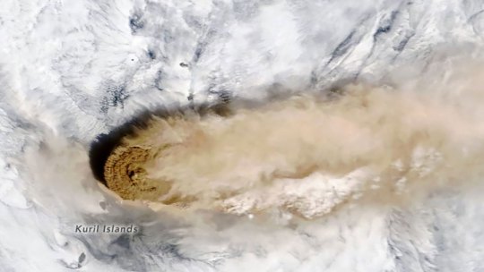
Unlike some of its perpetually active neighbors on the Kamchatka Peninsula, Raikoke Volcano on the Kuril Islands rarely erupts. The small, oval-shaped island most recently exploded in 1924 and in 1778.
The dormant period ended around 4:00 a.m. local time on June 22, 2019, when a vast plume of ash and volcanic gases shot up from its 700-meter-wide crater. Several satellites—as well as astronauts on the International Space Station—observed as a thick plume rose and then streamed east as it was pulled into the circulation of a storm in the North Pacific.
On the morning of June 22, astronauts shot a photograph (above) of the volcanic plume rising in a narrow column and then spreading out in a part of the plume known as the umbrella region. That is the area where the density of the plume and the surrounding air equalize and the plume stops rising. The ring of clouds at the base of the column appears to be water vapor.
“What a spectacular image. It reminds me of the classic Sarychev Peak astronaut photograph of an eruption in the Kuriles from about ten years ago,” said Simon Carn, a volcanologist at Michigan Tech. “The ring of white puffy clouds at the base of the column might be a sign of ambient air being drawn into the column and the condensation of water vapor. Or it could be a rising plume from interaction between magma and seawater because Raikoke is a small island and flows likely entered the water.”
3 notes
·
View notes
Photo
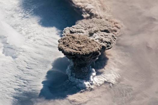
On the 12th of June, 2009, Sarychev Peak on Matua Island in the Kuril chain erupted and was captured by the International Space Station as it flew overhead..
This awesome image reveals some cool details about the eruption.
As you can clearly see, the volcanic plume extends high into the sky. If you look closer, you will note the atmospheric shockwave of the eruption; pushing the clouds back causing a ring shape to develop. Also visible is a smooth, fluffy white cloud on top of the rapidly rising ash column, likely the result of rapidly rising water vapour condensing on top of the plume.
-Jean
Image courtesy of NASA’s Earth Observatory.
#sarychev#volcano#eruption#volcanomonday#kuril islands#iss#space station#shockwave#ash#cloud#nasa#earth from space#the earth story
284 notes
·
View notes
Text
These Incredible NASA Photos Show a Volcano Erupting From Space
Earlier this year, astronauts in the International Space Station got a front row seat for an epic event, but it wasn’t happening in space. On June 22, the astronauts looked down at the earth and saw the Raikoke Volcano erupting, which led to some incredible images captured by NASA and other satellites.
7 Incredible Photos of the National Parks From SpaceIt was very rare sight—the Raikoke Volcano most recently erupted back in 1924, according to the National Museum of Natural History. Before the 1924 event, the volcano hadn’t had a recorded eruption since 1778. The volcano is located on an uninhabited island in the middle of the Kuril Islands chain between Japan and mainland Russia, and it reaches 1,808 feet at its highest point.
]]
An unexpected series of blasts from the remote #Raikoke volcano in the Kuril Islands sent ash and volcanic gases streaming high over the North Pacific Ocean. https://t.co/ptL4i4dNOH #NASA pic.twitter.com/XAUziKxurK
— NASA Earth (@NASAEarth) June 24, 2019
The volcano has a 700-meter-wide crater and the explosion created a large plume of ash and gas that reached between 13 kilometers (8 miles) and 17 kilometers (10 miles) into the sky, according to NASA’s report on the eruption.
The Top 10 Stargazing Sites in the World“What a spectacular image. It reminds me of the classic Sarychev Peak astronaut photograph of an eruption in the Kuriles from about ten years ago,” said Simon Carn, a volcanologist at Michigan Tech, in a NASA statement about the volcanic eruption. “The ring of white puffy clouds at the base of the column might be a sign of ambient air being drawn into the column and the condensation of water vapor. Or it could be a rising plume from interaction between magma and seawater because Raikoke is a small island and flows likely entered the water.”
The International Space Station (ISS) captured the Sarychev Peak Eruption in the Kuril Islands, Japan in 2014. NASA/Shutterstock
]]
Here are a few more of the incredible photos of the Raikoke eruption, courtesy of NASA:

]]
Courtesy of NASA / Earth Observatory EOS Project Science Office at NASA Goddard Space Flight Center / NASA
Courtesy of NASA / Earth Observatory EOS Project Science Office at NASA Goddard Space Flight Center / NASA
The 9 Quietest and Darkest National Parks
Read the full article
0 notes
Text
NASA Captures Spectacular Images Of Raikoke Volcano Spewing Ash Into The Atmosphere After Huge Eruption
An astronaut aboard the International Space Station has captured a spectacular image of a volcano with a 2,300ft-wide crater spewing ash into the atmosphere after a powerful eruption.
The Raikoke Volcano—located on an island in the northwestern Pacific's Kuril archipelago—has been dormant for roughly a century. But this quiet period came to an abrupt end in the early morning of June 22, when Raikoke blew its top sending a vast ash plume up to 8 miles into the sky, according to the Volcanic Ash Advisories Center (VAAC).
In the picture, you can clearly see how the cloud rises up in a narrow column before coming to a stop when it meets air of similar density.
"What a spectacular image. It reminds me of the classic Sarychev Peak astronaut photograph of an eruption in the Kurils from about ten years ago," Simon Carn, a volcanologist at Michigan Tech, said in a NASA statement.
"The ring of white puffy clouds at the base of the column might be a sign of ambient air being drawn into the column and the condensation of water vapor," he said. "Or it could be a rising plume from interaction between magma and seawater because Raikoke is a small island and flows likely entered the water."
Much of the plume is now drifting eastwards over the Bering Sea and authorities are warning aircraft in the region to be careful of volcanic ash. This could pose a danger to aircraft because it contains small pieces of rock and volcanic glass.
Satellite data also indicates that the eruption has spewed out large quantities of gas, namely sulfur dioxide, which may have reached into the stratosphere—the second main layer of Earth's atmosphere which starts between 4.3 and 12 miles high depending on the location above the planet.
"Radiosonde data from the region suggest that the eruption cloud is mostly in the stratosphere," Can said. "The persistence of large sulfur dioxide amounts over the last two days also indicates stratospheric injection."
It is important to closely monitor ash plumes that reach the stratosphere because they have the capacity to stay in the atmosphere for much longer than those which stop at lower altitudes.
Read the full article
0 notes
Photo
Sarychev Peak is located on Matua Island in the Kuril Islands of Russia. When the volcano erupted June on 11, 2009, the expulsion of debris caused significant interruption with air traffic between east Asia and North America. The eruption was also so great that astronauts aboard the International Space Station were able to photograph the plumes of ash and smoke rising from its cone as the force of its shock waves dispersed all clouds out of the line of sight.
48.090798, 153.199718
Instagram: http://bit.ly/2ofxVF7
Source imagery: DigitalGlobe
248 notes
·
View notes
Text
What was the question?
What was the question?
I didn’t catch what the moron asked. Maybe she isn’t a moron.
Was it where has all the weather gone?
Maybe things are about to get back to normal at last?
I am not wishing bad stuff for anyone but to go most of summer with so few tornadoes….
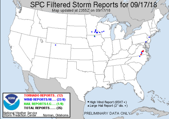
17 September 2018: Sarychev Peak, Nevado del Ruiz
View On WordPress
0 notes
Photo
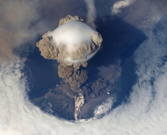
*A picture of Russia's Sarychev Volcano, on Matua Island in the Kuril Islands, erupting on 12 June 2009, as seen from the International Space Station (ISS). The ISS orbits the Earth at a height of between 347 and 360 km.
Original description by NASA: "A fortuitous orbit of the International Space Station allowed the astronauts this striking view of Sarychev volcano (Russia’s Kuril Islands, northeast of Japan) in an early stage of eruption on June 12, 2009. Sarychev Peak is one of the most active volcanoes in the Kuril Island chain and is located on the northwestern end of Matua Island.
Volcanic eruption from Space
840 comments*
“Interesting Fact: At 100m away from the site of a space shuttle launch, you would die of cardiac arrest. The pressure waves just from the sound of the rocket would cause your body to go into cardiac arrest as you'd physically feel the compression and expansion from the peaks and valleys of each wave. The resulting pressure would compress and expand your heart, like CPR from the fist of God. Explosions are fucking awesome.Edit: This is one of the ways being 100m from a shuttle launch would kill you. In no particular order, you would also be killed from the heat, the pressure wave (Shockwave), the flash, the steam, among others!”
0 notes
Text
‘What a spectacular image’: Here’s what an erupting volcano looks like from space
https://embed-prod.vemba.io/vemba-embed.js
The Raikoke volcano rarely ever erupts, but when it does, it goes big.
Astronauts and several satellites captured images of the volcanic eruption from space early Saturday morning. The plume from the eruption may have reached an altitude of 8 miles high, according to the Volcanic Ash Advisory Centers in Tokyo and Anchorage.
Raikoke is an uninhabited volcanic island in the northwest Pacific Ocean, off the coasts of Russia and Japan. The volcano is not nearly as active as many of its neighboring islands on the Kamchatka Peninsula.
The most recent Raikoke eruption was in 1924 and before that in 1778, according to a release from NASA’s Earth Observatory.
Volcanologists are keeping a close eye on a volcanic plume that reaches this high, as it can effect aviation and the climate.
The volcanic ash and gas rises in a narrow column and spreads out in the upper part of the plume in the shape of an umbrella, as seen in images taken by astronauts at the International Space Station.
“What a spectacular image,” Simon Carn, a volcanologist at Michigan Technological University, said in the NASA press release. “It reminds me of the classic Sarychev Peak astronaut photograph of an eruption in the Kuriles from about 10 years ago.”
According to NASA, the ring of clouds at the base of this column appear to be water vapor.
Volcanologists keep a close eye on plumes that reach this level of the stratosphere, as they can have a large effect on both aviation and climate.
from FOX 4 Kansas City WDAF-TV | News, Weather, Sports https://fox4kc.com/2019/06/26/what-a-spectacular-image-heres-what-an-erupting-volcano-looks-like-from-space/
from Kansas City Happenings https://kansascityhappenings.wordpress.com/2019/06/27/what-a-spectacular-image-heres-what-an-erupting-volcano-looks-like-from-space/
0 notes
Last Seen Blogs
multiplicityrpc
the eris system

vatyrie-avaris
Wayward Ranger, Demi-Devil Debonair

htrds
Untitled

subboijohn
Untitled

daddys-dumb-cow
🩷Toy/Cow🩷