#Roaring Fork Valley
Text
Great Room in Denver

Inspiration for a mid-sized, contemporary great room renovation with white walls, a stone fireplace, and a ribbon fireplace.
#mountain contemporary#roaring fork valley#regional modern#basalt#modern windows#colorado#modern duplex
0 notes
Text
Pretty.
0 notes
Photo

Guest - Modern Bedroom
Mid-sized minimalist guest bedroom with white walls and a light wood floor.
0 notes
Photo

Glass - Exterior
Example of a mid-sized trendy brown two-story glass exterior home design with a shed roof
0 notes
Photo

Patio in Denver
Mid-sized trendy side yard concrete paver patio photo with a fire pit
0 notes
Photo

Modern Bedroom
Image of a medium-sized, minimalist master bedroom in porcelain tile, featuring white walls, a regular fireplace, and a stone fireplace.
0 notes
Text
Leaving Colorado: The Time Has Come
Yes, After Twenty Years Living and Working, Here in The The Roaring Fork Valley, Kris and I are Pulling Up Stakes, and Moving On
Yes, After Twenty Years Living and Working, Here in The The Roaring Fork Valley, Kris and I are Pulling Up Stakes, and Moving On
And so, on May 1st, 2023, a full six years to the day on which we took posession of the place, we will hand over the keys to 111 Aspen Airport Business Center, Suite D, and head out on the open road
Introducing: THE KMJ Stoneworks Travelling Gallery
~ ~ ~
THE KMJ…
View On WordPress
#Colorado#KMJ Bus#Marble#Martin Cooney#Roaring Fork Valley#Sculpture#Stone Carving#Travelling Gallery#Woody Creek#Yule marble
0 notes
Link
happily i got to vote against her today
#the church where she spoke was of course center of one of the larger covid breakouts in the valley#leading to one death#out of only a handful in the roaring fork valley
2 notes
·
View notes
Photo

Bedroom Guest
#Bedroom - large transitional guest carpeted#gray floor and vaulted ceiling bedroom idea with gray walls roaring fork valley#kids bedroom#bedroom#mountain home#girls' bedroom
0 notes
Text

Rain Shower, Roaring Fork Valley, Colorado, Photo by James Baker
212 notes
·
View notes
Text
For those that are curious, this is the Real World Horizon location map that Count uses, done by jesuscuervo on Reddit.
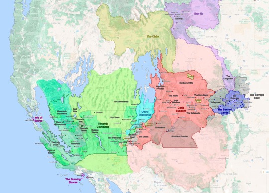
See under the cut for more information.
Real World Horizon Map (Speculative)
The Embrace proper is just the valleys and lakes between Pike’s Peak and Cheyenne Mountain, the core of the Nora Territory. Here, I placed each village in a valley respective to the location of Cheyenne Mountain but moved a few things around so it would not be too crowded.
The Outer Sacred Lands – outside the Embrace proper – contain several outcast camps. I had the Nora Territory expand across the Grand Mesa and Gunnison National Forest. Brom’s Camp is located over the Black Canyon of the Gunnison as it is depicted in-game, while Rost’s Hovel and Grata’s Camp are located on the hills/mountains closer to the Embrace.
Valleymeet; the neutral land between The Sacred Lands and the Carja Sundom is based on Maroon Bells, CO in-game. However, I mapped it out to include all of the White River National Forest within Valleymeet.
Hunter’s Gathering the main settlement in Valleymeet would likely be would be located on the Roaring Fork Valley near Woody Creek. That is the largest open valley in the area and the path through which the present-day CO-82 passes could work as a main throughway between the Nora and Carja lands.
Shivering Watch, following CO-82 the mountains narrow into a canyon south of Glenwood Springs (not Glenwood Canyon). The canyon acts as the chokepoint and border between the formerly Nora lands and the Carja Sundom where Shivering Watch and The Daytower are located.
Two Teeth Camp is depicted as being on Maroon Peak in-game. However, it is built over the ruins of the Smuggler-Union Hydroelectric Plant, which is further south in Telluride, CO. I kept Two-Teeth in the southern location so it acts as a second buffer between the Sacred Lands and the Sundom.
The Carja Sundom; is where the game took the greatest artistic liberty. The game depicts the heartland of the Carja Sundom south of the Colorado River (Lake Powell specifically); however the real-world locations depicted within The Sundom, the area its geography is based on (Eagle Canyon, Arches, and Canyonlands National Parks), and the route Alloy travels through suggests the Sundom is actually located north of the Colorado River in the real world. Thus rather than having the Sundom’s heartland located in the Colorado Mesa, it would make more sense to place it in the already fertile Price and Green River Valleys in Utah. This way I was able to keep Meridian in Eagle Canyon and Sunfall in Bryce Canyon. Thus Sunfall is actually southwest rather than northwest of Meridian. The Carja Sundom would extend across most of the Western Slope in Colorado into most of eastern and southern Utah. With Shatter Kiln (Provo) as its northernmost boundary.
The Sun-Steps – are the first region of the Sundom that Alloy encounters on her journey. In-game it stretches from Arches National Park to what appears to be Horseshoe Bend. However, Horseshoe Bend is too far south for it to make sense as the border, so I have Morning Watch located further north on another bend. Since river bends can form anywhere it is not a stretch to think there is a new bend somewhere else. Over all the Sun-Steps correspond to the Grand Valley in CO.
Free Heap – located within the Sun Steps is Free Heap, an Oseram outpost set up to provide construction material for Meridian. If they are mining for industrial materials from the Old Ones, it would make the most sense for Free Heap to be located on or near Grand Junction CO, which is the largest settlement in the area today.
Gatelands – form the eastern half of the central Carja Sundom. Unlike the rest of the Sundom, this region is relatively easy to map out since most locations have an obvious real-world reference corresponding to Arches and Canyonlands National Parks.
Lone Light had to be relocated since Horseshoe Bend is much further downriver in reality. I placed it in a smaller bend upriver.
Gatelands Bandit Camp - I depicted the Bandint Camps as neutral/independent enclaves within the Sundom, the Gatelands Camp being the largest one of these and corresponding to the entirety of Arches National Park.
The Jewel – the central heartland of the Carja Sundom appears to be based on Monument Valley in present-day Utah and Arizona. However this location would be rather out of the way from Aloy’s journey and it doesn’t fit some of the locations depicted within the Jewel itself (mainly Meridian, which is located in Eagle Canyon). Thus, I thought it made more sense for it to be centered on the eastern Green River Basin along the present-day Carbon, Emery, and Wayne counties. This way Meridian remains in Eagle Canyon and the Spurflints in the San Rafael Reef. The Spearshafts would be a new formation (not present today) somewhere in Canyonlands National Park.
Rustwatch – in-game the Shadow Carja territory is north of the Jewel across from Daybrink (Lake Powell), however since The Jewel is no longer located south of the Lake, Rustwatch and Sunfall are now southeast of the Carja heartland. But Sunfall keeps its location in Bryce Canyon.
The Southern Frontier – in-game Kestrel’s Perch is defined as a fortress built by the fifth Sun King Zavarad as the Sundom expanded north of Daybrink (Lake Powell) into Rustwatch. However because in the real world, Lake Powell is south of what I’ve defined as the Carja heartland, this frontier is now south of Daybrink and Rustwatch.
The Mountain Frontier – Call of the Mountain doesn’t really give many references on where Rising Light and the main route of the game are located, except that it is mountainous and – for the most part – densely wooded. So I opted for the Sundom to have a “Mountain Frontier” along the Wasatch Range. Because the world of Horizon is likely set in a warmer and wetter Earth (due to rising sea levels), the Bonneville and Lahontan Great Lakes have been resurrected east of this range. The former of these acts as The Sundom’s western border and provides the precipitation and rainfall necessary to create forests and jungles in the Colorado Plateau.
Shattered Kiln – a bandit camp near the northern reaches of the Sundom, as in-game it is based on Provo Utah near Maker’s End (Salt Lake City).
The Daunt; the southwestern corner of the Carja Sundom corresponds to Zion National Park. However, Zion is relatively small to fit all the in-game locations. In-game, Zion National Park appears to be the same size as the entirety of Southern Nevada or the California Central Valley. To fit everything in, I extended The Daunt to include the entire Virgin River Basin in Washington County Utah.
Barren Light would then be located with St George, Utah where the Virgin River (and the I-15) cross Bloomington Hills.
Chainscrape and the Redhew Quarry, the Oseram settlement within the Daunt is located along a bit upriver from Barren Light.
The Claim; the Oseram territory is not depicted in-game, however, Pitch Cliff and Free Heap are two Oseram settlements near their border with the Carja Sundom. It is stated that their territory is north of The Sundom and west of The Cut, so it likely corresponds to Idaho, specifically the Snake River Basin.
Pitch Cliff is likely located along the Roan Cliffs, and possibly very near the border between the Claim and the Sundom.
The lands between The Long Roam, the Claim, and the Carja Sundom form an unclaimed region around the present-day Uintah Basin. Oseram traders travel through it and the Carja might have sent some raiders across it, but it remains mostly unpopulated. I shaded this area pink as the Carja might claim it but likely hold no direct control.
No Man’s Land - is the border between the Carja Sundom and the Tenakth Clanlands. No Man’s Land borders are not well defined in-game, but they seem to correspond to the northern shore of Lake Mead, specifically the area around the Overton Arm where the Virgin River meets the Lake. The overall location works for a real-world equivalent, but a few things get shuffled around for them to fit.
Jagged Deep; the eastern bank of the Virgin River was tenuously controlled by the Carja Sundom. What remains is Riverwatch, an abandoned fort on the banks of the Overton Arm, and Jagged Deep an abandoned mine that is now delved by Oseram adventurers. The Carja Camp on the west bank of the Overton Arm is the furthest west Carja settlement.
Eastern Lie & Deadfalls are the westernmost Tenakth settlements closest to the Cajra and Utaru borders, which have been taken by Regalla’s Rebels. In fact, most of the Tenakth side of No Man’s Land is occupied by the rebels.
Spinebreak; in-game Spinebreak is located on the southeastern border between No-Man’s Land and the Tenakth Clanlands proper and built under the ruins of a present-day highway tunnel. The issue is that there are no tunnels – or logical places to put a tunnel – between the Overton Arm and Las Vegas (the Stillsands). I thus place Spinebreak further north on the Virgin River Canyon acting as a second border between Barren Light and the Tenakth camps.
The Utaru Tribal Lands; the Utaru settled in the lands surrounding the Western Grand Array (WGA), which they named Plainsong.
Plainsong, although the WGA is based on the Very Large Array in New Mexico, the VLA is very far from Aloy’s path and the in-game geography. Furthermore just like the Nora take their name from the NORAD Facility and the Tenakth take their name from the Tenth Task Force, I suspect the Utaru take their name from Utah. Thus it is likely that the WGA is not the VLA but rather a new array built somewhere in Southern Utah, between the Carja Sundom and the Desert Clans. With this in mind, I placed Plainsong on the Cedar Valley and worked from there.
Stone’s Echo – Stone’s Echo is an Utaru outpost near the Stillsands, just past No Man’s Land. I placed it along the Meadow Valley Wash, which would likely be a tad more fertile than in the present day. Because we are dealing with what I expect is a warmer and wetter climate due to rising sea levels (and AETHER’s supercell storms going haywire).
Riverhymn – On the northern edge of the Utaru lands lies Riverhymn; the second largest Utaru settlement after Plainsong. In-game it is located in a fairly mountainous corner. So it is likely located near Frisco Peak with the river that passes through it being the Beaver River. However this river flows in the opposite direction that is seen in-game, rather than flowing south towards Plainsong, it flows north into the Sevier Lake.
·Due to the wetter climate, it is possible that the entire Bonneville Basin is once again flooded and Lake Bonneville acts as a boundary between the Utaru, the Carja, the Oseram, and Tenakth Desert Clans but the game map does not go that far north. Regardless I thought it be cool so I opted to depict it as such.
Tenakth Desert Clans; the Desert Clans inhabit most of Southern Nevada. Their territory reaches the present-day Great Basin National Park in the northeast and the Shining Wastes (Death Valley National Park) to the West.
The Stillsands; southwest of the Utaru territory, is another semi-contested region (it is within the Tenakth Desert Clan territory but both major settlement Camp Nowhere and Hidden Ember are Oseram). This is pretty simple since it corresponds to Clark County NV, with Hidden Ember clearly being Las Vegas. I originally had Devil’s Grasp be located in Barstow CA, but opted to place it closer to Las Vegas in Primm.
Dry Yearn; is the easternmost region of the Clanlands. It contains Arrowhand, the second largest Desert Clan settlement, and Restless Weald. It is fairly easy to place since Restless Weald is based in Caliente, NV. With this in mind, I placed Arrowhand over Crystal Springs, NV, and the Dry Yearn Camp just north of Restless Weald.
The Greenswell; is the northernmost region of the Desert Clanlands; it is also the least arid region of the Desert Clans. Part of this can be attributed to the supercell storms, but I also opted to have the core of the territory within the Great Basin National Park, which is a very green area within the Nevada desert, which further explains the area’s climate.
Scalding Spear; centrally located in the Nevada desert, the capital of the Desert Clans is located on the present-day Crescent Dunes Solar Energy Project.
Shining Wastes; is an arid mostly flat expanse of land, which for the most part corresponds to Death Valley National Park. The only problem is that Death Valley is not particularly flat. I included Death Valley, now filled in with a saline lake, within the Shining Wastes but placed the main settlements located further north within the Nevada Desert (which is mostly flat).
Runner’s Wild – a small region in the Desert Clan territory, Runner’s Wild corresponds to Mammoth Lakes in California and acts as a border between the Desert and Sky Clans.
Salt Bite – north of Runner’s Wild this region borders Runner’s Wild and the Greenswell, it is clearly based on Mono Lake in California and the geography easily fits into this location.
Memorial Grove; although the Tenakth are divided into three warring Clans (and Regalla’s Rebels), the Memorial Grove acts as a capital / neutral ground for all three. The Grove is located on a museum and military base – specifically an airforce base – south of Mono Lake. The base does not exist in the present day but could be located anywhere in the Owens Valley. I paced it on Independence, CA (fitting name). Like other areas on the map, the Owens Valley is also much more fertile than in the current day.
Tenakth Sky Clans; northwest of the Memorial Grove the Sky Clans make their home along the Sierra Nevada, specifically Yosemite Valley and the Sierra National Forrest. Not many changes here, but it doesn’t seem like their territory expands much further north than Lake Tahoe (unless it is not depicted).
The Bulwark; the capital of the Skyclans is based on Sentinel Dome in Yosemite Valley, I kept it here and based the rest around it.
Sheerside Mountains; are based on the Sierra Nevada, the region itself corresponds to the northern half of the Sky Clans’ territory. I took Sheerside Climb to be the pass from Mammoth Lakes to Yosemite and assumed Bonewhite Tear and the other settlements would be located along CA Route 120 and the Tuolumne River.
Stand of the Sentinels the southern region of the Sky Clans appears to be based off the Sierra National Forest. Its major settlements follow a pass from Mammoth Lakes to Tide’s Reach (possibly Fresno CA, see below). This suggests that the major settlements are located along the San Joaquin River.
Tenakth Lowland Clans; like the Carja Sundom, the Lowland Clans pose a huge conundrum. The Lowlands seem to consist of the foothills of the Sierras along Kings Canyon National Park and the Sequoia National Forrest towards a coast. This suggests that California’s Central Valley is flooded due to rising sea levels. If this is the case it helps explain why The Long Coast (Bakersfield) is a coast and not inland.However, if this were the case there should be a long peninsula formed from California's Coastal Ranges. But this peninsula is completely absent from the in-game map. Furthermore, Tide’s Reach appears to be based in Oakland, but it is geographically located at the foothills of the Sierra National Forrest. This should be impossible; Oakland would be located on the aforementioned “peninsula” between San Francisco Bay and the “Central Valley Sea”, but this peninsula is nowhere to be found on the map.
I tried my best to come up with a creative solution.
Raintrace – as in-game Raintrace is based on Sequoia National Forrest, Lowland Path and Fall’s Edge are located along CA Route 180 and King’s Canyon, which provide a direct route from the Memorial Grove to the rest of the Lowland Clans’ territory. Fenrise is further south on Isabella Lake where the Kern River valley provides a connection between the Desert Clans and Lowland Clans’ territories.
Tide Reach – I relocated Tide’s Reach to Fresno, CA which is now along the coast of the “Central Valley Sea”. I opted to have it based on Fresno since it provides another large present-day settlement where to base it, and more importantly, it is directly on the path Alloy would take from Stand of the Sentinels. Since Alloy can’t swim from Tide’s Reach to the Isle of Spires (San Francisco) it makes sense to place it further away from the island than Oakland. SF Bay is large, but not large enough for there to be a storm that wrecks Alloy’s raft. To make the route Alloy takes a bit more logical I also broke up the Coastal Ranges north of the Salinas River into an archipelago. I considered sinking the entirety of the Mt Diablo Range, to provide a direct route from Tide’s Reach to the Island, but I thought that would be too much.
The Long Coast – in-game The Long Coast seems to refer to the Pacific Coast, but as already mentioned it also refers to the ruins of Bakersfield CA. Thankfully a flooded Central Valley means we’ve gained a new coast. Thus the Long Coast now refers to the western coast of this inland sea. Thornmash, in-game coordinates suggest it is located near Tracy, CA. but I placed it a little further south on this coast so it forms a triangle with Tide’s Rach and Raintrace Rise and so it is not too close to San Francisco.
Cliffs of the Cry – as in-game the Cliffs correspond to Big Sur and the California Pacific Coast. I opted to have Raintrace West located on the Cliffs (close to San Luis Obispo) since you travel from it to the Zennith Base.
Isle of Spires; is straightforward San Francisco, which is now an island. Alva describes San Francisco as an archipelago, so this helped me further justify the breakup of the Coastal Ranges. Although I realize that such geologic shifts would likely destroy the city of San Francisco itself. This is the suspension of disbelief in a world that has a volcano appear on Yellowstone and New Zealand sink beneath the waves.
Zenith Base; originally I thought about having it located in Monterey however it is south of Tilda’s Mansion, which is in Big Sur. It then seemed fitting to place the Zenith Base in Vandenberg Airforce Base instead.
The Burning Shores; it is LA, which like San Francisco is now an archipelago due to tectonic activity and rising sea levels. This is pretty much explained in-game.
Fleet’s End is located somewhere in the Baldwin Hills, which are now the main island of the “bay”
Pangea Park / Londra Productions is described as being on a peninsula. Because it is partially based on Dinseyland (or Universal Studios) I’ve opted to keep it in Anaheim. To make Anaheim a peninsula I’ve flooded the San Gabriel Valley in the north and Newport Beach in the south.
#aloy and seyka#aloy x seyka#horizon burning shores#horizon forbidden west#countdown#my writing#countdownfic#horizoncountdown#field guide
27 notes
·
View notes
Text

Devin's Dude Ranch: Episode Four
*the episode opens with a shot of Echo Valley Ranch. the sun sits low in the graying sky and the trees cast their long shadows across the ground.*

Devin, in diary room: "Tonight is our first group date and I'm so excited to get to spend more quality to time with the guys! I mean, I've missed them! Is that weird?" *lets out an unintentional snort laugh* "I know I just saw them all yesterday for the nectar making contest, but it's not like we actually got a chance to talk or bond or anything. So, yeah. I'm looking forward to tonight."

*next shot shows the contestants lined up in front of Devin. They are standing in the backyard of the house.*
Devin: "Hi guys! I hope you're all excited as I am about tonight because it's our first group date!"
*the contestants whoop in reply which makes Devin grin and blush slightly*
Devin (continues): "I know it's a little chilly out, but I have just the thing to keep us warm..."
Devin: "A weenie roast!"
*enthusiastic murmuring spreads among the contestants*
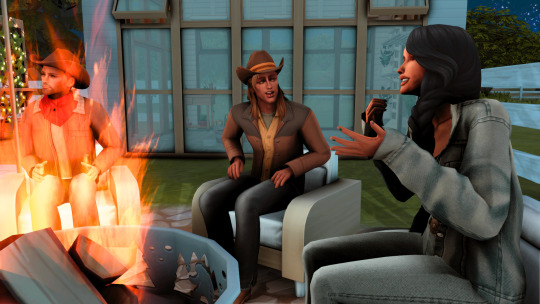
Devin: "Alright, why don't we head over to the fire pit and get comfortable?"
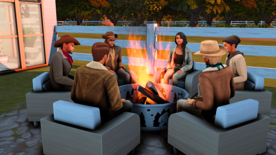
*everyone chooses a seat around an already roaring fire and looks to Devin expectantly. there's a beat of uncomfortable silence that follows.*
Devin: "So...you'll all have to forgive me if I'm a bit awkward. This is my first time going on a date with five dudes at the same time."
*chuckles ripple throughout the group*
Devin (continues): "There are dinner kits next to everyone's chairs if you're hungry. Otherwise, I thought we could just talk. Get to know each other better. To get things going I thought we could go around and all share something fun about ourselves. How about what's the silliest thing you've ever searched on the internet?"
*the group laughs again*
Stan: "Only if you go first, missy."
*more laughter, with Devin joining in*
Devin: "Alright, fair enough."
*she pauses a moment to consider her answer while the group looks on*
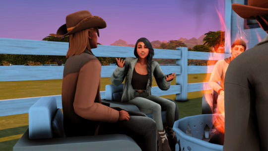
Devin: *chokes on a laugh* "Oh my Watcher. I can't believe I'm about to admit this to you guys. Okay. So, my cousin, Lacey, got me an AirTag because, and you should all know this about me, I am infamous for losing my keys. Well, needless to say, I lost 'em. But for the life of me, I couldn't remember exactly how she said the AirTag worked, so I pulled out my phone and searched," *pauses, covers her mouth with her hand, and squeezes her eyes shut* "Find my keys."
*the group howls with laughter*
Devin: "I know! I know! It was so dumb! But cut me some slack, okay? I'm not the most technically savvy!"
*as the laughter subsides, she turns to Houston*
Devin: "Your turn, cowboy."
Houston: "Hmmm....," *settles back in his seat and thinks for a few beats*

Houston (continues): "Alright. This one seems silly now, in hindsight. But, it was really late at night and I hadn't had much sleep and I had been writing for almost ten hours straight. But, I searched," *pauses briefly and smiles to himself*, "Does grammatical phrasing and ending dictate the relationship between syntax and the poetic line?"
*the group is so quiet the only sound are the crickets singing in the background*
Milo: "I don't get it."
*Devin looks slightly confused*
Houston: "Well, you see..."
Stan: "Don't even try, man. We're all too dumb to understand."
*the group breaks out into laughter again*

Handra: "I'll go next."
Devin: "Awesome. Let's hear it!"
Handra: "I'm kinda ashamed to admit, but this is something I have searched for on more than one occasion," *surprised hissing emanates from the people around him* "Yeah, I know. But, I can never remember which one is the damn salad fork."
*Handra laughs nervously*
Albert: "Wait, didn't you also work in a restaurant?"
*Handra's head droops*
Handra: "Yes."
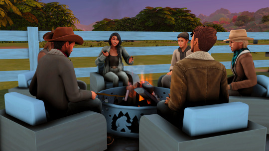
Devin: "Well, I don't think you'll have to worry about that around here. My philosophy is one fork for everything."
Houston: "Who has time for all those extra dishes, am I right?"
*Devin glances over and grins at Houston*
Devin: "Nail. Head."
*the two share a moment of eye contact before Stan clears his throat*

Stan: "Well, mine was an almost search. I started to type it in and thought it was too stupid and stopped myself."
Albert: "Oh, I gotta hear this."
*Devin looks to Albert*
Devin: "*Bleep*, me too."
*Stan grins and chuckles to himself*
Stan: "As I'm sure y'all have figured out by now, I'm very fond of my coffee. Well, one day I almost searched caffeine overdose. Isn't that ridiculous? Can you imagine?"
*Devin glances around the group with a worried expression*
Devin: "Umm...Stan. Caffeine overdose is a real thing. I mean, it's not super common, but it even kills people."
*Stan's face falls*
Stan: "What?"
*His eyes search the faces of the other contestants who are nodding to him in confirmation*
Stan: "Well, *bleep*."
*Houston reaches over and pats Stan on his shoulder*
Houston: "Sorry, buddy."

Milo: "I guess I'll go, " *he sighs and leans forward, resting his arm on his leg*, "I don't have the best memory. Probably because I've been hit in the head too many times. But, to make a long story short, I couldn't member my Mom's phone number so i had to search it after I got a new phone," *buries his face in his hand and laughs* "Which is really, really sad."
*the group laughs meekly, almost as if unsure if they should or just feel sorry for him*

Devin: "Awww! I'm not going to lie. I've been there. I mean, not with family. but with someone else I probably should have known their number."
Milo: "Thanks, Devin. At least I know I'm not alone."
*Devin winks across the fire at Milo*
Devin: "You're up, Albert."
Albert: "Can you milk cowplants?"
*the group sits in stunned silence for a moment, processing what Albert just said*
Albert (continues): "That was my search. And I already know what you ranchers are going to say," *holds up his hand to use a puppet and takes his voice up an octave* "Of course cowplants don't product milk, Albert. They're not actually cows. They're aliens," *his voice shifts back to normal* "Thank you, everyone. I found that out when I searched."
*Albert laughs and plants his face in the palm of his hand*
*the group bursts out into laughter, everyone except Stan*
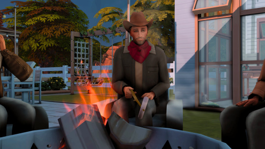
*Stan has Albert locked in a steely stare, the hot dog he's been roasting now turning black in the open flame*
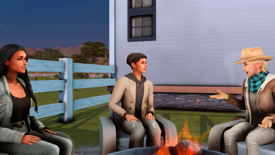
*indistinct conversation and laughter can be heard as a low buzz begins to fade in*
*conversations fade out as the buzz grows louder*

*Stan's glare begins shifting to each of the men around the fire*

Stan, in diary room: "I don't know what happened. I was just sitting there, and suddenly a wave of...intense jealousy came over me. Getting Devin's attention in this pack of wolves feels *bleep*ing impossible. This is going to be so much harder than I thought."

*the camera cuts back to the campfire. everyone is locked in their own conversations.*

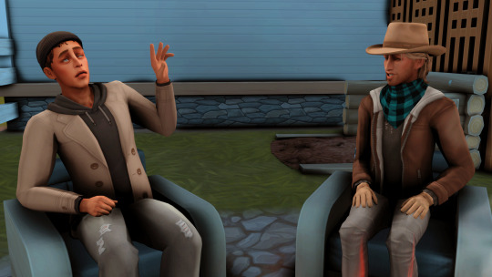
Houston: "You know, I'm not exactly a fan of technology, either."
Devin: "Oh yeah?"
*Houston nods solemnly*
Houston: "Since the war."

*Devin's face softens*
Devin: "It's okay if you don't want to talk about it."
Houston: "No. It's okay. I want you to know."
*she nods and leans closer*
Houston: "It's just, that I've seen what we've made technology into. What it's capable of. The horrors it can inflict. I guess, it's made me not trust it."
Devin: "I don't think anyone can fault you for that. Least of all me."
*the two lock eyes and share a moment of comfortable silence*

*after an obvious time lapse, the next shot is focused on Devin*
Devin: "Guys, this has been a lot fun but unfortunately, it's time to call it a night. I hope you had as much fun as I did."
*everyone gets to their feet, hug Devin, and begin making their way into the house*
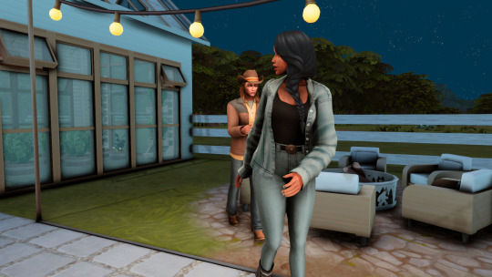
*Devin begins to head inside when Houston hurries behind her*
Houston: "Devin! Wait!"
*Devin glances over her shoulder before stopping in her tracks and turning to wait for Houston to catch up*

Houston: "This is probably against the rules or whatever, but I don't care."
*he reaches out, takes her hand, and pulls her gently against him.*
*Devin smiles in surprise*

Houston (continues): "I've been dying to do this and I couldn't wait any longer."
*Houston wraps his arm around Devin's waist and as she drapes hers across his shoulder. their faces are inches apart*

Devin: "So do it, already."
*she now cradles his face, her eyes burning into his*
*Houston smiles down at her*

*after a beat Houston leans forward, eagerly kissing Devin for the first time.*
*she meets his lips with a soft moan*
*Houston gently tightens his grip on her*

Houston, in diary room: "A gentleman doesn't kiss and tell. But, suffice to say, this is one of my most magical nights of my life."


Devin, in diary room: "He kissed me. He *bleep*ing kissed me." *swoons*
PREVIOUS | NEXT
Houston submitted by @invisiblequeen
James "Stan" submitted by @natolesims
Albert submitted by @bakersimmer
Milo submitted by @belsasim
Handra submitted by @bloomingkyras
#devinsduderanch#devin delaney#houston bloom#handra diaz#albert robins#james stanford#milo penn#sims 4 bachelorette#sims 4 bachelorette challenge#echo valley ranch#chestnut ridge#sims 4 horse ranch#simblr#the sims 4#sims community#ts4#sims 4 love story#sims 4 story#sims 4 screenshots
21 notes
·
View notes
Text
3 World-Class Hiking Destinations Not to Miss
What sets one hiking destination apart from another? Is it the trail experience? The journey into the unknown? The landscapes? The views? For the hiking enthusiasts out there, it can easily be “all of the above” and more. A memorable hike can be a defining experience on a very personal level.

There are incredible hiking destinations all around the world. You can find them on every continent. Of course, it’s hard to deny the sheer number of breathtaking hiking opportunities across the United States. There are three destinations, in particular, where you can find luxury home rentals and exceptional hiking for a world-class experience all around.
Vail Valley, Colorado
Throughout Colorado, you’ll find countless opportunities to “get lost” in the Rocky Mountains. Vail Valley, which includes premier destination locales like Vail and Beaver Creek, can bring you face-to-face with many of those opportunities. If you’re an outdoor enthusiast, Vail and Beaver Creek can be a true gem.
From golfing to hiking to river rafting, there’s something for everyone. On top of that, you’re surrounded by some of the most stunning peaks in the Colorado Rockies like Grand Traverse Peak, Mt. Powell, and so many others. Some days, all you might want to do is kick back and take it all in.
Aspen, Colorado
Near the heart of the Rocky Mountains, you’ll find the town of Aspen. Aspen is full of amenities and experiences all its own. However, if you want to experience the great outdoors—and the Rocky Mountains—a short journey outside the town can open up all kinds of possibilities.
Starting from Aspen’s luxury villa vacation rentals, you can discover trails along the Roaring Fork River or make your way up from the valley and into the mountains. There are dozens of trails within minutes from Aspen. Some trails are ideal for casual hikers, while others are more suited for seasoned hikers. There are hiking experiences for everyone in Aspen.
Big Island, Hawaii
In the middle of the Pacific Ocean, you can find hiking experiences unlike anything else in the world. These are the kinds of hiking experiences that can take you from dense jungle one moment to breathtaking views of the water the next. You can hike along trails hidden away in narrow valleys and along trails high in the mountains, surrounded by waterfalls and mist.
In other words, if you are seeking a diverse and rewarding hiking experience, Hawaii can easily deliver. Like the Vail Valley and Aspen areas, you can find trails for all skill levels. If you want something more relaxed, you can find it. If you want something more intense, you can find that, too.
More than that, Hawaii is a diverse destination for adventurers and thrillseekers alike. From stargazing to snorkeling to surfing, there’s something for everyone. But it’s hard to deny just how incredible the hiking experiences on the Big Island can be.
About Cuvée
With Cuvée, you can have a bespoke experience in every one of their luxury house rentals. From their thoughtfully curated properties hidden away in the majestic Colorado Rockies to their grand island oases in the sapphire waters of the Caribbean, every Cuvée residence is tailored to your needs. Cuvée’s dedication to your needs and desires goes beyond their luxury accommodations. It also extends to every experience at every Cuvée destination. Through Cuvée’s team of Experience Curators, you and your loved ones can become immersed in the grandeur of the Colorado Rockies with hiking, fishing, horseback riding, fine dining, and much more. Every Cuvée locale is home to a world of new experiences waiting for you.
Discover these world-class hiking destinations for yourself at https://www.cuvee.com/
Original Source: https://bit.ly/3yM45SF
0 notes
Text
do you know that “i love you” before we even meet?
And this is how i am searching by writing in the depths of thought
(to first cross paths)
this is the direction i chose to take when coming across a fork in the road (even to be challenged by fear but overcoming it by standing up for my “seed”)
have you ever been to the Roaring Fork Valley (named after the river there) in the Rocky Mountains of Colorado?
i’ve passed through a few times, stopped for a few good cups of coffee and to write a few lines
maybe you will read and come to think (to “see”) the same as i?
0 notes
Text
Gabe Matherly | A Versatile Business Professional
Gabe Matherly is a highly ethical and loyal individual with an open mind and a great sense of humor. He is a trusted and easy-going individual with a wide-ranging background and experience. Born in Aspen and raised in the Roaring Fork Valley, Gabe Matherly graduated from Basalt High School before pursuing a bachelor's degree at the University of Hawaii, Hilo. Gabe Matherly's love for traveling has taken him to several countries such as South Africa, France, Great Britain, Guam, Saipan, American Samoa, and Mexico. He enjoys exploring new places and cultures. Gabe Matherly was recognized by the state of Colorado for developing his agency's Operational handbook, which serves as a model for other non-profit organizations. Gabe Matherly is a versatile business professional who currently serves as the Director of Operations for Community Health Initiatives, Inc. Gabe Matherly has also been awarded "Best Theater" and "Best Family Entertainment Venue" for Kress Cinemas in Hilo during his time there.
0 notes
Last Seen Blogs

furyvschisora
Fury vs Chisora Live Stream Free

pinkcouture
NZ Daddy

hmccrory
Haveyoueaten

new-albany-law
McNeely Stephenson Law Firm

nikonik
Пишу о футболе