
weathermadness
Weather Madness Blog
Weather Madness is the blog that looks at the madness of weather.
1316 posts
Don't wanna be here? Send us removal request.
Last Seen Blogs

the-art-crow-blog
Yes i changed this to Sailor Moon also

proudly-below-average
To Die Would Be An Awfully Big Adventure

easy-society
Без названия

bts-fantasy
Bangtan? Ddaeng

edimexon
Edim Exon
Photo

Very volatile day in Plains as numerous tornadoes are expected, some large and long-tracked. There is the potential for significant damage to towns in the path of any of these tornadoes. Make sure to have your family safety plan ready this afternoon!
0 notes
Photo

The weather map this morning shows low pressure over the Plains which will produce severe storms ahead of the cold front. The second storm coming through the West will bring more severe storms to the Plains this weekend. Warmer weather will move into the East Sunday!
0 notes
Photo
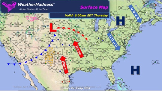
The surface map this morning shows low pressure coming into the Plains. This is the first in a series of storms that will bring severe to the Plains the next 4 days. The first round of tornadoes and damaging hail my snuggle-up near the low center in western Kansas today.
0 notes
Photo

The surface map this morning is showing a cold front that will bring colder weather. Some snow will fall across the northern part of the Northeast today. Frost and freezes will be widespread from the Great Lakes into the Appalachians and Northeast tonight.
0 notes
Photo

This mornings weather map shows a cold front coming through the Great Lakes. That front will bring more cold weather and the potential for Frost and Freezes Wednesday through Friday Mornings. The Northeast will see some snow Wednesday!
0 notes
Text
Weekly Highlights for April 15 to 21 - Severe Storms this Week
This is going to be a busy week of severe weather starting Sunday and lasting through Wednesday, perhaps into Thursday. The first rounds will hit Sunday and Monday as a cold front comes through the East. The next rounds hit the Plains Monday, Mississippi Valley Tuesday and the Ohio Valley Wednesday. A last round could hit the Northeast Thursday. Each of these events will include damaging winds,…

View On WordPress
0 notes
Photo

WeatherMadness.com is predicting a busy week of severe weather starting today. The first band of storms hits from New England to Ohio this evening. Damaging winds and a few tornadoes. More widespread storms Monday and Tuesday.
0 notes
Photo
Massive heavy rains will train over the same locations of western PA, eastern Ohio and West Virginia tonight. Expect 2-3 inches of rain in a short period of time and flash flooding. These areas just got hit a week ago.
0 notes
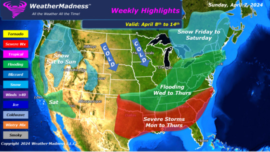
Text
Weekly Highlights for April 8 to 14 - Busy Week
The storm that will develop this week will bring severe weather across Texas into the South and heavy rains from the lower Mississippi Valley into the Northeast. The heavy rains will be more widespread across the lower Mississippi into the Tennessee Valley Tuesday into early Thursday. Widespread flooding may occur with that batch of heavy rains. Heavy rains will move northeast into the…
View On WordPress
0 notes
Photo
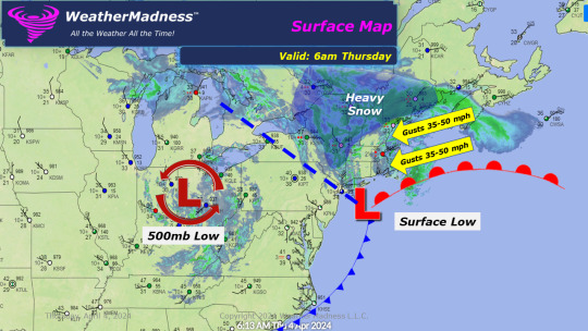
This mornings surface map from WeatherMadness.com shows the storm south of New England and the upper-level low coming across the Ohio Valley. High winds are hitting New England with heavy snow interior areas.
0 notes
Photo

Secondary storm is developing and causing thunderstorms and high winds in NJ. Not uncommon to see thunderstorms during the development process. The winds are causing tree damage and power outages. This is the storm that will bring the heavy snow to the Northeast.
0 notes
Photo

This could get serious for flooding in western and central PA where heavy rains hit overnight and more heavy rain is coming tonight into tomorrow. Thunderstorms could bring 2-4 inches of rain which will cause streams to come out.
0 notes
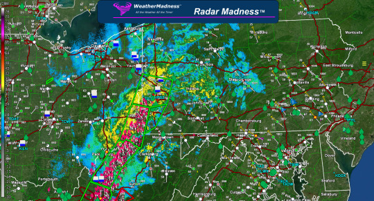
Photo
WeatherMadness.com is tracking a band of thunderstorms with wind gusts over 70 mph and possible embedded tornadoes. That band is heading towards Louisville, KY this morning.
0 notes

Photo

WeatherMadness.com is tracking the potential for tornado activity today and tomorrow. This will be a widespread severe weather outbreak associated with a powerful storm that will also bring heavy snows. Some track tornadoes are possible today.
0 notes
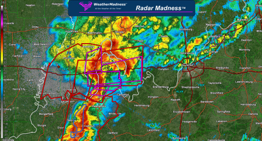
Photo
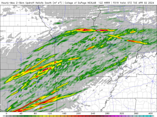
This is not good. HRRR rotation tracks would suggest long-tracked tornadoes or long swaths of damaging hail from Illinois to Oklahoma. SPC will most likely up the risk to a moderate later this morning. WeatherMadness.com is concerned for large tornadoes.
0 notes
Text
Weekly Highlights for April 1 to 7 - Major Storm this Week
This is going to be a busy week with a major storm. That storm will bring late seasons snow from the Plains through the Great Lakes into the Northeast. The Northeast will be hit hard by heavy snow with over a foot expected. The storm could explode and become a monster of a storm that blasts New England into NE PA and northern NJ with heavy snow. The cold weather and snow showers coming around the…

View On WordPress
0 notes