#pedestrian suspension bridge
Text
Would You Take a Walk on the World's Longest Pedestrian Suspension Bridge?
Looking like the narrow, rickety bridge in Indiana Jones and the Temple of Doom, this bridge presents an adrenaline rush for those brave enough to traverse it. Thankfully it has solid Swiss engineering.
Your reward is an amazing 360-degree view of the Swiss Alps, plus a gut wrenching view below you, as you stand 300 feet above the valley below.
The Charles Kuonen Suspension Bridge claims the…

View On WordPress
#Charles Kuonen Suspension Bridge#Grächen#pedestrian suspension bridge#world&039;s longest suspension bridge#Zermatt
0 notes
Text

Canada's newest & highest footbridge is not for the faint of heart
#Skybridge#Golden BC#Canadian Rockies#suspension bridge#Columbia Canyon#pedestrian walkway#Kootenays#500' high#British Columbia#scenery#mountain range#foot bridge
2 notes
·
View notes
Text
Top Less Known but Interesting facts about Switzerland
Did you know that Switzerland is home to the world's longest pedestrian suspension bridge? Or that it houses a breathtaking underground lake with crystal-clear waters? Discover the fascinating blend of languages spoken in different regions and the unique way the Swiss safeguard their ancient traditions.
#switzerland 4k#switzerland 4k video#switzerland#4k video#less known facts switzerland#switzerland is life#switzerland facts#facts about switzerland#swiss travel vlog#top 10 switzerland#schweiz#switzerland travel#switzerland travel vlog#world's longest pedestrian suspension bridge#underground lake#crystal-clear waters#blend of languages#different regions#safeguard#ancient traditions.#nini uppuluri#top less known but interesting facts about switzerland
0 notes
Photo

Unveiling the Marvel: 10 Fascinating Facts About the Brooklyn Bridge
Step back in time to the bustling era of the late 19th century, where innovation and ambition converged in the heart of New York City. The Brooklyn Bridge, an iconic symbol of engineering prowess, stands as a testament to human ingenuity. As we embark on a journey to uncover its secrets, let's explore ten captivating facts that will transport you to the enchanting world of this architectural marvel.
When was the Brooklyn Bridge completed?
The Brooklyn Bridge, a testament to enduring craftsmanship, was completed on May 24, 1883. Imagine the excitement and awe that swept through the city as this colossal structure emerged, connecting the boroughs of Manhattan and Brooklyn.
Who was the chief engineer of the Brooklyn Bridge?
The visionary behind this grand undertaking was none other than John A. Roebling, an engineer with a relentless passion for suspension bridges. Tragically, Roebling succumbed to an injury during the early stages of construction, leaving his son, Washington Roebling, to carry on his legacy and oversee the completion of the bridge.
How long is the Brooklyn Bridge?
Stretching majestically across the East River, the Brooklyn Bridge spans a total length of 5,989 feet. Its dual towers loom high above the water, a testament to the bridge's grandeur and endurance.
What are the main materials used in the construction of the Brooklyn Bridge?
The bridge's construction harnessed the power of steel and stone. The towers were built using limestone, granite, and cement, while the span itself relied on a combination of steel cables and iron. This blend of materials ensured both strength and aesthetic appeal.
How many towers does the Brooklyn Bridge have?
The Brooklyn Bridge proudly boasts two towering sentinels, each standing as a majestic guardian at the entrance of their respective boroughs. These granite-clad towers not only serve as structural anchors but also as enduring symbols of the bridge's resilience.
Can pedestrians walk across the Brooklyn Bridge?
Absolutely! The Brooklyn Bridge welcomes pedestrians with open arms. Take a stroll across its wooden-planked walkway and revel in the breathtaking panoramic views of the Manhattan skyline, the Statue of Liberty, and the bustling river below.
Is there a fee to walk or drive across the Brooklyn Bridge?
Fear not, adventurers! Walking across this historic bridge comes with no price tag. However, if you plan to drive, be prepared to pay a toll. But trust us, the pedestrian experience is unparalleled.
What is the purpose of the Brooklyn Bridge?
Beyond its functional role as a vehicular and pedestrian thoroughfare, the Brooklyn Bridge stands as a symbol of unity, linking two boroughs and transcending the waters that once divided them. Its purpose goes beyond transportation – it's a living testament to human ambition and the relentless pursuit of connection.
How tall are the towers of the Brooklyn Bridge?
Stand in awe as you gaze up at the towering giants of the Brooklyn Bridge. Each tower rises to a majestic height of 276 feet, piercing the sky and leaving an indelible mark on the city's skyline.
How many cables support the Brooklyn Bridge?
The strength of the Brooklyn Bridge lies in its cables, and there are a staggering 14,680 of them! These cables, meticulously woven and anchored, provide the bridge with the support it needs to withstand the test of time.
Conclusion:
The Brooklyn Bridge, a marvel of engineering and a testament to human resilience, continues to captivate hearts and minds. Whether you traverse its walkway, gaze at its towers from afar, or simply revel in its historical significance, the bridge remains a living testament to the spirit of innovation that defines New York City. As you navigate its storied path, remember that you're walking not just across a river but through the pages of history itself.
#Brooklyn Bridge#at sunrise#sunrise#The Brooklyn Bridge#1#New York City#new york#newyork#New-York#nyc#NY#manhattan#urban#city#USA#buildings#visit-new-york.tumblr.com#bridge
690 notes
·
View notes
Text
The Pedestrian Bridge is the only pedestrian bridge across the Dnipro River in Kyiv, connecting the embankment with Trukhaniv Island. It is a 429-meter-long suspension bridge built in 1956-1957 years. From a height of 26 meters above the water, you can admire the panoramas of the Dnipro River, the coastline with a number of monuments, and sunsets. The 7-meter-wide bridge is divided into a pedestrian and a bicycle part.
31 notes
·
View notes
Text
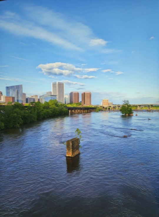
Late Spring in the River City
Richmond, Virginia (USA)
Based on a photo from May 4, 2023.
View from the pedestrian suspension bridge that runs under Lee Bridge from its north end to Belle Isle. Remnants of older, lower bridges can be seen in this area of the river. Prior to the 20th century, bridges were often taken out by river floods.
27 notes
·
View notes
Text
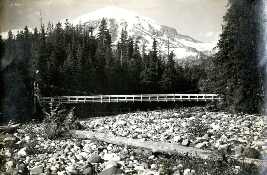
Mount Rainier National Park Archives Photo courtesy Phillip F Barrett of the Nisqually Suspension Bridge. A pedestrian bridge is faintly visible under the suspension bridge.
The Nisqually Suspension Bridge in Longmire is the only remaining timber-frame vehicle suspension bridge designed by the National Park Service. A pedestrian bridge had existed since 1911 but was replaced by a larger single-span suspension bridge in 1924 to connect Longmire to an area across the river that was developed as a campground. Superintendent Tomlinson described the newly completed bridge: “The bridge with its rustic towers supporting the cable suspension is a very fitting type of construction for a national park.” (HAER report No. WA-44).
The Nisqually Suspension Bridge was reconstructed in 1952 and 2005, using similar workmanship and materials to the earlier bridge. The Nisqually Suspension Bridge is a contributing structure in the Mount Rainier Historic Landmark District.
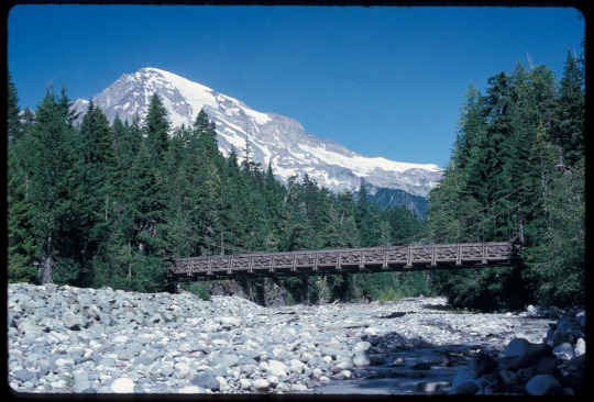

NPS Photos of the bridge in 1993 (top) and in 2021 (bottom).
The bridge is also part of the Longmire Historic Walking Tour. Stop in the Longmire Museum for a map of the walking tour or use the NPS App to follow the self-guided tour the next time you are in Longmire. Have you walked or driven over the Nisqually Suspension Bridge in Longmire?
#Historic Mount Rainier#mount rainier national park#Nisqually Suspension Bridge#Longmire#Longmire Suspension Bridge#bridge#suspension bridge#historic bridge#national historic landmark district
26 notes
·
View notes
Text
AMY’S BRIDGES

how are you supposed to cross the river in east london?
tower bridge is the last bridge over the thames until the big ol’ suspension bridge way further out. everything else here is tunnels (mostly)
for road tunnels, there’s the rotherhithe tunnel - the tenth most dangerous tunnel in europe due to lax safety features, where large vehicles including busses are banned, and “a rare example of a road tunnel where traffic, pedestrians and cyclists all share the same bore”. for the love of sin, don’t go in that hole. then there’s the blackwall tunnel for road traffic only, which only one bus route uses, and it’s under-construction neighbour the silvertown tunnel, the road traffic-only worst tunnel ever that’ll increase congestion in the docklands, won’t benefit drivers with an easier route, and won’t ease congestion out of blackwall due to not offering alternative modes bar busses
so, then there’s the tunnel of the windrush line, crossing from rotherhithe to wapping and connecting to the DLR and the jubilee. but this line serves central-south london, not south east, where it doesn’t connect to anything. its utility as a crossing in-and-of-itself is really only for the people very close to it anyway. but there’s the jubilee - when approaching from waterloo way on this is a good connection to canary wharf and the dlr. but its last station before the tunnel is at canada water, over a kilometre before the river. it’s worthless as a crossing. out of north greenwich (aka Dome) it’s got two tunnels to canary wharf and canning town - but the only reason you’ll have to cross the river there is if you happen to find yourself on the peninsula. which is why it’s fucking ridiculous that mayor disgraced journalist racist cunt built his zip line there - basically fucking mirroring a route between two tube stations. there is the elizabeth at the end of the docklands, but i don’t know if anyone would use it for the only purpose of crossing the river there, because it’s served by the only ray of hope, the DLR, which plugs greenwich into canary wharf and woolwich into the royal docks. and that’s yer lot
SO
with such awful crossings, the two halves are totally blown apart. road traffic needs to happen, yes, but in a dense cityscape people need to be on the transit systems to reduce the burden. what can we do?
the pool of london is dead. big ships do not need to go up there. london bridge has a clearance of ~9m for river boats, so any bridge we build further out doesn’t need any more clearance. this does mean the Belfast will have to move, unless we’re okay with trapping her in. the top of rotherhithe to limehouse is the best place for a mass transit-only bridge, it may be narrower than tower bridge, and connect two areas that are totally splayed open. there should be some sort of transit mode going vertically from limehouse (for the dlr), up mile end and forking to either hackney or stratford, and down to surrey quays, and then forking to greenwich for the dlr there and west laterally, either north-ish up to elephant & castle or south-ish to brixton, or better yet, both. i say mode because a lot of things could work here, but the best would be a mix of things. here’s my idea
amy fuck presents the Limehouse Bridge
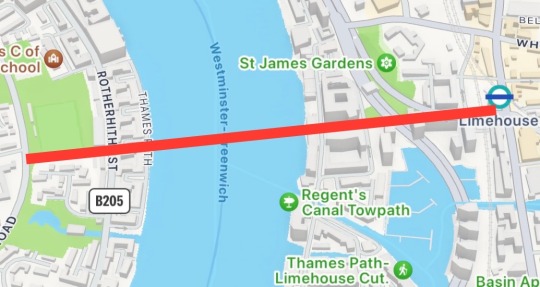
with a length-over-water of 250m, this carfree bridge connects a major transit avenue to an area prime to host connections for the people of southeast london. from the centre of limehouse, exactly where the rotherhithe tunnel’s bendy route emerges, the road south intersects with Cycle Superhighway 3. from CS3, we’ll bulldoze the tired-looking building blocking the view, and fly over to rotherhithe, bulldozing some gentrified townhouses to cut past a playing field to have plugged in to both rotherhithe street and salter road
i propose two primary pubtrans modes using the bridge: the dlr, and trams. expanding the heavy tram network, often more akin to light rail, will be vital to making the transit of central-south london as good as the north, and connecting up the dlr will cement its use in the southeast as well as the northeast
i’ll cover my dlr proposals first, though, perhaps the name docklands would have to be dropped at this point. with possibly a light rail route up north, from the limehouse bridge the light rail network can return round surrey quays to connect into greenwich, creating a vital and necessary corridor. in addition, from greenwich the route can continue to woolwich and the thamesmead extension, creating a lateral backbone to ensure usage of the dlr’s tunnels rather than the road tunnels. in addition, the lateral routes can provide vital transport for the greater southwark area with two branches, one forming a new corridor to elephant & castle, through an area with appalling connections relative to its centrality, maybe even continuing onwards to waterloo or vauxhall, or even to parliament itself. the second is to serve as an area backbone for communities, through bermondsey, peckham, camberwell and brixton, perhaps continuing to battersea or closing the loop at vauxhall. the limehouse bridge will be the linchpin of this new system, its connectivity bringing rotherhithe and the surrey quays to life, becoming a counterweight of humanity against the looming towers of canary wharf

the heavy tram systems i propose, however, i will not illustrate. because i believe they should spread out from their start in wimbledon, croydon and beckenham to form a much larger network for south london, replicating, surpassing the north’s tube, much larger than i can draw today. from limehouse bridge, the heavy tram network can integrate the areas south of the brixton spoke: crystal palace, dulwich, norwood, streatham, clapham, tooting, bromley, lewisham
all of which leaves limehouse bridge: pedestrians, cycle superhighway, light rail, heavy tram, no motor vehicles. a triumph of modern planning, the aorta of the east
so with the dlr from this bridge serving the greenwich and deptford regions, no more crossings will be needed here due to the dlr’s tunnel at the end of the isle of dogs. it’s all plugged in - and the dome has the jubilee tunnels, which could be co-opted by any new over-ground “underground” lines to serve the area if they are needed. destroy the fucking cable car. fell it. yell timber
prioritising those heavy trams now, we can connect charlton through silvertown and eastenders with a new tunnel. with the unnecessary silvertown road tunnel opening 2025, more road connections aren’t needed. so - pubtrans from charlton to newham - then heavy trams in the tunnel like it’s a miniature channel tunnel. also feature pedestrian and cycle access, obviously
there had been suggestions that the suffragette line (formerly the goblin) after barking riverside might cross the river to thamesmead, where that dlr extension might go. do it. this has to be commuter rail now, as we’re threading suburbs together. after that, we’re probably well served enough until the dartford suspension bridge
but… cars and road traffic are an unfortunate reality. with ground broken (or water broken?) on the silvertown tunnel, unholy amounts of heavy traffic are going to be funnelled through greenwich and poplar. removing passengers who can be removed can only help us so much. the unfortunate truth is a woolwich road bridge, replacing the ferry, is a good idea. toll it to high hell obviously, but it should help ease congestion that has now been caused by the silvertown. with plentiful other passenger connections, and ensuring anti-car policies are kept up to make sure only people with a damn good reason are driving through the area, this bridge could be helpful. but of course, without any of that, it would be a polluting, congesting disaster. but we were on a spending spree anyway
anyway. bridges
12 notes
·
View notes
Text


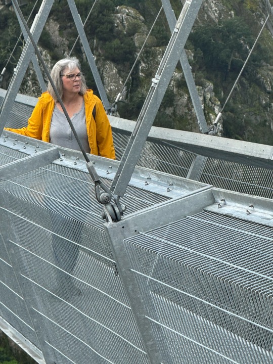


In the abstract, walking across a pedestrian suspension bridge didn’t sound like a big deal when it first came up in our living room. In reality it wasn’t, TBH it was terrifying.
I played it off like it was just something to fill the time before lunch but when this fucking beast rose up out of the mist like Godzilla, I was a seriously worried I might freeze up. I never thought I or it would fall. The bridge is rated to hold the weight of thousands of people at a time and is practically immune to any weather they get there. It does not look risky and I’m not especially afraid of heights except in the way a rational person recognizes heights equal danger. Still I felt fear.
After what felt like interminable warnings by the guide, “Don’t run, don’t jump up and down, don’t lie down, don’t climb onto the sides” I didn’t hesitate to start across or do any of those insane things. Fear of failure wins again.
The metal decking was wet and combined with the constant slope down to the middle of the bridge over 850’ away, the footing felt precarious. Of course even if I’d fallen, I wouldn’t fall off the bridge. Rational thought meet nearly six hundred feet of height. At first I held my phone in my left hand and gripped the bridge railing with my right. I could feel my legs wanting to shake and there was some noticeable sway in the bridge even though the wind was light. The park guide had said if you begin to have trouble don’t look down, focus on the far side. I thought, well what would be the point of that. The point became very clear very quickly but by the middle, I was no longer holding on instead focusing on the view and pics of the view.
Right after she was born, I bought a picture for my first granddaughter, who was waiting safely back under a large pavilion barely in sight of the bridge. It said, Brave is not a feeling.
In the abstract, walking across this bridge still doesn’t seem a big deal. There is no doubt the trail we hiked along the valley on miles of wet wooden stairs was far more dangerous. I don’t feel any sense of accomplishment for having done it. Simply put, the others wanted to do it and I wanted to be with them. Lemmings?
Once we were on the other side, I realized the guide had followed us over. No doubt he would have assisted anyone who needed it. No one did. He began to give us a presentation about the bridge, its history, cost to build, time it took, etc. He paused for questions. Not having attended closely to his prepared comments I asked, “So this is the longest pedestrian suspension bridge in the world.”
He hung his head and as if ashamed admitted two other bridges had been completed recently that were longer. But this one was still the highest!
When questions lagged, I asked if anyone had run the bridge thinking - if something is there someone will run it. I understood they couldn’t allow tourists to run on it but well, it’s 1,700 feet long across a scenic valley so.
The guide looked astonished and with a degree of reprimand exclaimed, You cannot run the bridge! He went on. Your perception of the slope cannot cope while running and you will feel you are running into the air and you will fall!
Oookay then.
So then I asked had anyone BASE jumped or bungee jumped the bridge? This question seemed to visibly upset him and D turned and gave me that look. You know that look. You don’t really know what it means specifically but you know you best stop whatever you’re doing. Fear.
It is not allowed! He said
<sigh> humans never do things unless it is allowed.
Looking for a pic with this saying for my 3 year old granddaughter. Stop messing up my hair. It is not allowed!
8 notes
·
View notes
Text


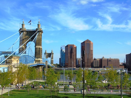
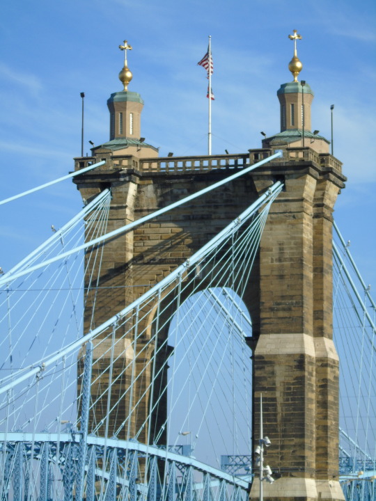

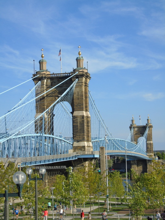


On December 1, 1866, pedestrians walked upon the Covington and Cincinnati Suspension Bridge, known locally only as “The Suspension Bridge,” for the first time.
#Covington and Cincinnati Suspension Bridge#1 December 1866#Cincinnati#USA#Ohio#Kentucky#Covington#Cincinnati-Covington Bridge#travel#John A. Roebling Suspension Bridge#John A. Roebling#architecture#cityscape#Ohio River#summer 2016#original photography#landmark#tourist attraction#anniversary#US history#vacation
7 notes
·
View notes
Text
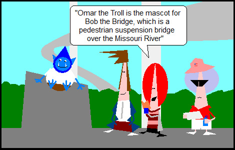
[Image description: Preview panel for the comic strip at the link. The Doctor, skinny blue incarnation, and Donna of Doctor Who and another tourist are examining a statue of a blue troll under a bridge. Donna is reading from a pamphlet: "Omar the Troll is the mascot for Bob the Bridge, which is a pedestrian suspension bridge over the Missouri River." Unfortunately there are not image descriptions at the main Hero Of Three Faces site. End description.]
The Hero of Three Faces is fanfiction crossovers, but it’s comic strips with stick figures, but they’re triangles.
Preview panel only. Click here for full cartoon.
Or see the on-site navigation tutorial.
Or see this blog’s FAQ, or my archive tumblog’s FAQ.
Cartoons may contain unmarked spoilers.
Cartoons linked from Tumblr 10:00 (Central US time) daily are the previous day’s new update and the posts are pinned to the top of this blog.
Cartoons linked from Tumblr 22:00 daily are from the archive and the posts are pinned only during annual summer hiatus of new updates.
Thanks for reading.
6 notes
·
View notes
Text
At least 26 people have been killed and more are feared missing after a railway bridge under construction collapsed in north-eastern India, officials said.
The incident occurred near the town of Sairang, in the state of Mizoram.
Up to 40 workers were at the site when part of the bridge collapsed, according to local media reports.
The cause of the incident is not yet clear and the railway authority has opened an investigation. Three people have so far been rescued.
That includes an injured worker who had to be brought down from the top of one of the bridge's 100m-high (328ft) pillars.
The incident happened over the Kurung River, about 20km (12 miles) from the city of Aizawl, Mizoram's capital.
"All possible assistance is being given to those affected," said Prime Minister Narendra Modi's office in a statement.
The government will pay some 200,000 rupees (£1,900; $2,400) to the next of kin of those killed, it added.
The victims are all from West Bengal, according to railway officials.
"Words cannot express the depth of sorrow and sympathy for the families affected by this tragic event," said Mizoram's Home Minister Lalchamliana.
The Khamrang-Sihhmui railway line will be 51km long and is due to be completed in December after work began nearly two years ago.
Accidents on these kinds of construction sites are not uncommon in India.
In October last year, more than 140 people were killed when a pedestrian suspension bridge collapsed in India's western state of Gujarat.
4 notes
·
View notes
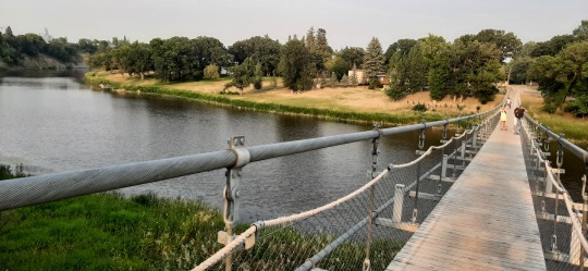
Text
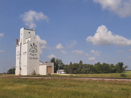
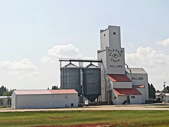
South Manitoba
I left Winnipeg not too late in the morning and finally got myself into the Prairies proper driving in south-western direction. The flat landscape reminded me of the Netherlands, but in place of church spires indicating where the villages are, here it's grain elevators that tower above the horizon... conveniently with the name of the town written on them! 😁
Funny enough, one of the villages was called Holland, complete with a tulip-sign and a windmill 🤣

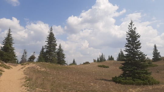
First destination of the day was Spruce Woods provincial park near the town of Glenboro, but Gmaps directed me initially to a farmhouse south of the highway rather than to its proper location 10 km north! The same happened a few more times in the following days for both Manitoba and Saskatchewan parks so that taught me to ask directions - something we don't do often anymore! 😜
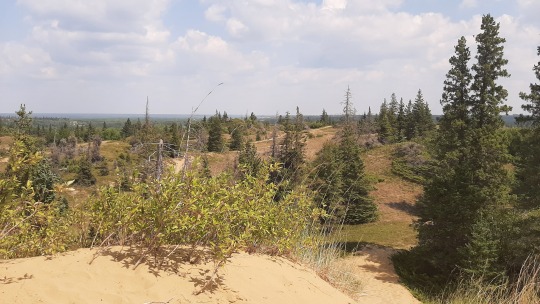
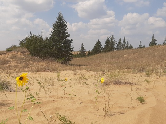
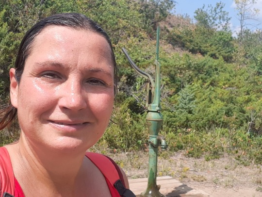
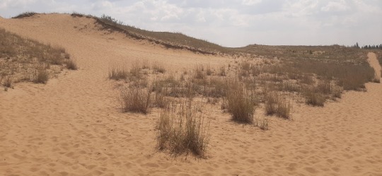
The highlight of the park are the Spirit Sands; the remnants of what used to be an expansive inland dune area deposited by a glacial lake 10,000 years ago. Although the dunes still shift with the wind, most of the area is being reclaimed by vegetation as, contrary to a desert, it actually receives quite a lot of rain. Having grown up with dunes along the North Sea in the Netherlands, it looked familiar but rather than a cooling sea breeze it was scorching hot! There were luckily some hand-pumped water wells along the trail that friendly hikers operated while I put my head under the cold stream 😃, however once I had seen the "Devil's Punch", a little pond filled by underground springs, I cut the hike short and returned to the car AC.


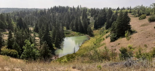
Afterwards, I cooled down some more under a tree at a picknick area on an oxbow lake (I was too tired to walk down to the water & take a pic 😅).
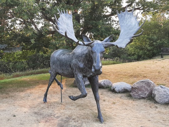
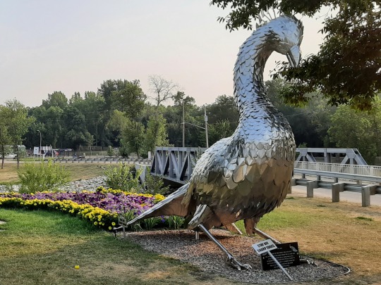
Having anticipated that I might not feel my best the day after Harman's wedding 😆, I only had a short drive further to the municipal campground of Souris, which has a cute swinging bridge, at 604 ft supposedly to be Canada's longest suspension pedestrian bridge (?!?), the first one built in 1906. The town had also nice sculptures of a moose and peacock, of which apparently there's many in the village although I saw none. This was the first time that I had stayed on a municipal campground and although busy with a pool & lots of running kids, I had a nice spot on the river and it was actually quite good!
That's it for Manitoba for now as I would be driving into Saskatchewan the next day, but I'll explore the central/north areas on my way back.
Wildlife: lots of grasshoppers everywhere!
SUPs: none
Hikes: one at Spruce Woods
3 notes
·
View notes
Text
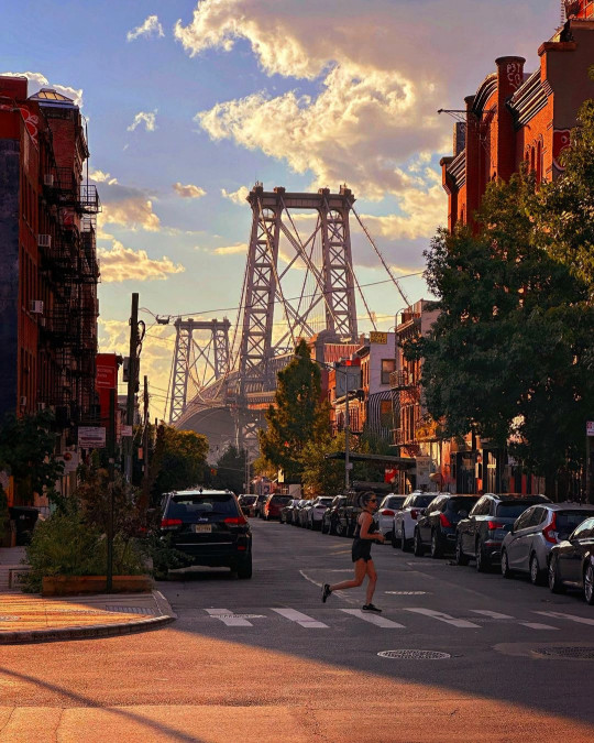
The Williamsburg Bridge remains a beloved and functional part of New York City's infrastructure, offering more than just a physical connection between boroughs. It weaves together the social, cultural, and economic fabric of the city while serving as a reminder of the city's enduring spirit and resilience.
Accessibility for Bicyclists: In recent years, the Williamsburg Bridge has become increasingly popular among cyclists. The addition of dedicated bike lanes and paths has made it a key route for those commuting between Brooklyn and Manhattan by bicycle. This has contributed to the city's efforts to promote sustainable transportation options.
Emergency Services: The Williamsburg Bridge, like other major bridges in New York City, is equipped with emergency evacuation plans and protocols. It is considered an essential route for emergency vehicles and personnel during crises or natural disasters.
Cultural Influence: Beyond its practical role, the Williamsburg Bridge has had a profound cultural influence, particularly in the Brooklyn neighborhood it connects to. Williamsburg, with its vibrant arts scene, has become synonymous with the bridge's name, and it has featured prominently in local art, music, and literature.
In Popular Culture: The Williamsburg Bridge has appeared in numerous movies, TV shows, and music videos. Its distinctive architecture and picturesque views have made it a favorite location for filmmakers and artists looking to capture the essence of New York City.
Connecting Diverse Communities: The bridge has played a crucial role in connecting diverse communities in Manhattan and Brooklyn. It has been a conduit for the exchange of cultural influences, economic activity, and social interactions.
Historical Preservation and Restoration: Various organizations and government agencies have been involved in preserving and restoring the bridge to ensure its longevity. Efforts have included repainting the bridge, restoring its architectural features, and maintaining its structural integrity.
Design Features: The Williamsburg Bridge's towers are constructed of steel, and its suspension cables are made of wire rope. The bridge's overall design showcases elements of the Beaux-Arts architectural style, with ornamental details and decorative flourishes.
Maintenance Challenges: Maintaining a bridge of this size and age is an ongoing challenge. The bridge requires regular inspections, repairs, and upgrades to keep up with modern safety standards and the demands of urban transportation.
Future Developments: As New York City continues to evolve, the Williamsburg Bridge remains a vital part of the city's infrastructure. Future developments and improvements may include further enhancements to pedestrian and cyclist facilities, as well as ongoing efforts to reduce environmental impacts.
Centennial Celebrations: The Williamsburg Bridge celebrated its centennial in 2003 with various events and activities to mark its 100th anniversary. This milestone offered an opportunity for New Yorkers to reflect on the bridge's historical importance.
Artistic Expressions: Over the years, the Williamsburg Bridge has been a canvas for artistic expressions. Street art and graffiti have adorned its support structures and pedestrian walkways, contributing to the bridge's cultural identity.
Traffic Congestion and Alternatives: Like many urban bridges, the Williamsburg Bridge experiences traffic congestion during peak hours. This congestion has prompted discussions about transportation alternatives, such as improved public transit options, to ease the burden on the bridge and reduce environmental impacts.
Hurricane Sandy and Resilience: The bridge, like other infrastructure in New York City, faced significant challenges during Hurricane Sandy in 2012. The storm surge resulted in flooding and temporary closures. In response, the city has explored ways to enhance the resilience of critical infrastructure, including the Williamsburg Bridge, to future extreme weather events.
Iconic Landmark: The Williamsburg Bridge is not just a transportation link but also an iconic symbol of New York City's skyline. Its unique silhouette and the way it frames views of the city have made it a subject of admiration for photographers, artists, and tourists alike.
Community Engagement: The Williamsburg Bridge has been the focus of community engagement and activism. Local residents and organizations have advocated for improvements, safety measures, and the preservation of its historical and cultural significance.
Economic Impact: The bridge's role in connecting Manhattan and Brooklyn has had a significant economic impact on both boroughs. It has facilitated the movement of goods and people, supporting businesses and industries on both sides of the East River.
Night Illumination: The Williamsburg Bridge is often illuminated at night, casting a stunning glow over the East River. The changing colors and lighting schemes have been used to mark special occasions and holidays, enhancing the bridge's visual appeal.
Symbol of Progress: Throughout its history, the Williamsburg Bridge has symbolized progress, connectivity, and the spirit of innovation. It reflects the dynamism of New York City as it continues to evolve and adapt to the needs of its residents.
The Williamsburg Bridge stands as a testament to both engineering innovation and the enduring cultural significance of infrastructure in urban life. It has served as a lifeline for generations of New Yorkers, connecting people, neighborhoods, and opportunities across the East River.
<Previous page - Williamsburg Bridge - Next page>
#Williamsburg Bridge#Bridge#Brooklyn#new york city#new york#new-york#newyork#manhattan#nyc#ny#urban#city#usa#United States#buildings#travel#journey#outdoors#street#architecture#visit-new-york.tumblr.com
230 notes
·
View notes
Text
Day Seventy-two


Up early this morning, it's a long day ahead!
It's one of thise rare days where I have a specific destination in mind, so it's on to the supermarket in Queensferry to grab some handy provisions and get at it.
Starting off by jumping onto the busy A548, it's ploughing on through a few towns along the River Dee. It's a lot of slogging in busy traffic but not too many options for this stretch as the bike route proper follows this road, and the wind is starting to increase with the temperature.
At Baglit the cycle route heads up and over some big hills a little inland, so I say hell to that and keep cracking on at the road.
The road isn't exactly great fun, with lots of hedges and trees blocking the views, but finally we break through the foliage lining and emerge out to the coast at the Port of Mostyn.
Emerging from cover does mean the wind starts to become more noticeable, and a strong breeze is blustering down the coastline. But there is a great view back over the water to see the view of yesterday's ride.
Past Ffynnongoyw, there's a right turn and it's finally away from the traffic and on to some great riding around the cycle trails to Talacre Beach, before riding on through the dunes and across the golf course.
Hitting Prestatyn, we get some more nice promenade riding all the way down to Rhyl. Some stretches are alas under building work, so there's a little meandering involved to get around them whilst being slapped around by the wind.
Over the River Clwyd, there's more nice riding away from the traffic along the beaches, along with a good few more sections of construction work diversions. But the sun is shining and the view over to Colwyn Bay is very pretty.
Past the impressive sight of Gwyrch Castle on the hillside, I have a short stop to help someone out with a flat tyre. One thing I do enjoy with cycling is the camaraderie amongst riders and it's very common for others to check in that someone is ok or needs help if they're stationary.
Riding on, it's up some steeper sections up over the cliffsides, before yet more construction work sends me off on a diversion into Old Colwyn.
I've had enough with the promenade routes being constantly blocked off, so elect to say hell and stick back to the proper cycle route once more, which leads on through the busy Colwyn Bay and west alongside the expressway.
It's around some beautiful hills through this area before coming out at Llandudno Junction, and with the wind still battering around I take a break with a bit of shelter here. Today is some hard work!
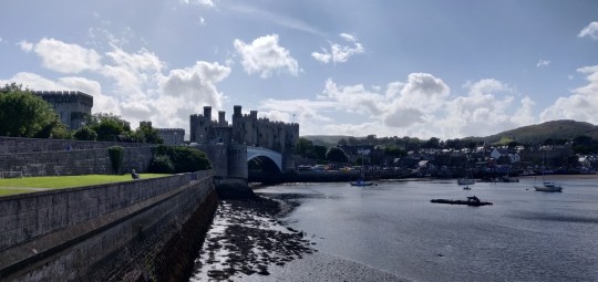
Crossing over the River Conwy, I get to ride past the awesome Conwy Castle and have a lovely jaunt around the riverside whilst heading past Conwy, then it's back out to the sea as the path works its way past some impressive hills.
Past Penmaenmawr the cliffsides offer little space, and some interesting pathing is in place to sandwich a major dual carriageway, a rail line, and pedestrian & cycle access in all together, but somehow it's managed.
At Abergwyngregyn there's no other through road apart from the dual carriageway, so the route leads uo inti the foothills overhead, making for some lobg climbs and tiring work. It gives a nice view of Anglesey, but damn it's tough going.
Eventually it's downhill once more, crossing back over the expressway and zooming in to Bangor to check out their pier, and then riding up and around to the Menai Suspension Bridge.
Across the bridge and I'm on the island if Anglesey! Whilst I'm not riding around the entire island, I am making a stopoff at a place I've wanted to check out for maby years - Llanfairpwllgwyngyllgogerychwyrndrobwllllantysiliogogogoch. With the evening wearing on, most other tourists are having dinner and I have no issues getting a photo done with the sign.
Not much further left today! Back to the bridge I ride, then it's a ride down the Menai Strait along to the historic castle town of Caernafon, with a nice ride past its beautiful castle.
A final push around the hills nearby and I eventually arrive at my destination for the day - the home of the wonderful Nerys! I have been given a lovely hot shower and a damn amazing steak, and have a few nights' R&R ahead to allow the back to heal up a bit more!
That's the entire damn north coast of Wales down in one day! I'm kinda shocked at myself, especially with the hideous headwind that has been causing so much extra effort, but I'll take it!
Have a good weekend!
3 notes
·
View notes
Text
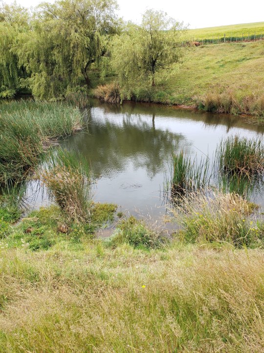
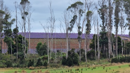
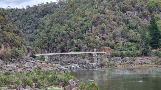
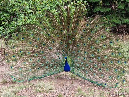
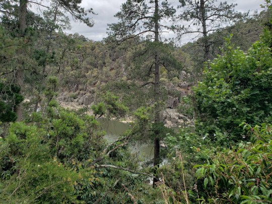
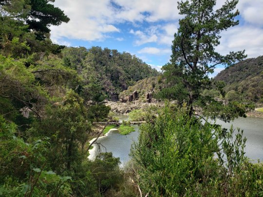
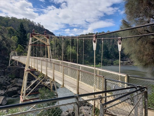
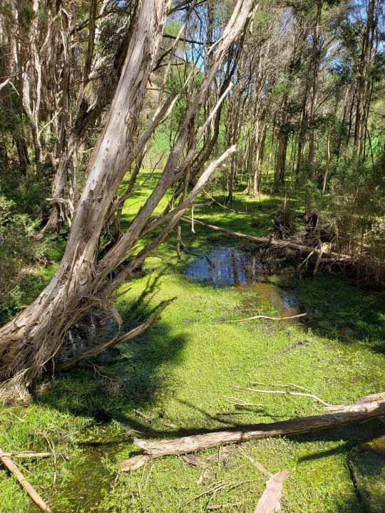
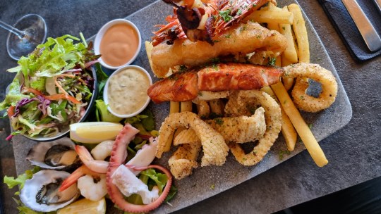
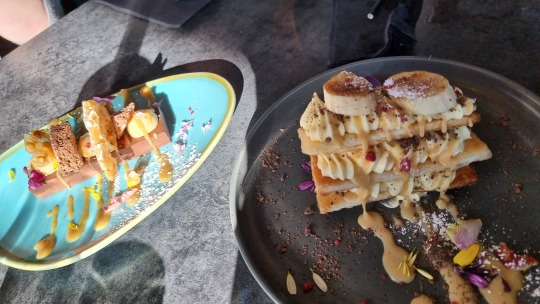
Photos from Days 12-13 of Australia vacation: Launceston
Day 12
Top photo: On the way out of Scottsdale, here's the platypus in the pond. You probably can't quite see it at this size, but it's there!
Row 2: Lavender farm in the distance
Row 3: A view of Cataract Gorge from the chairlift
Row 4: peacock
Row 5: various scenic looks at Cataract Gorge, including the pedestrian suspension bridge
Day 13
Row 6: Tamar Island Wetlands
Row 7: Dinner and dessert!
2 notes
·
View notes
Last Seen Blogs

thegirlwhodiesalot
looking to the sky

furuxomokiva
Untitled

sanctum-06
Sanctum

thegodsuburbia
Alex

faerieroyal
𝖎’𝖉 𝖗𝖆𝖙𝖍𝖊𝖗 𝖇𝖊 𝖒𝖊