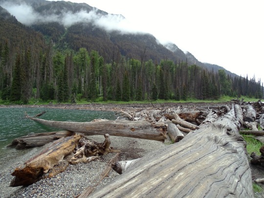
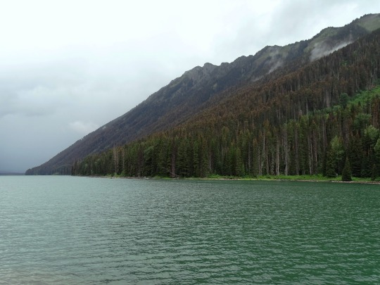
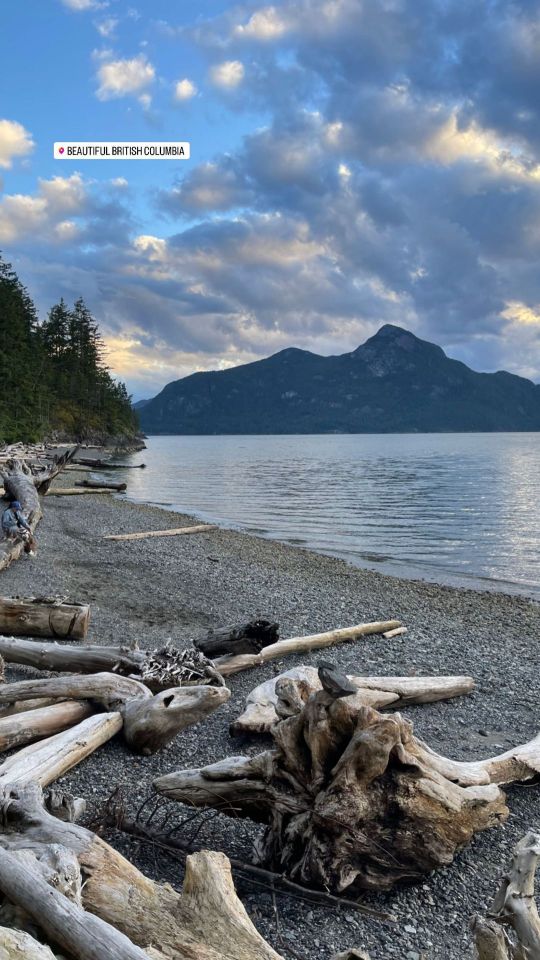
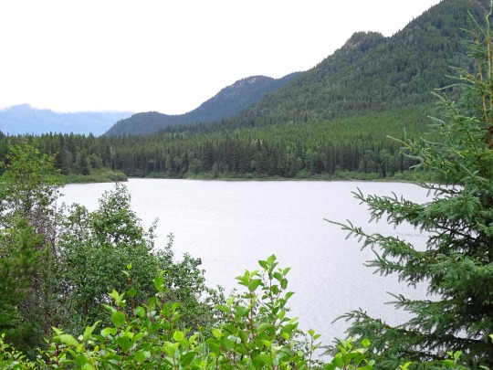
#lillooet lake
Text


Clouds (No. 1104)
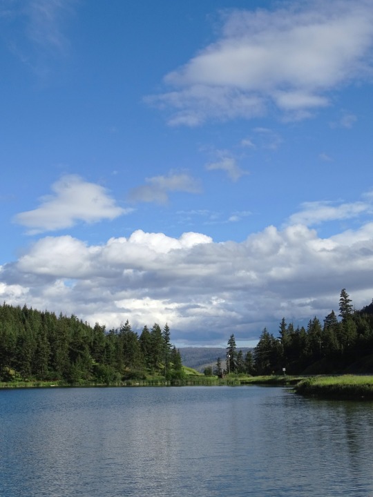
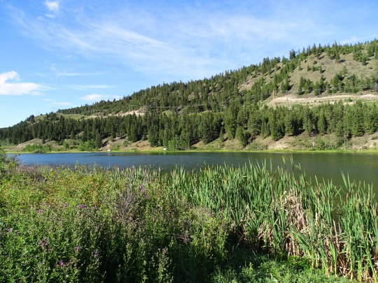
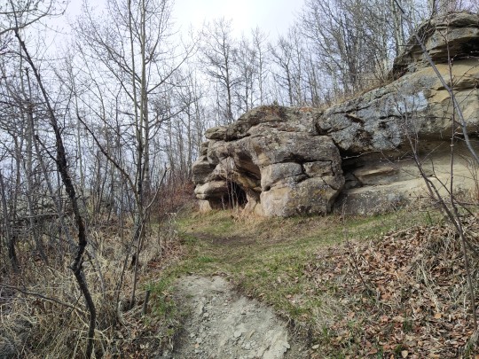
Duffey Lake, BC (five pics)
6 Mile Lake, BC (five pics)
#Duffey Lake#Squamish-Lillooet#travel#original photography#vacation#tourist attraction#landmark#landscape#clouds#nature#flora#Canada#summer 2023#British Columbia#blue sky#countryside#forest#tree#woods#fir#pine#overcast#Cayoosh Range#Lillooet Ranges#dead wood#6 Mile Lake#Thompson Nicola Region
1 note
·
View note
Note
Top 5 archaeological sites in your province
Well, I hope everybody's settled in for an illustrated archaeology infodump, because this one got long...
But thanks for asking, this was fun to put together.
1. Tse'k'wa (Charlie Lake Cave)
Partly because I worked there as a field school TA. Also because it's one of The Coolest sites. Look up the raven burials, they're incredible. Basically it's a rock shelter overlooking a filled in ravine used by Clovis-ish peoples moving north through the ice-free corridor 12,000 years ago. Our work there was looking at the top of the hill above, where the activity might be more recent. This is the home of the northernmost Clovis point in existence, among many other cool artefacts.
It's a very cool place, and you can usually visit if you call ahead and use the driveway instead of the unauthorised path up the bank.
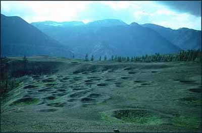
2. Keatley Creek
This site might be the closest thing to a precontact interior plateau city we'll ever find. The house pits are so close together they almost overlap in places. A community this size was possible because of Keatley Creek's prime location on the Fraser salmon run and the nephrite jade celt industry across BC (think like axe blades and chisels, etc.) that they supplied with top quality material. A disaster that impacted the salmon run is probably why the site was abandoned, but they left behind lots of evidence of the good times for us to find.
Here's the site in modern times courtesy of Simon Fraser University:
And this is the inside of a modern reconstruction Lillooet pithouse like the ones those depressions used to be:

3. Hagwilget Canyon
There hasn't been a ton of work done on this site, but oral histories document it as a key trade hub in precontact BC. People from all over the northwest would come to the canyon to trade and socialise annually. And, with all those people moving through, you needed proper infrastructure, such as:
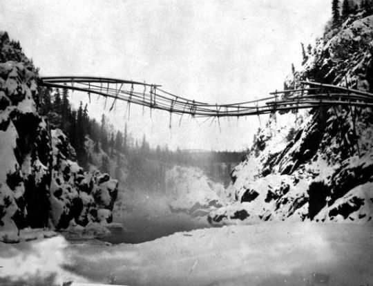
The first (and best, if you ask me) Hagwilget Canyon Bridge.
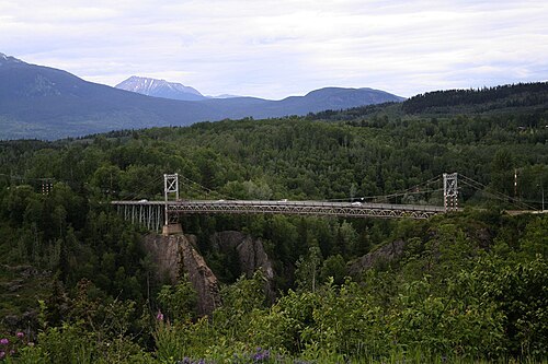
And here's the new one, in case you need context for how massive a crossing this really was:
This thing was built before white people arrived, from natural materials, and stuck around for generations. It was an incredible feat of engineering, and I'm so glad somebody thought to get pictures.
4. Kilgii Gwaay (Haida Gwaii)
This is a cool site for a bunch of reasons. It's about 10,000 years old. It was occupied before cedar was well established on BC's coast. It was only occupied for about 50 years. It's a wet site with amazing preservation. It's been under the ocean for most of its history.
Once upon a time there were people who lived on a nice little patch of shore between a pond and the sea. They fished in the ocean and hunted bears and drove wooden posts into the ground to make their homes and drying racks. They made stone tools. And then the water came up, slow but unrelenting, and made them leave. The grandparents who held little kids hands as they walked away were probably the people who had first picked this place as a home. Everything we know about them came from the short time they lived there and the things they left behind.
And then the water covered it, and kept bones and tools and wood stakes safe for ten millennia. Only luck and climate and geology working together made it possible for us to find it again. It's like a tiny, perfect Atlantis. I wonder how many generations after heard stories about the village the sea took back.
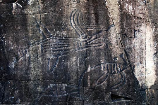
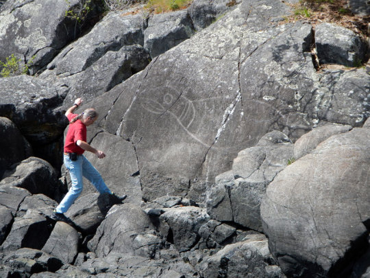
5. Vancouver Island Petroglyphs
Had to have at least one hometown hit on this list, right? There's rock art all over the place in BC, but some of the ones on the Island are phenomenal. They're pictures carved into rock faces, sometimes flat, sometimes vertical. They tend to heavily feature mythical creatures.
Here's some from Petroglyph Park near Nanaimo:
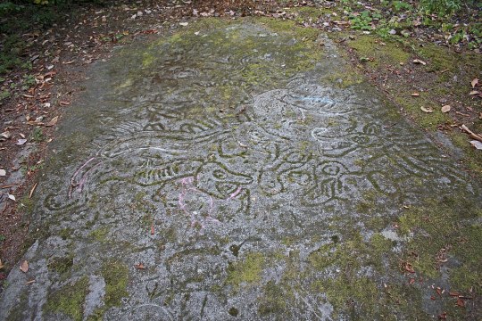
I like the chalk additions. You can't really damage carvings ground into bedrock and exposed to the elements for hundreds of years with sidewalk chalk, so why not let kids be kids?
This is the petroglyph wall at Sproat Lake Park:
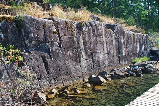
There's a dock set up in front of the wall to view the pictures. They must have been very cool to see from a canoe before the dock went in. Here's a close-up of some of the creatures:
And here's a really big seal near Sooke, BC. Haven't seen this one personally, but it looks amazing:
#archaeology#British Columbia#top 5 asks#thanks for asking!#(you had to know this would be lecture length right?)
18 notes
·
View notes
Text
The Village of Pemberton has declared a state of local emergency because of flooding.
An evacuation order has been issued for six properties along Airport Road, which include some residential properties, a golf course and adventure tourism companies connected to the airport.
Evacuation alerts are also in place for about 20 other properties in the Pemberton Valley, as several waterways swell with melting snow.
The unseasonable warm spell ushered in by a stream of moisture-laden Pacific air has set daily temperature records and accelerated snowmelt in southwestern B.C.
The village says properties at risk include those along the Lillooet, Ryan, Miller, Green and Birkenhead rivers, Pemberton Creek and Lillooet Lake.
Continue Reading.
Tagging: @politicsofcanada
Date of article: January 30th, 2024.
28 notes
·
View notes
Text
Wednesday, March 13, 2024 Canadian TV Listings (Times Eastern)
WHERE CAN I FIND THOSE PREMIERES?:
LITTLE WING (Paramount+)
TEEN MOM: FAMILY REUNION (MTV Canada) 8:00pm
THE AMAZING RACE (CTV) 9:30pm
NEW TO AMAZON PRIME CANADA/CBC GEM/CRAVE TV/DISNEY + STAR/NETFLIX CANADA:
CBC GEM
QUEEN OF THE DEUCE
NETFLIX CANADA
BANDITS (MX)
MLB SPRING TRAINING (SN) 1:00pm: Pirates vs. Jays
TENNIS
(TSN/TSN3) 2:00pm; Indian Wells - Round of 16
(TSN/TSN5) 9:00pm; Indian Wells - Round of 16
NHL HOCKEY
(SN) 7:30pm: Predators vs. Jets
(SN1/SNWest) 10:00pm: Capitals vs. Oilers
(SNPacific) 10:30pm: Avalanche vs. Canucks
NBA BASKETBALL
(TSN4) 7:0pm: Raptors vs. Pacers
(SN Now) 7:30pm: Nuggets vs. Heat
(SN360) 8:30pm: Warriors vs. Mavericks
(TSN4) 10:00pm: Lakers vs. Kings
PWHL HOCKEY (TSN5) 8:00pm: Boston vs. Minnesota
WILD CARDS (CBC) 8:00pm (SEASON FINALE): Ellis is drawn into a case involving Max, her ex, and a world-famous Imperial egg, where a cat-and-mouse heist tests their friendship, their partnership, and their trust in each other.
FARM DREAMS (Nat Geo Wild) 8:00pm (SERIES PREMIERE): Indy Officinalis helps Grace and Will Lyons make their homestead a success.
ALLEGIANCE (CBC) 9:00pm: A call to a motel leads Sabrina and Vince into the underbelly of a migrant worker trafficking ring.
RED EARTH UNCOVERED (APTN) 9:00pm: Prior to leaving for Central Alberta to investigate strange encounters, Hayley speaks with a ghost expert for advice; guided by Doc's warning not to go out at night, Hayley probes mysterious evil sightings in Maskwacis.
LANDS ENCHANTED (APTN) 9:30pm: Lil'wat Nation members Maxine Bruce and Tammie Jenkins explore the sacred fishing grounds of Lillooet Lake, cherished by generations of Lil'wat fishers.
BIG BROTHER CANADA (Global) 9:30pm
TELLING OUR STORY (documentary) 9:00pm: The worldview of First Peoples, their ancestors, languages and traditional knowledge; the ingenuity that has been passed on for thousands of years through oral tradition.
FIXER TO FABULOUS: ITALIANO (HGTV Canada) 10:00pm (SERIES PREMIERE): Dave and Jenny travel to Italy to take on their biggest project yet, helping friends who've poured their savings into a Tuscan farmhouse rental; they begin to restore the villa, but soon find out how challenging a renovation across the world can be.
#cdntv#cancon#canadian tv#canadian tv listings#wild cards#allegiance#red earth uncovered#lands enchanted#big brother canada#telling our story#tennis#mlb baseball#nhl hockey#nba basketball
5 notes
·
View notes
Video

flickr
RDCs at Dawson Creek por Joe McMillan
Por Flickr:
In 1987, the West Coast Railfans Association (WCRA), a Canadian group, sponsored a RDC tour of the entire BCR. For about $600, we would be treated to seven solid days of train riding, lodging, meals, etc. Steve and I, plus some of our friends, couldn't get our checks mailed in fast enough. What a bargain!! We were to tour the main line from North Vancouver to Fort Nelson, a distance of 979.4 miles, plus all the branches, except the Dease Lake Extension beyond St. James, which was closed by then. (As noted earlier, Steve and I had already done the line west of St. James.) We left North Van on September 13, 1987, and returned on September 19th. We spent each night in a town along the way. The town usually had a banquet for us and put on an after-dinner show. We were assigned three BCR RDCs for our trip and they stayed with us the entire time. Our three cars were coupled to BCR Train 2 at Lillooet on the last day, so we had five RDCs that day. On September 15, we traveled the 61.1-mile Dawson Creek Subdivision from Chetwynd to Dawson Creek, B.C., The cars are spotted next to the Northern Alberta Railway station shortly before our departure back to Chetwynd. We tied up that night at Fort St. John–––photo by Joe McMillan with Steve Patterson and a bunch of other friends.
2 notes
·
View notes
Video
This looks like the same lake from 6x01 set (Nina Defilla IG story, British Columbia) ->
And a picture from it:
It’s a Lillooet Lake in BC, where they were shooting 6x01 (and a fucking 7x16 too).
3 notes
·
View notes
Text
The combination of high fire intensity, strong winds and air mass instability near Lillooet on Aug. 17 resulted in the formation of a fire whirl (otherwise known as a fire tornado) over Gun Lake, British Columbia
1 note
·
View note
Text


Sicamous and Blind Bay on Shuswap Lake, one of the many massive lakes in BC’s interior. We stop in Sicamous for a swim- the air temperature is again in the high 30s. The sand is too hot to stand on.
We camp in Blind Bay at a holiday spot meant primarily for boaters (the beach was muddy and the water murky) but at least a breeze came off the lake. We did have a very fine meal at the Timber Restaurant.
The sunset is courtesy of a wildfire raging 100 miles away in the Lillooet area.
0 notes
Link
[ad_1] Descrease article font size Increase article font size Two new evacuation orders are in effect as sweltering heat and dry conditions fuel wildfires across the province. The latest from the Squamish-Lillooet Regional District as the Casper Creek wildfire burns dangerously close in the Seton Portage area.The order issued at 10:30 PM covers all properties in Electoral Areas “A” and “B”, including the Seton Lake and Shalalth communities west of Lillooet. Map of Evacuation Area. Squamish-Lillooet Regional District Residents in the area are being told to leave immediately. Story continues below advertisement The SLRD has issued an EVACUATION ORDER due to the Casper Creek Wildfire K71535 in Electoral Area A & B. Properties included are as outlined on the attached map. More info, visit:https://t.co/3yr7ZknOuZ@EmergencyInfoBC @BCGovFireInfo pic.twitter.com/dRLbGZHl3p— Squamish-LillooetRD (@slrd_bc) August 16, 2023According to the BC Wildfire Service, the Casper Creek wildfire was spotted July 11th and is currently burning out of control at 4,650 hectares.They say fire behavior increased significantly along the northeast flank of the fire Tuesday, fueled by strong winds and extremely hot and dry conditions.The spread has forced the closure of Mission Mountain Road between the Terzaghi Dam and Shalath, after the blaze crossed over the route.Meanwhile, in the Okanagan, another evacuation order was declared southwest of the Village of Keremeos due to the threat of two wildfires. Map of evacuation area. Regional District of Okanagan-Similkameen The order covers 13 properties in Electoral Areas “B” and “G” along the Ashnola River and Ewart Creek Road, including Cathedral Provincial Park, Cathedral Lakes Lodge and the Snowy Protected Area. Trending Now Trump, 18 others charged under Georgia’s RICO Act. Here’s what that means LGBTQ policy in N.B. schools violates Charter rights of kids: child advocate Story continues below advertisement Those in the areas under the order are being told to leave immediately.EOC Update: Gillanders Creek wildfire (K51680), Crater Creek wildfire (K52125) Wednesday, August 16, 2023, 12:05 am More info: @BCGovFireInfo @EmergencyInfoBC pic.twitter.com/xLOahl1FYW— RDOS EOC (@EmergMgtRDOS) August 16, 2023An evacuation alert is also in effect for 74 properties in the area along the Similkameen River.The Gillanders Creek and the Crater Creek wildfires are both considered out of control, producing significant smoke seen across cities in the Interior.According to the BC Wildfire Service, the Gillanders Creek blaze was spotted on July 13th and is burning 480 hectares roughly 12 kilometers southwest of the Village of Keremeos.The Crater Creek fire is even larger at 697 hectares, burning 18 kilometers southwest of the Village of Keremeos. Story continues below advertisement [ad_2]
0 notes
Link
[ad_1] Officials in the Squamish-Lillooet Regional District are urging people ordered to evacuate Tuesday due to a wildfire to leave immediately, describing the situation as "critical." The Downton Lake wildfire is burning out of control in the Bridge River Valley north of Pemberton and all properties in the area of Gun Lake and Lajoie Lake were ordered to evacuate Tuesday afternoon. "Members of the Royal Canadian Mounted Police and other applicable agencies will be expediting this action," the order issued at 1 p.m. said. However, the regional district posted an urgent update to its social media channels around 6:30 p.m. reiterating the order to flee. "Situation regarding Gun Lake/Lajoie Lake evacuation order is now CRITICAL. You must evacuate the area IMMEDIATELY!" the posts said, telling people to report to emergency services in either Lillooet or Whistler. "Failing to leave can endanger you and first responders," reads a subsequent tweet from BC Emergency Info. The blaze has more than doubled in size since Monday, when flames raced eastward on the steep northern hillsides above Gun Lake and its more than 200 cabins. The BC Wildfire Service estimates that the fire has grown to 875 hectares. The blaze has triggered a "full" response, according to the BCWS, which means "there is threat to public safety and/or property and other values, such as infrastructure or timber." Situation regarding Gun Lake/Lajoie Lake Evacuation Order is now CRITICAL. You must evacuate the area IMMEDIATELY! Avoid the fire on the west side of Gun Lake. Evacuate Gun Lake area via Gold Bridge & onward toward Lillooet & Whistler. Register for ESS in Lillooet or Whistler. pic.twitter.com/qa3SxgXM3x — Squamish-LillooetRD (@slrd_bc) August 2, 2023 With files from The Canadian Press. [ad_2] Source link
0 notes
Text


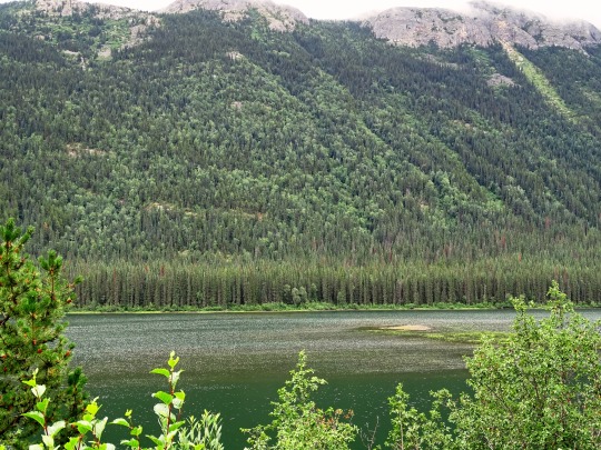
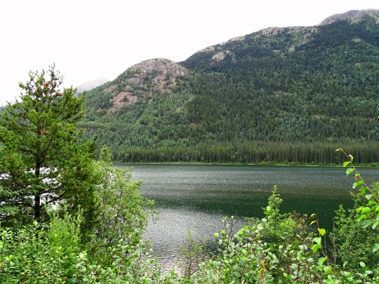


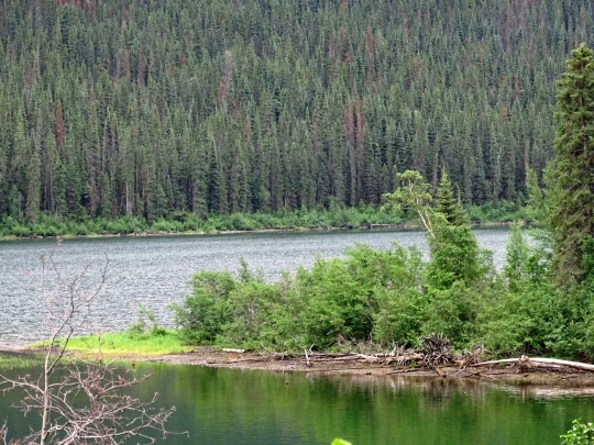


Pinetree Lake, BC (No. 1)
The British Columbia Interior, popularly referred to as the BC Interior or simply the Interior, is a geographic region of the Canadian province of British Columbia. While the exact boundaries are variously defined, the British Columbia Interior is generally defined to include the 14 regional districts that do not have coastline along the Pacific Ocean or Salish Sea, and are not part of the Lower Mainland. Other boundaries may exclude parts of or even entire regional districts, or expand the definition to include the regional districts of Fraser Valley, Squamish–Lillooet, and Kitimat–Stikine.
Home to just under 1 million people, the British Columbia Interior's 14 regional districts contain many cities, towns, airports, and associated regional, provincial, and national parks connected by the province's highway and railway network. The region is known for the complexity of its landforms, the result of millions of years of tectonic plate movements. The ecology of the region is dominated by temperate coniferous forest with patches of alpine tundra found atop its numerous mountain ranges.
The Northern Interior Plain is a continuation of the interior plain that takes in nearly all of Alberta and southern Saskatchewan and Manitoba. It extends from Monkman Provincial Park and Tumbler Ridge in the south, to Hudson's Hope and the Williston Lake in the west, to Fort St. John and Charlie Lake in the north. The term is used to mean the whole of the Northeastern Interior east of the Rockies, including Fort Nelson and other parts of the Liard drainage, and before W.A.C. Bennett Dam included the upper Peace River through its canyon between Finlay Forks and Hudson's Hope.
Source: Wikipedia
#Pinetree Lake#original photography#travel#vacation#tourist attraction#landmark#landscape#countryside#nature#Canada#summer 2023#fir#the North#cityscape#forest#woods#flora#British Columbia#wildflower#Stikine Highway#clouds#British Columbia Highway 37#Skeena Region#lake shore#Skeena Country#British Columbia Interior
12 notes
·
View notes
Text
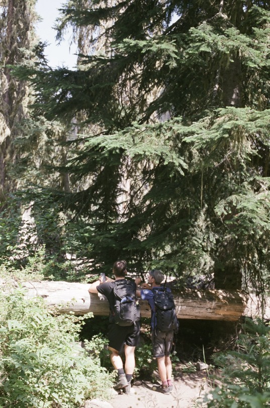
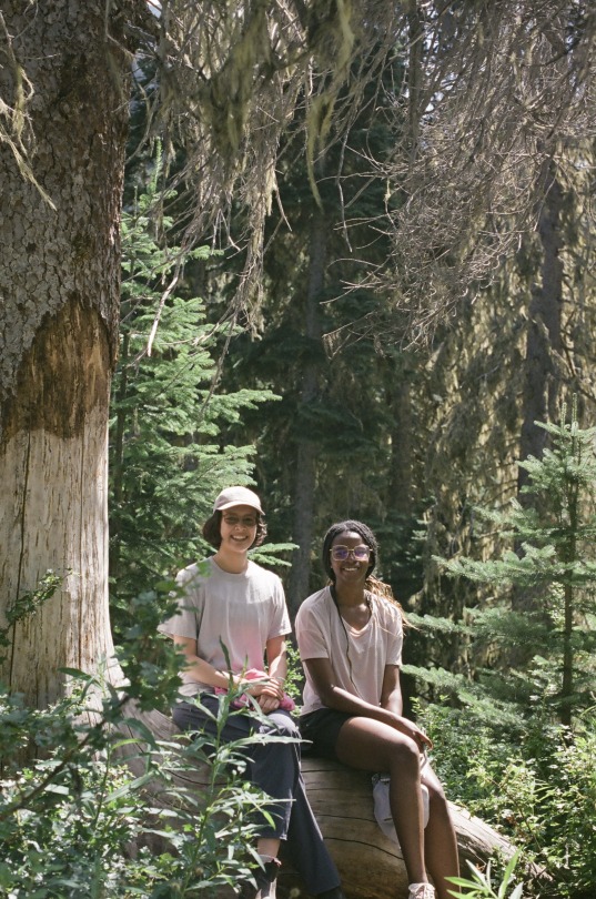


Last week, we went on our lab camping trip to Birkenhead Lake Campsite located in Lillooet! The weather was perfect and we hiked up to the upper Joffre lake the second day!
Special thanks to Lizzie and Fredi for making this happen, Christophe for initiating the plan, and lastly Tolu, Christophe, and Fredi for driving (and everyone else for the great vibes 🥰)
Here's a couple of film photos I took during the trip using Canon AE-1 with Fujifilm Pro 400H (my last roll of this iconic discontinued film!)🎞️🏕️✨🏞️
-Britany
0 notes
Text
An evacuation order has been expanded in the Casper Creek Area to include all residents in Seton Portage, B.C., and the Tsal’alh First Nation due to an out of control wildfire.
The Casper Creek fire is burning about 33 kilometres west of Lillooet, near Anderson Lake.
It was spotted on July 11, and has quickly grown into a “wildfire of note.” On Friday, the blaze was measured at 528 hectares. It has since spread on the east, northeast and southeast flanks, growing to 1,200 hectares in size.
The Squamish-Lillooet Regional District and the Tsal’alh chief and council are ordering residents in the area to leave immediately.
They say local accommodations are limited and ask residents to make arrangements to stay with loved ones, if possible. [...]
Continue Reading.
Tagging: @politicsofcanada
#cdnpoli#Casper Creek#fire tw#Seton Portage#Tsal’alh Nation#First Nations#British Columbia#natural disasters
24 notes
·
View notes
Text
Alouette Lake Complete Guide
Alouette Lake
Alouette Lake is located in Maple Ridge, British Columbia, Canada. Nestled in the midst of British Columbia’s stunning wilderness lies a mountain group known as the Golden Ears. Among its scenic wonders is Alouette Lake, originally named Lillooet Lake and created in 1926 when the Alouette Dam was built. The lake stretches for 16 kilometers on a northeast-southwest axis and boasts an…

View On WordPress
0 notes
Link
Three more avalanches came down in the Pemberton area, Saturday afternoon, sending two people to hospital with serious injuries.
Pemberton Search and Rescue told Global News the slides were triggered in the Duffy Lake region of Highway 99 between Pemberton and Lillooet around 2 p.m.
According to a Provincial Health Services Authority spokesperson, one ambulance and one air ambulance responded to the first avalanche and one person was taken to hospital by ground in stable condition.
0 notes
Conversation
Canadian Daily High Temperature Records Tied/Broken 10/19/22
Claresholm, Alberta: 81 (previous record 72 2003)
Elk Island National Park, Alberta: 76 (previous record 67 2014)
Ft. Saskatchewan, Alberta: 86 (previous record 73 1978)
Lloydminster, Alberta: 71 (previous record 67 2014)
Okotoks, Alberta: 75 (previous record 73 2014)
Unincorporated Parkland County, Alberta: 81 (previous record 71 1999)
Picture Butte, Alberta: 79 (previous record 77 2003)
Unincorporated Strathcona County, Alberta: 71 (also 71 1999)
Vegreville, Alberta: 74 (previous record 69 2014)
Unincorporated Wainwright District, Alberta: 73 (previous record 68 2014)
Unincorporated Yellowhead County, Alberta: 73 (previous record 65 1999)
Campbell Island, British Columbia: 61 (also 61 2018)
Campbell River, British Columbia: 68 (previous record 64 1999)
Unincorporated Central Kootenay District, B.C.: 62 (previous record 60 2021)
Unincorporated Central Saanich District, B.C.: 65 (previous record 64 2003)
Chetwynd, British Columbia: 67 (previous record 65 1999)
Comox, British Columbia: 65 (previous record 63 1954)
Unincorporated Fraser Valley District, B.C.: 66 (also 66 2014)
Kimberley, British Columbia: 68 (previous record 61 1989)
Kitasoo Indian Reserve 1, British Columbia: 61 (previous record 59 2015)
Kitimat, British Columbia: 58 (previous record 57 1964)
Unincorporated Kitimat-Stikine District, B.C.: 65 (previous record 62 1964)
Lake Cowichan, British Columbia: 75 (previous record 70 1974)
Port Hardy, British Columbia: 68 (previous record 60 2014)
Port Moody, British Columbia: 68 (previous record 67 1978)
Powell River, British Columbia: 64 (previous record 63 2014)
Quinsam 12 Reserve, British Columbia: 71 (previous record 63 1999)
Santa Gretrudis Boca Del Infierno Provincial Park, B.C.: 63 (also 63 2015)
Silver Star Provincial Park, British Columbia: 63 (previous record 58 2021)
Unincorporated Squamish-Lillooet District, B.C.: 70 (previous record 69 1999)
Unincorporated Squamish-Lillooet District, B.C.: 70 (previous record 65 2018)
Terrace, British Columbia: 60 (previous record 59 2015)
Tofino, British Columbia: 65 (previous record 64 1999)
Ucluelet, British Columbia: 65 (previous record 64 1999)
Whistler, British Columbia: 70 (previous record 64 1978)
Mactaquac Provincial Park, New Brunswick: 65 (also 65 1998)
Unincorporated Eagle Creek Municipality, SK: 69 (also 69 2014)
Leroy, Saskatchewan: 72 (previous record 70 2014)
Unincorporated Northern Saskatchewan District, SK: 68 (previous record 63 1977)
Unincorporated Northern Saskatchewan District, SK: 55 (previous record 48 1994)
0 notes
Last Seen Blogs

sunjaywoning
i dedicate to you, my life

butfirstchai
butfirstchai

wofocasac
Untitled

iitsdream
Its Dream

sugarafterhours
Bee