#historic building preservation services
Text
#historic restoration services#Historic Preservation and Restoration#Historic building preservation services#repair or restore historic building materials
2 notes
·
View notes
Text
"Cody Two Bears, a member of the Sioux tribe in North Dakota, founded Indigenized Energy, a native-led energy company with a unique mission — installing solar farms for tribal nations in the United States.
This initiative arises from the historical reliance of Native Americans on the U.S. government for power, a paradigm that is gradually shifting.
The spark for Two Bears' vision ignited during the Standing Rock protests in 2016, where he witnessed the arrest of a fellow protester during efforts to prevent the construction of the Dakota Access Pipeline on sacred tribal land.
Disturbed by the status quo, Two Bears decided to channel his activism into action and create tangible change.
His company, Indigenized Energy, addresses a critical issue faced by many reservations: poverty and lack of access to basic power.
Reservations are among the poorest communities in the country, and in some, like the Navajo Nation, many homes lack electricity.
Even in regions where the land has been exploited for coal and uranium, residents face obstacles to accessing power.
Renewable energy, specifically solar power, is a beacon of hope for tribes seeking to overcome these challenges.
Not only does it present an environmentally sustainable option, but it has become the most cost-effective form of energy globally, thanks in part to incentives like the Inflation Reduction Act of 2022.
Tribal nations can receive tax subsidies of up to 30% for solar and wind farms, along with grants for electrification, climate resiliency, and energy generation.
And Indigenized Energy is not focused solely on installing solar farms — it also emphasizes community empowerment through education and skill development.
In collaboration with organizations like Red Cloud Renewable, efforts are underway to train Indigenous tribal members for jobs in the renewable energy sector.
The program provides free training to individuals, with a focus on solar installation skills.
Graduates, ranging from late teens to late 50s, receive pre-apprenticeship certification, and the organization is planning to launch additional programs to support graduates with career services such as resume building and interview coaching...
The adoption of solar power by Native communities signifies progress toward sustainable development, cultural preservation, and economic self-determination, contributing to a more equitable and environmentally conscious future.
These initiatives are part of a broader movement toward "energy sovereignty," wherein tribes strive to have control over their own power sources.
This movement represents not only an economic opportunity and a source of jobs for these communities but also a means of reclaiming control over their land and resources, signifying a departure from historical exploitation and an embrace of sustainable practices deeply rooted in Indigenous cultures."
-via Good Good Good, December 10, 2023
#indigenous#native americans#first nations#indigenous rights#tribal sovereignty#solar energy#solar power#solar panels#renewable energy#green energy#sioux#sioux nation#sustainability#climate hope#electrification#united states#hope#good news
2K notes
·
View notes
Text

(A replica of the 1830 locomotive “Planet,” built in 1999, to which “New Era” is mostly mechanically identical.)
Located at the Silverburn Railway Museum are countless irreplacable and historic items. None can truly claim to be the most significant of all, (just like children,) but in terms of age, one always comes first by virtue of how time works, (just like children.)
In this regard, “New Era,” a dinky 2-2-0 tender engine, is very special: She is the oldest surviving locomotive in Wallundic history. In fact, she’s the first locomotive to ever set wheel in the Liberal Republic, in 1845. She was built roughly fifteen years earlier for the Liverpool and Manchester Railway and ran under a different name which has since been lost to time. It’s known that she was withdrawn in 1841, and she was found idle, grimy but mechanically sound when agents of the embryonic Eastern Railway came to purchase her in late 1845.
Getting her to Wallund in time was achieved “by less than saintly means,” and she was very helpful in building up her new home railway. At this time her English name was stripped and the name “New Era” was applied at the extravagant Opening Day festivities on August 1st, 1846. She was also inducted as the newborn ER’s No. 1.
New Era was shortly afterwards painted into the Liberal Republic colors: blue boiler cladding with white rims on the wheels, red wheel spokes and bufferbeams. It had been intended to give her a red smokebox and funnel too, but heat-resistant red paint was scarcely a thing yet. This was applied decades later when it came about, giving the engine a “cotton candy” look.
Surprisingly long was New Era a genuine working engine: even as workloads multiplied in size and engines following her became larger and faster, she was still sought after for ER Directors’ Trains and was a traditional steed for Wallundic Presidents’ rail travel. She was finally withdrawn and immediately preserved for posterity in 1935. Despite being out of service and static since then, the ER never gave her number to another engine and she remains their No. 1, (deservedly, in the author’s opinion.)
58 notes
·
View notes
Text
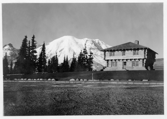
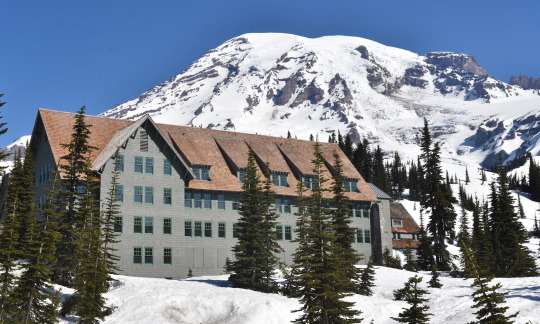
Mount Rainier National Park Archives Photos of the Sunrise South Blockhouse (part of the stockade group) in 1930.
May is National Historic Preservation Month, when we celebrate the places that preserve a piece of our shared history. Mount Rainier National Park was designated a National Historic Landmark District in 1997 as no other park has preserved as much of an intact example of early park planning as Mount Rainier. Beginning in the late 1920s, the master plan for Mount Rainier was the first and most complete national park master plan to be developed and implemented in the National Park Service. The park was treated as a synthetic whole – not a group of fragmented locations – and this consistent design can still be seen in the buildings, roads, bridges, trails, and developed areas.

Mount Rainier National Park Archives Photo of the Paradise Inn in 1940-41.
Mount Rainier National Park is also home to five buildings that are independently designated National Historic Landmarks: the Longmire Administration Building, Longmire Community Building, Longmire Service Station, Paradise Inn, and Yakima Park Stockade Group (home to the Sunrise Visitor Center). Each of these represent unique examples of early park architecture. Have you visited all five buildings?
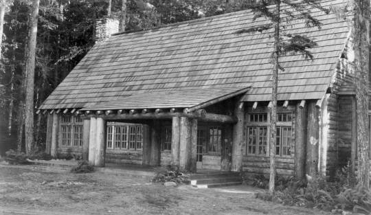

Mount Rainier National Park Archives Photos: Longmire Community Building circa 1927 (left) and Longmire Service Station in 1929 (right).
Learn more about the historic district at https://go.nps.gov/MountRainierHistoricDistrict
#Historic Mount Rainier#mount rainier national park#NPS Rustic Architecture#rustic architecture#National Historic Landmark#National Historic Landmark District#National Historic Preservation Month#history#historic building#Paradise Inn#Longmire
38 notes
·
View notes
Text
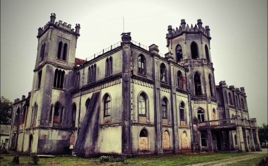


Samples of abandoned palace architecture of Ukraine:
Tereshchenko Palace
The village of Chervone, Andrushiv district, Zhytomyr region.
The style of the palace is Neo-Gothic. It was built at the beginning of the 19th century at the expense of the Polish nobleman Adolf Groholsky. The estate was bought by Ukrainian industrialists and philanthropists - Tereshchenko brothers, who expanded the palace and the park.
The palace began to fall into disrepair with the arrival of communist regime. After 1917 here were located a children's boarding school and vocational school. Later the building survived a fire.
Nowadays, the palace of the Groholsky-Tereshchenkos belongs to the women's monastery of the Holy Nativity of Christ. In addition to the palace, the stables, the left wing and the fountain have been preserved.
Oosten-Saken Palace
Kyiv region, Kyiv-Svyatoshinskyi district, between Myrotske and Nemishaeve villages.
It is believed that the palace was built in the 19th century at the expense of Count Karl Saken. It was an Ancestral estate. The count's descendants had the surname Osten-Saken, which is where the conventional name of the estate comes from.
In Soviet times, the palace housed a biochemical plant. After a fire broke out at the factory, the palace burned down and only the walls remained.
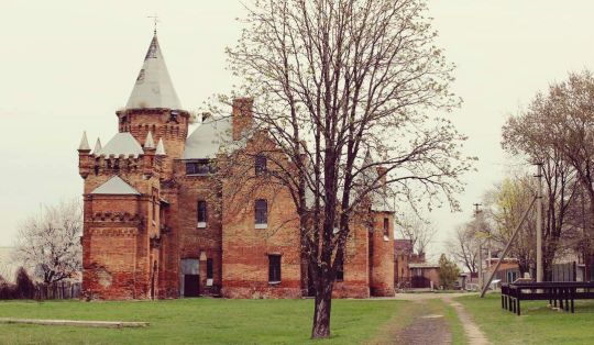
Dakhovsky Palace
Village of Leskovo, Monastyryshche district, Cherkasy region.
The style of the building is Neo-Gothic. Leskiv Palace was built at the expense of magnate Casimir Dakhovsky in the middle of the 19th century.
The complex consists of a palace, outbuildings, service premises and stables. In June 2013, the palace received the status of a historical and cultural reserve of state importance.
Palace of the Muravyov-Apostles
the outskirts of Khomutets village, Myrhorod district, Poltava region. The estate was built at the beginning of the 19th century by a descendant of Ukrainian hetman Danylo Apostol - diplomat Ivan Muravyov-Apostol. The palace is surrounded by considerable French park. Ivan Muravyov-Apostol left the estate and went abroad after the failure of the Decembrist uprising.
Popov estate
Vasylivka town, Zaporizhzhia region.
The style of the preserved buildings is Neo-Gothic. Vasyl Popov, a general of the Russian Empire, founded a settlement here at the end of the 17th century. In the 19th century, the grandson of the general, who was also named Vasyl, developed the estate and built numerous farm buildings.
Source: https://tsn.ua/tourism/10-zanedbanih-palaciv-ta-zamkiv-ukrayini-yaki-mozhut-zniknuti-nazavzhdi-1040310.html
#ukraine#eastern europe#architecture#palace#history#palace architecture#abandoned buildings#abandoned#abandoned palaces
59 notes
·
View notes
Text
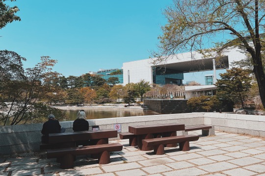
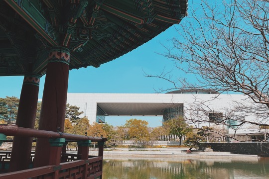
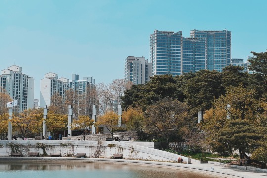
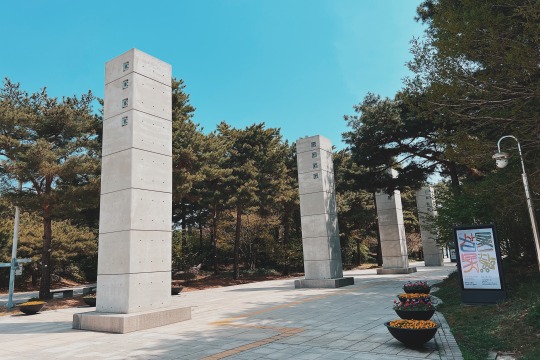
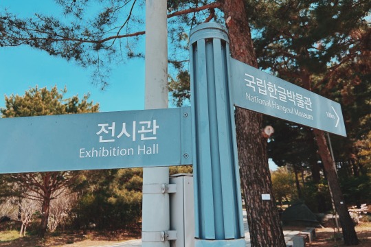
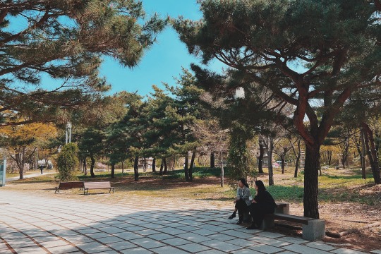
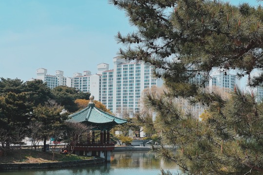
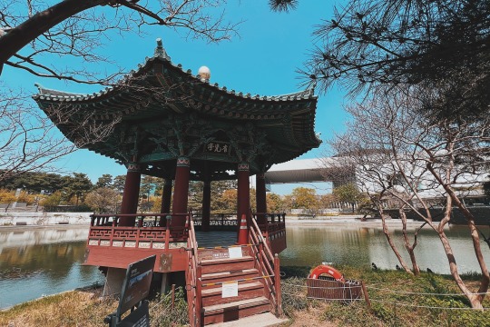
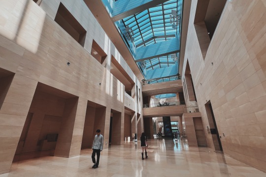
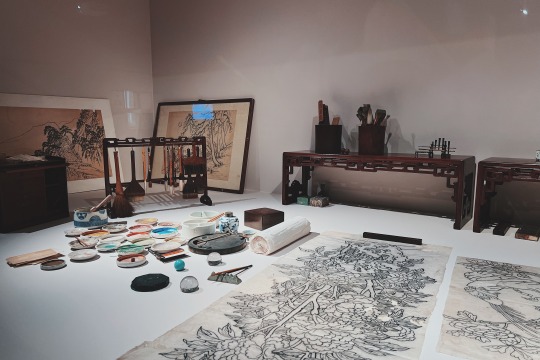
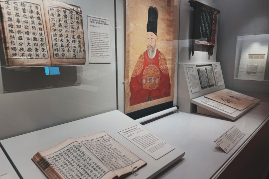
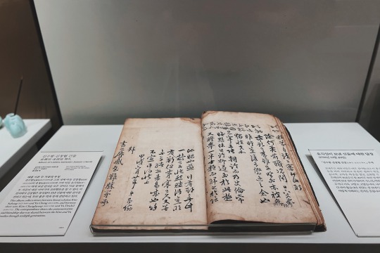
The National Museum of Korea is the most representative and extensive museum in Republic of Korea. The museum holds an immense collection: it has more than 410,000 historically valuable and highly aesthetic relics ranging from the Paleolithic Age to the early 20th century, and more than 12,000 masterpieces of its collection are always on display in its permanent exhibition hall.
The museum also houses a Children's Museum, where visitors can learn more about the nation's history through educational programs and experiences. The outdoor grounds feature pagodas and other stone artworks too large to be on display inside.
In addition to galleries with a wide array of national and international pieces, the National Museum of Korea is a stage for a number of cultural activities related to collection, preservation, research and analysis, social training, academic publications, intercultural exchange programs, concerts, and more.
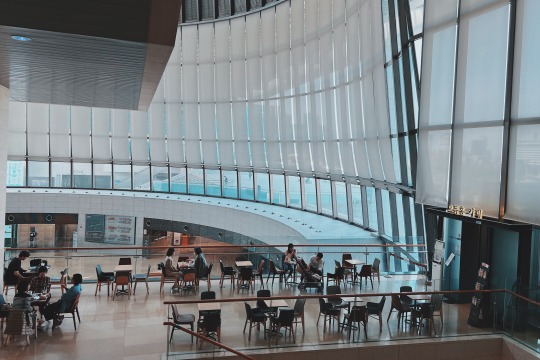
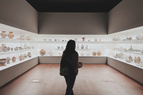
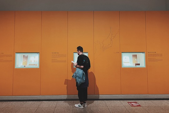
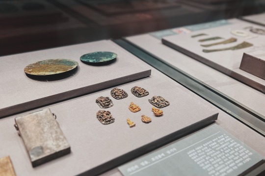
The museum has six galleries: Prehistory and Ancient History, Medieval and Early Modern History, Donated works, Calligraphy and Painting, World Art, and Sculpture and Crafts Galleries.
The National Museum of Korea was established in 1945. In 2005, the museum extended and reopened on a site of 307,227㎡ (building area: 45,438㎡) in Yongsan, Seoul. Since its rebirth as a “cultural complex,” the National Museum of Korea not only to preserves and exhibits precious relics, but also provide various educational programs and cultural events.
The National Museum of Korea has a number of important cultural materials related to Silk Road (both land and maritime) from Central Asia, East Asia, and Korea. In particular, its unique collection of Sinan Undersea Relics which is a valuable source of information for study of ancient trade between China, Korea and Japan. A sunken Chinese trading ship was discovered in 1975, in the Korean southwest coast near Sinan, Jeollanam-do Province. The ship, carrying trade goods produced on orders from the Kyoto area, sank on its way to Japan from Ningbo in Zhejiang Province, China in 1323. About 30,000 maritime Silk Roads objects were excavated; they are 14th century Chinese goods, including celadon wears, coins, metal artifacts, medical artifacts, and many other types of objects.
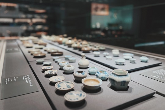
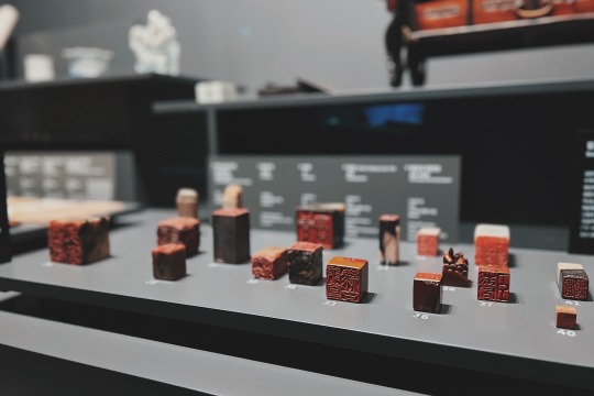

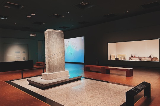
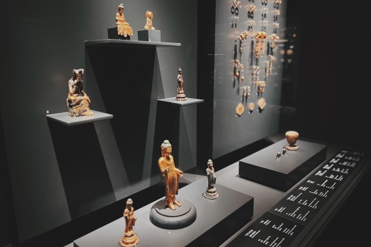
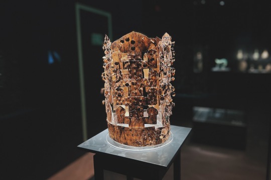
Visitors can appreciate its vast collection; numerous national treasures of Korea are exhibited including Pensive Bodhisattva (a Korean National Treasure), Goryeo Celadon Openwork Burner, Ten-Story Pagoda from Gyeongcheonsa Temple Site, and Gold Crown from Silla.
In addition to the programs and contents respects mentioned above, the National Museum of Korea would be one of the best museums in the world, in terms of the size of the museum (biggest one in Asia and sixth in the world), the annual attendance figures (1st in Asia, 10th in the world in 2009), additional facilities (a theater, a cafeteria, a museum shop, education hall, conference rooms), and digital services for the exhibition (PDA, MP3 and kiosk system).
Opening hours: Monday, Tuesday, Thursday, Friday & Sunday : 10:00 am ~ 6:00 pm (Final entrance at 5:30 pm); Wednesday & Saturday : 10:00 am ~ 9:00 pm (Final entrance at 8:30 pm)
20 notes
·
View notes
Text
Meadow near 91st and Central Park West

Meadow near 91st and Central Park West
Central Park West, often abbreviated as CPW, is a prominent and prestigious avenue located along the western edge of Central Park in Manhattan, New York City. It is one of the city's most iconic and sought-after residential addresses, known for its historical significance, architectural grandeur, and cultural importance. Here are some key details about Central Park West:
Location: Central Park West runs parallel to Central Park, starting at 59th Street in the south and extending to 110th Street (also known as Cathedral Parkway) in the north. It forms the western boundary of Central Park and offers stunning views of the park's landscape.
Historical Significance: Central Park West is lined with a diverse array of architectural styles and historic buildings, many of which date back to the late 19th and early 20th centuries. It is often considered a showcase of New York City's architectural history.
Architectural Diversity: Along Central Park West, you'll find a mix of architectural styles, including Beaux-Arts, Renaissance Revival, Art Deco, and more. Notable buildings include The Dakota, The San Remo, The Eldorado, and The Beresford, all of which are famous for their architectural splendor and the notable residents who have called them home.
Cultural Institutions: Central Park West is home to several renowned cultural institutions, including the American Museum of Natural History, one of the largest and most prestigious natural history museums in the world. The Museum of Arts and Design (MAD) and the New-York Historical Society are also located along this avenue.
Residential Prestige: Central Park West has long been associated with luxury living. The buildings along this avenue often feature spacious apartments with park views, elegant pre-war details, and a high level of service. Many notable individuals, including celebrities and business moguls, have chosen to reside in this area.
Transportation: Central Park West is well-connected to the rest of Manhattan via public transportation. It is served by several subway lines, including the A, B, C, D, and 1 trains, making it relatively easy to access other parts of the city.
Scenic Beauty: Residents and visitors of Central Park West enjoy breathtaking views of Central Park, with its lush greenery, serene lakes, and iconic landmarks. The proximity to the park provides a sense of tranquility and natural beauty amidst the bustling city.
Cultural and Entertainment Events: Due to its proximity to Central Park and its cultural institutions, Central Park West is often a focal point for cultural and entertainment events, including parades, concerts, and film screenings.
Real Estate: Real estate along Central Park West is highly sought after and can command some of the highest prices in the city. The area is known for its co-op and condominium buildings, each with its own unique character and charm.
Historic Preservation: Many of the buildings along Central Park West are designated as New York City landmarks or are part of historic districts, ensuring their preservation and protection. This commitment to preserving the architectural heritage of the avenue contributes to its enduring charm.
Cultural Impact: Central Park West has been featured prominently in literature, film, and television, further cementing its status as an iconic New York City location. The Dakota, in particular, gained worldwide fame as the residence of John Lennon and Yoko Ono and was the site of Lennon's tragic shooting in 1980.
Parks and Recreation: In addition to Central Park itself, the avenue offers access to several smaller parks and green spaces, making it a desirable place for residents who value outdoor activities and leisure.
Educational Institutions: Central Park West is also home to some educational institutions, including the Fiorello H. LaGuardia High School of Music & Art and Performing Arts, renowned for its performing arts programs.
Shopping and Dining: The avenue features a mix of upscale shops, restaurants, and cafes, offering residents and visitors a range of dining and shopping options within walking distance.
Central Park West Parades: Central Park West is a popular route for parades and processions in New York City. One of the most famous parades is the annual Macy's Thanksgiving Day Parade, which passes through this avenue on its way to Herald Square.
Transportation Hub: Central Park West provides convenient access to various transportation options, making it easy for residents to explore other parts of Manhattan and beyond. It's also a popular location for taxi and rideshare pick-ups.
Community and Neighborhood: The avenue is surrounded by vibrant neighborhoods, including the Upper West Side and Morningside Heights. These neighborhoods offer a mix of cultural attractions, dining, and shopping options that enhance the quality of life for those living on or near Central Park West.
In summary, Central Park West is a quintessential New York City avenue known for its historical significance, architectural beauty, cultural institutions, and luxurious residential offerings. It provides residents and visitors with a unique blend of urban living and access to the natural beauty and cultural richness of Central Park.
Central Park West remains a symbol of New York City's cultural and architectural richness, offering a blend of history, luxury, and natural beauty. Whether you're strolling along the avenue, enjoying the views of Central Park, or exploring the cultural institutions and dining options, Central Park West provides a unique and enriching experience in the heart of Manhattan.
#Meadow#Central Park#Central Park West#New York City#new york#newyork#New-York#nyc#NY#manhattan#urban#city#USA#buildings#visit-new-york.tumblr.com
216 notes
·
View notes
Text
Black Residents Of Gullah-Geechee Enclave In Georgia Angered After Zoning Changes Pose Threat To Their Community
This small enclave is home to a majority of Black residents who are members of the Hogg Hummock community, which is also sometimes referred to as Hog Hammock. According to The Cultural Landscape Foundation, “Hog Hammock was one of fifteen African American Saltwater Geechee settlements on Sapelo Island, Georgia.
The Geechee are descendants of enslaved West Africans brought to work on Sea Island plantations along the Atlantic coast.” Sapelo island is located approximately 60 miles south of Savannah, Georgia and is only reachable by boat.
Almost three decades ago, the county adopted the zoning restrictions, “with the stated intent to help Hogg Hummock’s 30 to 50 residents hold on to their land,” the Associated Press reports.
But the McIntosh County’s elected commissioners recently voted 3-2 vote to change the restrictions. Now, Black residents fear that wealthy buyers will be prioritized over them, which could lead to increases in taxes.
Residents also anticipate this could cause them to be pressured to sell their land, most of which has been in their family for generations. Atlanta resident Yolanda Grovner originally had a plan where she would ultimately retire on her island native father’s land that he owns in Hogg Hummock, but now she worries this might not be able to happen. Yolanda’s father George Grovner attended the meeting wearing a sticker, which read “Keep Sapelo Geechee,” in defiance of these planned zoning changes.

“It’s going to be very, very difficult,” said Yolanda, continuing, “I think this is their way of pushing residents off the island.”
In recent years, the population on Hogg Hummock has been shrinking because some families have sold their land to outsiders. David Stevens, Chairman of the Commission, said he’s been a visitor on Sapelo Island since the 1980s, and places the blame for these changes on those who are selling their land.
This could be partly true, as the vote followed new construction builds. The commissioners ruling “raised the maximum size of a home in Hogg Hummock to 3,000 square feet (278 square meters) of total enclosed space. The previous limit was 1,400 square feet (130 square meters) of heated and air-conditioned space,” per the Associated Press.
Stevens stated, “I don’t need anybody to lecture me on the culture of Sapelo Island.” “If you don’t want these outsiders, if you don’t want these new homes being built...don’t sell your land,” Stevens concluded.
But the remaining residents have vowed to keep fighting these ordinance changes, and it’s not a new phenomenon for them to fight with the local government either. In 2012, dozens of residents and landowners were able to successfully appeal property tax increases.
In addition, many have spent years “fighting the county in federal court for basic services such as firefighting equipment and trash collection before county officials settled last year,” writes the Associated Press.
Maurice Bailey is a native of Hogg Hummock whose mother Cornelia Bailey had deep roots to the island. Bailey was a Sapelo Island celebrity, keeping the community’s voice alive with her storytelling before she died in 2017. Maurice said, “We’re still fighting all the time,” adding, “They’re not going to stop. The people moving in don’t respect us as people. They love our food, they love our culture. But they don’t love us.”
Some legal experts have hinted at due process violations as well as concerns about encroachment under the equal protection clause.
This issue becomes more complicated given the racial demographics of the county. Hogg Hummock is on the National Register of Historic Places, and in order for the Gullah-Geechee community to receive protections “to preserve the community, residents depend on the local government in McIntosh County, where 65% of the 11,100 residents are white,” says the Associated Press.
#Black Residents Of Gullah-Geechee Enclave In Georgia Angered After Zoning Changes Pose Threat To Their Community#sapelo#georgia sea islands#Gullah Geechee#Lowlands#Hogg Hummock#Sapelo Island#Gullah Geechee community
32 notes
·
View notes
Text
in flammam flammas: Appendix
This is the appendix for my fic in flammam flammas, in which I will discuss some of my cultural and historical inspirations. I totally respect that some readers prefer to live free from the author's interpretation of their text; if you're interested, though, head on down under the cut!
Disclaimer: I'm certainly not an expert on or practitioner of all the cultures I took inspiration from. In outlining my influences I hope to show my admiration and give appropriate credit to them.
Sections
Fire Nation politics so far
Fire Nation culture
The Southern Water Tribe
The Earth Kingdom
The former colonies
Fire Nation politics so far
Zuko is crowned Fire Lord in 100AG, the Year of the Monkey. The armistice is signed between all nations. In the first year of his reign, he holds the trials for war crimes. His father Ozai is imprisoned for life. The Fire Nation is demilitarised. A standing army much smaller in size to the wartime army is implemented. The black-flame-on-red flag is outlawed as a hate symbol, superseded by the yellow flame. Hate symbols and materials are burned, with only a few samples preserved at the Archive. Zuko attempts to deradicalise the state by consulting on a new curriculum. Former exiles and defectors begin to be repatriated. Without a war to fund, the industrialised war machine of the state is left in limbo; certain factories are abandoned, former soldiers are left without employment. Zuko faces assassination attempts from hardcore imperialists.
The second year of Zuko's reign sees attempts at decolonisation. Less integrated colonists are forcibly removed and resettled; the colonies are reabsorbed into the Earth Kingdom. Zuko begins to negotiate new settlements for the older colonies. He negotiates reparations with the other nations. Alongside Aang, he establishes programmes for the reburial of Air Nomad remains that Fire Nation citizens are chosen at random to participate in; citizens are also made to visit former prisons and ravaged territories. The new curriculum is gradually rolled out. He encourages the establishment of a local independent newspaper, the Yitpao, for political transparency. Growing problems with firebending lead Zuko to search for answers in the oldest former colonies. The nation experiences economic stagnation as the Earth Kingdom stalls on trade and former colonies renegotiate the supply of resources.
In the third year, the former colonies of Yu Dao and Cranefish Town implement the agreement: they will be nominally part of the Earth Kingdom but gain political autonomy. The Fire Nation pulls its influence. This sparks mass emigration. Zuko experiences protest and sabotage from ethnonationalists who claim historical ownership over the former colonies. The Fire Nation formally begins reparations. A review of the new curriculum finds that teachers are not fully convinced of the new material they must teach. The economic downturn sees rising inflation and popular discontent. Zuko subsidises rice.
In the fourth year, the former colonies' transfer to the Earth Kingdom is relatively peaceful. The Archive, hitherto closed, is tentatively opened to scholars as a research library. The education reforms are revised. The growing crisis in firebending leads Zuko to include the Dancing Dragon form as part of the curriculum, as well as ship in old masters from the former colonies. In the face of the ban's debasement, the Council begins to draft stringent economic reforms.
In the fifth and sixth years, the Fire Nation starts to receive loans from the Water Tribe. Zuko introduces the tael to supersede the debased ban and reinvigorates industry. He extends the public transport network, reopening old factories and appropriating old war vehicles. He nationalises the postal service. He extends the sewage system of the major cities, builds the Square of the Sun's Peace, and improves roads and byways, ports, and builds new airship port infrastructure. He implements the second education reforms. There is some private sponsorship of culture.
In the seventh year, the Earth Kingdom starts to push for greater authority over the former colonies in violation of the agreement. They are accused of filling the Yu Dao legislature with figures friendly to Ba Sing Se. Cranefish Town begins to agitate for independence of Yee Kwan. Zuko sponsors certain cultural projects in an attempt to revive the lost arts of the Fire Nation; at the start of the eighth year, he announces the Cultural Revival Grant.
Fire Nation culture
The culture of the Fire Nation in in flammam flammas draws largely on maritime Southeast Asia. I imagine Zuko and Piandao as being part of a "sincising" elite, not dissimilar to the Peranakans. So, the depiction of the culture they participate in looks a little different from the "vernacular" cultures of the Fire Nation.
I'm interested in the idea of Sinosphere wherein (diasporic) "Chinese"/Hua groups negotiate a common culture in very different ways; so, Chineseness is not hegemonic and prescriptive but diffuse and open to interpretation and reclamation by different groups. This is exemplified by the festivals in the story. Some of these are shared by the other nations, but celebrated in very different ways. For instance, the Earth Kingdom calls the New Year the "Spring Festival" (as it is known in Mainland China), and the Fire Nation's zongzi is known as bak chang and made with a slightly different recipe.
Premodern Chinese pillows could be made out of hard material, and a porcelain one was intended to keep the sleeper cool during hot nights. Soft ones were also used but they do not survive as well in the material record.

Names reflect the cultural diversity of Southeast Asia; they are generally derived from Malay, Tamil, or Hokkien. The name "Yitpao" for the Fire Nation's newspaper references real Chinese-language newspapers from Malaysia and Singapore.
"Heatiness" is a real concept in Chinese medicine (also known as shang huo or yeet hay), which is a bit similar to the four humours. Ailments are attributed to an imbalance of heat/coolness in the body. I thought it was a little silly that the show implied that only waterbenders could heal; did no other benders develop a culture of medicine? The notion of bodily heat seemed to fit the firebenders well.
For the religion of the Sages, I took some inspiration from Zoroastrianism. Crucially, however, the religion of the Sages is not monotheistic. But the practices and architecture—fire temples!—were compelling to me, and I wanted to give a nod to the religions in Southeast Asia that had come through exchange with West Asia. The four elements are important to the religion, which to me was fitting for this world. The idea of the hearth as a spiritual centre of the home exists in several cultures but I was mostly inspired by this Vernant article on Hestia.
Confession: I have a Master's in Roman history, so a lot of the structural/theoretical elements of the worldbuilding come from Rome. The complicity of citizens and the economy of empire come from Rosenstein's Rome at War; Padilla Peralta's "Epistemicide: The Roman case" has a fantastic exposition on the murder of knowledge under Roman imperialism; ideas about maritime connectivity come from Horden and Purcell's Corrupting Sea, which lives rentfree in my brain.
The Southern Water Tribe
The Southern Water Tribe is modelled on Inuit culture, as in the show. Quviasukvik is the name of the Inuit New Year festival. The celebration of the end of winter and reappearance of the sun seemed to be the key element. As such, I imagined that the festival was shared by both Northern and Southern Water Tribes, though the South would celebrate it after their winter (mid-year).
I also infused knowledge systems of the First Nations of so-called "Australia" into SWT culture. This is kinda my nod to the specifically Southern aspect of this culture; I want to acknowledge too what I have learnt about coloniality from the custodians of the stolen land where I wrote this fic. The throwing technique of the returning boomerang (in actuality not used as a weapon by Aboriginal people) is from Muruppi, a Djirrbal and Ngadjonji man. The references to Indigenous agri/aquaculture in Sokka's thesis are inspired by Bruce Pascoe's Dark Emu, which questions the myth that Aboriginal people living before European colonialism were exclusively hunter-gatherers. Sokka alludes to prewar maritime contact between the Southern Water Tribe and the south coast of the Earth Kingdom, which is a nod to the precolonial contact between Aboriginal nations of the Kimberley and Indonesian merchants. He also makes reference to the oral histories, "yarning", that comprised his education; however, yarning is rejected as a "legitimate" episteme by the university.
The Earth Kingdom
We largely encounter the Earth Kingdom through Ba Sing Se in this fic, but on the whole I imagine it to be based more on East Asia, as again we see reflected in the show. Ba Sing Se's aesthetics are based on the Qing dynasty and northeastern China, and the detail I added was to have all the names in pinyin.
There is a fleeting mention of Toph serving a "typical Gaoling meal of steamed dumplings and rice paper rolls". This food comes from Cantonese cuisine and hints at the cultural difference between Ba Sing Se and other regions of the Earth Kingdom.

On the approach to Ba Sing Se, there is an extended discussion about roads because a) why not, and b) I am a Roads NerdTM. The royal roads reference Qin Shi Huang's construction of roads radiating from his capital to consolidate his recently quelled empire. The straight road references the Zhidao (pictured below, lit. straight road), which used significant earthworks to make a relatively straight and flat route that was optimised for vehicular transport.
The former colonies
Yu Dao and Cranefish Town are modelled on Hong Kong and Singapore respectively. I felt that the decolonial solution presented in the comics was too "neat" and I wanted to present a messier situation.
In 1963, Singapore gained independence from the British Empire and joined Malaysia, but was kicked out in 1965 after a series of problems including racial strife. The first Prime Minister, Lee Kuan Yew, was a pivotal figure in the establishment of Singapore as an independent country and his People's Action Party has been in office since the inception of the Republic.
The British handed Hong Kong over to the PRC in 1997. Under the stipulations of the Sino-British Treaty, Hong Kong was to have fifty years of political autonomy. The PRC encroached on the Hong Kong constitution over the 2010s, culminating in the mass protests of 2019. The protests were rife with allegations of police misconduct; Associated Press estimates over 10,000 canisters of tear gas were fired in half a year.
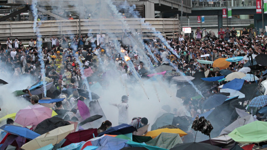
The language of the Earth Kingdom provincial governor echoes statements made by Chinese and Hong Kong pro-Beijing officials alike on the protests. The graffiti on the streets of Yu Dao is directly inspired by graffiti written by HK protesters. Today, many Hong Kong activists remain imprisoned or in exile.
65 notes
·
View notes
Text
Penny Valley Profile: Evelyn Stanier
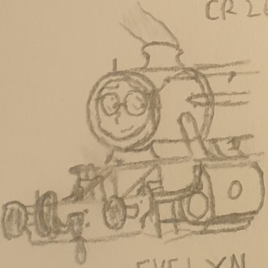
Hi all, just as a quick heads-up, I'll be taking some historical liberties with withdrawal dates, build dates and service careers in these, so sorry rivet-counters. Also, sorry for the shitty artwork, I did it in school :P
Pre-Preservation
Evelyn is a London, Midland and Scottish Railway 8F locomotive built in 1942. Upon her completion, she was immediately requisitioned for use by the Royal Engineers in hauling trains in North Africa. When returned in 1945, she was repainted and allocated to Barrow Hill depot where she'd serve diligently until her withdrawal in 1964.
Preservation
In 1970, Mr. Luke and Mr. Hughes found Evelyn rusting away in a siding near Newton Abbot, where she had supposedly been forgotten about. She was quickly snapped up by the pair and hauled by road to Rattery Engine Works. There, they stripped her down to nuts and bolts and reassembled her from the ground up, refurbishing what they could and replacing what they couldn't. When she returned to traffic in 1976, she was very eager to work. During her trials though, it was found that she was near-sighted to the point it was a miracle she hadn't caused a major accident. Rattery works quickly fabricated a pair of glasses for her use and she's been a loyal worker ever since.
Personality/Characteristics
Evelyn, despite her size and strength, is a very shy engine. She struggles with basic interactions with anyone she doesn't know, often mulls on awkward moments and sometimes even sweats during conversations. The one remedy to this is Luna. Her and Luna are quite possibly the closest friends on the line, with some speculating it could be even more. Luna's feistiness and stubbornness balances out with Evelyn's shyness and generally being something of a doormat. Even though she lets people walk all over her, she tries her best to be a good friend to Luna and the others.
Closing
All in all, Evelyn is an engine that works best when not in the spotlight, preferring (and sometimes needing) to take a backseat role to do a good job.
Thank you all for reading and I hope to see you in the next one.
Cheerio!
6 notes
·
View notes
Text
The Mithril Archipelago, more colloquially known as the Pious Pools, refers to a cluster of islands to the southwest of Tetrahex an orn and some groon out from the shore. When seen from above, the island chain appears to form a large hand rising from the sea, with the ‘palm’ being the largest of eight.
Despite being collectively referred to as the Pious Pools, the most notable tide pools are largely clustered on the eastern side of the palm, index, and middle islands, while the largest natural springs are located on the thumb.
All of the islands in the archipelago are quite rocky, but the hotspot at the base of the thumb has historically produced a notable number of amphibious mecha and triple-changers with alt modes suitable for both the cliffside environment and the warm Mithril Sea.
Most locals live in the center and southeast portions of the palm closest to the thumb, though there are smaller fishing and tourism based areas on the index, middle, and ring fingers. The Pious Pools are well-known for the peculiar traditional architecture of the area, which comes from a mix of the islands originally being settled as a hermitage and simple practicality; most buildings and residences are tucked inside and built out of the natural caves formed by sea erosion over millions of years, or otherwise secured into the sheer cliffs in tiers!
If you wish to visit the ruins of the hermitage, the Little Temple (also known as the Conduit or the First Temple,) please be aware that there is an active and ongoing restoration project underway to restore the damage that occurred under the Functionist Mandate of Singularity. There is a priest in residence and dormitory space available to those devoted or simply curious. Liturgical services are held every orn at 08.45j and end of decacyle services at 17.15j/18.15j depending on the season.
The Iaconian Academy of Science and Medicine has recently reestablished the historical outreach campus of the Grand Archives in the curve between the middle and ring fingers with the help of Deltaran Hospital and Optimus Prime, who has taken up semi-permanent residence on the islands to assist with preservation and archeological efforts.
The tips of the index and middle fingers are recognized by Primal Authority as a preservation site and mechanimal sanctuary. Permits are required for hunting and fishing in the area.
The two islands that make up the smallest finger are generally considered to be uninhabitable, as the middle island and the spit of land that bridges it to the palm is flooded each day at high tide, and the last of the two has recently become the source of a great many strange sightings and ghost stories. Visitors are highly discouraged from lingering.
8 notes
·
View notes
Text
Preserving New York's Past: The Importance of Historic Preservation and Restoration Services in NYC
Preserving the rich history and heritage of New York City is an essential part of maintaining its unique character and charm. From the iconic brownstones of Brooklyn to the towering skyscrapers of Manhattan, the city is home to a wealth of historic buildings that tell the story of its past.
However, preserving these historic buildings is not just a matter of maintaining their physical appearance. It requires a deep understanding of their historical significance, the materials and techniques used in their construction, and the challenges that come with maintaining them in a modern urban environment.
That's where historic preservation and restoration services come in. These specialized services are designed to help property owners and managers preserve the historic character and integrity of their buildings while also ensuring they meet modern safety and building code requirements.
Historic preservation services in NYC typically involve a thorough assessment of a building's historical significance and condition. This may include researching its history, analyzing its architecture and design features, and identifying any areas of deterioration or damage. Based on this assessment, preservation professionals will develop a comprehensive plan for restoring and maintaining the building's historic character while also addressing any necessary repairs or upgrades.
Historic restoration services in NYC, on the other hand, are focused specifically on restoring buildings that have suffered significant damage or deterioration. This may include repairing or replacing damaged materials, restoring historic features and finishes, and ensuring that the building meets current building codes and safety standards.
Restoration of historic buildings in NYC requires a high degree of expertise and specialized knowledge. Historic buildings often require specialized materials and techniques that may not be used in modern construction. Preservation professionals must also navigate a complex web of regulatory requirements and approvals to ensure that the restoration work meets all relevant standards and guidelines.
Overall, historic preservation and restoration services are critical for maintaining the unique character and charm of New York City's historic buildings. Whether you are a property owner, manager, or preservation enthusiast, these services can help ensure that these important landmarks are preserved for future generations to enjoy.
Contact us at 212-279-0000 today or Use our quote form to submit all details of your project. Get your Free Estimate - https://nycerny.com/quote/
#historic building preservation services#restoration of historic buildings in nyc#structural engineering design services#architects and building designer#architects and building designer in nyc#architecture building design#structural engineer#structural engineering#architectural design firm in nyc#building structural engineering services#best structural design engineering firm in nyc#building design#historic preservation services#historic preservation services in nyc#historic preservation and restoration#historic restoration services in nyc#facade restoration nyc#facade repair and maintenance services#exterior facade repair and restoration#facade restoration company nyc#facade restoration services in nyc#structural engineering design firm#structural engineering and architectural design firm#architectural design firm#architectural design
3 notes
·
View notes
Text
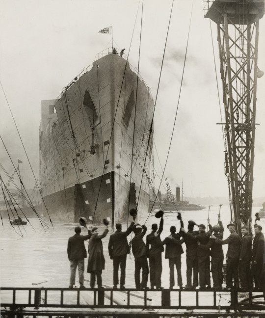

On September 26th 1934 the Liner Queen Mary launched at John Brown’s shipyard, Clydebank.
The construction of still the unnamed Cunard Queen Mary ship began in December 1930 (the ship’s keel was laid down on 31 January 1931) in the yard of “John Brown & Co” at Clydebank. The launch was scheduled for May 1932, but the work on the ship was suspended in December 1931 due to the world economic depression. A loan of 9.5 million pounds from the Government was granted to the Cunard Line with enough money to complete the Queen Mary ship and to build a second liner – the Queen Elizabeth.
As a direct result of this most advantageous deal, the Cunard Line merged with its main rival White Star on 10th May 1934 into Cunard White Star Ltd. The Queen Mary construction resumed in April 1934, the liner was completed by August and launched on 26th September at a total cost of 3.5 million pounds sterling.
The work was completed in March 1936. The Queen Mary ship sailed out for preliminary trials and after being painted in Southampton, the liner was handed over to Cunard White Star Line on 11th May 1936. RMS Queen Mary ship first sailing was on 14th May with its Transatlantic itinerary being Southampton-Cherbourg-New York. By May 1937 the liner had carried a total of almost 57,000 passengers.
The main speed-rival of the QM ship was SS Normandie – a liner built in France and operated by the French Compagnie Generale Transatlantique line. The Queen Mary took the Blue Riband (the prestigious award given to a ship with the speed record for a transatlantic crossing) from the French liner SS Normandie in August 1938, with record speeds for both west- and eastbound crossings of the Atlantic Ocean – the average speeds was, respectively, 30,63 kn (35m25 mph, 56,7 km/h) and 30,14 kn (34,68 mph, 55,82 km/h).
In 1937, the Normandie liner was refitted with new propellers, enabling her to take the Blue Riband, but in 1938 the Queen Mary ship reclaim the honour for best speeds in both directions – westbound 30,99 kn (35,66 mph, 57.39 km/h) and eastbound 31,69 kn (36,47 mph, 58.69 km/h). This record was beaten by the SS United Sates liner in 1952.
The last commercial sailing of the ship Queen Mary was on 30 August 1939 departing from Southampton and then berthed at New York until the end of 1939. With the outbreak of the Second World War, she was converted into a troopship and ferried Allied soldiers for the duration of the war.
Following the war, Queen Mary was refitted for passenger service and along with Queen Elizabeth commenced the two-ship transatlantic passenger service for which the two ships were initially built. The two ships dominated the transatlantic passenger transportation market until the dawn of the jet age in the late 1950s. By the mid-1960s, Queen Mary was ageing and, though still among the most popular transatlantic liners, was operating at a loss.
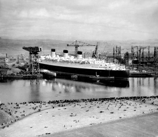
After several years of decreased profits for Cunard Line, Queen Mary was officially retired from service in 1967. She left Southampton for the last time on 31 October 1967 and sailed to the port of Long Beach, California, United States, where she remains permanently moored. Much of the machinery, including one of the two engine rooms, three of the four propellers, and all of the boilers, were removed. The ship serves as a tourist attraction featuring restaurants, a museum and a hotel. The ship is listed on the National Register of Historic Places. The National Trust for Historic Preservation has accepted the Queen Mary as part of the Historic Hotels of America.
RMS Queen Mary remains in Long Beach but recently it has been reported it is in need of significant repairs according to assessments and photos in 2019 and 2020. An estimated $289 million in repairs are needed after years of decline and the most recent operator going bankrupt.But even to “retire and recycle” the liner could cost up to $190m. One of the suggestions are to dismantle and sink the liner, although no long term plans have been finalised as yet.
The Queen Mary is due to open again to visitors next month, let’s hope someone can come up with a rescue plan to save her.
It has been mooted that it could return to the Clyde but the eyewatering amount of money it would take surely rules this out.
13 notes
·
View notes
Text


.
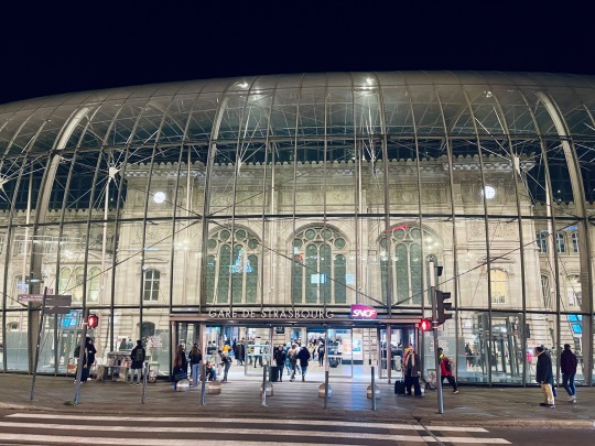
Just wanted to point out the Train Station in Strasbourg because I think it’s a beautiful building mixing the old and the new, or how to extended a building while preserving its original beauty.
Inaugurated in 1883 by the German administration of the time, the station is providing regional, national and international services and is the third busiest station in France (outside the Paris region), behind Lyon-Part-Dieu and Lille-Flandres. A major redevelopment of the station (and its forecourt), marked by the construction of a glass roof in front of the historic façade, was carried out as part of the commissioning of the TGV Est high-speed train in 2007.
7 notes
·
View notes
Text

🇬🇧/🇺🇸:
Meet Ostap, he's a Cossack, which means he's a Ukrainian warrior.
The first mentions of Ukrainian Cossacks appear in historical sources of the 1480s and 1490s.
A Cossack is a free armed individual.
Typically, peasants fleeing from landlords became Cossacks because serfdom existed at that time, and the Ukrainian population, like the Orthodox Church, suffered oppression.
Military and petty nobility also joined the Cossacks, but local residents could also become Cossacks, considering that settlements already existed in the territory where the Cossacks were founded.
The territories where the Cossacks lived were called the Sich.
Essentially, the Sich was the capital of the Zaporozhian Host.
At that time, there were two Cossack states:
The Lower Zaporozhian Host and the Hetmanate, founded by Bohdan Khmelnytsky.
The first known Sich was founded in 1556 on the island of Little Khortytsia by Dmytro Byada-Vyshnevetsky.
Within the territory of the Sich, there was a large Cossack fortress and Cossack settlements.
The main elements of the Sich's territory were:
1. The Sich itself: The central part of the Sich where important administrative and military buildings were located, such as the Council, military barracks, workshops, church, etc. This was also the political and military center of the Cossack state.
2. Cossack settlements: Around the central Sich, there were Cossack settlements or villages where Cossacks and their families lived. They consisted of houses, farms, and some public buildings.
3. Defensive structures: There were defensive structures on the territory of the Sich, such as walls, towers, and various fortifications designed to protect against possible enemy attacks.
4. Military field fortifications: Around the Sich, Cossacks built fortresses and fortifications to protect the territory in case of military conflicts.
5. Trade and craft quarters: The Sich also had trade and craft quarters where Cossacks conducted trade and produced various goods.
The Sich was an important center of the Cossack state, where Cossack identity, military skills, and culture were formed and preserved.
The Cossacks themselves were divided into:
- Registered Cossacks: Registered Cossacks were members of Cossack troops who were officially registered and assigned to a specific Cossack regiment or garrison. Often, such states as the Polish-Lithuanian Commonwealth and the russian empire hired Cossacks for service.
- Lower Cossacks: Lower Cossacks were one of the forms of Cossack organization that emerged in conditions of a large number of free Cossacks not tied to the land. The main difference between lower Cossacks and other forms lay in the fact that these Cossacks did not have their own land plots and were not tied to specific territories; typically, they lived in the territory of the Lower Zaporozhian Host.
- Urban Cossacks: Urban Cossacks were a form of Cossack organization that existed in cities and towns of Ukraine (at that time, the Hetmanate).
They were also known as "garrison Cossacks."
🇺🇦:
Знайомтесь, Остап, він козак, а значить український воїн.
Перші згадки про українських козаків зустрічаються в історичних джерелах 1480-1490-х років.
Козак — вільна озброєна людина.
Як правило, селяни, які втікали від поміщиків, ставали козаками, тому що на той час існувало кріпацтво, а українське населення, як і православна церква, зазнавали утисків.
Козачили також військово службовці та дрібна шляхта, але не можна виключати, що козаками могли бути й місцеві жителі, зважаючи на те, що на території заснування козацтва вже існували поселення.
Території, де жили козаки, називали Січчю. Фактично Січ була столицею Війська Запорізького Низового.
На той час існувало дві козацькі держави : Запорізьке Військо Низове та Гетьманщина, заснована Богданом Хмельницьким.
Першу відому Січ заснував у 1556 році на острові Мала Хортиця Дмитро Байда-Вишневецький.
На території Січі була велика козацька фортеця та козацькі поселення.
Основними елементами території Січі були:
1. Січовий стан: Центральна частина Січі, де розташовувалися важливі адміністративні та військові споруди, такі як Рада, військові казарми, майстерні, церква тощо. Тут також був політичний і військовий центр козацької держави.
2. Козацькі поселення: Навколо центральної Січі були козацькі поселення або села, де жили козаки з родинами. Вони складалися з будинків, ферм і деяких громадських будівель.
3. Оборонні споруди: На території Січі існували оборонні споруди — мури, вежі, різноманітні укріплення, призначені для захисту від можливих нападів ворога.
4. Військово-польові укріплення: Навколо Січі козаки будували фортеці та укріплення для захисту території на випадок військових конфліктів.
5. Торгово-ремісничі квартали: На Січі також були торгово-ремісничі квартали, де козаки вели торгівлю та виробляли різні товари.
Січ була важливим осередком козацької держави, де формувалися й зберігалися козацька самобутність, військова майстерність і культура.
Самі козаки поділялися на:
- Реєстрове козацтво: реєстрові козаки були членами козацького війська, які були офіційно зареєстровані та приписані до певного козацького полку чи гарнізону. Часто такі держави як Річ Посполита та російська імперія наймали козаків на службу.
- Низове козацтво: низове козацтво було однією з форм козацької організації, яка виникла в умовах великої кількості вільного козацтва, не прив'язаного до землі. Основна відмінність низового козацтва від інших форм полягала в тому, що ці козаки не мали власних земельних наділів і не були прив'язані до певних територій; як правило, вони проживали на території Нижнього Запорізького війська.
- Городове козацтво: Міське козацтво було формою козацької організації, яка існувала в містах і містечках України (на той час Гетьманщини).
Їх також називали «гарнізонними козаками».
5 notes
·
View notes
Text
NPS Photo of the Paradise Inn Annex.
On this day in 1966, the National Historic Preservation Act was signed. Under the act, federal agencies like the National Park Service must administer cultural properties “in a spirit of stewardship and trusteeship for future generations…” and “…in such a way that federally owned sites, structures, and objects of historical, architectural or archaeological significance are preserved, restored and maintained for the inspiration and benefit of the people…” This act is only one of several historic preservation laws, regulations, and orders that guide the work of the National Park Service and its partners in local, state, and tribal governments.
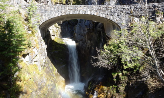
NPS Photos of the Longmire Mineral Spring (left) and Christine Falls (right).
At Mount Rainier National Park, dedicated staff like masons, carpenters, archaeologists, landscape architects, and more contribute to the preservation and maintenance of many historic structures in the park from buildings to bridges. Which historic structures do you enjoy visiting in the park?

NPS Photo of the Sunrise Visitor Center. ~kl
#mount rainier national park#national historic preservation act#historic preservation#historic building#Paradise Inn#Christine Falls#Sunrise Visitor Center#history
64 notes
·
View notes
Last Seen Blogs

bright-eyes-strawberry-lies
🌊 Two Sides Of The Same Coin 🗡️


todayisafridaynight
kill this arrogant mo ther fu cker

micfab
Couple 68

lordsudan
Untitled