#dugout canoe
Text
Up to 11 ancient canoes have been found in Lake Mendota, Madison, the oldest, dating back 4,500 years. With 1, 2 and then more canoes discovered, the lake evolved into a significant archaeological site with much to tell us about the people who lived and thrived in the area over thousands of years.
101 notes
·
View notes
Text
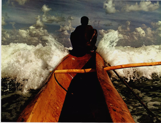
Indian Ocean Mariner - 1981
"Poised at the prow of his dugout canoe, an Indian Ocean mariner faces the challenge of the open sea. From such craft evolved the modern ocean liner."
74 notes
·
View notes
Text

Return from fishing
#dakar senegal#dndaophotography#beach#senegal#sunset#culture#dakar#Ouakam#Fisherman#Cap vert#Boat#Dugout canoes#Africa
2 notes
·
View notes
Text
The Keel
The keel is the most important longitudinal structure of a ship or boat, attached to the floor amidships.
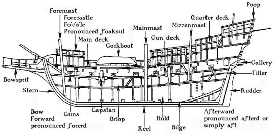
Ship parts
In terms of development history, the keel originated from the dugout canoe. The first further development of the dugouts consisted of inserting frames and raising the sides by adding plank walkways. Once this technique had been perfected, the dugout was gradually reduced in size until it was ultimately only the supporting element, the keel, of the hull. The keel is therefore the "backbone" of the ship. The transverse stabilising frames, the "ribs", are attached to it. At its ends, the keel merges into the stem. In addition to stabilising the hull, it also serves to increase course stability and - especially in sailing vessels - to reduce lateral drift.
Even if the word sounds very strange, it comes from Old English cēol, Old Norse kjóll, = "ship" or "keel". It has the distinction of being regarded by some scholars as the first word in the English language recorded in writing, having been recorded by Gildas in his 6th century Latin work De Excidio et Conquestu Britanniae, under the spelling cyulae (he was referring to the three ships that the Saxons first arrived in).
However, there are also ships that have no keel, such as flat-bottomed ships. This is a sailing ship that was mainly built for use in the mudflats of the North Sea and the English Channel. The two leeboards on the side of the hull and the extremely shallow draught of around one to one and a half metres are characteristic of flat-bottomed ships. They can navigate large parts of the Wadden Sea and coastal regions even at low tide.
#naval history#naval artifacts#parts of a ship#keel#ancient seafaring#medieval seafaring#age of discovery#age of sail#age of steam#modern
178 notes
·
View notes
Text
I’m very curious what type of boat Tolkien was picturing with the elven-boats, because this seems like something ppl will have solved, and I’m particularly curious what Tolkien imagined were historically accurate boats. To me, they sound exactly like canoes — but with broad paddles (better for racing or whitewater than the thinner paddles used for distance) — right down to the “uhhHHH please practice getting in and out of them first” advice from the elves, and the way it’s three to a boat (bow, stern, and center).
There were historical canoes in the European half North Sea as well as the Americas half, but the literature tends to gloss over that. Are they birch bark? Dugout? Not a fucking canoe? Elf boat mystery… 😔😔🛶
56 notes
·
View notes
Text
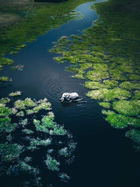
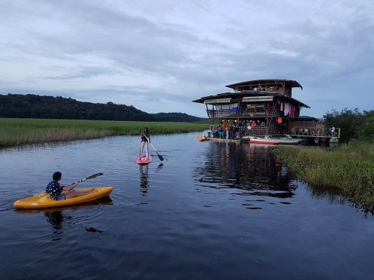
The Okavango Delta is a vast inland river delta in northern Botswana. It's known for its sprawling grassy plains, which flood seasonally, becoming a lush animal habitat. The Moremi Game Reserve occupies the east and central areas of the region. Here, dugout canoes are used to navigate past hippos, elephants and crocodiles. On dry land, wildlife includes lions, leopards, giraffes and rhinos.
Photo 📷 @Solly Levi Photography
69 notes
·
View notes
Text
you guys don’t appreciate how cool it was when your ancestors invented shit. nowadays it happens every two seconds and it’s never anywhere near as game-changing as like, ochre paint or dugout canoes or bone splints or trepanation or spear throwers or cunnilingus or willow bark tea or forest management. what the fuck is a microchip
39 notes
·
View notes
Text
Bloated and distorted carcasses shimmered on the surface of Lake Ambavarano in southeastern Madagascar. Forty-year-old fisherman Olivier Randimbisoa lost count as they floated by.
“I know what it’s like to see a dead fish that’s been speared,” he said. “I’d never seen anything like this.”
A series of cyclones and storms had battered the region in early 2022, and in the days afterward, the air was still and calm. As Randimbisoa paddled around in his dugout canoe, he recognized the different species and called them by their local names: fiambazaha, saroa, vily, and malemiloha. Overnight, the fish he made his living from, the fish his wife and children ate, the fish that supported the entire lakeside community, were nearly gone.
“It was scary, because we have been eating fish from this lake for so long. We have fed our families, and now it’s polluted,” said Randimbisoa. “We have told our families not to go to the lake.”
Randimbisoa has a theory about what killed the fish. “It’s dirty water from the factory of QMM,” he said.
Lake Ambavarano, where Randimbisoa works, is connected to two other lakes — Besaroy and Lanirano — through a series of narrow waterways. The lakes are adjacent to QIT Madagascar Minerals, or QMM: a mine in Madagascar that’s 80 percent owned by the Anglo-Australian mining and metals behemoth Rio Tinto, and 20 percent by the government of Madagascar. The mine extracts ilmenite, a major source of titanium dioxide, which is mainly used as a white pigment in products like paints, plastics, and paper. QMM also produces monazite, a mineral that contains highly sought-after rare-earth elements used to produce the magnets in electric vehicles and wind turbines.
After the fish deaths, the government of Madagascar’s environmental regulator and Rio Tinto conducted water sampling work. Citing such testing, Rio Tinto says there is no proof that its mining killed the fish. Water sample analysis revealed “no conclusive link between our mine activities and the observed dead fish by community members,” a company spokesperson wrote in an email to The Intercept. Those results have not been made available to the public, despite requests by civil society groups and The Intercept.
continue reading
Rio Tinto is the company that destroyed the sacred caves used by Aborigines, the 46,000-year-old Juukan Gorge rock shelters, to mine iron ore.
8 notes
·
View notes
Photo
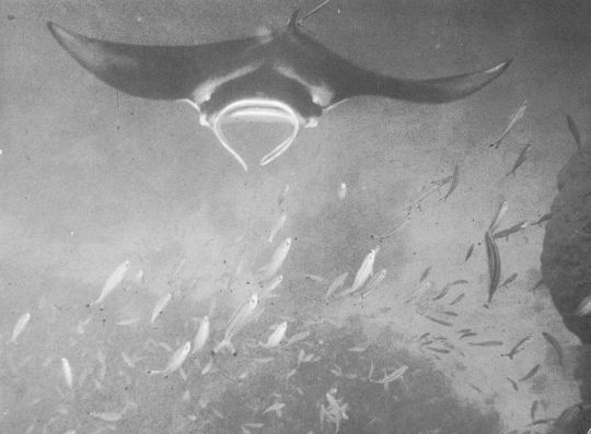
Manta, Polynesia, 1975. "...Because mantas are fish with big wings and they fly like seagulls in the sea, but they are a hundred times bigger than seagulls, they are even as big as dugout canoes. And they never hurt men, on the contrary they bring them good luck. As they sailed, everyone said that the mantas would guide them to the mother-of-pearl banks." From "Fratello Mare" by Folco Quilici. https://www.instagram.com/p/ClUPpJrtvJ4/?igshid=NGJjMDIxMWI=
116 notes
·
View notes
Text
Les Marais De Kaw
Dégrad de Kaw Réserve Naturelle, 97353 French Guiana
Type: Genuine Guyanese Everglades.
Access: via the RN2, 50 km from Roura.
Note that at the end of the road, the village is only accessible by dugout canoe. The presence of a companion is therefore necessary.
Interests: this nature reserve is an exceptional observation site for a large and varied birdlife, and remains the privileged domain of caimans; Accommodation possibilities in a passing carbet located in the village of the village.
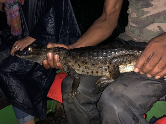
Caiman (a kind of alligator).
Kaw-Roura Marsh
View of the marshesBanks of the Orapu RiverMonkey SaimiriBanks of the Orapu RiverPoison dart frog
Email address to contact the reserve: [email protected] or [email protected]
This reserve has a Facebook page. Find out now!
The nature reserve is home to rare species, endangered and with a very limited geographical distribution, such as the Black Cayman or the Red Ibis, and remarkable and unusual species such as the Hoazin crested (primitive bird) or the Atipa (fish).
Of the 98 mammal species found in the Kaw area, 38 species are noteworthy. 54% of Guyana's protected species are present in the nature reserve, including the Black Cayman, the Manatee, the Giant Otter and the Guyana Otter, jaguars, spider crabs and the Matamata Tortoise.
The Kaw region is exceptionally rich in bird species as it is home to 535 species, or 74% of the avifauna of French Guiana. These include the Cocoi Heron and the Agami Heron, the Great Egret, the Cockerel, the Harpy Eagle and the Great Crested Harpy.
74 species of amphibians and 103 species of reptiles have been inventoried throughout the area. Among these are 4 species of caimans: the Red Cayman, the Grey Cayman, the Spectacled Caiman and the Black Cayman.
The marshes are about 90 minutes from Cayenne and about two and a half hours from Kourou. There is a one hour drive through the jungle on a narrow two lane road that would be classified as one lane in the US. The road does have isolated potholes, blind curves, and on coming traffic, so the drive requires concentration.
This is a beautiful wild nature reserve that is a privilege to visit. In the raining season you can navigate very easily and really see it all. The variety of birds, butterflies is breathtaking.
7 notes
·
View notes
Text
When archaeologists unearthed five dugout canoes at La Marmotta, an Italian archaeological site nestled in the Mediterranean basin, little could they know that they had come across the earliest Neolithic boats found to date.
By conducting extensive research into these ancient remains, they ended up determining that they were actually over 7,000 years old. They were also found to demonstrate the ingenuity of their era, having been built using a technology far more developed than previously understood, revealing hereto unknown insights into Neolithic navigation and boatbuilding culture in the Mediterranean.
22 notes
·
View notes
Text
Half of all U.S. states, 25 to be exact, carry Native American names. Today we will be taking a look at the 14 states and the meanings of their names. They will be listed in alphabetical order.
1. Alabama: Named after the Alabama, or Alibamu tribe, a Muskogean-speaking tribe. Sources are split between the meanings 'clearers of the thicket' or 'herb gatherers'.
2. Alaska: Named after the Aleut word "alaxsxaq", which means "the mainland"
3. Arizona: Named after the O'odham word "alĭ ṣonak", meaning "small spring"
4. Connecticut: Named after the Mohican word "quonehtacut", meaning "place of long tidal river"
5. Hawaii: Is an original word in the Hawaiian language meaning "homeland"
6. Illinois: Named after the Illinois word "illiniwek", meaning "men"
7. Iowa: Named after the Ioway tribe, whose name means "gray snow"
8. Kansas: Named after the Kansa tribe, whose name means "south wind people"
9. Kentucky: Origins are unclear, it may have been named after the Iroquoian word "Kentake", meaning "on the meadow"
10. Massachusetts: Named after the Algonquin word "Massadchu-es-et," meaning "great-hill-small-place,”
11. Michigan: From the Chippewa word "Michigama", meaning "large lake"
12. Minnesota: Named after the Dakota Indian word “Minisota” meaning “white water.”
13. Mississippi: Named after the river which was named by the Choctaw, meaning “Great water” or “Father of Waters.”
14. Missouri: Named after the Missouri tribe whose name means "those who have dugout canoes"
15 notes
·
View notes
Text
The Mysterious Peterborough Petroglyphs

The Peterborough Petroglyphs are the largest collection of ancient rock carvings in all of North America, made up of over 900 images carved into crystalline limestone located near Peterborough in Ontario, Canada.
Designated a National Historic Site of Canada in 1976, local indigenous people believe that this is an entrance into the spirit world and that the Spirits actually speak to them from this location. They call it Kinoomaagewaapkong, which translates to "the rocks that teach."
The petroglyphs are carved into a single slab of crystalline limestone which is 55 metres long and 30 metres wide. About 300 of the images are decipherable shapes, including animals, humans, shamans, solar symbols, geometric shapes and boats.
It is generally believed that the indigenous Algonkian people carved the petroglyphs between 900 and 1400 AD. But rock art is usually impossible to date accurately for lack of any carbon material and dating artfiacts or relics found in proximity to the site only reveals information about the last people to be there. They could be thousands of years older than experts allow, if only because the extensive weathering of some of the glyphs implies more than 1,000 years of exposure.
There are some other mysteries surrounding these remarkable petroglyphs. The boat carvings bear little resemblance to the traditional boat of the Native Americans. One solar boat -- a stylized shaman vessel with a long mast surmounted by the sun -- is typical of petroglyphs found in northern Russia and Scandanavia. A Harvard professor believes the petroglyphs are inscriptions (and maybe even a form of written language) left by a Norse king named Woden-lithi, who was believed to have sailed from Norway down the St. Lawrence River in about 1700 B.C., long before the Greenland Viking explorations.
Another vessel depicted in the petroglyphs is a large ship with banks of oars and figure-heads at bow and stern. There is a large steering oar at the stern, a necessary feature only for vessels that are 100 feet or more in length. However, the Algonkian people who inhabited the region never built anything more seaworthy than a birch-bark canoe or a dugout. Even reluctant archaeologists admit that the ships "do not look like real Algonkian canoes" but steer away from any controversial conclusions about pre-Columbian visitors by speculating that the vessels are simply a shaman's idea of magical canoes that travel the universe.
Another peculiarity is the figure-heads at bow and stern which resemble birds. The same design can be seen in Etruscan repousse gold work of the 9th century BC. The bird-headed ships were portrayed 200 years earlier, when Egyptian artists carved their images into the walls of Pharaoh Ramses IIIs "Victory Temple" in the Valley of the Kings.
Yet another mystery is the presence in the petroglyphs of a tall figure or 'god' which stands with arms akimbo and with a halo radiating rays, presumably from the sun. Cowering before him are two minute humble humans in attitudes of supplication. Scientists think the figure may represent a sun god but there doesn't exist any known cases of sun worship among the indigenous people of the region.
Some historians and researchers believe there is more to the petroglyphs than meets the eye. Some maintain that they are in fact a sky map of the heavens based on European tradition from 3100 BC. Evidence includes four signs which are the same as those found for the identical astronomical position at Lewes, England, leading to a possible speculative connection between the Peterborough petroglyphs and the megalithic people of Ancient Britain.
So the petroglyphs of Peterborough remain an intriguing riddle, a sort of code to which the key is still missing.
14 notes
·
View notes
Text
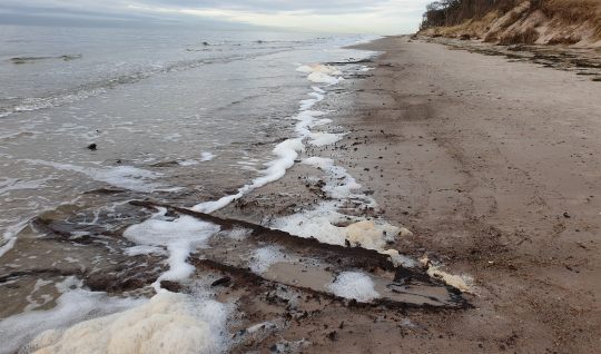
On the Baltic Sea beach on the Darß in Mecklenburg-Western Pomerania, visitors made a rather unusual discovery in the spring of 2022. A dugout canoe was found there, and to prevent it from falling apart on the spot, it was salvaged and examined, including a dendrochronological examination of the wood to find out its age. Until these results are available, the dugout is lying in water. It is not yet possible to say from what period it originated.
78 notes
·
View notes
Text
The world’s oldest boat dates back around 10,000 years. Discovered in 1955 in the Netherlands, the dugout canoe – known as the Pesse canoe – was crafted by axe from a Scot’s pine. Stretching back further in time, the first established boat travel is argued to be around 50,000 years ago, when Homo sapiens set forth from the mainland of Asia to colonize places such as New Guinea and Australia.
Some researchers, however, argue that sailing is not the sole domain of Homo sapiens, but our earlier relatives. Yet, in the absence of any other boats, much of the evidence for earlier seafaring remains indirect, says Bruce Hardy, chair of the Department of Anthropology at Kenyon College.
“Most of it has to do with the fact that you have human occupation on islands that were never connected by land anywhere, at any point, even when we have lower sea levels,” Hardy says. “You either have to postulate that you've got natural rafts drifting and leading to human occupation of some of these islands or you've got to have an intentional movement to the islands, which is going to have to involve some kind of watercraft.”
2 notes
·
View notes
Text

This dugout canoe was found on the banks of the Red River! It dates to the 14th Century! At 34 feet in length, it is the largest Native American canoe ever discovered in Louisiana!
Larto Lake is connected to the Red River through Big Larto Bayou, which is where the dam is located. One can just imagine Native Americans paddling on Larto Lake and the surrounding streams in such a dugout canoe! These water bodies served as liquid highways!
There certainly were plenty of cypress trees around to use as building material. The cypress wood was impervious to insects and rot, as evidenced by this canoe which is over 700 years old!
By Trevor Fry
116 notes
·
View notes
Last Seen Blogs

righteo-paul-jones
Righteo

barrenceallence
he's just a nerd.

attunedadventures
arcane ascension

khaoulamez
خولة

maplemachiato
C O Z Y