#The Karakoram Highway
Text

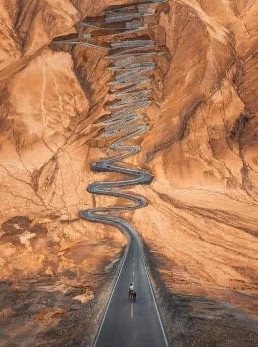
The Karakoram Highway, connecting Pakistan to China, is one of the highest paved roads in the world, at maximum elevation of 4,714 m.
It is often referred to as the Eighth Wonder of the World.
More details/photos :: David Attenborough fans
* * * *
“Everything belonged to him. It made me hold my breath in expectation of hearing the wilderness burst into prodigious peal of laughter that would shake the fixed stars in their places.”
― Joseph Conrad, Heart of Darkness
#High Places#David Attenborough#Eighth Wonder of the World#The Karakoram Highway#Pakistan#China#wilderness#mountain#s quotes#Joseph Conrad#Heart of Darkness
15 notes
·
View notes
Text
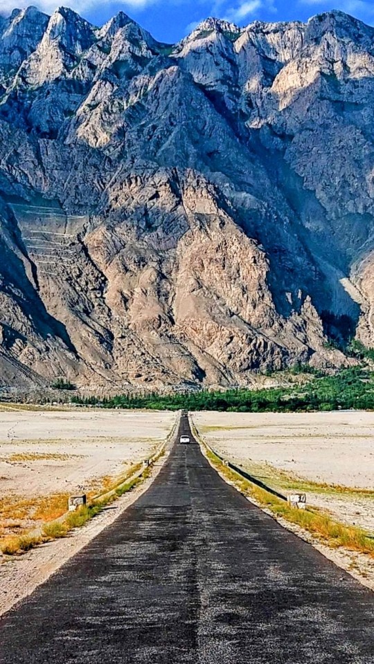
Karakoram Highway, N-35, Pakistan
Shakeel Ahmad
2 notes
·
View notes
Text


Pakistan 🇵🇰 Famous Passu cones, Karakoram highway, Northern Pakistan...Ünlü Passu Koniler, Karakurum Karayolu, Kuzey Pakistan...
#pakistan#manzara#doğa#natural#montain#travel destinations#travel photography#gezi#doğa yürüyüşü#entehlikeli yollar#yol#balistan#gilgit baltistan#gilgit#hunza#himalayan#himalaya dağları#Hunza River#passucones#karakoram highway#northern pakistan#karakurum#karakurum karayolu#kuzey pakistan
66 notes
·
View notes
Text
Gilgit Baltistan, Pakistan - The Jewel Of Pakistan
Exploring the Jewel of Pakistan – Gilgit Baltistan
Gilgit Baltistan, often referred to as the Jewel of Pakistan, unfolds its natural beauty and cultural richness to travellers. Nestled in the heart of the Himalayas, this region is a paradise for nature enthusiasts and adventure seekers. Join us on a journey to discover the unparalleled charm of Gilgit Baltistan and explore the top 10 must-do…

View On WordPress
#Attabad Lake#Baltit Fort#Deosai National Park#Fairy Meadows#Gilgit Baltistan#Hunza Valley#Karakoram Highway#Khunjerab Pass#local cuisine.#local festival#Pakistan#Shangrila Resort#Travel
0 notes
Text
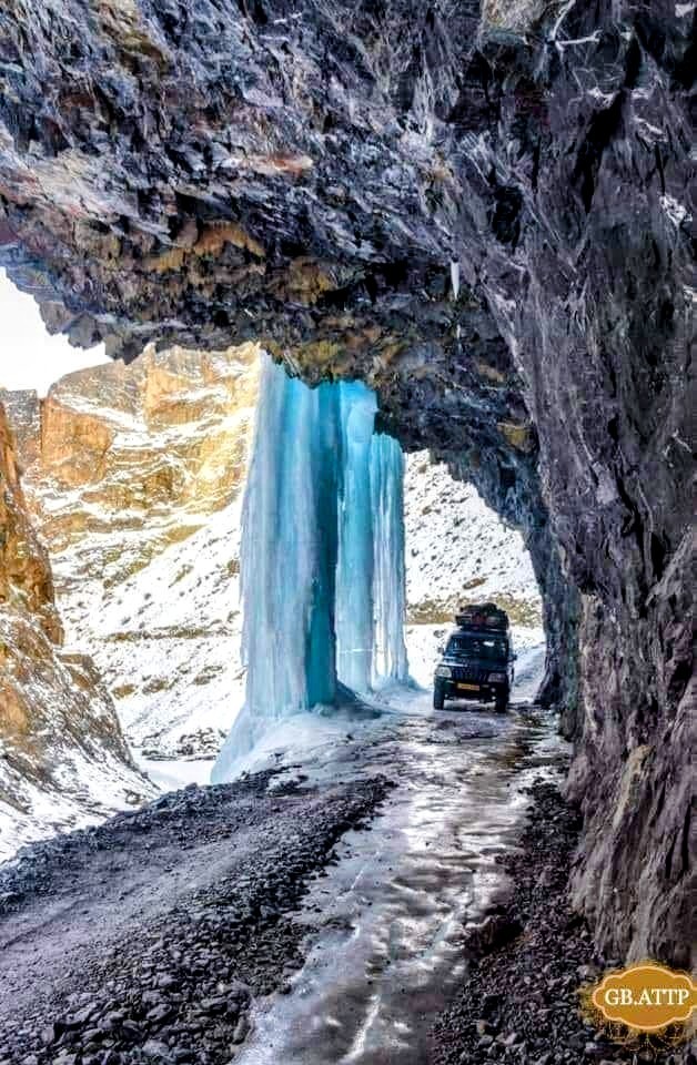
Naltar 2017 - Into the Frozen Land
In February 2017, I set out on a road trip via the Karakoram Highway (KKH) to Naltar valley along with a group of 12 ski enthusiasts for the first skiing experience of my life. This travelogue is the summary of some 170 GB content containing images and video clips that I brought back home from the trip.
Enjoy and don’t forget to subscribe to my Youtube channel; I’ve got more videos coming.
youtube
View On WordPress
#Discover Pakistan#Karakoram Highway#KKH#Naltar#Naltar 2017#Naltar Road#Naltar Ski Resort#Naltar Valley#Pakistan#Skiing#Skiing in Naltar#Spectacular Pakistan#Wonderful Pakistan#Youtube
0 notes
Text
شاہراہِ قراقرم جو پاکستان اور چین کے درمیان پل بن گئی

مجھے شاہراہِ قراقرم پر 25 بار سفر کا تجربہ ہے اور میں اس سٹیٹ آف دی آرٹ شاہراہ کے اطراف میں پھیلے مناظر اور مشکل ترین سفر کے آسان احساس کا شاہد ہوں۔ دریائے سندھ کے ساتھ ساتھ بل کھاتی قراقرم ہائی وے کبھی جگلوٹ تک ویران تھی اور اب تو ہر طرف آباد ہو چکے قصبے ہیں جہاں ضروریات زندگی کی تمام اشیا کی دستیابی کے ساتھ ساتھ اے ٹی ایم اور پٹرول پمپس بھی کھل چکے ہیں۔ پاکستان میں 1956 سے 1958 تک تعینات رہنے والے چین کے سفیر جنرل چینگ بائیو نے چین کو گلگت سے ملانے کی خواہش کا پہلی بار اظہار کیا تھا۔ 1963 میں دونوں ممالک کے درمیان اعلیٰ سطح کی بات چیت ہوئی اور پھر 1966 میں اس اہم سڑک کی تعمیر کا آغاز ہوا۔ قراقرم کی تعمیر میں پاکستان اور چین کے 25 ہزار مزدوروں اور کارکنوں نے حصہ لیا تھا۔ اس وقت کم وسائل اور محدود مشینری کے باوجود سنگلاخ چٹانوں کو کاٹ کر ہموار راستہ بنانا ایک ناممکن کام تھا اور حویلیاں سے خنجراب تک لگ بھگ چار سو کلومیٹر کی اس سڑک کی تعمیر کے مشکل ترین کام کے دوران 408 کارکن مارے بھی گئے تھے۔ گویا لگ بھگ سڑک کے ہر کلومیٹر نے ایک جان کا نذرانہ قبول کیا۔

لیکن یہ سڑک خنجراب پر ختم نہیں ہو جاتی، اس سے آگے چین کے وسیع و عریض صوبے سنکیانگ میں رواں دواں رہتی ہے۔ یہ شاہراہ بننے سے پہلے گلگت، سکردو اور ہنزہ جانا خواب و خیال کی طرح تھا۔ سفر دنوں میں نہیں، ہفتوں کی بات تھا۔ یہ علاقے بےحد پسماندہ اور مرکزی دھارے سے یکسر کٹے ہوئے تھے۔ نہ وہاں کے باسیوں کو بقیہ پاکستان کی کوئی خبر تھی، نہ بقیہ پاکستان کو وہاں کی کوئی اطلاع۔ سڑک نے بقیہ پاکستان کو شمالی علاقوں سے ملانے کے لیے ایک پل کا سا کام کیا۔ اب لوگ گھنٹوں میں اسلام آباد سے گلگت پہنچنے لگے۔ خنجراب پاس سے چلاس تک کے علاقے سیاحوں کو اپنی طرف بلانے لگے اور پھر نانگا پربت، فیری میڈوز، تین پہاڑی سلسلوں کا ملاپ، راکا پوشی اور شمشال جیسے خوبصورت نظارے عام آدمی کو میسر آئے۔ اس سڑک کے بننے سے ان علاقوں میں ترقی و خوشحالی کا ایسا دور شروع ہوا جس سے شرح خواندگی 14 فی صد سے 60 فیصد تک جا پہنچی۔ خواتین میں شرح خواندگی بھی تسلی بخش رہی۔ ہنزہ، سوست، نگر اور غذر کے لوگ اب دنیا بھر میں پاکستان کی روشن مثال ہیں۔
شاہراہِ قراقرم کے وہ حصے جہاں لینڈ سلائیڈنگ کی وجہ سے رکاوٹیں آتی تھیں اور چین سے پاکستان تجارتی سامان لانے والی گاڑیاں کئی کئی دن رکی رہتی تھیں، اب وہاں سرنگیں بنا دی گئی ہیں جن کی لمبائی دو سے 10 کلومیٹر تک ہے، جس کی وجہ سے اب شاہراہ سال بھر کھلی رہتی ہے۔ اس ایک سڑک کی تعمیر نے خطے کو معاشی طور پر مضبوط کر دیا ہے۔ یہی نہیں، بلکہ کہا جا سکتا ہے کہ چین پاکستان راہداری جیسے عظیم الشان منصوبے دراصل شاہراہِ قراقرم کی ہی توسیع ہیں۔ اس سڑک کا صرف پاکستان ہی کو نہیں، چین کو بھی بے پناہ فائدہ ہوا ہے۔ مشرقی چین تو زمانۂ قدیم ہی سے ایک ترقی یافتہ ملک رہا ہے، مگر اس کے مغربی علاقے خاص طور پر سنکیانگ جیسا دور افتادہ صوبہ پسماندہ اور بقیہ دنیا سے تقریباً کٹا ہوا تھا۔ اس شاہراہ نے ان مغربی علاقوں کو بقیہ دنیا سے ملایا۔
چونکہ چین 60 کی دہائی سے قبل بقیہ دنیا سے الگ تھلگ تھا، اس لیے چینی مسلمان حج و عمرہ کرنے کی حسرت دل میں لیے دنیا سے رخصت ہو جاتے تھے۔شاہراہِ قراقرم بننے کے بعد چین کے لوگ گلگت سے ہوتے ہوئے اسلام آباد پہنچنے لگے اور یہاں سے عازمِ حج ہونے لگے۔ لوگوں کو یاد ہو گا کہ اسلام آباد میں واقع حاجی کیمپ میں چینی مسلمانوں کے لیے الگ سیکشن بنایا جاتا تھا۔ اسلام آباد کی اسلامک یونیورسٹی میں آج بھی چینی طلبہ و طالبات کی بڑی تعداد دینی علوم حاصل کرتی ہے۔
قیصر عباس صابر
بشکریہ انڈپینڈنٹ اردو
1 note
·
View note
Text

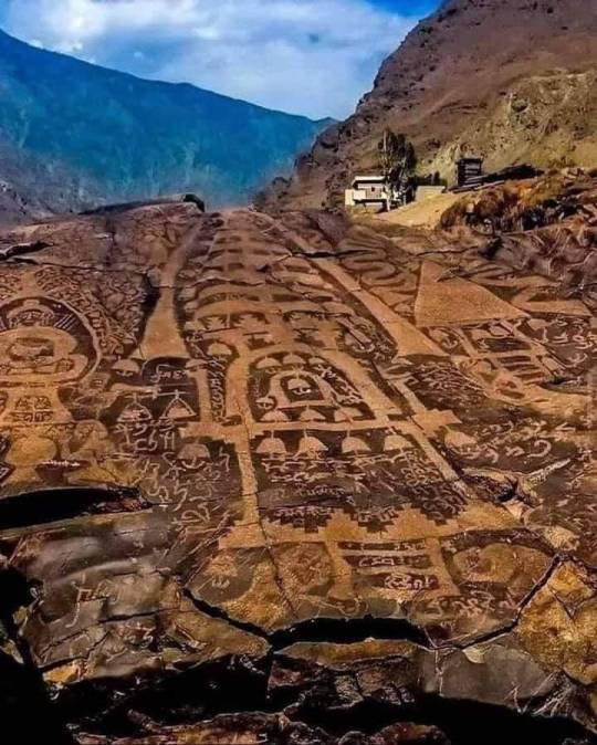
In the elevated Indus Valley of Pakistan, you'll find some of the world's most intricate and diverse petroglyphs. Specifically, the ancient Shatial glyphs along the Karakoram Highway in the Gilgit-Baltistan region stand out. Dating back to the Stone Age, these glyphs adorn rocks and boulders, extending for over 100 kilometers. Encompassing various languages, religions, and the symbolism of peoples spanning 10,000 years, these remarkable writings and designs face potential threats from modern hydropower projects planned in the Indus Valley.
507 notes
·
View notes
Photo
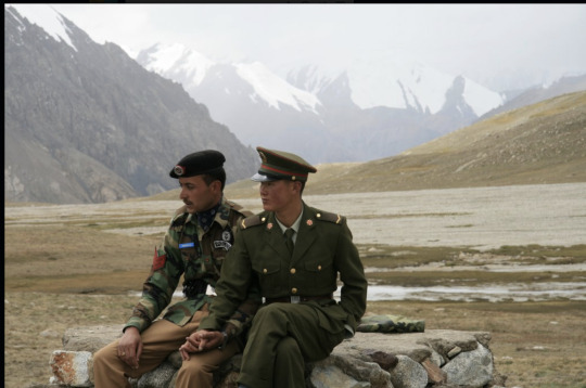
Chinese and Pakistan border guards at Karakoram Highway
219 notes
·
View notes
Text

"In the elevated Indus Valley of Pakistan, you'll find some of the world's most intricate and diverse petroglyphs. Specifically, the ancient Shatial glyphs along the Karakoram Highway in the Gilgit-Baltistan region stand out. Dating back to the Stone Age, these glyphs adorn rocks and boulders, extending for over 100 kilometers. Encompassing various languages, religions, and the symbolism of peoples spanning 10,000 years, these remarkable writings and designs face potential threats from modern hydropower projects planned in the Indus Valley."
35 notes
·
View notes
Text

High up in Pakistan's Indus Valley are some of the most intricate and diverse petroglyphs on earth. These are the ancient Shatial glyphs on the Karakoram Highway in the Gilgit-Baltistan region. Dating from the Stone Age to the birth of Islam, the glyphs cover boulders and boulders stretching for more than 100 kilometers. The writings and designs cover various languages, religions and the symbolism of peoples dating back 10,000 years.
[Historical Images]
* * * *
“You walk towards the edge of knowledge, and then you walk down the vertical plateau of curiosity.”
— Ahmed Salman (via inthenoosphere)
85 notes
·
View notes
Text

📷 Cecilia Kokai
Karakoram Highway connecting Pakistan to China. Known to the Chinese as the "Road of Friendship", this highway connects Pakistan to China through the Karakoram Ridge. Crosses the Khunjerab Pass at an altitude of 4,964 meters (second highest in the world). Its construction began in 1959 and it was completed after 27 years. The Karakoram is an incredible feat of engineering, spanning 1,300 km across three mountain ranges of the Himalayas and the Hindukush.
15 notes
·
View notes
Text
Karakoram Highway connecting Pakistan to China
Known as the "Friendship Road" by the Chinese, this highway connects Pakistan to China through the Karacorum ridge. Cross the Khunjerab Pass at an altitude of 4,964 meters (second highest in the world).
Its construction was given in 1959 and it was completed after 27 years of construction. Karakoram is an incredible feat of engineering, stretching 1300 kilometers across three mountain ranges in the Himalayas and Hindukush.
3 notes
·
View notes
Text
Indus Valley of Pakistan 🇵🇰
High up in Pakistan's Indus Valley are some of the most intricate and diverse petroglyphs on earth. These are the ancient Shatial glyphs on the Karakoram Highway in the Gilgit-Baltistan region. Dating from the Stone Age to the birth of Islam, the glyphs cover boulders and boulders stretching for more than 100 kilometers. The writings and designs cover various languages, religions and the symbolism of peoples dating back 10,000 years.
Historical Images
Karina Sudarsky
5 notes
·
View notes
Text
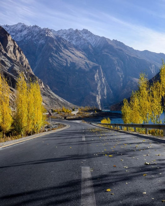
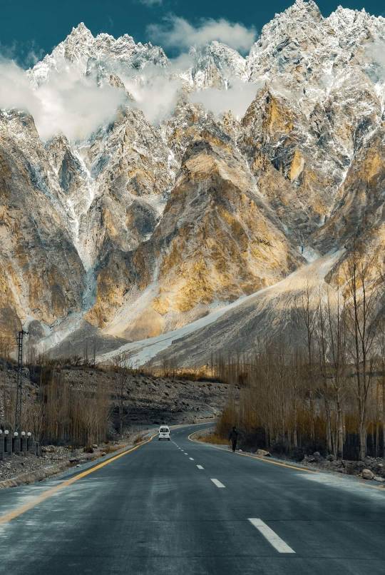
Golden hour on Karakoram highway
Follow adiltaaj on Insta
15 notes
·
View notes
Text
The Karakoram Highway, connecting Pakistan to China, is one of the highest paved roads in the world, at maximum elevation of 4,714 m.
It is often referred to as the Eighth Wonder of the World.
0 notes
Text

Sithara Hansani
Karakoram Highway connecting Pakistan to China
Known as the "Friendship Road" by the Chinese this highway connects Pakistan to China through the Karacorum ridge. Cross the Khunjerab Pass at an altitude of 4,964 meters (second highest in
the world) Its construction was given in 1959 and it was completed after 27 years of construction Karakoram is an incredible feat of engineering,
stretching 1300 kilometers across three
mountain ranges in the Himalayas and
Hindukush.
191 notes
·
View notes
Last Seen Blogs

denisse-sannr
Hic et nunc

haemosexuality
is it like sleeping? quieter?


elamodelcollar
El Amo del Collar

misfitsoul
Get the f*** out of my show right now!