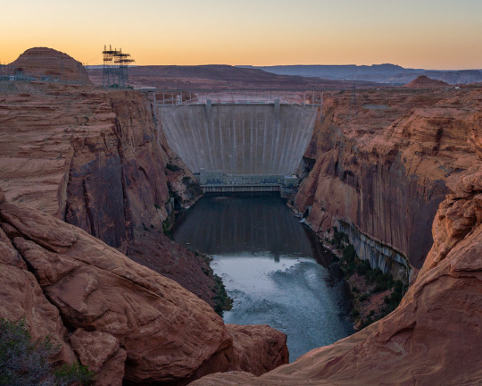
#Glen Canyon Dam Overlook
Text

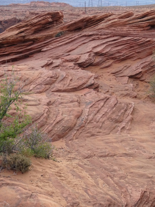
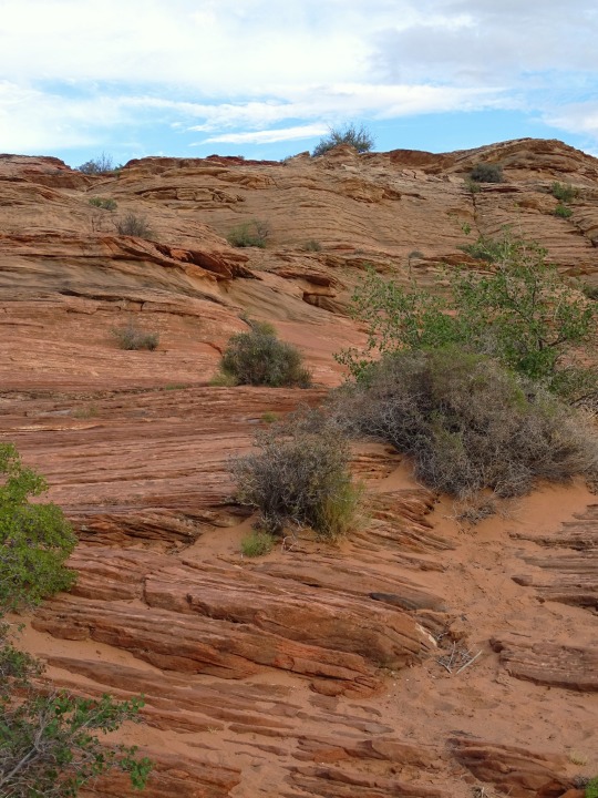


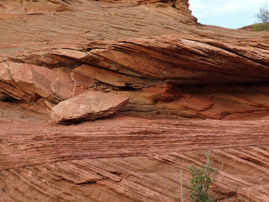

Glen Canyon National Recreation Area, AZ (No. 9)
Dam Overlook Trailhead
This very short walk takes you to a viewpoint on the canyon rim high above the Colorado River. It affords an unparalleled view of the river, the canyon, and Glen Canyon Dam. This scenic view provides spectacular vistas of the Colorado River as it flows through Glen Canyon and of Glen Canyon Dam itself. From the parking area, follow the metal handrail down the uneven rock steps.
Trailhead: From U.S. Hwy. 89, turn west on Scenic View Drive, 1.5 miles (2.4 km) south of Carl Hayden Visitor Center. Take the first road to the right, and park in the parking area at the end of the road. (You may also access Scenic View Drive just south of the Park Headquarters building.)
Source
#Glen Canyon Dam Overlook#Glen Canyon National Recreation Area#Glen Canyon NRA#GCNRA#Coconino County#Southwestern USA#Colorado Plateau#desert#flora#nature#blue sky#clouds#grass#travel#original photography#vacation#tourist attraction#landmark#landscape#countryside#USA#Arizona#summer 2022#red rock#Page#engineering#technology#Colorado River#detail#close up
32 notes
·
View notes
Photo
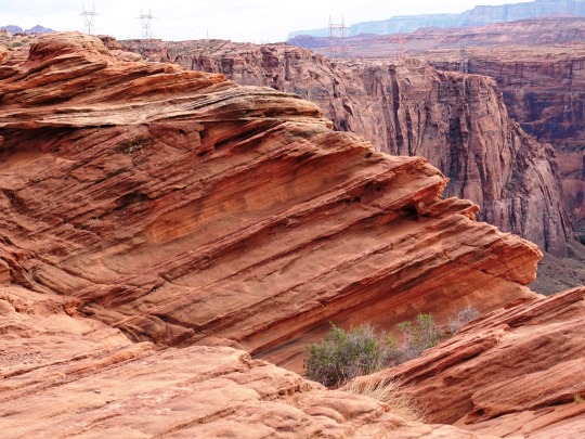
Glen Canyon Overlook, Page Arizona
#Glen Canyon Overlook#Glen Canyon Dam#Page#Arizona#Scenery#Landscape#Nature#Trailhead#Colorado river#Scenic view
45 notes
·
View notes
Text


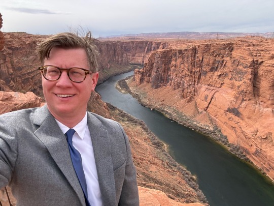
Had a great time working near Horseshoe Bend, Glen Canyon Dam, and in Page, Arizona this week!
#ericruchensky#eric ruchensky#arizona#flagstaff#hiking#lawyer#attorney#coconino county#clouds#horseshoe overlook#horseshoe bend#glen canyon dam#page#pageaz#opt outside#desert#lake powell#lake#lakeside#lake life
2 notes
·
View notes
Video
Overlook by James Marvin Phelps
Via Flickr:
Overlook Glen Canyon Dam Page, Arizona
#arizona#page arizona#dam#glen canyon dam#glen canyon#colorado river#lake powell#usa#southwest#drought#water#glen canyon dam bridge#james marvin phelps photography#hydroelectric#power#flickr
4 notes
·
View notes
Text

Short walk down but not an easy walk for a one-armed man.
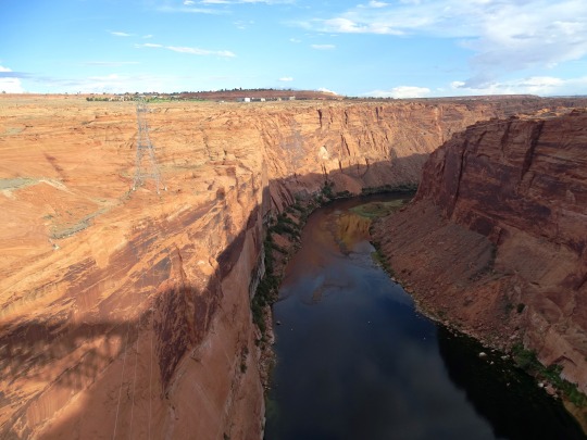
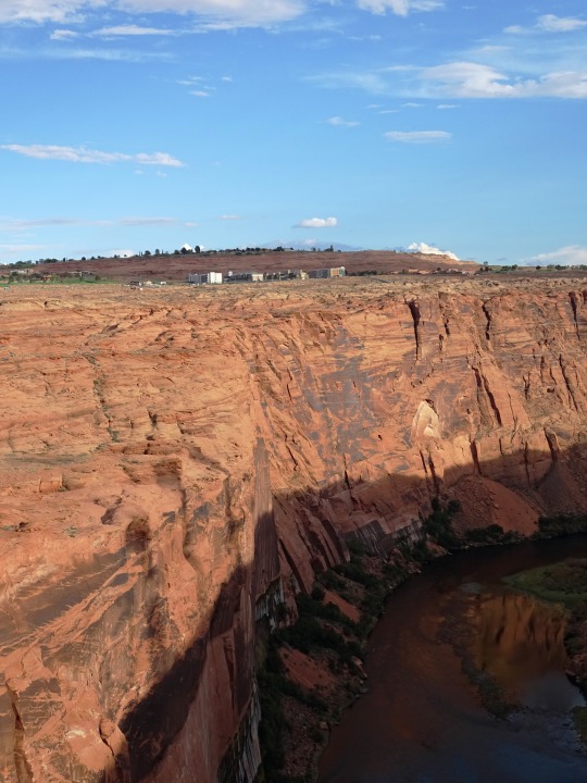
View of the Glen Canyon Dam and the Colorado River from the Glen Canyon Dam Overlook, Page, AZ
1 note
·
View note
Photo

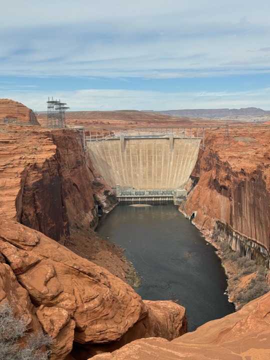
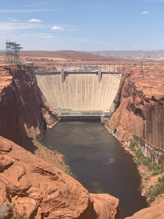
Here's where we ate our RD's lunch. This is the Glen Canyon Dam overlook. We used to just call it the White House because the earlier covered platform was painted white. We are 710 feet above the Colorado River. (Glen Canyon Dam Overlook is 3842 feet, the Colorado River at base of the Dam is 3132 feet) That is the equivalent of eating on the roof of a 65 story building. (at Glen Canyon Dam Overlook) https://www.instagram.com/p/ChqDHRNPVNK/?igshid=NGJjMDIxMWI=
0 notes
Text
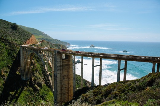
BIG SUR, CALIFORNIA! “Bixby Bridge is Big Sur’s version of the Golden Gate,” says photographer Jessica Sample. “If you’re driving down from the north along Highway 1, it marks the start of the most spectacular views, where dramatic cliffs and redwoods meet the Pacific.” PHOTOGRAPH BY JESSICA SAMPLE

BROOKLYN BRIDGE, NEW YORK! For decades, American flags have flown continuously on the towers of the Brooklyn Bridge, which has been one of New York City’s most beloved attractions since its completion in 1883. “I waited for the perfect opportunity to capture the setting sun dipping low enough to shine between one of New York’s oldest icons and one of its newest—the Freedom Tower at One World Trade,” says photographer Erika Skogg. PHOTOGRAPH BY ERIKA SKOGG
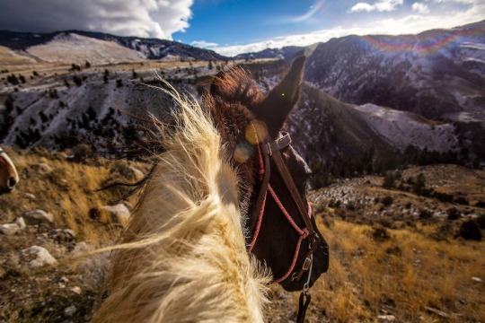
JARDINE, MONTANA! Trail riders overlook Yellowstone National Park near its northern border. Horseback rides are popular with tourists looking to slow down and take in the park’s vast, captivating landscapes. “After decades of living and working abroad,” says photographer David Guttenfelder, “I was lured back to America” on assignment to the iconic western park. PHOTOGRAPH BY DAVID GUTTENFELDER
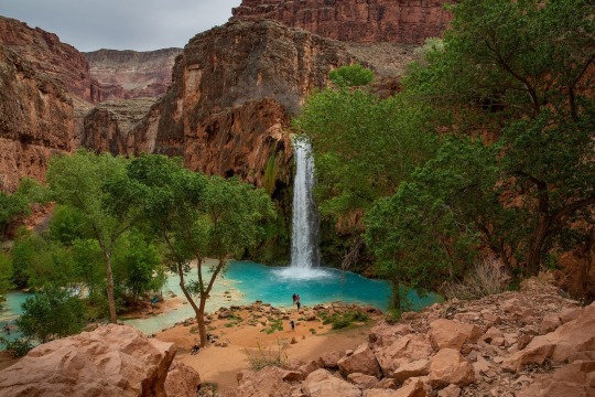
HAVASU FALLS, ARIZONA! Grand Canyon hikers and campers book reservations far in advance to experience the vibrant waters of Havasu Falls in the Havasupai Reservation. “This has to be one of the most beautiful landscapes I've ever seen in America,” says photographer Daniella Zalcman. “This area is also deeply representative of American land in a different way: For nearly a century, the U.S. government reduced the Havasupai's tribal lands to a mere 518 acres (less than a square mile) at the bottom of the Grand Canyon.” In 1975, 300 square miles were granted back to the Havasupai. PHOTOGRAPH BY DANIELLA ZALCMAN

ROUTE 66! The fabled Route 66, also known as the “Main Street of America,” stretches from California to Illinois and draws thousands of domestic and international tourists a year. “We were driving an old 1973 Ford Mustang,” says photographer Matthieu Paley, “adding to the American experience of the Wild West I had read about as a kid.” PHOTOGRAPH BY MATTHIEU PALEY

ARCHES NATIONAL PARK, UTAH! The bright stars of Cygnus shine above Three Gossips rock formation in Arches National Park. “[It’s] an iconic American destination to me,” says photographer Babak Tafreshi, “because [it’s] a symbol of conservation and [the] U.S. Southwest’s natural wonders.” PHOTOGRAPH BY BABAK TAFRESHI
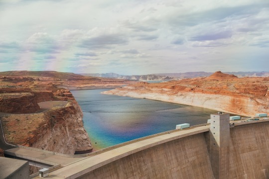
THE GLEN CANYON DAM, ARIZONA! Mammoth Glen Canyon Dam is part of a 1.25 million-acre national recreation area that offers stunning desert hikes, lake sports, and unparalleled stargazing. “You can come here to marvel both at the human spirit and power of nature,” says photographer Michael George. PHOTOGRAPH BY MICHAEL GEORGE
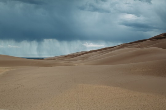
GREAT SAND DUNES NATIONAL PARK, COLORADO! An afternoon thunderstorm rolls above Colorado’s Great Sand Dunes National Park. “Knowing this park has dunes that tower some 750 feet, the tallest in North America, is astonishing,” says photographer Spencer Millsap. PHOTOGRAPH BY SPENCER MILLSAP
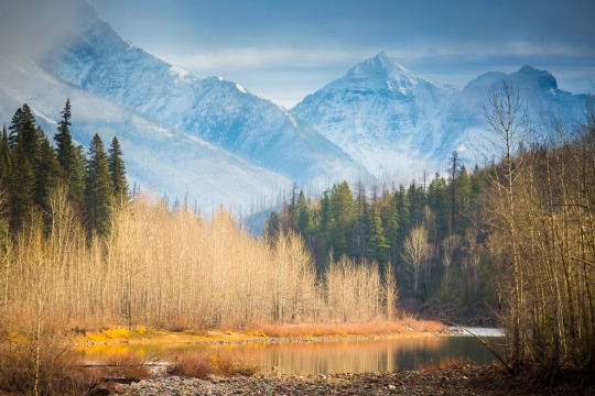
GLACIER NATIONAL PARK, MONTANA! Montana’s Glacier National Park is iconic “because of its breathtaking, glacier-carved peaks and flowing river valleys,” says photographer Emily Polar. The 10th most visited national park, Glacier welcomed three million visitors in 2018, many of them to its renowned Going-to-the-Sun Road. PHOTOGRAPH BY EMILY POLAR
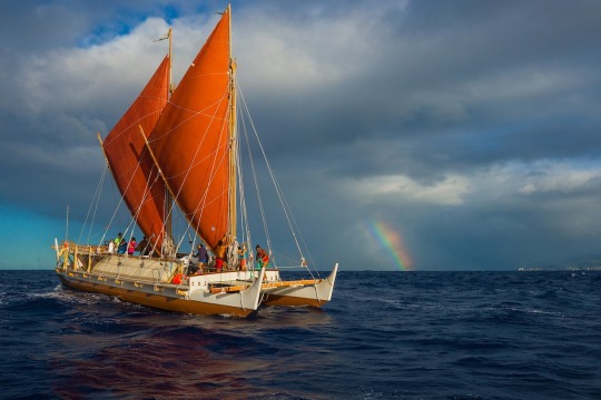
OAHU, HAWAII! A traditional Hawaiian sailing canoe cuts through the water off Oahu’s West Side. Sailing “is how the first Polynesians came to Hawaii, and how America became what it is today,” says photographer Cristina Mittermeier. “The history of America is bound to the story of the immigrant and the settler and indigenous peoples and the awe of new discovery.” PHOTOGRAPH BY CRISTINA MITTERMEIER
1 note
·
View note
Photo
Amazing what some wind and water can do! Found these on a trail by the Glen Canyon Dam Overlook Trail. 📷 @canonusa Rebel T7i Lens @sigmaphoto 18-300mm #page #pagearizona #antelopecanyon #socalshooters #sandiegophotographer #nature #naturephotography #naturelovers #arizona #arizonaphotography #southwest #southwestphotography #landscape #landscapephotography #lowerantelopecanyon #explore #explorepage #exploremore #exploreaz #explorearizona #wander #wanderlust #wanderer #naturalbeauty #sdphotosquad #hiking #hikingadventures #earthwonders #earthbestshots #earthplanetpics (at Glen Canyon Dam) https://www.instagram.com/p/CepItvlvQkG/?igshid=NGJjMDIxMWI=
#page#pagearizona#antelopecanyon#socalshooters#sandiegophotographer#nature#naturephotography#naturelovers#arizona#arizonaphotography#southwest#southwestphotography#landscape#landscapephotography#lowerantelopecanyon#explore#explorepage#exploremore#exploreaz#explorearizona#wander#wanderlust#wanderer#naturalbeauty#sdphotosquad#hiking#hikingadventures#earthwonders#earthbestshots#earthplanetpics
0 notes
Text
Fall off the cliff
A 25-year-elderly person is dead subsequent to falling in excess of 250 feet off a precipice to his demise as he was taking pictures at a picturesque disregard, as per the National Park Service.
The episode happened when the National Park Service Dispatch at Glen Canyon National Recreation Area got a report at roughly 9:04 a.m. on Oct. 4 demonstrating that a man had tumbled off a precipice.
MORE: 2 understudies fall four stories while taking selfie at roof party
The NPS revealed that observes saw the man, later distinguished as Orlando Serrano-Arcola from Phoenix, taking pictures at the Glen Canyon Overlook close to Page, Arizona, prior to falling an expected 100 feet and afterward sliding roughly 150 feet further down into the ravine.
"A Coconino County Sheriff's Office Deputy rappelled to the casualty at 9:27 a.m. also, affirmed the casualty was perished," the NPS said in an explanation. "The Coconino County Sheriff's Office, National Park Service, Page Police Department and U.S. Authority of Reclamation gave help recuperation tasks. The casualty was moved to the Medical Examiner's Office in Flagstaff for a post-mortem."
Public Park Service
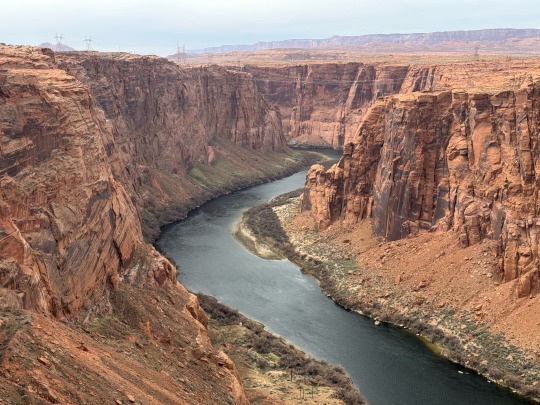
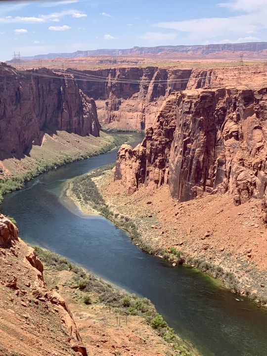
Colorado River from the Dam Overlook.
MORE: Suspected carjacker leads police on 100 mph pursue prior to driving off precipice and into the sea
Authorities, be that as it may, made another terrible - - however inconsequential revelation when they were currently recuperating Serrano Arcola from the gorge: one more arrangement of human remaining parts.
"Officials from Glen Canyon National Recreation Area and the Coconino County Sheriff's Office found bones at the foundation of the Glen Canyon Dam Overlook on Sunday, October 4, that not entirely set in stone to be human remaining parts," the NPS said in a different articulation to the one about Serrano-Arcola. "The disclosure was made while recuperating the body of an irrelevant casualty in a similar area."
MORE: Man drives off precipice and departures without any wounds in 'supernatural occurrence' crash
It isn't known who the human remaining parts that were found while recuperating Serrano-Arcola have a place with, how long they had been there for or how they arrived in any case.
Specialists are currently leading examinations concerning the two cases and the NPS have said more data will be delivered when it opens up.
0 notes
Photo
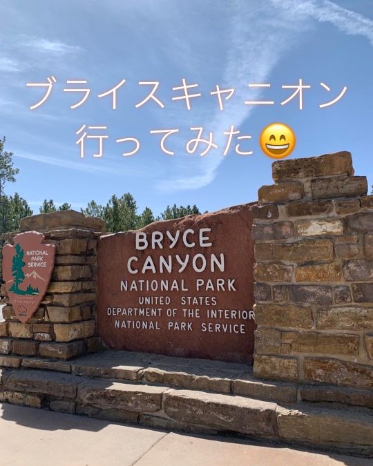
ロードトリップ2022春 Day2 その3️⃣ Horseshoe BendとGlen Canyon Dam Overlookを後にして車で約3時間🚗💨次に向かったのはブライスキャニオン国立公園 @brycecanyonnps_gov でした😄 これらの不規則に尖った岩の集まっている様は”hoodoos”と呼ばれており、地球上で最も”hoodoos”が集まっている場所なのだそうです🤔 3, 4枚目 : Sunset Point付近のトレイル 5枚目 : Natural Bridge 6, 7枚目 : Bryce Point 8, 9枚目 : Upper Inspiration Point #brycecanyon #brycecanyonnationalpark #ブライスキャニオン #ブライスキャニオン国立公園 #spring2022 #ロードトリップ #アメリカ生活 #アメリカ在住 #アメリカ駐在 #アメリカ暮らし #海外生活 #海外赴任 #駐在 #駐在生活 #シリコンバレー #シリコンバレー生活 #SiliconValley #サンフランシスコ #サンフランシスコ生活 #sanfransisco #サンノゼ #サンノゼ生活 #sanjose #ベイエリア #ベイエリア生活 #bayarealife #calilife #カリフォルニア #カリフォルニア生活 #カリフォルニアライフ (at Bryce Canyon National Park) https://www.instagram.com/p/CdIGKPJONBb/?igshid=NGJjMDIxMWI=
#brycecanyon#brycecanyonnationalpark#ブライスキャニオン#ブライスキャニオン国立公園#spring2022#ロードトリップ#アメリカ生活#アメリカ在住#アメリカ駐在#アメリカ暮らし#海外生活#海外赴任#駐在#駐在生活#シリコンバレー#シリコンバレー生活#siliconvalley#サンフランシスコ#サンフランシスコ生活#sanfransisco#サンノゼ#サンノゼ生活#sanjose#ベイエリア#ベイエリア生活#bayarealife#calilife#カリフォルニア#カリフォルニア生活#カリフォルニアライフ
1 note
·
View note
Text


Glen Canyon National Recreation Area, AZ (No. 6)
Glen Canyon's overall design was based on that of Hoover Dam – a massive concrete arch-gravity structure anchored in solid bedrock – with several significant changes. The engineers wanted the dam to rely predominantly on its arch shape to carry the tremendous pressure of the impounded water into the canyon walls instead of depending on the sheer weight of the structure to hold the reservoir back, as had been done at Hoover. The foundation rock at Glen Canyon consists of porous sandstone prone to spalling, in contrast to the stronger granite at the Hoover Dam site, forcing the Glen Canyon design to follow more conservative lines by greatly thickening the abutments, thus increasing the surface area through which the weight of dam and reservoir would be transmitted to the rock and relieving the pressure per square inch on the highly breakable cliffs.
The Glen Canyon Dam is 710 feet (220 m) high from the foundations and stands 583 feet (178 m) above the Colorado River. The crest of the dam is 1,560 feet (480 m) long and 25 feet (7.6 m) wide, while the maximum thickness of the base is 300 feet (91 m). The elevation at the crest is 3,715 feet (1,132 m), and the elevation of the Colorado River below the dam is 3,132 feet (955 m). In total, the dam contains 5,370,000 cubic yards (4,110,000 m3) of concrete and 28,900,000 pounds (13,100,000 kg) of reinforcing steel. The hydroelectric power station and river outlet works are located at the foot of the dam. The outlet works consist of four 96-inch (240 cm) diameter pipes, each controlled by a ring gate and hollow-jet valve. The discharge capacity of the river outlet works is 15,000 cubic feet per second (420 m3/s).
Source: Wikipedia
#Glen Canyon Dam Overlook#Glen Canyon National Recreation Area#Glen Canyon NRA#GCNRA#Lake Powell#Coconino County#Southwestern USA#Colorado Plateau#desert#flora#nature#blue sky#clouds#grass#travel#original photography#vacation#tourist attraction#landmark#landscape#countryside#USA#Arizona#summer 2022#red rock#Page#Glen Canyon Dam#engineering#technology#Colorado River
3 notes
·
View notes

Photo
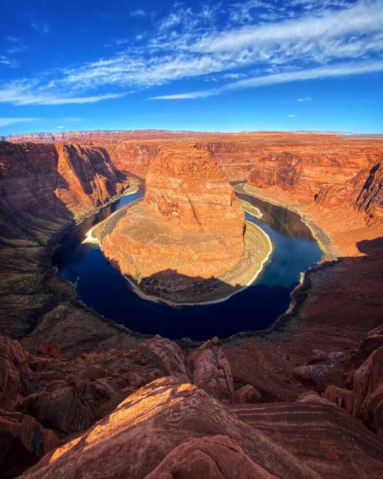
Horseshoe Bend in Glen Canyon National Recreation Area. Often confused with being part of the Grand Canyon, this famous overlook is about halfway between the Glen Canyon Dam and Lake Powell in Page, and the beginning of Grand Canyon National Park’s Marble Canyon at Lee’s Ferry, Arizona. #ArizonaGuide #horseshoebend #glencanyon #grandcanyon #nationalpak #page #arizona #coloradoriver #colorado #river #rafting #water #whitewater #canyon #desert #powell #utah #southwest #geology #sandstone #navajo #sunrise #sunset #boat #boating #adventure #lakepowell — Nate Loper
9 notes
·
View notes
Photo

Adventure Time (at Glen Canyon Dam Overlook) https://www.instagram.com/p/CR-JEQGlXfP0UfqE0ekvplBTZQ7UYCO5qPVXMo0/?utm_medium=tumblr
1 note
·
View note
Photo

Glen Canyon Dam Overlook, Page, USA, November 2020 [OC][3000x4000] via /r/EarthPorn https://ift.tt/38nuIwX
2 notes
·
View notes
Photo

Glen Canyon Dam Overlook, Page, USA, November 2020 [OC][3000x4000]
1 note
·
View note
Last Seen Blogs

frei-und-schwerelos
imma throw gay wicked hands

hopefullyandrogynousartist
i'm not really that androgynous

cottagecori
you'd have to stop the world to stop the feeling

hoomandoescosplay
hooman_does_cosplay

spookylightcowboy
Shloka