
sarahrobkiwi
Sarah's Log
The Misadventures of a DIY Travel Chick
6 posts
Don't wanna be here? Send us removal request.
Last Seen Blogs
leosuxxx
starring role

oliviloi
🌻🍃🍄🍂
the-fo0l
˗`welcome ˊ˗

planttoucher-blog
cerulean pride

theabysscomeshome
Here for the eldritch and horrifying
Photo
Good intentions v reality! #pharquecoronavirus #sailinglife #unemployedsailors (at Taupo, New Zealand) https://www.instagram.com/p/B-AtkpWBmae/?igshid=jdeaaaow92pm
0 notes
Video
Winter!!! It's here!! #sailfearless #winter #lovetaupo #greatlaketaupo (at Lake Taupo) https://www.instagram.com/p/ByPFtnrBeen/?igshid=4dx0i3hx1wu9
0 notes
Photo

Another hard day in the office! Making the most of the last of the sunshine! #sailfearless #lovetaupo # rockcarvings (at Maori Rock Carvings Lake Taupo) https://www.instagram.com/p/BwUGB6vBFbM/?utm_source=ig_tumblr_share&igshid=edyn5wzih26r
0 notes
Text
River Exe and Dartmoor
Date: December 2012
Position: 50°34′N 4°0′W
Conditions: Grey and raining, grey and not raining
Exeter Map
Dartmoor Map
Escape from London
In London, the five days between bank holidays over Christmas can be a bit grim; a) weather wise b) a general lack of things to do. Not much tourism stuff tends to happen. This gives one time to dream up destinations - for less than 40 quid on a train. A tour of the south-west corner held considerable appeal. Devon and Cornwall were meant to be. I thought I was ace with Uk public transport now but found myself in the twilight zone of travel in the Southwest.
It is a lovely ride from London through the Salisbury Planes. Everything looks so manicured - neat hedgerows, naked trees, stone buildings with thatched roofs and rolling hills. Very pastoral! Little villages flash by, railway stations looking like they come from Thomas the tank engine. I made it as far as Exeter and found a cheap B&B next to the train station, dropped my stuff and set off to explore.
There is something to be said for not knowing much about where you are going. It is usually a pleasant surprise. Surprise number one was crossing the River Exe into town to find the Medieval Exter Bridge. Built circa 1200 BC, its remains are high and dry in a park now as the River Exe has moved further west. I thought it was Roman. It turns out it wasn’t! A quick walk up Stepcote Hill, a cobbled street which is the oldest in the city and used before Roman times to access the River Exe, a few twists and turns and I found myself on High Street.
High Street
I knew there would be a cathedral nearby - after all this is England - but it wasn’t immediately apparent. Of course, I didn’t have a map. Feeling a little bit dispirited and a lot of hungry, I availed myself of some traditional local fare from a lovely Turkish kebab shop and wandered into an arcade.
Looking longingly through the windows at sparkly things that broke backpackers do not need, I headed towards the glimpse of green I could see what looked like a charming courtyard. As it turned out, it was the Cathedrals close. It is gorgeous. The cathedral had scaffolding around it, forcing me to take some very artistic (read crappy) shots from different angles, but you get the general drift of what it is like. I hung around until after dark, and it just got prettier. Unfortunately, my photos did not!
Crossing the Exe
Heading back, I ambled over the Cricklepit Bridge, got distracted by swans and ended up following Quayside and past the olde Customs House. Cue more underexposed photos of swans and buildings! I stopped by a service station and grabbed a map. It would have been handy two hours ago. Hindsight is a great thing.
Rocking back to the hotel, I settled in for some last minute planning. I wanted to explore the other side of the close, that I didn't get to do today. The next day was Dartmoor National Park - I knew there was a big prison there, but not much else. I should have known better! That was the last I would see of Exter for the next two days.
Dartmoor
It was bright and early that I set off to pick up my wheels for the next few days.
As a general rule, roads in the UK are small; ergo they lend themselves to small vehicles. A broke backpacker has limited resources, so a small car kills two birds with one stone. A wee red Fiat 500 won the day. I decided to swallow my pride and rent a GPS. Whilst not my favourite piece of technology in the world (who likes maps that yell at them every opportunity possible) they do have some advantages. It was to my relief I found this one didn’t screech recalculating every five seconds when I ignored its instructions. It just shut up and quietly said take the next left turn. I thought this one might last the distance - famous last words.
So with Dartmoor National Park firmly in my sights, ham and cheese sandwich packed in case of emergency starvation, I hit the road. As we all know, rental cars are the best in the world. They are the strongest, toughest, fastest cars that can go anywhere. Thank god the Fiat had no idea what it was in for - and to be fair, neither did I! Dartmoor is crisscrossed with roads and villages. With a history of human settlement, agriculture and mining, of thousands of years, I was surprised to find such a sense of wilderness and isolation.
GPS
Previous experience has taught me to be wary of the GPS. It is an excellent way of getting you from A to B - via new routes. At least when you look at a map, you have no excuse for not expecting the one lane dirt road that you find your self on. Especially, when said road looks like some unsuspecting farmers driveway - leading to their cowshed. As I was to find out, this is what the roads in Dartmoor are like. The great thing about Flea was it could fit through any gap, and if I got stuck, I could probably push her out by myself. It was touch and go a couple of times. And that's what makes road trips so enjoyable.
The first destination I had set was Dartmeet - which is where the East and West Dart Rivers meet - funnily enough. I found my only patch of sunshine looking down on the Clapper Bridges. These are stone bridges over 7000 years old. The people who made them are long gone, but the bridges remain, and you can still cross rivers on them in different parts of the park.
Dartmoor Prison
Dartmoor Prison is a sight. Approached from the south, it appears across the fields like a massive, imposing granite outcrop. It was tipping down with rain, which just made it that much more grim and foreboding. Not that I have any intention of ever going to prison, but seeing that, only reinforces why prison would not be a great place to spend time. Probably because of the weather, I thought the whole of Princetown around the prison looked downright depressing. I was mildly disappointed not to see prisoner walking the streets. They should pay students to walk around there in boiler suits with ankle chains to improve the ambience!
Sitting on the side of the road in the rain eating my cheese sandwich with only the Dartmoor ponies for company, I thought if a dragon were to fly by followed by twelve knights on horseback, I would be okay with that. Nor would I have had a problem if Heathcliff and Cathy appeared - the wrong moor, but a moor no less!
At this point, as I was starting to trip out on King Arthur legends, Bronte and now prison chain gangs, I thought it might be time to start working my way out of the park and find more ruins. Off I headed to Okehampton. Now a couple of times already the issue of being between the two main public holidays of the year had reared its head, Okehampton was no different. The ruin was closed - but the gate was easily stepped over to go and have a nosey around. Not that I advocate that kind of behaviour. At all. Ever.
I was starting to run out of daylight at this point. After a very brief consultation with the GPS, I had a decision to make. Back to Exeter or on to Cornwall????
Cornwall it was, but that is another tale! Cornwall in a Day
0 notes
Text
Date: July 2015
Position: 19°49′40″N 155°28′05″W
Conditions: Dry and sunny on one side, warm and wet on the other
Mauna Kea Map
Chevy Sparks don't fly
At 10000ft altitude, a Chevy Spark runs out of puff. So does the person driving it! That is because said driver realises that if she wants to get to the top of Mauna Kea, she will have to a) climb a further 4000 ft up a gravel road or b) hitch a lift. Guess that what happens when you take a rental car where it shouldn't go. Thank god the rental company didn't think to check instatwitface after the car was returned - hired by one careful lady driver on the wrong side of 40 - what could possibly go wrong!
As it was, poor wee Blueberry (the Chevy mentioned above ) got abandoned on the side of the road, while I contemplated my immediate future. I am all for adventure sports, but, getting older and lazier by the minute, climbing was not the favoured option. The lack of vehicles out for that particular scenic drive was disappointing. Following a contour line instead of gaining altitude, I found a wee knob to climb that looked back towards the Pacific Ocean.
An hour beforehand
Mauna Kea was a last-minute decision made while scoffing a late breakfast of fried rice in a rest area on the coast road, looking at Haleakala on the island of Maui, feeling pretty choice about where I was. Looking over my shoulder, I noticed there were no orographic clouds on the summits of both Mauna Kea and Mauna Loa that morning. Instant change of plans! My drive to see King Kamehameha's statue was postponed while I went on a big trip! Kicking myself that I didn’t rent a 4x4 at this point, I thought I would see what Blueberry could do as we all know, rental cars are the best, and go everywhere - well almost everywhere!
Views
The views are spectacular. All the little hills you don't pay much attention driving between these two massive volcanoes to turn out to be cinder cones. Mauna Loa dominated the view from rocky outcrop where I was sitting. Its height from the sea floor means that as a single entity, it stands higher than Mount Everest. In a cold winter, you can ski there! Crisscrossed with lava flows, the more recent look black, against a background of red dirt and yellow grass. Spinning back around, Mauna Kea rises behind a dark red rock. And Mauna Loa is higher. Visitors before me had left offering to Pele.
In for a penny, in for a pound, I decided. Blueberry should attempt the two highest peaks in Hawaii in one day. Looking across the valley to Mauna Loa, I figured the observatory I could see must be a similar altitude to my current situation - easily achievable, and if the road was sealed further, I should get higher.
Now a funny thing happens as you drive down Mona Kea. You notice lots of things you don't see when driving up. Namely, all the lava flows crisscrossing the valley floor, and cinder cones that you just drove past without paying much attention too. I kept hearing my granddads voice in my head complaining about the water in the bottom paddock when the river flooded. In Hawaiian terms, the complaint would go along the lines of “god dang it Flo, gotta move the sheep cause the lavas back in the bottom paddock”.
Mauna Loa
There is a little hill beside the highway, surrounded by black lava flows, and it wasn’t too hard to imagine it as an island in a sea of lava. I headed around that to tackle the road up Mona Loa. I had a rare attack of the sensibilities when I looked at the way ahead. Unlike Mona Kea, which is a lovely two-lane road until it runs out of seal at 10000 ft, the drive up Mona Loa carves through lava flows - that reminded me of snow drifts. The sign said to be aware of oncoming traffic. Oncoming traffic would be looking out for other ridiculously oversized SUV’s driven by intrepid tourists, rather than a wee Chevy Spark, driven like it was stolen. Having pulled off a stellar three-point turn on about half a foot of roadway, I headed back on to Saddle Rd.
Ancient pathways
Now the whole point of the late start in the morning was to sleep in and have a cruisey day. Yesterday I had driven from Kona to the Volcanos National Park and back - another whole story, and I was tired. Being the sensible person that I am, I decided on a rapid circumnavigation of the Big Island. Saddle Road bisects one of the old Hawaiian pathways. When the paths crossed aa lava flows, they cleared tracks by moving the loose cinders aside. Where it was a pahoehoe flow, cairns were laid to mark the way. I walked a short way down the path through the scrub. Next time, the whole track!
Windward vs Leeward
There is a very cool demarcation between the windward and leeward sides of the islands. The leeward sides are all dry and barren scrublands. The windward sides are wet and juicy rainforest. There is almost a line across the island that one of the ancient Hawaiian pathways runs alongside for a bit. You are driving along in bright sunshine through grasslands, then splat, straight into the cloud, rain and forest.
The drop down into Hilo was punctuated by outbreaks of the sun, amid the tropical rain - all in the space of about 20 minutes. This means there are some serious waterfalls to check out and check most of them out I did. It is funny watching people walking around in tropical rain trying to keep dry. It is impossible. And it's warm. Leave your towel handy for when you get back to the car to sit on. Don't bother getting dried off because you are going to do it all again shortly. Or the sun might appear again!
The Coast
There is a charming scenic drive along the coast just north of Hilo - the old Mamalahoa Hwy. Being serious about sight-seeing, I thought this would be a good one to take. Against the advice of my GPS, I set off down a labyrinth of one-way bridges and jungle along a coastline I could hear but not see. Driving through tropical rainforests is otherworldly. My photos do not do it justice. The Greens are greener, the flowers scream “look at me”, and birds look like they have crashed into a rainbow. My photos need a whole lot of work in Lightroom to get everything looking like it does in my memory! Apologies for the sad examples of my work attached!
Rejoining the modern Mamalahoa Hwy, my return to Kona it was a blur of waterfalls, rain, more rain, coastal villages before dropping back into Kona and a well-earned beer!
0 notes
Text
Simon
Date: January 2012
Position: 36°10′30″N 115°08′30″W
36°0′56″N 114°44′16″W
36°18′N 112°36′W
Conditions: Freezing
GC Map
Round One, Plans
The day started innocuously, I didn't sleep in, the taxi was prompt, took the direct route and there were no roadworks or car accidents to contend with. It was all going swimmingly! The prior organisation had many positive benefits! Usually, I book everything at the last minute and get annoyed with myself paying full price for whatever remains on the shop floor. My photo albums are a catalogue of where I ended up, not where I intended to go. Not this time. This time was going to be different. This time I Had A Plan. And I was going to Stick With It. So far, so good.
Booking in advance is great, you get what you want, at the best price and at the time and place you want it. I had even found favour with the weather gods. The sky was blue; the air was crisp and descriptive narrative would demand the sound of birds chirping. As I was standing beside the airport, the last part of that sentence was redundant, but you know what I mean.
The red Mustang
My trusty steed for the next two days was shiny red Mustang with only 1000 miles on the clock. An extra ten dollars saw it morph into a convertible. Sweet! It had no idea what it was in store for it. A Mustang may seem somewhat excessive for a couple of days local sightseeing. In my defence, that particular juncture of my life had me living on a tiny rock in the middle of the Atlantic Ocean, the current mode of transport being a rather sad, green, 100 cc scooter with a top speed that would make an asthmatic cat look like a cheetah. A girl doesn't always have to be sensible with her car choice. Cliche - but hey, a red Mustang looks great in photos!
Previous experience has taught me to be selective with travel companions. Great friends in real life do not always make the best travel buddies. Endearing, quirky traits can quickly become incredibly annoying. Solo travel can be a pain - there is no one else to blame. Mind you; you do not have to negotiate with yourself - a bonus! With this in mind, I decided company would be cool for this road trip, so the last minute decision was made to include a travel buddy. I picked up a personable chap named Simon.
Buddies
Short term relationships can be tricky. I have found, if approached in a business-like manner, usually both parties needs are met, rather than following the usual trajectory of my more long-term relationships. Starting with excitement and bliss, before long the nagging begins, then minor criticisms escalate, disappointment sets in as fallibility is uncovered leading to the inevitable parting of ways. So I made my expectations explicitly clear. I like to drive. And I am good at it. Simons role was copilot - provide details on upcoming corners and lanes, landmarks of note and most importantly, point out local sources of food. Oh, and exciting things to stop and take photos of on the way.
Expectations
With this in mind, I laid out my itinerary for the next 48 hours. Simon raised his eyebrow and exclaimed, “don’t you think that’s a bit far?” He did not seem reassured when I insisted that my expectations were achievable. I had lived for a short time in a very hot, dry country, where one drives Outback about 400 miles between fine establishments that serve lukewarm pots of XXXX (because the locals can’t spell beer), garnished with flies and red dust. Driving through sagebrush desert on an Interstate should pose no problems to a seasoned pro like moi.
Open Road
So, with the course to steer agreed, we set forth on our adventure. Challenge number one - the freeway. It's busy. I find it so rude other people want to use the road at the same time I do. At least we were all travelling in the same direction. It was on about the third rather large interchange that Simon started to get a bit stressed. He wasn’t that quick at anticipating lane changes, leading to a couple of dodgy manoeuvres, but I was able to pull it off with minimal apologetic waves to other road users and not too much honking in my general direction. So far though, it was all good.
The next fifty minutes where bliss. Cleared the city, open road in front, blue skies overhead, snow-covered peaks in the distance, the joy of driving somewhere entirely new. A companionable silence, iPod shuffle picking appropriate roadie tunes. I knew it was too good to last. One hour in, I figured I was coming up to my first stop. The signs were all there; valleys narrowing, pylons and power lines converging on the course of the highway.
Falling apart
And then the rot set in. I followed the signs, a tried and true method of getting to exactly where you want to - especially when it is a rather well-known tourist destination. The nagging started. His voice took on a horrible whinging, tone.
“Turn Back!!!! Make a U-turn when it’s safe”.
“Sorry bud, I am following the road signs. I can see where I want to go!”.
“No, turn back, the map says it’s the next corner."
“Mate, just use your eyes, the layout of the road has changed. I reckon that map is out of date!”
“Turn back, turn back."
“Shut up! I’ve got this sorted”.
“Turn around!”
“Listen, you silly man, I am right, and you are wrong. Watch this!”
His accent, which initially I found quite cute was now starting to annoy me.
Vindication
He made one last half-hearted attempt to assert his authority - to no avail. It did occur to me that this is possibly the cause of so many tourist-related road accidents. Arguing over directions and not paying attention to the actual driving business - especially when driving on the ‘other side of the road’ and trying to admire the scenery. I stuck to my guns, feeling somewhat vindicated as I received my ticket for the parking building overlooking a rather spectacular feat of engineering with an impressive lake behind it. Simon was oblivious. Round one to me.
Round Two, More Plans
So, we’ve had our first fight, and the dust has settled. One memory card full of photos, a slight case of vertigo conquered, votive feet rubbed and thirst quenched, I decided it was time for round two, the next stop. About half an hours drive through some pretty expansive countryside and even better, some of it off the beaten track. A quick discussion with Simon ensued. He seemed happy with the destination. A relatively straightforward trip.
Hope
We set off, full of hope and high expectations for our future. Exciting! Cruising along, the vista expanded. Sagebrush and dry earth framed by blue sky and mountainous ranges retreating into the distance. The number of billboards advertising must do casinos and resorts falling by the wayside. I was admiring the scenery, chilling as you only can do on the open road when I noticed Simon had become rather less communicative. Worried he had gone to sleep, I poked him. No response. I became concerned. We needed to talk. Thinking about the best way to approach this, I found a lay-by, eased the car off the road killing the engine.
I composed myself - even paused the iPod. Not wanting him to feel ambushed, I asked for advice, - what should I do? Met with a stony silence that became deafening, I could tolerate it no longer. This was important. I realised that while I do make snap judgments in relationships, I actually did wanted this one to succeed. Prepared to pull out all stops, I poked and prodded him. He stirred. Yay, there was hope! I questioned him about our destination, why had he withheld directions from me only to find I had been cruelly deceived. He had no intention of supporting me on my journey. Instead, he had tried to subvert it with his own plans.
Dumped
It was over. Done. No hope of redemption. I consigned Simon to the back seat - it did seem a bit nicer than dumping him on the side of the road in the middle of nowhere.
Now rudderless and adrift I was somewhat elated. I could do this alone. I did not need Simon. The blacktop stretched as far as the eye could see (well, to the next bend). Considering my options, I could retrace my steps, work out where it all went wrong, be reflective, gain insight, learn from this experience. Or not.
I chose ‘or not.' With Simon and his maps sitting quietly in the back, I turned the music up and pressed on. Passing through towns, I skirted around cities, crossing bridges and drinking in the ever-changing scenery. So different from home, I stopped to shoot pics of trees, river beds, gorges, abandoned buildings, pinching myself that I was here.
Second Chances
In the spirit of inclusion, I asked Simon for recommendations for food only to be met with an offhand comment about fast food restaurants - I got the feeling he was sulking. When choices are limited, beggars cannot be choosers. Simon advised the Golden Arches at the next exit, which involved a traffic light, left-hand turn, followed by crossing traffic. The Colonel’s restaurant was on my side of the road instead, so the Colonel’s it was! That lead to a slightly twilight zone experience - having sampled his wares in many nations now, I was surprised at how unfamiliar the menu was. I escaped with a popcorn chicken combo and the feeling that I had visited an alternate reality, thinking next time the drive-through might be the best option. The upside of franchises is their toilets are usually clean, tidy and well lit!
The tonne
My journey continued, and my ears began to pop. It would appear I was gaining elevation - a 7000ft elevation marker confirmed this along with the white stuff on the side of the road that was not frost! It was snow. Blasting on, I had seen no signs of humanity in over an hour so had picked up speed. I was cruising at 100, so it was an unpleasant shock when I passed a car parked discreetly on the side of the interstate. A quick glance at the speedo and more than a few nervous double checks in the rearview mirror to confirm no red and blue lights were behind me - I gave thanks to the gods for doughnuts! It did remind me to check my speed more often - especially now that Simon was not talking to me.
Promising exits
I found an exit that looked promising. A quick stop at a roadside diner for a rather tasteless filter coffee, I confirmed with the friendly locals I was on the right track, but some distance still to go until the main event. The scenery had changed markedly. I was now driving through Kaibab forest with snow drifts taller than me on either side of the road. At five foot ten, that’s lots of snow! I pressed on, aware of the passage of time by the changing angle of the sun. I became concerned about the volume of traffic travelling in the opposite direction to me. It would appear that everyone was leaving the district and me, the only person choosing to visit. This started to prey on my mind. Why? Was it shut? Had it washed away? Had I not read the signs correctly?
Securing digs
The next village I came across, I pulled in to the first readily accessible hotel (i.e., I didn’t have to cross traffic in icy conditions and negotiate narrow entrances!), found reception, rang the bell and enquired about vacancies. Not a problem. I had figured as much from the exodus I had witnessed. I secured a room at an excellent rate and asked the receptionist why it was that everyone was leaving.
“Blizzard” was her laconic reply. “Lasted two days. The access road only opened an hour ago. People have been trapped here, and now we are almost out of coffee!”
“Well, that explains it!”
“I guess ya haven’t been listening to the radio then. Where ya from anyways?”
“Clearly not from around here!” I quipped.
She cocked her head and gave me a funny smile.
“Did you want to come here, or were you going somewhere else?”.
“Well, to be fair I did have a slightly different destination in mind” I replied and recounted the adventures of my day to a sympathetic ear. I had yet to decide what to do with Simon.
Her smile broadened into a grin.
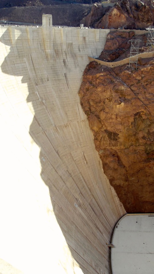
“Yeah, the Skywalk is not on GPS, and the Hoover Dam’s new road layout don’t show up yet! Catches a lotta folks out!”
Best laid plans
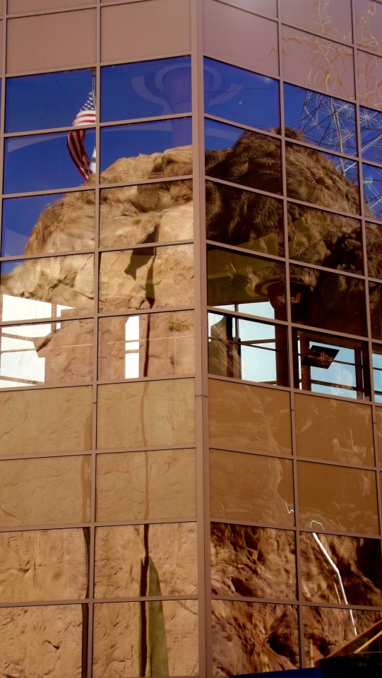
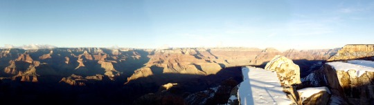
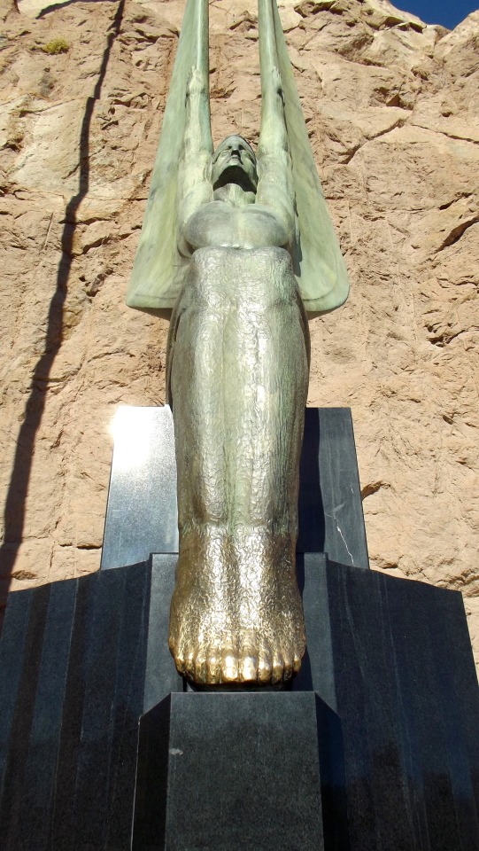
When I left my hotel in Las Vegas that morning, I had a plan that involved the Hoover Dam, Lake Mead, the Skywalk followed by a spin around the city at night, heading up to Death Valley for sunrise the next morning. Instead, I found myself standing alone on a platform overlooking one of the most awe-inspiring sights I have ever seen. The view of the Grand Canyon at sunset, covered in fresh snow from the Mathers Point Overlook on the South Rim. Looking at the bands of colour on the canyon walls, lit up spectacularly by the setting sun, down to the shadowy depths below made me appreciate how ancient this land is and how fleeting my visit was to be.
Redemption
And, then I had to go and make amends with the poor old GPS that had been thrown into the back seat of my car, having had its pedigree read to it in very explicit terms! If it weren’t for that little user error with Mr GPS and a big dose of “oh well, you only live once” I would never have experienced how genuinely impressive the Grand Canyon is.


0 notes