nyc-urbanism
NYC URBANISM
Exploring NYC architecture, history and urban planning. Website coming soon nycurbanism.com
1179 posts
Don't wanna be here? Send us removal request.
Last Seen Blogs

jopapel12
Heya
somedudewithantlers
h e l l o

jupiterslifelessmoons
How Do You Forget A Whole Sea?


the-moons-septum
Phases Of Mars
Photo
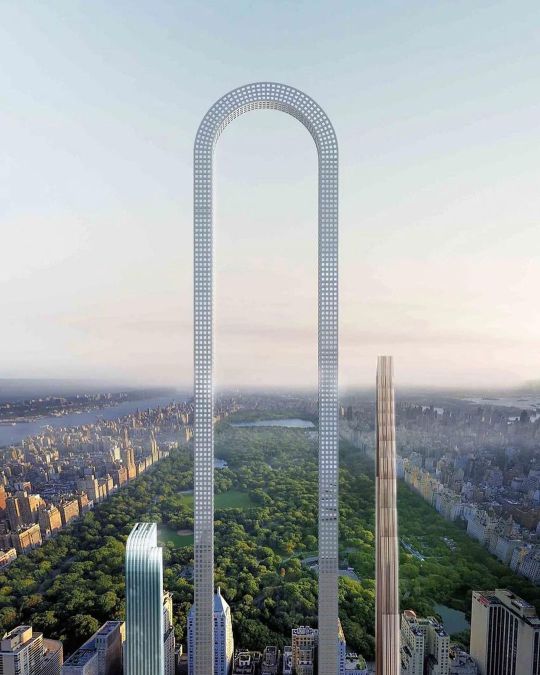
Construction has started on the future tallest skyscraper in NYC. Known as the “Big Bend” the 57th Street tower will be a thousand feet taller than the current record holder, making it the tallest in the western hemisphere and third tallest in the word. (at Central Park) https://www.instagram.com/p/CqgjjxSuukT/?igshid=NGJjMDIxMWI=
28 notes
·
View notes
Photo
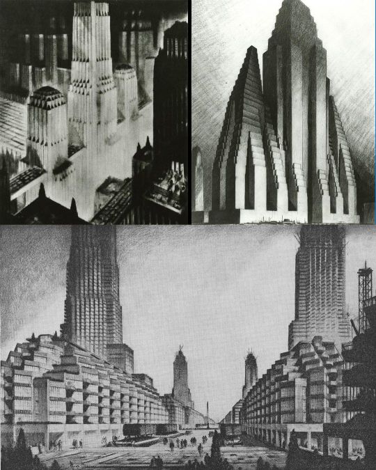
Hugh Ferris' 1922 zoning drawings showing the "Evolution of the Set-back Building." The 1916 zoning resolution required setbacks and restricted skyscrapers to a percentage of the lot size opposed to a specific height. Previously skyscrapers could rise straight up from the street with no height limits. The drawings were intended to help architects understand the rules of the zoning resolution and provided a model for the shaping a building that would use the maximum mass permitted by the zoning law. Ferris' drawings were widely published, including an article in the New York Times. He helped to inspire architects develop the new modern tower that would become the standard for 1930s setback, wedding cake, Art-Deco New York skyscrapers. This year marks the centennial of New York City's 1916 zoning resolution. #zoning #cityplanning #1916zoningresolution #setbackskyscraper #skyscraper #hughferris #nyczoning #cityplanning #modernism #artdeco #skyscraper #architecture (at Tribeca, New York City) https://www.instagram.com/p/Cqa-FXzOPRx/?igshid=NGJjMDIxMWI=
#zoning#cityplanning#1916zoningresolution#setbackskyscraper#skyscraper#hughferris#nyczoning#modernism#artdeco#architecture
42 notes
·
View notes
Photo

𝟭𝟵𝟴𝟬𝘀 𝗡𝗲𝘄 𝗬𝗼𝗿𝗸 𝗖𝗶𝘁𝘆, 𝗰𝗮𝗽𝘁𝘂𝗿𝗲𝗱 𝘁𝗵𝗿𝗼𝘂𝗴𝗵 𝘁𝗵𝗲 𝗹𝗲𝗻𝘀 𝗼𝗳 𝗽𝗵𝗼𝘁𝗼𝗴𝗿𝗮𝗽𝗵𝗲𝗿 𝗝𝗮𝗻𝗲𝘁 𝗗𝗲𝗹𝗮𝗻𝗲𝘆 California's Bay Area photographer Janey Delaney visited New York between 1984 and 1987, depicting the vibrance and character of the city's streetscape. After decades of being stored away, Delaney recently revisited and released the largely unseen NYC series. Today her award-winning photographs can be seen in museum collections including San Francisco MoMA and the Oakland Museum of California or through her publications South of Market and Public Matters. #urbanphotography #janetdelaney #nycphotography #urbanism #skyline #skyscraper #manhattan #southstreetseaport #fidi #downtown #eastvillage #1980s #sfmoma #nyphoto #brooklyn #southstreet #fultonfishmarket #kodachrome (at Lower Manhattan) https://www.instagram.com/p/CqYbEWdu7gq/?igshid=NGJjMDIxMWI=
#urbanphotography#janetdelaney#nycphotography#urbanism#skyline#skyscraper#manhattan#southstreetseaport#fidi#downtown#eastvillage#1980s#sfmoma#nyphoto#brooklyn#southstreet#fultonfishmarket#kodachrome
61 notes
·
View notes
Photo
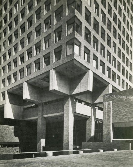
From our #BrutalNYC survey: One Police Plaza# The New York Police Department's headquarters at One Police Plaza was the heart of the Civic Center's postwar revitalization that also saw the creation of the Metropolitan Correctional Center, Murry Bergtraum High School, Chatham Green, Chatham Towers and a public plaza, all designed by Gruzen & Partners. Previously the Department had been located north of the civic center area, in a block-long Beaux-Arts building on Centre Street. To connect the new development with Park Row, the street was lowered, curving under the anchorage of the Brooklyn Bridge. Today this area has been closed to cars and surrounded by checkpoints in an attempt to secure the base of the bridge and One Police Plaza. Duane Street and New Chambers Street (through the Municipal Building) were also closed and paved with red brick. The new headquarters consisted of a brutalist ten-story red brick cube with a matrix of punched-out windows, sitting atop a multi-leveled base. The corners of the cube cantilever over the base, exposing the concrete structural elements. The mostly windowless bases house a garage, holding cells, and a shooting range. The surrounding landscaped plaza designed by architect M. Paul Friedberg was praised by critics, helping to tie the new buildings together, creating a successful public space surrounding these new developments.#BrutalNYC nycurbanism.com/brutalnyc for more #Brutal_Architecture #brutalism #brutalist (at One Police Plaza- NYC Police Headquarters) https://www.instagram.com/p/Co0Xbjquh8i/?igshid=NGJjMDIxMWI=
54 notes
·
View notes
Photo

New York Central Railroad’S "Dreyfuss" streamlined steam locomotive in front of the Trylon and Perisphere at the 1939 World’s Fair in Flushing Meadows Queens (at Flushing Meadows-Corona Park) https://www.instagram.com/p/CnDP44cuOcj/?igshid=NGJjMDIxMWI=
84 notes
·
View notes
Photo

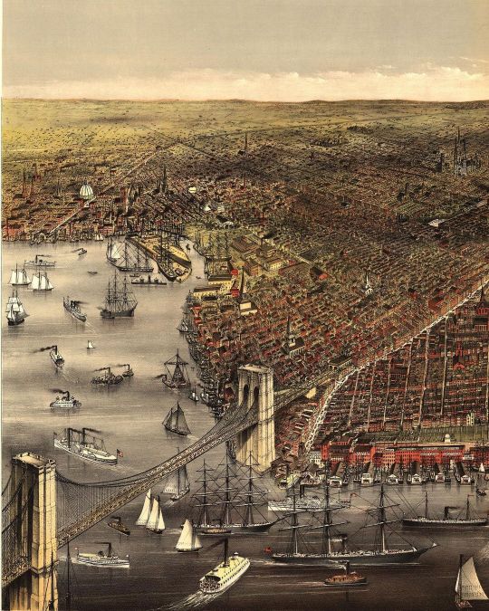
#MapMondays! Aerial view of New York, 1879 (at New York, New York) https://www.instagram.com/p/Cm7Mn7quavJ/?igshid=NGJjMDIxMWI=
77 notes
·
View notes
Photo

Union Square looking west on 14th Street, 1893. As you may notice, the design of the park is much different than today. That is because in 1928 the park was completely demolished and redesigned to accommodate the underground subway station. During this redesign the park was elevated and a fountain was added as were many statues and the colonnaded pavilion. In 1985 there was another renovation of the park to make it safer and more accessible. (at Union Square Park) https://www.instagram.com/p/CmulNbwOL40/?igshid=NGJjMDIxMWI=
16 notes
·
View notes
Photo
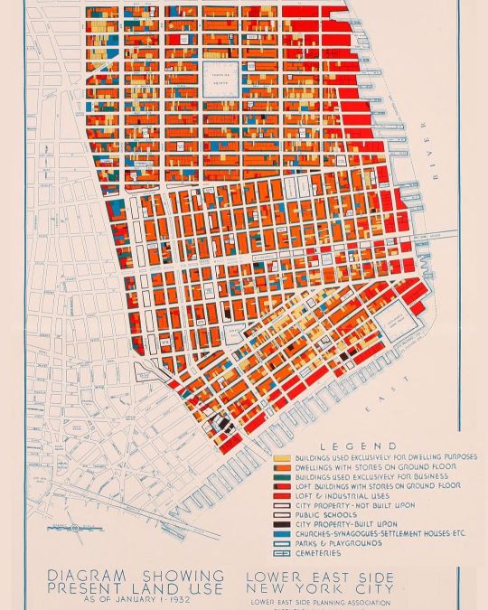
#MapMondays! 1932 map showing land uses in the Lower East Side. (at Lower East Side, NY) https://www.instagram.com/p/ClPFok5u6Ya/?igshid=NGJjMDIxMWI=
55 notes
·
View notes
Photo

Photojournalist Margaret Bourke-White taking a photo atop the Chrysler Building gargoyles in 1930. Bourke had her photo studio in the Chrysler Building. The eagle gargoyles were designed to resemble the Chrysler hood ornament. (at Chrysler Building) https://www.instagram.com/p/Ck1dt1mO7ny/?igshid=NGJjMDIxMWI=
17 notes
·
View notes
Photo
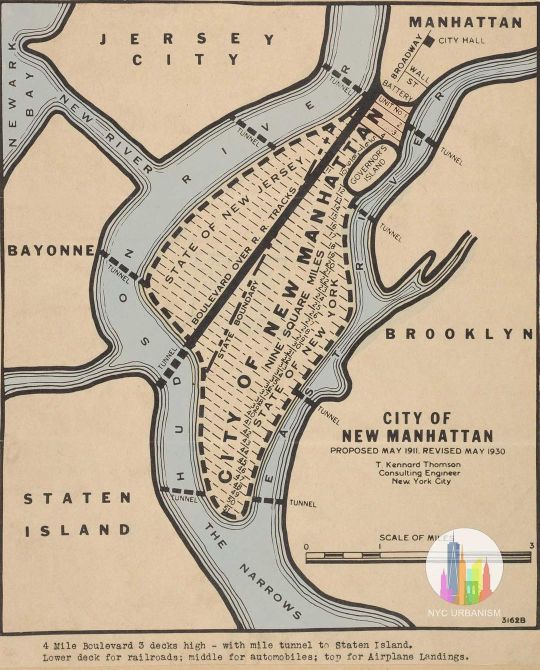
#MapMondays 1930 plan to fill New York Harbor with landfill! The proposal by T. Kennard Thomson was originally published in 1911 in Popular Science and would have filled the entire East River with landfill in addition to creating new peninsulas off of Staten Island, Bayonne and Sandy Hook, totaling fifty square miles! With the East River gone, Thomson proposed connecting the Long Island Sound back to the harbor by digging a new channel from Flushing through Brooklyn. Thomson revised the plan in 1930 (seen above), naming the new landfill City of New Manhattan, half of which would be in the state of New Jersey, separated by the extension of Broadway which would be a grand boulevard over railroad tracks flowing into a tunnel to Staten Island. This grand boulevard would be four miles long and three levels high, with trains, automobiles, and airplane landings! Tunnels would also go from Sunset Park to Bayonne, Red Hook to Jersey City, and Cobble Hill to Jersey City. #redhook #jerseycity #cobblehill #manhattan #nychistory #urbanism #longislandcity #queensny #statenisland #bayonne #eastriver #popularmechanics #civilengineering #brooklyn #dumbo #brooklynheights #tribreca #nyc #nyharbor #hudsonriver #longislandsound #urbanplanning #lowermanhattan #fidi #nycurbanism (at Governors Island) https://www.instagram.com/p/Cia2xlcOJP4/?igshid=NGJjMDIxMWI=
#mapmondays#redhook#jerseycity#cobblehill#manhattan#nychistory#urbanism#longislandcity#queensny#statenisland#bayonne#eastriver#popularmechanics#civilengineering#brooklyn#dumbo#brooklynheights#tribreca#nyc#nyharbor#hudsonriver#longislandsound#urbanplanning#lowermanhattan#fidi#nycurbanism
20 notes
·
View notes
Photo
#MapMondays! THE CITY OF BROOKLYN, 1879 Incredibly detailed "Birds-Eye-View" map of Brooklyn, showing the independent city's churches, working waterfront, parks, municipal buildings, banks, landmarks, major roads, Navy Yard and the (at the time under construction) Brooklyn Bridge. which would open four years later. At the time, Brooklyn was the third largest city in the country, following NYC and Philadelphia. Brooklyn was consolidated into New York City as a borough nine years later. #mapmonday #cartography #brooklyn #dumbo #brooklynheights #cobblehill #fortgreen #parkslope #gowanus #prospectheights #bedstuy #crownheights #williamsburg #bushwick #greenpoint #ridgewoodbrooklyn #forhamilton #urbanism #nycurbanism #brooklynhistory (at Fulton Ferry Landing) https://www.instagram.com/p/ChBOI-9OQGS/?igshid=NGJjMDIxMWI=
#mapmondays#mapmonday#cartography#brooklyn#dumbo#brooklynheights#cobblehill#fortgreen#parkslope#gowanus#prospectheights#bedstuy#crownheights#williamsburg#bushwick#greenpoint#ridgewoodbrooklyn#forhamilton#urbanism#nycurbanism#brooklynhistory
40 notes
·
View notes
Photo

Park Ave, 1932 View down Park Avenue from 51st Street showing the new Art Deco skyscrapers including the General Electric Building (Cross & Cross, 570 Lexington Ave), The Waldorf Astoria (Schultze & Weaver), The Chrysler Building (William Van Alen) and the Helmsley Building (originally the New York Central Building, Warren and Wetmore). The buildings aligning Park Ave, including the Waldorf were developed by building atop the existing railroad tracks leading to the station, which were electrified and buried under Park Avenue and covered when the Terminal was built. Grand Central's builders pioneered the concept of air rights. Engineer William Wilgus called it "taking wealth from the air." The air rights above the Park Ave tunnel helped pay for the entire #GrandCentral complex. (at Grand Central Terminal) https://www.instagram.com/p/Cg9zFYkOosh/?igshid=NGJjMDIxMWI=
62 notes
·
View notes
Photo
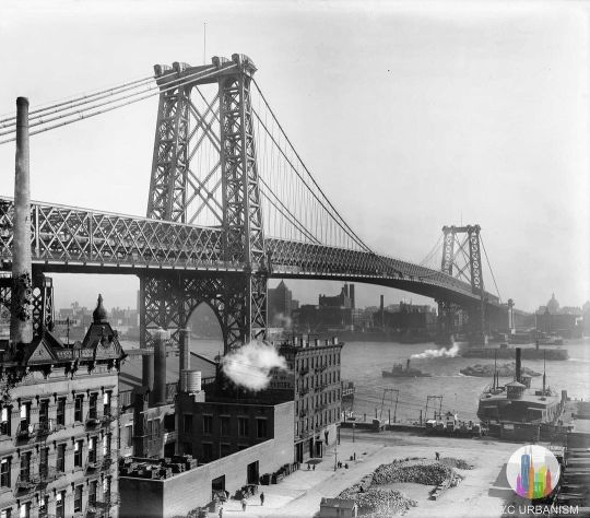
Williamsburg Bridge, 1903 The Williamsburg Bridge was the second bridge to span the East River following the Brooklyn Bridge almost two decades earlier and took half the time to build. By the time the bridge opened the independent city of Brooklyn had been consolidated into New York City. Compared to the neo-gothic towers of the #BrooklynBridge the public hated the steel towers of the Williamsburg Bridge when it opened. The 333-foot towers were originally designed to have a 140-foot tall spire atop each but were never constructed. The Bridge also featured a trolley terminal under #DelanceyStreet where streetcars going over the bridge would turn around. Streetcar service on the bridge was discontinued in 1948 and the terminal was shut down and lays abandoned to this day. The underground space was selected for the proposed #Lowline underground park, which features technology to reflect sunlight underground to grow plants. #williamsburg #brookyln #southwilliamsburg #nyc #dumbo #fortgreene #williamsburgbridge #manhattan #skyline #nychisory #nyhistory #urbanism #delanceystreet #brooklynbridge #manhattanbridge #nycphoto #eastriver #skyscraper #brooklynhistory #brooklynheights #nycurbanism (at Williamsburg Bridge) https://www.instagram.com/p/CgxJYYguUL3/?igshid=NGJjMDIxMWI=
#brooklynbridge#delanceystreet#lowline#williamsburg#brookyln#southwilliamsburg#nyc#dumbo#fortgreene#williamsburgbridge#manhattan#skyline#nychisory#nyhistory#urbanism#manhattanbridge#nycphoto#eastriver#skyscraper#brooklynhistory#brooklynheights#nycurbanism
45 notes
·
View notes
Photo
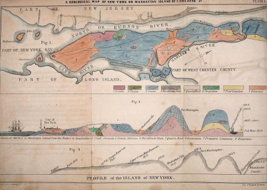
#MapMondays! Cozzens' 1843 Geological History of Manhattan or New York Island (top) and Profile of the Island of New York (bottom). Geologist Issachar Cozzens first published the map along with sections, tables and columns in 1843 for American students studying geology. Zoom into the map to view the colorful details. (at Tribeca) https://www.instagram.com/p/CgubJUnuQlC/?igshid=NGJjMDIxMWI=
6 notes
·
View notes
Photo
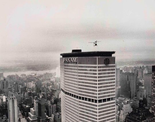
Helicopter passenger service on the roof of the Pan Am Building, 1964. The helipad operated from 1965 to 1968, allowing New Yorkers to fly right into midtown. It briefly reopened in 1977 but after a sideways landing killed five including one woman at street level who was struck by a rotor blade, the helipad was retired and company went out of business. 😳 #panam #panambuilding #metlifebuilding #chryslerbuilding #midtown #helicopter #nyc #midtownnyc #grandcentral #grandcentralterminal (at MetLife Building) https://www.instagram.com/p/CgXuNO2u-Yz/?igshid=NGJjMDIxMWI=
#panam#panambuilding#metlifebuilding#chryslerbuilding#midtown#helicopter#nyc#midtownnyc#grandcentral#grandcentralterminal
14 notes
·
View notes
Photo

This is truly an amazing photo: The Long Island Motor Parkway (AKA Vanderbilt Parkway) in 1908 with the Manhattan skyline in the background. Built in 1908 and running from Queens to Ronkonkoma, Long Island, historians have called it the first road in the country built specifically for automobiles. The privately built toll road featured overpasses and bridges with a toll of $2 when it opened – limiting the roadway for wealthy men wishing to race their new cars. The parkway was closed and absorbed by the state in 1938. Part of the trail still exists as a bike trail in Queens. #longislandhistory #brooklyn #longislandmotorparkway #longisland #brooklyn #robertmoses #vanderbiltparkway #longislandexpressway #lie #bqe #brooklynqueensexpressway #nyhistory #hychistory #urbanism #urbanplanning #thepowerbroker #architecture #urbandesign #cityplaning #urbanplanning #vanderbiltmansion #ronkonkoma (at Queens, New York) https://www.instagram.com/p/CfrN-ZKOFWz/?igshid=NGJjMDIxMWI=
#longislandhistory#brooklyn#longislandmotorparkway#longisland#robertmoses#vanderbiltparkway#longislandexpressway#lie#bqe#brooklynqueensexpressway#nyhistory#hychistory#urbanism#urbanplanning#thepowerbroker#architecture#urbandesign#cityplaning#vanderbiltmansion#ronkonkoma
28 notes
·
View notes
Photo
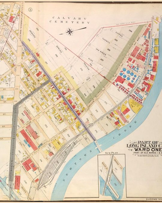
#MapMondays - Long Island City & Newtown Creek, 1907 A section of one of the custom maps one of our customers recently ordered Visit our website to order your own custom historic land map for any block in NYC (at Long Island City) https://www.instagram.com/p/CfUentNuDnV/?igshid=NGJjMDIxMWI=
7 notes
·
View notes