#hikingperu
Text
Hiking up Huayna Picchu from Machu Picchu // Ann Kruetzkamp
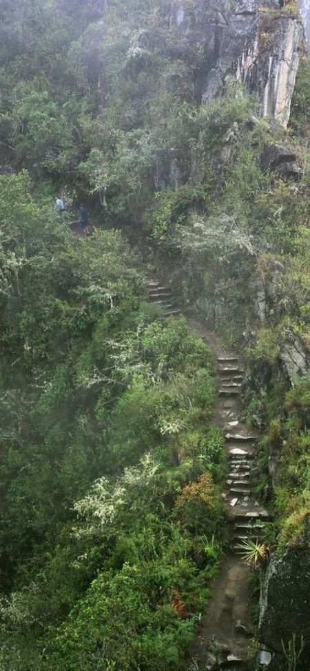
Step into the shoes of a confident explorer and embark on an epic hike up Huayna Picchu, an unforgettable journey with Ann Kruetzkamp.
0 notes
Photo

Hiking up Huayna Picchu from Machu Picchu // Ann Kruetzkamp
Step into the shoes of a confident explorer and embark on an epic hike up Huayna Picchu, an unforgettable journey with Ann Kruetzkamp.
1 note
·
View note
Photo
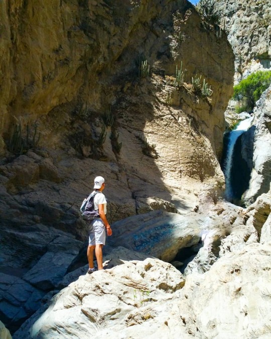
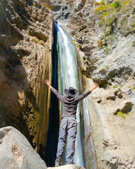
Agua bendita! Las cascadas de Sogay es uno de los atractivos más destacados de la zona de Yaramaba al suroeste de Arequipa. Sólo toma 1 hora en auto desde el centro de la Ciudad, donde se prosigue hasta el estacionamiento para continuar a pié pié por casi 1.5km a través del sendero. Hermoso lugar para pasar el día en relax ydarse un baño en sus pozas naturales! 😉😎✌💪 ================================ 📸 @rebemartinezdp 📌 Cascadas de Sogay, Yaramaba, Arequipa Perú. . . . #sogay #yarabamba #arequipa #relax #cascadas #excursion #relax #peru #travelperu #hiking #waterfall #nature #hikinglife #hikingperu #hiking #hikingculture #ctpperu #scapeland #igersarequipa #igersperu (en Cataratas De SOGAY) https://www.instagram.com/p/BoaYLQhhTWH/?utm_source=ig_tumblr_share&igshid=1johq3zc0nqsm
#sogay#yarabamba#arequipa#relax#cascadas#excursion#peru#travelperu#hiking#waterfall#nature#hikinglife#hikingperu#hikingculture#ctpperu#scapeland#igersarequipa#igersperu
1 note
·
View note
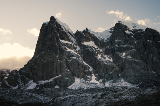
Photo
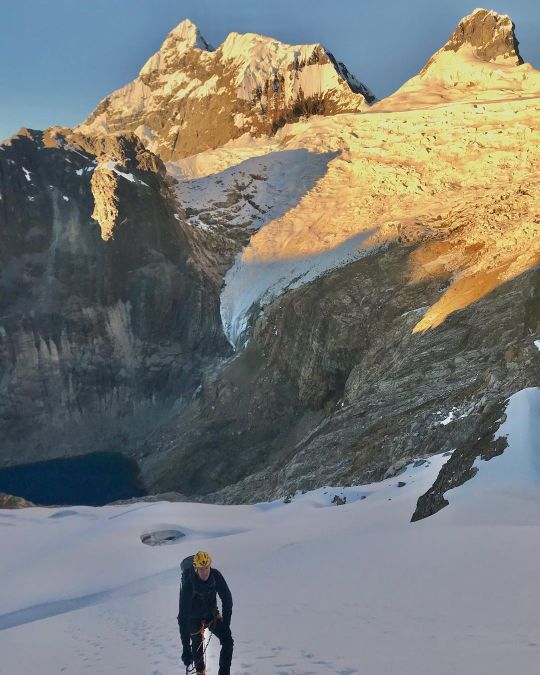
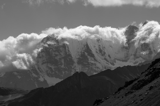
Maparaju glacier… behind the great Huantzan #cordillerablanca #peru🇵🇪 . . . . . . #mountain #visitperu #cametoperu #hikingperu #peruopaísmaisrico #montañeros #perutravel #montanha #montagne #alpsmountains #gopro #garmin #mountaineering #mountainsportscollective https://www.instagram.com/p/CSE2HjaMnsm/?utm_medium=tumblr
#cordillerablanca#peru🇵🇪#mountain#visitperu#cametoperu#hikingperu#peruopaísmaisrico#montañeros#perutravel#montanha#montagne#alpsmountains#gopro#garmin#mountaineering#mountainsportscollective
0 notes
Text
The Cordillera Huayhuash Circuit
I stumbled across the Cordillera Huayhuash circuit while looking for obscure hikes on the internet, someone out there in the ether compared it to hiking in the Himalayas and after a quick google-image-search of the trek I was sold. We hired a guide and donkeys, booked our tickets to Peru and we were off (ok, it was more work than that but to move the story along). Here’s overview/breakdown of the hike. If you are looking for facts to plan a trip there is a post here.
Basics:
Length: 97 miles (156 km)
Timeframe: 10 days
Acclimate: This hike is VERY high up and you need to acclimatize: we spent 3 days in the Cusco region and 1 day in Hauraz
Day 1: On August 23rd we got up at 4:30 am to start our bitterly cold, early morning journey into the mountains. It takes several hours of bus rides to arrive in Pocpa. The bus company was kind enough to provide us all blankets but it was frigid. If you get car sick from windy roads (like me) try to get a window seat. The hiking on the first day is pretty easy, gradual uphills mostly following a road. This is the only day with no high pass, so appreciate it. You get glimpses of the snow capped peaks and walk though some beautiful grazing land. This is the beginning of hiking through animal poop, you get used to it. The camp the first night is nice but they only get better. This was the only day I had issues with the altitude. I drank a lot of fluids, took an ibuprofen and went to bed early, that seemed to do the trick.
Hike time: 4 hours 30 minutes
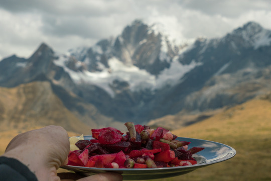
Day 2: This is the first real day of the hike and the first high pass you will cross. Be prepared for lots of switchbacks, it’s a slow and steady slog. My husband and I were alternating between not being able to imagine making it to day 10 and feeling like maybe we could do this. We had a great lunch on this day of Russian salad (below) and, after nearly 6 hours, we arrived at a beautiful campsite (view from tent below).
Hike time: 5 hours 45 minutes
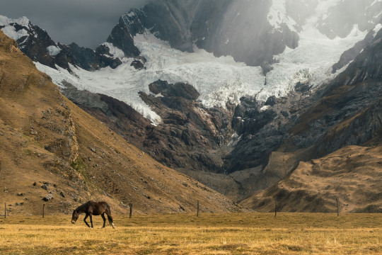
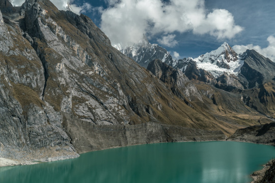
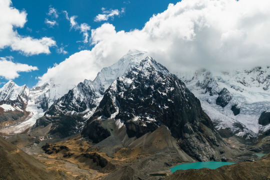
Day 3: Many more switchbacks today, the sky was cloudy so we did not go on what would have been our first side trip as the views were obscured. This made day three pretty short and easy for us. There are some great views as you near the campsite and the campsite itself was a stunner. The other 4-5 groups on the trail camped off to the side of Carhuacocha lake but we had our very own campsite right on the lake directly opposite snow capped peaks. This campsite alone was worth the cost of hiring guides.
Hike time: 4 hours 15 minutes
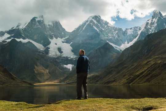
(view from tent)
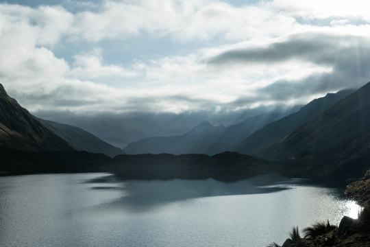
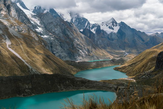
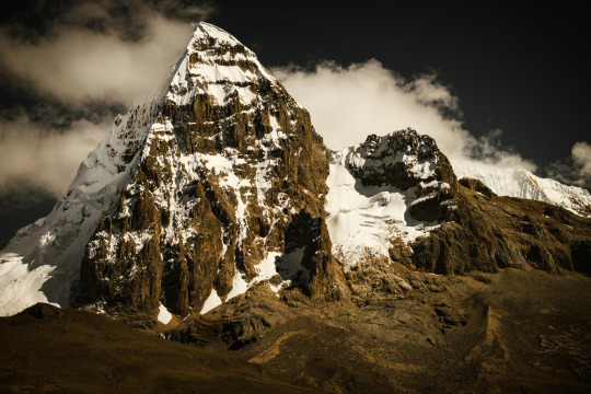
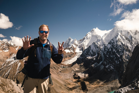
Day 4: Today was one of the most difficult days of the hike. We said goodbye to our beautiful campsite at 7:15 am and trekked down a valley leading us to our big pass for the day. On the way we dropped our packs and scaled a hill for a view of Sulla and Yerupaja peaks. It’s worth the climb for the beautiful views and we saw 4-5 avalanches which are cool to see but sad from an environmental standpoint. From there we hiked up a very difficult steep path to the most iconic view of the hike (the three lakes (below) ) shockingly to us, we weren’t yet at the pass which was another hour of grueling switchbacks. After the pass it was another 3 hours to camp. This day provided the scenery we were craving but it was an extremely strenuous day.
Hike time: 8 hours 45 minutes
Day 5: Day 5 is pretty chill. We trekked through these strange round moss formations as we made our way to yet another pass. Enroute we saw a huayhuash animal (something between a rabbit and a squirrel)! The pass today is not bad and when you finally arrive at camp you are treated to hot-springs! Also, there is a little shop that sells beer, snacks and toilet paper. The hot springs are AMAZING! Day five is heavenly.
Hike time: 5 hours 10 minutes
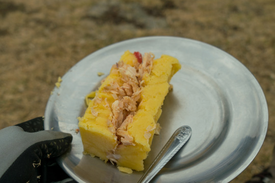
Day 6: Today we climbed what we thought was our highest pass at 16,568 feet (5050m) it was a very long steady climb up. We saw a condor and a Vicuña on the way! After we made it over the pass we stopped for a lunch of a Peruvian dish called causa which is basically meat and veggies sandwiched between two layers of mashed potatoes - great, hardy hiking food! After lunch the weather turned, it started to sleet we only had about an hour to camp I ran to catch up with Eric because he had my rain coat. I eventually caught him (mostly cause he turned around to come back for me) and we put our heads down and hightailed it to camp.
Hike time: 5 hours 45 minutes
Day 7: If you are the kind of person who hates hiking downhill, like my husband, this will likely be your least favorite day of the hike. It is a very long, difficult day but the views are world class. The day starts with very strenuous switchbacks in the snow up to the actual highest pass of the hike, the San Antonio Pass clocking in at a whopping 16,732 feet (5100m). You keep thinking you’re at the top of the pass, but you’re not, it’s a mental challenge. At this point in the trek I was regretting going on the trek, I felt miserable. Climbing this pass was so goddam hard! At the top though! Wow, what a view, it made it all worth it! On the flip side, all of this hard work is rewarded with 3 hours of climbing down steep, rocky terrain that brutalized my husband.
Hike time: 8 hours 45 minutes
(view from the top)
(view from the top)
Day 8: As long as I have pretty views I can deal with challenging hiking but ‘Dia Ocho’ is the worst! A long day, gradually uphill the whole way and short on pretty views. On day eight you start to leave the big peaks which is a bummer. To make it worse Eric woke up and his ankle was pretty injured from the previous day but our guide Samual soaked it, applied some magical balm our hiking mate Etta provided, and wrapped it up. He was a great guide and Eric was good to go.
Hike time: my husband didn’t note the time here but it was a long day. My guess is 8 hours
Day 9: Days 8, 9 and 10 are far less beautiful than the rest of the hike. It would be nice to hike it the other way around. Today starts with a hike up a pass right away. For dinner the night before I ate a rich, creamy pasta that did not sit right in my stomach. I woke up not feeling well and had to ride the horse over the pass which was a bummer but great at the same time. The view was not mind blowing but you still hike through some pretty peaks along the way to camp.
Hike time: 5 hours 30 minutes
Day 10: We were destroyed by day 10. Today there is an optional pass you can cross or you can take a flatter, longer route to the end. We chose the flat route. We were off at 6:30am and it was a nice easy walk. There was a lot of downhill as we made our way to Llamac. We could see the town far before we reached it which made the hike seem long. Eventually we reached the edge of the town and our Arriero and donkey’s. We sat on the curb waiting for our ride and cheering on hikers who were finishing. It felt good, we did it!
Hike Time: I have no idea, but not long, maybe 5 hours.
This hike is VERY strenuous. Part of the challenge is the altitude and part of it is sleeping in a tent for 10 days. The distances aren’t terribly far but it wipes you out. On the other hand, the views are spectacular! It’s such a gift in this world to let yourself get cut off from everything and everyone and simply experience a place and a landscape with no distractions. Also, the stars are ridiculous out there. Would I recommend it? If you’re in good shape, sure. I don’t think it’s the most beautiful hike I’ve ever done (Nepal wins there) but I do think it’s the most difficult hike I’ve done so that makes it a hard sell. Would I do it again? No, no way, but I wouldn’t trade the experience for anything. I got to experience the Peruvian Andes in a way most people will never get to and sometimes the hard challenges in life end up being the experiences we treasure the most.
If you’re planning to do this hike and want more details, I have another post here.
#cordillera#cordillerahuayhuash#cordillerahuayhuashcricuit#huayhuash#trekking#trek#trekkingperu#trekperu#peru#hike#hiking#hikeperu#hikingperu#travel#backpacking#tramping#travelblog#徒步旅行#Wandern
5 notes
·
View notes
Photo
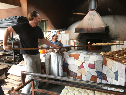
Day 3 of our @experiencemlp trek to Machu Picchu... 1. @whatsmikeeatingnow helped out a local bread maker. This may be the first time he’s used an oven since I��ve know him. 😹 2 & 3. We hiked up to the archeological site of #Ancasmarca. These round buildings were used as storage containers, high up in the mountains. 4. Then we toured a local market and bought more bread to distribute to the locals on our way to... 5. Hike from #Cuncani to #Huacahuasi where it rained almost non-stop, but the lakes were pretty and we were escorted by some awesome dogs. #experiencmlp #thehorowitzs #thedashanddineperu #marriedchristmasperu #peru #peruvian #hikingperu #incanruins #traveling #travelblogger #breadoven #workingdogs
#thehorowitzs#ancasmarca#marriedchristmasperu#incanruins#huacahuasi#traveling#travelblogger#breadoven#hikingperu#experiencmlp#cuncani#workingdogs#peru#thedashanddineperu#peruvian
0 notes
Photo
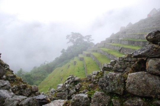
#tbt- Farmland, Machu Picchu, Peru.⠀ .⠀ .⠀ .⠀ .⠀ .⠀ .⠀ .⠀ .⠀ #travel #explore #costumedesign #costumedesigner #inspo #inspiration #traveler #passportexpress #passportready #welltravelled #costumedesigninspo #frequentflyer #southamerica #peru #pig #pigonthehill #farmland #machupicchu #hiking #hikingperu #photography #amateurphotograher #amateurphotography #mist #fog (at Machu Picchu, Cusco, Perú)
#passportready#hikingperu#inspo#farmland#amateurphotography#travel#mist#southamerica#photography#costumedesigninspo#explore#pigonthehill#frequentflyer#fog#inspiration#costumedesign#hiking#machupicchu#amateurphotograher#passportexpress#tbt#peru#welltravelled#pig#traveler#costumedesigner
0 notes
Text
Basic info on hiking the classic 10 Day Cordillera Huayhuash circuit
Swayed by beautiful pictures on the internet and the movie ‘Touching the Void’ (have you seen it? you should, it’s on Netflix and it’s great), my husband and I set off on August 23st to hike the 10 day Cordillera Huayhuash circuit in the Peruvian Andes. We chose the winter because it is supposed to be the driest time with the most consistent weather. The weather in August turned out to be quite cold in the mornings and evenings but really pleasant hiking weather during the day. We had snow on several nights. We chose to go with a guide and donkeys because we wanted a fighting chance of enjoying ourselves. Here are some of the basics. A day to day breakdown of the hike can be found here.
Distance: 97 miles (156 km)
Average Elevation: 14,100 feet (4300m)
Highest Point: Crossing the San Antonio Pass at 16,732 feet (5100m)
Typical Sleeping elevation: Between 12,795 feet - 14,100 feet (3900m-4300m)
Acclimating: We hail from Minnesota so we are what you would call lowlanders. Because of this we decided to kick off our trip in Cusco. We spent one night at Ollantaytambo (9000 ft) and the next two nights in Cusco (11,000 feet). We then made our way to Hauraz where we spent a fourth night acclimatizing at 10,000 feet. We didn’t do any acclimating hikes but we did make an effort to wander around all day everyday while we were up in the altitude. We also took prescription meds for altitude the day we left for Peru and the first two days in country. Did it help? I’m not sure. I felt the altitude the second we landed in Cusco but I felt pretty good so... maybe? Despite all this I did have a brutal headache the first day of the hike. I took some advil (bring advil) and went to bed. I was fine in the morning.
Guides: We chose Huascaran for two reasons; 1. They were reasonably priced 2. They had availability when we wanted to go. We were really happy with our choice. The point of contact, Paulino, is a wonderful man. He answered SO MANY emails that we sent him. We changed our dates 3 times and he rolled with the punches always being kind and accommodating. He also takes care of you from the moment you arrive in Hauraz to the day your trek ends when he invites you back to the office for homemade Pisco Sours and the musical stylings of the BeeGees. Our Guide, Samuel, was really great as well. Note that he spoke very little English. He was a truly phenomenal cook and a very slow, steady walker... he was just our speed. We were worried we might not get enough food on the hike but Samuel provided an abundance of food. Every morning we were woken with hot tea brought to our tent followed by a hot breakfast and a bag of snacks for the day. We had really tasty, filling lunches on the trail, a snack when we got back to camp and a two course dinner every night. You will not go hungry with this outfit. I have done some big hikes such as the Laugavegur, Annapurna, Gokyo Lakes, Julian Alps... and this was the most challenging even with our gear on the donkeys. I recommend guides if you’re considering it. Initially, to avoid a crowd, my husband and I signed on for a private guide . In time we decided to open up our trip to the general public and one other person joined us, decreasing the price significantly.
Packing: Here is what I brought on the hike:
5 pairs underwear (get hiking underwear!)
7 pairs hiking socks
3 pairs of hiking pants
3 wicking base layer tanks
1 wicking base layer t-shirt
2 sports bras (never wore them)
1 long underwear top
1 heavy long underwear bottom
1 very light fleece/jacket thing
1 heavy fleece
1 long sleeve button down hiking shirt (wore only once)
1 short sleeve button down hiking shirt (never wore it)
1 big thick hoodie for the camp (I wore this but didn’t really NEED it)
1 heavy winter coat
1 rain coat
1 winter hat
1 pair of thin gloves
1 pair of thick mittens (never wore them)
1 pair of pants to sleep in
1 pair hiking boots
1 pair tennis shoes
hiking poles
bug spray (never used)
sun block
hiking hat (wore once)
headbands/hair binders
toilet paper
tooth brush/paste
lotion
iphone
extra battery
solar charger
nice camera (sony a7rii)
tripod
1 daypack (a 24 liter pack it was a little small but it worked - this one)
1 camelbak
(my husband brought a water filter, not necessary but it was nice to have along)
Here is what I wish I had brought in addition:
a thin pair of long underwear bottoms (mine were too thick for cold morning hiking, a thin pair would have been nice)
an additional long underwear top. (I wore my thermals a lot! I could have used several pairs)
sandals would have been nice for camp
Costs:
Guide and Donkeys: $660.00 (we got this price when someone else joined our trip, it is substantially more expensive to go with just two people (around $128/day)
Entrance fee: 120 soles ($37/per person)
Fees: You pay fees for every campsite you stay at on this trek I don’t remember the exact amount but I believe it was around 300 soles ($100/per person)
Tips: The suggested amount to tip the guide and the donkey driver 300 soles ($100) for both, we gave more, these people do so much for you it’s hard to not want to give a higher amount.
For a day to day breakdown of the actual hike follow this link
#cordillerahuayhuash#huayhuash#cordillera#peru#peruvianandes#theandes#trekking#trekkingperu#trekperu#hikingperu#hikeperu#hike#hiking#travel#backpacking
3 notes
·
View notes
Photo
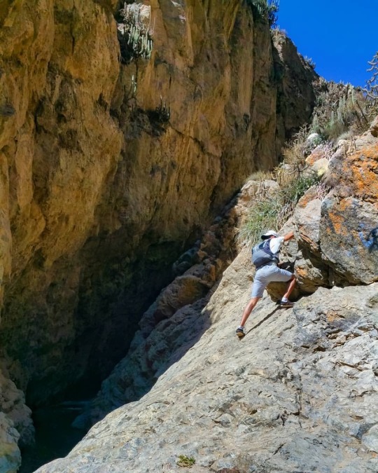
Sube hasta la cima así escupas un pulmón. 😆😎✌ ================================ 📸 @jacobmpw 📌 Sitio Arqueológico de Pillo, Socabaya, Arequipa, Perú . . . . #arequipa #hikinglife #hikingadventure #hikingculture #hikingperu #runmountains #igersperu #peru #earthoutdoors #outside_project #adventureenthusiastsco #peruen360 #igersarequipa (en Socabaya, Arequipa, Peru) https://www.instagram.com/p/BpcLVtiH88E/?utm_source=ig_tumblr_share&igshid=1390na38vixw3
#arequipa#hikinglife#hikingadventure#hikingculture#hikingperu#runmountains#igersperu#peru#earthoutdoors#outside_project#adventureenthusiastsco#peruen360#igersarequipa
0 notes
Photo
Si de las cascadas quieres gozar, primero debes trepar! 💪😎✌ ================================ 📸 @mariana_martinezdepinillos 📌 cascadas de Sogay, Yarabamba, Arequipa, Perú . . . #arequipa #peru #hikingperu #igersarequipa #igersperu (en Yarabamba, Arequipa, Peru) https://www.instagram.com/p/Bo4i4vhBonV/?utm_source=ig_tumblr_share&igshid=16zlwm6vv3fyi
0 notes
Photo
Recibe lo bueno de esta tierra, solo basta salir e ir donde más te guste. 😉😎✌👍 ================================ 📸 @ingcarol89 📌 cascada de Ccapua, Yura Viejo, Arequipa-Perú ================================ #yura #arequipa #senderismo #hiking #hikinglife #hikingperu #promperu #hikingculture #hikingforlife #nature #cascada #agua #waterfall #naturaleza #relax #adventure #hikingadventure #relax (en Cataratas De Capua - Yura) https://www.instagram.com/p/BncHqvNgPrN/?utm_source=ig_tumblr_share&igshid=zvf202xbvitx
#yura#arequipa#senderismo#hiking#hikinglife#hikingperu#promperu#hikingculture#hikingforlife#nature#cascada#agua#waterfall#naturaleza#relax#adventure#hikingadventure
0 notes
Photo
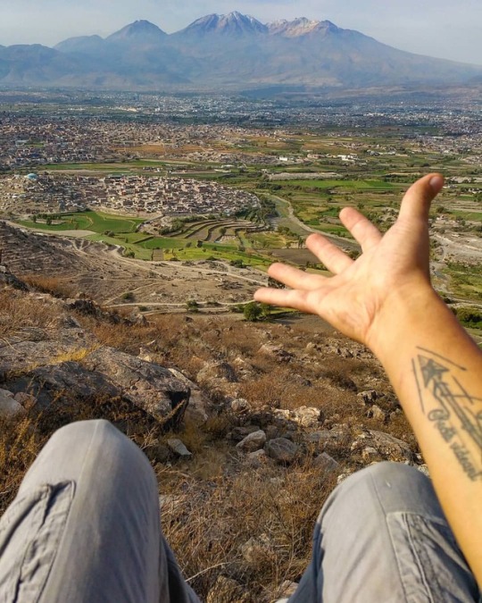
Solo en Arequipa puedes disfrutar de esta y otras vistas. El volcán Chachani con 6052 msnm se impone sobre la ciudad al igual que el Misti y el Pichu Pichu. ========================= 📸 @jacobmpw 📌 Socabaya, Arequipa, Perú . . . . #igersarequipa #hikingperu #outside_project #igersperu #earthoutdoors #hikingculture #lovemountains #adventureenthusiasts #adventure #peru #arequipa (en Arequipa Region) https://www.instagram.com/p/BrYZTQdnCuQ/?utm_source=ig_tumblr_share&igshid=1cps06o6phedu
#igersarequipa#hikingperu#outside_project#igersperu#earthoutdoors#hikingculture#lovemountains#adventureenthusiasts#adventure#peru#arequipa
0 notes
Last Seen Blogs

starpowerdeepwater
star

ohgerard
oh gerard

adhd-pro
Natural Born Sinner

ruwenkissy
Kissy如吻内衣

becausestuff
Oh Sweet Hash