#Meradalir volcano
Text

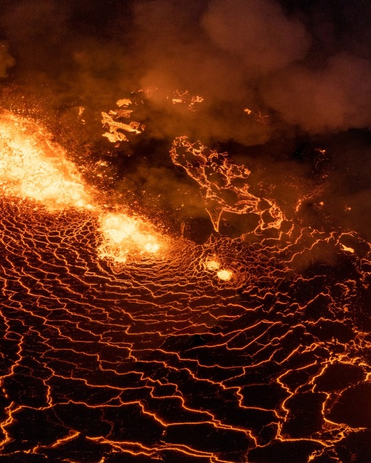

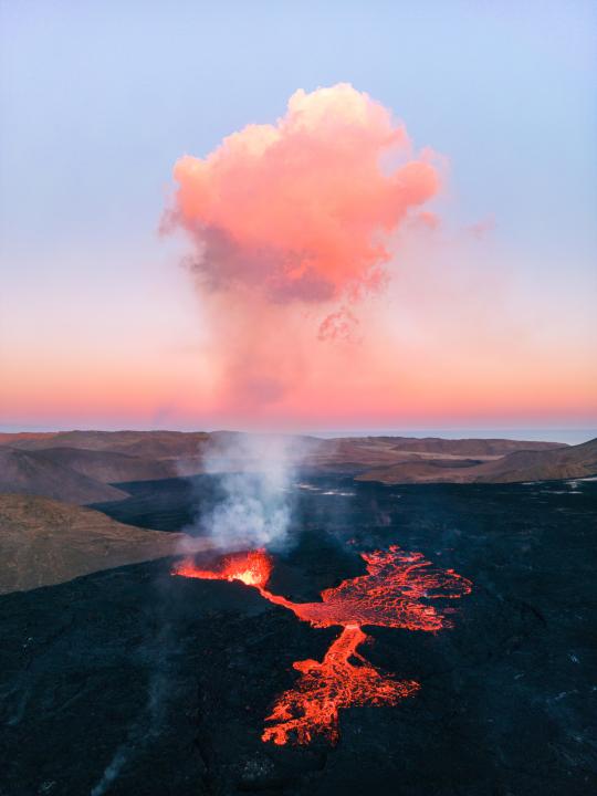
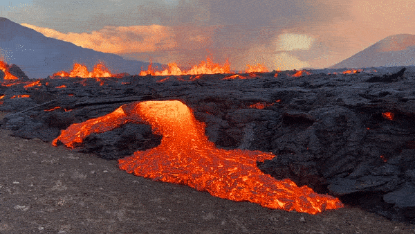
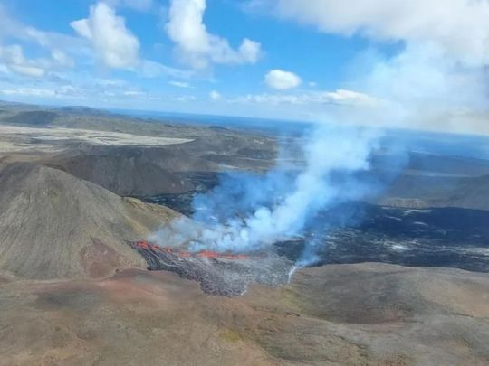
" Meradalir Eruption " //© jvn.photo
#Meradalir#Iceland#nature#landscape#Volcano#Eruption#Lava#aesthetics#wanderlust#explore#follow#discover
156 notes
·
View notes
Text
The Meradalir eruption 🔥 !.
#Geldingadalur valley#iceland#Volcano#Eruption#Magic#Lava#downfall#downfalldestiny#The Meradalir#beautiful places#beautiful destinations#destination#Voyage
286 notes
·
View notes
Text
#life#lifestyle#travel#explore#sand#ocean#lake#water#northern lights#china#ruyi bridge#pink beach#diamond beach#iceland canyons#volcano meradalir#cocoa beach#haoyang lake#knik alaska#twilight park#las huasteca#exuma beach#santa catarina#trolltunga#village reine#lapland
14 notes
·
View notes
Text
Arrival to Keflavík · Lost luggage · Birth of the Meradalir volcano · Night in Akranes
4th of August, 2022
After a long flight with two transfers - a busy night spent on Stockholm airport, early breakfast for two (= shared Norwegian beer) and enjoying the sight of a beautiful landscape after departing from airport in Oslo, we finally arrived to Keflavík - only to find out, that one of our backpacks was left back in Stockholm. Knowing, that we have time until the evening for the luggage to arrive, we decided to pick up our rented car and explore the surroundings. As we didn't have an exact plan for our first day in Iceland, our best option was to stay in a close proximity to Keflavík airport. And how damn lucky we were! Only one day has passed since the birth of the Meradalir volcano, and the starting point for the hike was only 30 minutes away from the airport.

Spectacular view of the solidified lava fields from previous eruptions in Geldingadalir, photo taken at the starting point of Route A to Meradalir volcano.
The hike to the volcano itself took us approximately 2 hours of leisurely walking. Vast area of the Fagradsfjall volcanic system was constantly monitored closely by scientists. We watched the volcano from a safe distance from above, nevertheless it was an experience of a lifetime. Later we noticed quite a lot of people in considerable proximity to the volcano and we considered returning back and going closer to the fissure at the end of our trip. Unfortunately, we were unable to do so due to time constraints.

Meradalir eruption, second day (4th of August, 2022).
After this unforgettable hike, it was almost time to get our lost luggage. On our way to Keflavík airport, we made short stops on the south coast of Reykjanes peninsula to observe a few swimming seals and we also took a peek at the Gunnuhver hot springs. First Icelandic word of the day was „hætta“ - danger. One has to be careful around all that lava, geothermal hot springs and pools. But the views are definitely worth it :)
We decided to spend our first night in a camp in the town of Akranes. We managed to watch the eye-flattering sunset, although the sun barely sets and the night is never completely dark in August. If you have to watch your budget, the best option is to buy a camping card at a very favorable price, which gives you access to several camping sites all over Iceland.

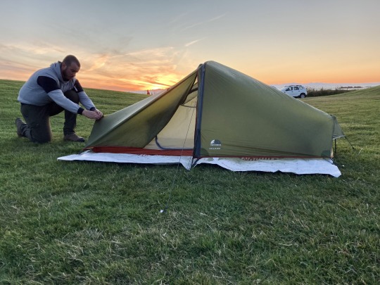
First night at the Akranes camping site, which was one of our favourites, as it offers great facilities and amazing seaview.
2 notes
·
View notes
Photo

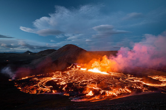
Photography By Niks Freimanis, Latvia.
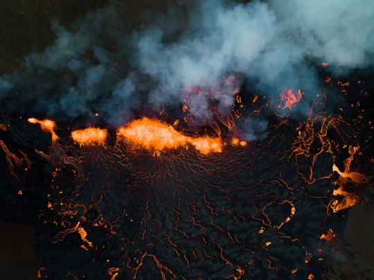
The second night of a volcanic eruption in the Meradalir valley, Iceland, which began in early August 2022.
Courtesy: The World Photography Organization
#art#photography#iceland#volcano#eruption#fire#flames#niks freimanis#latvia#meradalir valley#earth#wildlife#sony world photography awards
4 notes
·
View notes
Text
I haven't done this in a while, but - things have been quiet on the seismic activity front since the eruption at fagradalsfjall/meradalir last year! It's been pretty standard, 100-200 earthquakes most days, and all the volcanoes are on green colour codes. So it's been quiet! Here's today's report - the green stars are quakes above a magnitude 3 (in this case, 3,3 and 3,2). I think Fannar is happy for this lull o(--(

4 notes
·
View notes
Photo
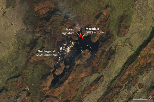
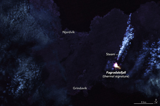
Eruption in Fagradalsfjall, Iceland On August 3, 2022, a new volcanic eruption began in the Fagradalsfjall fissure zone on Iceland’s Reykjanes Peninsula. The eruption site in the Meradalir Valley is about a kilometer northeast of last year’s eruption in the Geldingadalir Valley. The recent eruptions come after an 870-year quiet period in the Krýsuvík–Trölladyngja volcanic system. This volcanic system is composed of two groups of fissures or swarms, named Fagradalsfjall and Krýsuvík. The fissures trend northeast-southwest for 50 kilometers (30 miles) in the rift zone where the North American and Eurasian plates are moving apart, according to the Catalogue of Icelandic Volcanoes. Starting in early August, the Meradalir eruption emitted fountains of lava along a 300-meter (1,000-foot) segment of the fissure. The brilliant display attracted crowds of tourists, who hiked in to see the slow-moving basaltic lava as it flowed east-northeast. Iceland’s Institute of Earth Science estimated that 10.6 million cubic meters (14 million cubic yards) of lava had covered an area of 1.25 square kilometers (0.5 square miles) by August 15. Early on, the eruption was emitting lava at a rate of up to 32 cubic meters (40 cubic yards) per second, which soon slowed to an average of 11 cubic meters per second. By August 16, the Meradalir eruption rate had dropped to 2 cubic meters (3 cubic yards) per second. The March 2021 eruption in Geldingadalir issued 5 to 10 cubic meters (7 to 13 cubic yards) of lava per second during its first three weeks. The first image above was acquired on August 16, 2022, by the Operational Land Imager (OLI) on Landsat 8. The image includes a combination of visible and infrared light (bands 6-5-3), which helps distinguish the heat signature of the lava. The second image also shows the thermal infrared signature of the lava flow, but at night. It was acquired on August 7, 2022, with OLI and the Thermal Infrared Sensor (TIRS) on Landsat 8. According to the Catalogue of Icelandic Volcanoes, the Krýsuvík-Trölladyngja system has been "moderately active" during the Holocene Epoch. At least 10 eruptions, lasting from a few years to decades, have occurred over the past 8,000 years. This suggests an eruption interval of 400 to 1,000 years, with an average of more than 750 years. The last significant eruption before 2021 happened in the 12th century, when four lava flows ejected 220 million cubic meters (287 million cubic yards) of lava. The molten rock covered more than 36 square kilometers (14 square miles) and reached the north and south coasts of the Reykjanes Peninsula. NASA Earth Observatory images by Lauren Dauphin and Joshua Stevens, using Landsat data from the U.S. Geological Survey. Story by Sara E. Pratt.
7 notes
·
View notes
Photo
The erupting volcano at sunset in Meradalir, Iceland [OC][6048x8064]
6 notes
·
View notes
Text
Iceland Eruption May be the Start of Decades of Volcanic Activity
A second outburst of lava in under a year strongly suggests that the country’s Reykjanes Peninsula will become one of the most volcanically dynamic parts of the planet for several generations.
— By Robin George Andrews | Photographs By Chris Burkard | August 04, 2022
After centuries of quiescence, Iceland's Reykjanes Peninsula has erupted twice in less than a year, sending up fountains of incandescent rock. The latest eruption, which started at 1:18 p.m. local time on August 3, opened up at a fissure only a few hundred feet away from the cone crafted by last year’s volcanic outburst.
Less than a year has passed since lava stopped sputtering from Iceland’s Reykjanes Peninsula following the first major volcanic outburst from this region in almost 800 years. But now the island is once again bleeding molten rock. The start of a new eruption so soon after unrest in 2021 seems to underscore that this once quiescent peninsula has awoken from its long slumber.
“This could herald the start of decades of occasional eruptions,” says Dave McGarvie, a volcanologist at Lancaster University.
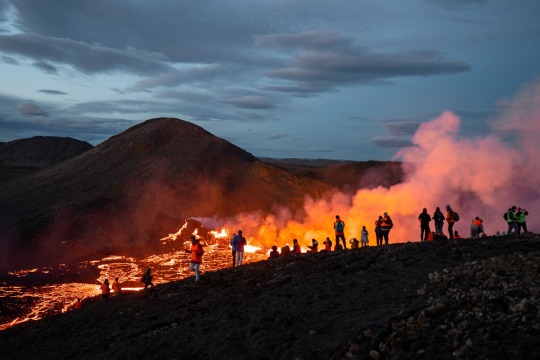
Crowds have already gathered to take in the stunning scenes, watching Earth forge new landscapes.
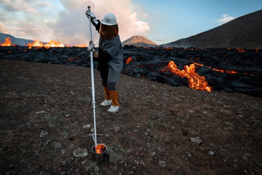
While the flashes of scarlet were just spotted yesterday, scientists are already busy collecting their first samples of rock, including volcanologist Helga Kristin, shown here.
The new eruption, which started at 1:18 p.m. local time on August 3, sent scarlet ribbons streaming from the base of a small mountain into the uninhabited Meradalir Valley. Located far from populations, the volcanic burbles likely pose little danger to the public, at least in the near term. And this relative safety allows scientists and tourists alike to marvel at the geologic majesty and get excited for a possible onslaught of new scientific knowledge.
After all, each volcanic eruption here provides a “window into the abyss,” McGarvie says. The 2021 event yielded revelations about the personality of the peninsula’s exuberant eruptions—from their physical behaviors to their quirky chemistries. This new eruption promises even more insights as the nascent volcano forges the world’s youngest land.
It’s still unclear how prolific or lengthy the eruption will be; this information will only come to light with more time and continued monitoring. But this week’s show of fireworks strongly hints the peninsula will become one of the most volcanically active parts of the planet for several generations.
“I am genuinely excited,” McGarvie says.
A Volcanic Double-bill
The Reykjanes Peninsula lies about 17 miles southwest of Iceland’s capital city Reykjavik. It sits atop the continually spreading Mid-Atlantic Ridge, where the North American plate to the west and the Eurasian plate to the east are gradually pulling apart. Superhot, gassy magma, which is less dense than the surrounding rock, can sometimes rise into the shallow crust from buoyancy alone, but all that regional stretching also creates cracks where molten rock can infiltrate.
The peninsula’s subterranean bedlam seems to manifest as periodic busts of volcanism. Historical accounts and studies of ancient volcanic rocks show that times of volcanic repose transition into loud seismic and eruptive awakenings in a cycle that’s transpired several times in the past few millennia.
While the flashes of scarlet were just spotted yesterday, scientists are already busy collecting their first samples of the rock, including volcanologist Helga Kristin, shown here (top). Seen below, crowds have also gathered to take in the stunning scenes, watching Earth forge new landscapes.
Although the region had been volcanically dormant for centuries, the tectonic sundering happening in the depths meant that last year’s eruption had long been in the works. And in recent years, several sheets of magma ascended toward the surface, indicated by the changing shape of the ground and swarms of earthquakes, says Tobias Dürig, a volcanologist at the University of Iceland. But for some time, these magmatic serpents failed to see sunlight—their escape was stymied either from the loss of their own upward momentum or because the resilient crust didn’t offer an escape hatch.
Nevertheless, as earthquakes began to crescendo in both frequency and strength from late 2019 onwards, scientists suspected that an eruption sometime in the future seemed inevitable. That was confirmed in dramatic fashion on March 19, 2021, when lava began gushing from a 1,650-foot-long fissure in a valley of the Geldingadalur region. Hundreds of thousands of visitors flocked to the region to watch that eruption, which built a vertiginous cone of magmatic splatter as it erupted over six months, causing no damage to infrastructure and no casualties.
Then, since late July of this year, another cacophony of quakes and significant ground deformation plagued the region, pointing to the upward incursion of yet another magmatic sheet, according to the Icelandic Meteorological Service.
On July 31 a bone-rattling magntiude-5.5 earthquake struck the peninsula. This and other powerful temblors prior to the latest volcanic flare-up may have been so-called trigger earthquakes, says McGarvie. Stress builds as the intrusion of magma stretches the crust, until it fractures with a mighty jolt.
By August 2 magma was sitting just half a mile below the surface. Yet that same day the seismic activity and the ground deformation seemed to decline. Although this could suggest that the magma had more-or-less stopped in its tracks, this sequence of events also resembled the same pattern observed just before the 2021 eruption, which was the country’s longest in 50 years. Iceland’s uppermost crust can often stretch like a rubber band, accommodating magma without loudly cracking apart. So the most recent quietening may have been a precursor to an eruption—the calm before the magmatic storm.
On the other hand, there have been similar rises and falls in seismicity on the peninsula that did not end in eruptions, says Tom Winder, a volcano seismologist at the University of Cambridge. Further investigation is necessary to determine whether this pattern of sudden seismic silence is a reliable warning sign.
Still, by August 2 the available data led the Icelandic Meteorological Office to declare that the possibility of an eruption was “considered to be substantial.”
Just one day later, lava fountains screamed skyward from a fissure only a few hundred feet away from the cone crafted by last year’s eruption.
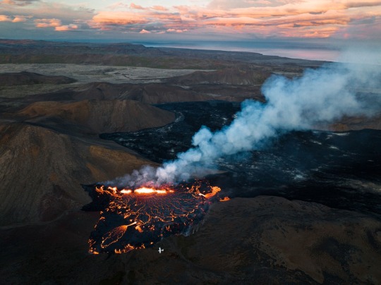
The incandescent rock is erupting with greater vigor than last year's outburst, but what the volcano will do in the days ahead—including how long this eruption will last—remains unknown. A small plane at the bottom of this image illustrates the scale of the new eruption.
The Land of Future Fires
Like its predecessor, the new eruption will likely pose little hazard to humans. The flows are currently confined to a series of empty valleys, with no major infrastructure nearby. Also absent are bodies of water or ice, which can sometimes trigger a series of violent, ash-heavy explosions. This is all good news for the region’s residents, particularly in the nearby fishing town of Grindavík that’s been riddled with quakes. Now that the eruption has started, the disruptive seismic shaking has all but vanished.
“It's still early days, but it looks like the eruption will be similar to 2021,” says Evgenia Ilyinskaya, a volcanologist at the University of Leeds.
But similar doesn’t mean identical. Per local media reports, the lava is currently flowing with more vigor than it did during last year’s event. That could either mean the valley quickly fills up, or that the eruption could more rapidly run out of fuel, leading to a much faster end.
It’s extremely difficult to forecast how long the eruption will continue or how much lava it can produce. Ground deformation reveals the volume of magma available to feed the eruption in the short term, but it says nothing about additional surges that may arrive from below in the days to come. Will the lava remain confined to these valleys, or will it travel further afield? Will it reach the sea and produce pernicious plumes of noxious gas?
“It is a bit like watching the first hours of a Tour de France stage and trying to predict from that the future winner of the yellow jersey,” Dürig says. In this instance, though, he expects the eruption to follow a similar pattern to that of 2021’s magmatic showcase.
If this is indeed the start of a new era of Reykjanes volcanism, it’s difficult to predict what this may mean for those who live on the peninsula, and it’s currently impossible to say where—or when—the next eruption may emerge. Not every new eruption will necessarily lie far from population centers or vital infrastructure. Some might differ in style to the recent pair. Multiple eruptions might even happen at once. Scientists can extract only so much information from ancient volcanic rocks, the oldest of which are often buried under younger flows.
“Surprises are to be expected,” McGarvie says.
Regardless, these ferocious fires ultimately benefit everyone: They are gifting scientists with an unparalleled look at the connective tissue between the igneous abyss below and the lava-licked landscape above. Their efforts help improve our understanding of Earth’s viscera, of Iceland’s volcanic cadence, and of this peninsula’s volcanic dangers.
“Here, we have a fantastic natural experiment,” says Ilyinskaya. “It will for sure lead to many scientific discoveries.”
The sputtering lava has already begun building small mounds of spatter near the fissure and filling the valley with a pool of molten rock. It’s unclear for now if the lava will remain confined to these valleys or will travel further afield, perhaps reaching the sea. But for now, says Evgenia Ilyinskaya, a volcanologist at the University of Leeds, the eruption is providing scientists with “a fantastic natural experiment.”
2 notes
·
View notes

Video
“ Visions of New Earth “ // © Chris Burkard for NatGeo
Music: Earthrise - Jason Creasey
#Meradalir#Iceland#nature#landscape#volcano#eruption#lava#flow#4K#8K#fpv#aesthetics#wanderlust#explore#follow#discover
202 notes
·
View notes
Text
[ad_1]
In 2021 Fagradalsfjall Volcano burst into life, red hot lava spewing from its crater. In August 2022 a new fissure in the Meradalir valley split open and it began erupting again. Here’s how to see it.
On Friday, March 19, 2021, at around 8:45 pm, the volcanic area around Fagradalsfjall in southwest Iceland burst into life.
Molten lava was thrown spectacularly into the air creating a red-yellow sky that could be seen from Reykjavík, 30 miles away.
As the lava cooled, it left behind a volcanic scar sweeping throughout the valley.
On August 3, 2022, at 1:18 pm Fagradalsfjall Volcano erupted again. A fissure just east of the volcano, in the Meradalir Valley, split open and plumes of molten lava were forced into the air.
Scientists rushed to the eruption site to assess the area and it was declared safe enough to open to visitors on the morning of Tuesday, August, 9.
Erruptions are the site are now relatively frequent. But the site is still a great place to visit with interesting hikes to fantastic viewpoints.
COMMENTS // We do our best to keep the information in this guide up to date, if you notice anything has changed, please leave a comment below.
BOOKINGS // Booking your trip via the links in this guide will earn us a small commission, at no extra cost to you. Thanks for your support – Paul & Mark.
The 2022 eruption at Fagradalsfjall Volcano – photo credit: handluggageonly.co.uk
FACTS ABOUT FAGRADALSFJALL VOLCANO
Fagradalsfjall is a flat-topped, steep-sided volcano in the Reykjanes peninsula in the southwest of Iceland. It is at the heart of a wider volcanic system (also referred to as Fagradalsfjall) which covers an area 5 kilometres wide and 16 kilometres long.
The volcano was formed in the last ice age but remained dormant for over 800 years until a fissure vent opened in Geldingadalir just to the south of Fagradalsfjall mountain on March 19, 2021.
Magma was thrown into the air and rivers of molten lava flowed round the mountains and through the valleys.
The magma was ejected at over 1,300°C (2372°F) and as it cooled, it left behind a volcanic scar; a sweeping river of black, suspended in place as it settled throughout the valley. On September 18, 2021 the eruption ceased but not for long.
On August 3, 2022, Fagradalsfjall Volcano erupted again. A 300-metre-long fissure opened up in the Meradalir Valley, just east of the previous eruption.
Plumes of molten magma were forced from beneath the ground and new rivers of molten lava flowed down the valley. For a couple of days, the eruption site was checked by scientists then opened to visitors again on the morning of Tuesday, August, 9.
Within days new paths had formed to viewpoints overlooking the eruption site and tours began running to the area.
TOURS TO MERADALIR & FAGRADALSFJALL
Tours to the Meradalir fissure at Fagradalsfjall Volcano are a great way to see the site, especially if you are not driving in Iceland. Most offer a pickup from hotels in Reykjavík and take 6 to 8 hours, including transport to the area and a guided hike to the viewpoint.
GETTING TO THE FAGRADALSFJALL VOLCANO
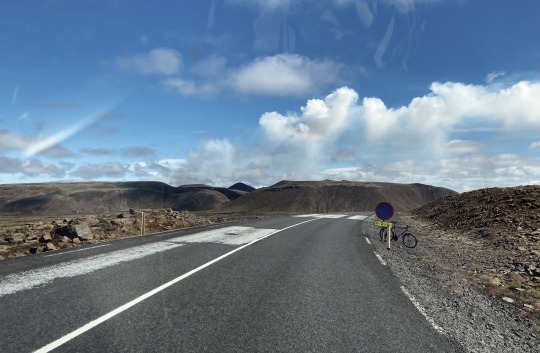
If you want to visit Fagradalsfjall Volcano under your own steam it is a 45-minute drive from Keflavik airport or 1 hour from Iceland’s capital, Reykjavík.
To get views of the volcano you will need to hike between 30 minutes to 2 hours (each way) on mountain trails to a series of viewpoints.
There are five different viewpoints over Fagradalsfjall Volcano: Stórhóll viewpoint, Meradalir Fissure Viewpoint, Nátthagi viewpoint, Langihryggur viewpoint, and Stóri Hrútur viewpoint.
PARKING AT FAGRADALSJALL
There are two car parks at Fagradalsfjall (open 24 hours a day). Payment is via the Parka.is app via credit or debit card. Cash is not accepted.
If you don’t have service, you can pay for the parking once you get back to your hotel and connect to the WiFI. You have 24 hours to pay for the parking once you leave the site.
PARKING COSTS
VEHICLECOSTPassenger Car1,000 ISKSmall Bus2,000 ISKBus4,000 ISK
PAY FOR PARKING
P1 & P3 – parka.is/pay/geldingadalir
P2 & P4 – parka.is/pay/volcanoskali
HIKES TO THE FAGRADALSFJALL VOLCANO VIEWPOINTS
There used to be a series of trails marked A, B or C which circumnavigated the Fagradalsfjall Volcano. However, the authorities have now closed these paths and redirected them to a new series of hiking trails around Fagradalsfall.
There are now 5 viewpoints to hike to at Fagradalsfjall, each giving a unique view of the 2021 and 2022 eruption sites.
1 – STÓRHÓLL VIEWPOINT HIKE
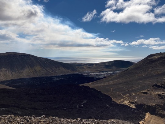
Stórhóll viewpoint gets closest to the black volcanic crater of the 2021 eruption at Geldingadalir. The trail to the viewpoint (Route A) passes right next to its cooled black lava flow and the black and yellow sulphurous crater can be seen about a kilometre away.
Below, the black lava field still steams from the residual heat. But to get to see the new eruption site you’ll need to head a bit further.
STÓRHÓLL HIKE DETAILS
Closest Park – Car Park 1 | Walking Distance – 2.6 kilometres | Time – 1 hour one way | Difficulty – Easy to medium with 150 metres of ascent
2 – MERADALIR FISSURE VIEWPOINT HIKE
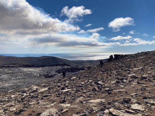
Meradalir Fissure viewpoint is 3 kilometres past the Stórhóll viewpoint and is the closest viewpoint to the 2022 eruption site. This the viewpoint to go to for the best views of the new eruption, the fissure is only about 500 meters away.
The eruption is changing on an almost daily basis, the best idea of what you can see from here is from the Langhöll webcam which is positioned on the mountain just behind the viewpoint. But standing here and watching the eruption is breathtaking.
A rough route of the new trail to the viewpoint (an extension to Route A) is provided on the map at the end of the post. Being a new route the path is rough and rocky so wear some shoes with a good grip. It takes about 4 hours to make the round trip walk. Adding an hour to take photos, plan on at least 5 hours for the round trip.
MERADALIR FISSURE HIKE DETAILS
Closest Park – Car Park 1 | Walking Distance – 5.6 kilometres | Time – 2 hours one way | Difficulty – Medium with 200 metres of ascent
3 – NÁTTHAGI VIEWPOINT HIKE
Nátthagi viewpoint is right at the end of the lava flow that was created in the 2021 eruption.
Here you can get up close to the rounded glob of solid black lava at the point where it stopped flowing towards the bottom of the valley. It gives the best impression of how the lava flow solidified and came to a stop.
Although the lava is within touching distance, you are not allowed on the lava as sulphurous gases can still escape.
NÁTTHAGI HIKE DETAILS
Closest Park – Car Park 2 | Distance – 800 metres | Time – 15 minutes one way | Difficulty – Easy with 30 metres of ascent
4 – LANGIHRYGGUR VIEWPOINT HIKE
Langihryggur viewpoint is at the summit of Langihryggur mountain; a dramatic 296-meter-high ridge. It is higher than the previous two viewpoints and offers a tremendous overview of the entire area.
From here you get the best overall impression of the whole site including the path the lava took from the 2021 eruption as it swept over the mountains and down through the valleys.
The 2022 eruption can also be seen from Langihryggur viewpoint although it is about 2.5 kilometres away. To get closer to the Meradalir fissure head further along the ridge to Stóri Hrútur.
LANGIHRYGGUR HIKE DETAILS
Closest Park – Car Park 2 | Distance – 2.5 kilometres | Time – 1 hour one way | Difficulty – Medium with 250 metres of ascent
5 – STÓRI HRÚTUR VIEWPOINT HIKE
Stóri Hrútur viewpoint is on top of Stóri Hrútur mountain (353 metres) and just over 1 kilometre further along the ridge from Langihryggur.
Higher and with steeper sides, Stóri Hrútur is only 1.5 kilometres away from the 2022 fissure eruption in the Meradalir Valley.
There is a steep and often slippery and tricky zig-zag path heading up its slope. An easier path heads around the base of the mountain staying closer to the 2021 lava flow and giving you a lower view over the new eruption.
Depending on conditions you can choose which route to take from the top of Langihryggur.
STÓRI HRÚTUR HIKE DETAILS
Closest Park – Car Park 2 | Distance – 4 kilometres | Time – 1 hour 40 minutes one way | Difficulty – Medium – Challenging with 370 metres of ascent
MAP | FAGRADALSFJALL VOLCANO
Below is a map of the five different viewpoints in the Fagradalsfjall area and how to hike to them. The Stórhóll and Meridalir viewpoints are in red, the Nátthagi viewpoint is in black and the Langihryggur viewpoint and Stóri Hrútur viewpoints are in green.
>>
How to use this map / Click on the top left of the map to display the list of locations, then click on the locations to display further information. Click on the top right corner of the map to open a larger version in a new tab or the star to save to your Google Maps.
2023 FAGRADALSFJALL VOLCANO HIKE
Hiking to all the different viewpoints would take 6 to 8 hours, so choose which view you want most.
CLOSEST VIEW OF THE NEW ERUPTION SITE
For a close-up view of the new eruption in the Meradalir Valley, park at car park 1 and head to the Meradalir Viewpoint via Stórhóll (marked as Route A). Allow 4 to 5 hours for the return walk and time to take photos of this amazing natural phenomenon. Here are some tips to keep in mind when visiting the eruption site:
There are no facilities on the hike so take food and snacks with you and go to the WC before heading off.
The path is rocky and awkward so try to wear shoes with a good grip and (as ever in Iceland) wear waterproofs and warm layers as the weather can change at any time.
Stay on the marked routes and off the freshly formed lava.
Police and members of the ICE-SAR are on site offering advice and trying to keep people safe. It’s a great environment but potentially dangerous so please follow their instructions.
WE’D LOVE YOUR SUPPORT
If you found this guide useful, a small donation helps fund our work – Big thanks, Paul & Mark.
FOLLOW US ON INSTAGRAM
USE OUR RESOURCES PAGE
BEST OVERALL VANTAGE POINT
If you want to see an overview of the entire Falgradalsfjall area, including the lava flows from 2021, park at car park 2 and start by hiking to Nátthagi viewpoint to get close to the old solid lava flow.
Then turn around and head up to Langihryggur Viewpoint to get an overview of the entire area and see the 2022 eruption from a distance (2.5 kilometres away). Allow 2 hours for the return walk.
From there you can decide whether to continue to Stóri Hrútur which will get you 1.5km from the new Meradalir Valley eruption (add another 1 hour and 30 minutes return) or head back.
WHERE TO STAY?
Fagradalsfjall is just a 45-minute drive from Keflavik airport or 1 hour from Iceland’s capital, Reykjavík. In one of the most popular areas of the country, there are plenty of accommodation options nearby. Here are some suggestions from us.
Read our full guide on the best places to stay in Iceland.
GRINDAVIK
HARBOUR VIEW COTTAGES
Harbour View Cottages are self-contained units just 10 minute’s drive away from Fagradalsfjall and 5 miles from the Blue Lagoon. Each cottage has a fully equipped kitchen.
HOTELS.COM / BOOKING.COM
GRINDAVIK
NORTHERN LIGHT INN
This hotel has a wellness spa, lounges and an excellent restaurant. It’s 5 minutes from the Blue Lagoon with hourly free shuttle buses and very convenient to get to Fagradalsfjall.
HOTELS.COM / BOOKING.COM
REYKJAVÍK
HOTEL BORG
Hotel Borg is an elegant Art Deco-style hotel in the centre of Reykjavík, right near the Laugavegur shopping street.
EXPEDIA / BOOKING.COM
REYKJAVÍK
LOFT – HI HOSTEL
Loft is a friendly hostel in the centre of Reykjavík with a bar, roof terrace and eco-friendly credentials. There are private bathrooms or dorm-style quarters.
EXPEDIA / BOOKING.COM
PLANNING YOUR ICELAND TRIP
Iceland is an excellent destination for semi-adventurous travellers who like to get off the beaten track and immerse themselves in stunning scenery.
Here’s some more reading from us to help plan your journey to the land of fire and ice.
If you found this guide useful, we’d love it if you could follow us on Instagram.
A BIG THANK YOU
We’ve been providing free travel content on Anywhere We Roam since 2017. If you appreciate what we do, here are some ways you can support us.
Thank you!
Paul & Mark
FOLLOW US ON INSTAGRAM
USE OUR RESOURCES PAGE
[ad_2]
Source link
0 notes
Video
Meradalir volcano in lceland https://www.instagram.com/p/ClXgZ2uBcfWNlBhNcSSvk2KHihHHlF-8EG5p5Q0/?igshid=NGJjMDIxMWI=
0 notes
Text
Follow the eruption of the Icelandic volcano Fagradalsfjall live with these live videos
Follow the eruption of the Icelandic volcano Fagradalsfjall live with these live videos
Volcanic eruptions are as terrifying as they are fascinating. The proof once again with this eruption which began on the Meradalir site near Reykjavik in Iceland. The volcano in question is the Fagradalsfjall, whose activity had been filmed as closely as possible by a drone in the spring of 2021.
The Icelandic Meteorological Office is monitoring the volcano, which so far poses no threat to…
View On WordPress
0 notes
Text
Iceland | Lava from a volcano gradually stops flowing
Iceland | Lava from a volcano gradually stops flowing
(Reykjavik) Simple break or permanent interruption? Lava from a volcano that erupted almost two weeks ago in Meradalir, Iceland, has almost stopped flowing but it is still too early to formalize the cessation of all activity, according to scientists.
“A caesura has occurred in the eruption at Meradalir,” the Meteorological Office of Iceland (IMO) announced on Sunday noon.
The activity visible at…

View On WordPress
0 notes
Photo
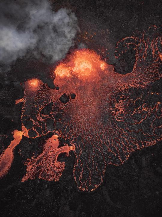
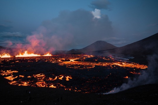
Red Beast - Meradalir Volcano, Fagradalsfjall, Iceland [1381x1853] [OC]
5 notes
·
View notes
Last Seen Blogs