
Last Seen Blogs
peachssodapop
Queering Characters Into Oblivion Since 2016
justafangirlwithideas
Just a Fangirl With Ideas

she-wore-a-crown-and
she came down IN A BUBBLE DOUG! Grow up, bro

hellogatorbymoni
Untitled

weeb-nectarina
Weeb In Denial
Text
The Amazing Red Centre, Northern Territory, Australia
It has been some time since I have posted any thing here, what with work commitments, having to get things done around the house, and just a very busy life, not mention the desire to escape at every opportunity to kick back and unwind, time to sit down and write about our adventures has been in very short on.
After spending a far bit of time completing some projects around the house we decided we need to get away but were unsure as to where to go next. One Saturday morning while eating breakfast and trawling through the regular newspaper and social media websites, a article caught my eye, it was about "The Field of Lights" at Uluru, it fascinated me, and the more I read, I thought why not , maybe we should go to Uluru and checkout the "The Field Of Lights" display.
The first thought was to drive our camper van, to central Australia from Melbourne, approx 2500 km, the time frame available was at most 10 days that meant there would be a lot of travelling in a short period of time, and at least 2500 km over the same route, this was not something wanted to do as the idea was to get away and unwind. The decision was made to fly to Alice Springs in the Northern Territory and hire a camper van and explore the surrounding area, including Uluru, Kings Canyon and The West McDonnell Ranges.
The decision to fly was a good one, 3 hours from Melbourne we were in Alice Springs, the dead centre of Australia. One hour after landing we were driving away in our home for the next 10 days, a Toyota Hi Ace Camper (not as nice as our own van, but it would be comfortable), as it was early afternoon the first stop was the supermarket and bottle shop to provision the van for the next 10 days and then find a camp ground to stay for the night, and start to kick back and unwind, as tomorrow we had planned to drive to Uluru 460 km (5 1/2 hours).
After a good nights sleep it was up early and hit the road, as we drove south out of Alice springs through "The Gap", we passed a huge solar power farm, Alice Spring's power is generated using the sun, 2300 megawatt hours (MWh) of electricity per year.
The road south did not disappoint, it was straight and the landscape was flat, with a mixture of red sand with salt bush, and gibber dessert, there was the occasional undulation, sand dune, and every so often we came across some rocky outcrops, it sounds boring but it was quite beautiful, the shear vastness of this country was amazing, and there were subtle changes in the vegetation all adding to the beauty of the outback, not to mention the wildlife, large goannas on the road, emus, and many predator birds like eagles.
We had arrived in Central Australia a couple of days after a period of wet weather, so the vegetation was quite green and there is an area you drive through that is dotted with salt pans, but these were all full of water that attracted a lot of bird life. We came across a lake that I was keen to photograph, so I decided to pull off the bitumen road and head down a track to the lake, it was quite vast and worth the detour, until we went to turn around and head out, the the tyres on the van did not have much tread, and below the surface of the dry ground it was very soft, and guess what we, sorry I bogged the van, after a bit of digging by hand, some nervous sweating, and prayers the van came free, much to the relief of Dianne. Ok no more of road work in a two wheel drive Hi Ace i promise.
Only a few Kilometres up the road you travel past Mt Connor, it fools many people as it looks similar to Uluru, we pulled over to admire the view and on the other side of the road there is a look out that looks out over a series of lakes and across to Mt Connor we climb the sand dune and admire the landscape before us, it is so different from the mountains, country side of Victoria and the Rainforests and mountains of the Queensland.
The sand and ground is so red and the sky is so blue, the vegetation is a combination of salt bush, small bushes, and grasses in many different hues between of white to deep greens.
After stretching our legs, and a small snack, it was back on the road after about one hour we arrived at Yulara (this is the area set aside for accomodation, camping and a small retail area. About 15 km away from Uluru) and booked in to the campground, had some lunch.
After lunch we headed out to Uluru (Ayres Rock) to explore. As you approach you realise just how much it dominates the landscape and the closer you get you realise how massive this rock is. We spent the afternoon walking on the shaded side of the rock and explored a couple of the water holes, and caves with Aboriginal paintings and just took in the beauty of this place. As it was getting late we had to head the sunset viewing areas, and get a good vantage spot for the natural sunset light show. What a great way to end our first day in the outback sitting back enjoying a cool drink and watching the Rock change the most amazing colours as the outback setting sun reflected upon it.
vimeo
Day 2 at Uluru, up bright and early, well not so bright it was 5.00am and pitch black but we were up early to view sunrise over the rock, so we headed to the viewing point and secured our spot for the morning and sat back and enjoyed the morning coffee rising on the rock.
vimeo
Once the sun had risen we found a nice BBQ area and enjoyed bacon and eggs for breakfast in the shadow or Uluru. After breakfast it was time for a walk a 10.6 km walk around the base of Uluru, exploring caves, rock paintings, water holes and just taking in the sheer size and beauty of this massive rock.
The afternoon was spent relaxing around the camping area, and getting ready for our evening out, we were picked up at the camp ground and taken to a "secret sand dune'" where we were treated to sunset drinks and canapés as we watched the sunset over Uluru and the surrounding desert, the colours of the sunsets in the outback are spectacular.
As it was getting darker, the desert before us started to glow very faint at first but the darker it got the brighter the lights became, this was the field of lights display. The artist Bruce Munro has laid out 50000, slender stems crowned with radiant frosted-glass spheres over an area the size of seven football fields, with kilometres of cabling in the middle of the desert with the back drop of Uluru.
We wondered around the Field Of Lights for about an hour before being taken back to our campground and turning in for an early night, it had been a huge day.
Up bright and early with the sunrise again, to beat the heat as today we are of to Kata Juta (The Olgas) and plan to do the Valley of the Winds walk. Kata Tjuta is 53 km from Uluru the plan was to get there early enough and complete the walk before the hottest part of the day, the forecast was for 35 degrees. Kata Tjuta is very visible on the drive there, as you approach the size becomes very apparent, they are massive, The Olgas consist of 36 rock domes and are approximately 200m higher than Uluru, and it is approximately 22 km around the perimeter of the formations.
The Valley of the wind walk takes about 3-4 hours depending on fitness levels. The track rises from the carpark adjacent to the massive rock domes, and then descends into a valley between the domes there is a running creek lined by white trunked gum trees, there foliage appears florescent green against the oranges and the reds of the rock domes, and the sky is such a deep blue (as a bloke I was speaking to on the walk said if Australia is to have a new flag it's colours should be the Blues of the sky, the red/orange of the outback soil and rock and the green of the gum trees). The walk meanders along the creek for a while around another massive rock dome, and the ascends up a gap between two domes, it is nice and cool here in the shade, you keep climbing until you reach the head of the valley and the narrowest point between the domes. At this point you are welcomed by a vista that is hard to describe the valley opens out into another massive valley surrounded by the rock domes.
At this point it was starting to get very hot so we started our return to the carpark. Kata Tjuta is so majestic it must be seen, it is hard to describe in words, personally we felt that Kata Tjuta (the Olgas) were more impressive than Uluru.
After a relaxing afternoon, we treated ourselves to a helicopter flight over Uluru and Kata Tjuta at sunset, what can I say simply spectacular, the way the sunset lit up the landscape and the massive rock domes. From the air it puts the shear size of these massive rock features in to perspective as they tower above the surrounding desert.
It was up early again watch one last sunrise over Uluru, breakfast and hit the road. Today we are bound for Kings Canyon, a 306 km drive which should take about 3 1/2 hours. As I said earlier it had been raining prior to us arriving and so there were several lakes that would normally be just dry salt pans along the way, we pulled over take a closer look at one, it is amazing how much bird life these lakes attract. This was the first real chance I had to get the drone out and get some footage of the out back (you are not allowed to fly them at Uluru).
vimeo
Again the landscape changed from flat desert to undulating sand dune country and as we got closer to Kings Canyon, rock outcrops, and then rock ridge lines to mountain ranges all in the colours of the out back the Oranges, reds & yellows.
After checking in to the campground it was time to explore the area, drove back about 10 km to a side road we had noticed that had a sign to a small gorge, where we could go for a walk and stretch our legs.
This gorge was used in years gone by as a natural coral for cattle during muster periods, the cattlemen had fenced of the opening to the gorge and that kept the beasts in and from wandering off, it had a natural water hole that provided water for the beasts and also provided water to the vegetation in the gorge, so it was the perfect spot for a muster camp.
After the walk it was time to head back to the camp and to the Pub to enjoy a cold beer and watch the sun set over the mountains.
While cooking dinner on the BBQ there was a Dingo hovering around, I tried to shoo it away but it just lurked in the shadows, I turned my back on it for a couple of minutes and that was all it took it snuck in and grabbed the butter container from the bench, and given another opportunity it would of taken the meat from the BBQ, lesson learned when cooking a BBQ keep and eye on it at all times in the part of the world.
The weather forecast was for another hot day so again up with the sun and get moving early, to day we were doing the Kings Canyon rim walk, it is a 5.5km walk that takes you up one side of the canyon and around the rim and back to the carpark.
The first stage is quite a steep climb and pretty hard going, but once at the top it is a reasonably comfortable walk all be be it over rocky and uneven paths.
The rock formations here are amazing some look like brick walls, other look like battle ships, and then there is the sheer cliffs, all in vivid oranges, reds and yellows, all contrasted against the vivid blue sky, not to mention vegetation The ghost gums, cycads and amazing climbing species i did not recognise. At The head of the canyon there is another smaller canyon called The Garden of Eden, there is a permanent water hole and it was so cool in the shade of the rock walls, the vegetation was very dense and so many different species, so beautiful.
Every step of the walk revealed a different vista, another hidden gorge, creek bed or the spectacular sheer rock walls.
Its going to be a big day we have a 600+ km drive back in to Alice Springs and the out to the West MacDonnell Ranges, so again another early start to but it started before sunrise, but it was a beautiful drive as the sun slowly crept over the horizon at the different hues of the sky soft pinks, mauves and pale blues changing to burning oranges yellows and vibrant blues, with a back drop of the outback, the country was waking up, there where even wild horses on the road along with kangaroos and emus.
A quick stop in Alice Springs at the supermarket to restock the cupboards and fridge and then off to the west following the ridge lines of the MacDonnell Ranges until we reached our destination of Ormistan Gorge, set up camp in the small camp ground and time for a short walk, Wow this place is awesome, the most beautiful waterhole we had been to this trip, lined by red cliffs and a and beach lined with River Red Gums, the perfect spot to chill out and enjoy a cool drink and swim to cool off (be it a short dip as the water was bloody freezing) but so beautiful. it going to be nearly night after a long day on the road.
The weather has cooled down a little so it was nice to lay in bed under the covers this morning and have a slow start to the day, chat with other campers about the area and their travels over a cuppa. The plan to day was a walk along the top of the gorge and then down into the gorge and walk back along the creek like every where here in The Red Centre, the rock is a vibrant orange, which was the perfect contrast to the sandy beaches and water holes, that reflected the the greens of the trees and the blues of the sky.
Ormistan Gorge was great spot to camp and a base to visit the other places of interest in the West MacDonnell Ranges, from here went to Glen Helen Station, Ellery Creek Big Hole, Serpantine Gorge and The Ochre Pits. All the water holes were full of water and again this attracted all sorts of birdlife.
The Ochre pits were fascinating this where the local people come to gather the different coloured ochres for their body and face paints for special tribal ceremonies. The walls are a myriad of different colours.
All along The West MacDonnell Ranges there is gaps through the mountain range and it is at these gaps and gorges the water holes form, all beautiful in their own right and worth a visit and explore.
At night the sky are so clear and with no light pollution the sky are fill with millions of stars, i could sit out and just watch the stars for hours.
Well it is last day in the camper van so we headed back to Alice Springs, but not before stoping at some of the other places Stanley Chasm and Simpsons Gap. Stanley Chasm is the only place we had to pay to visit other than Uluru, and was a little disappointing after all that we had seen, it is a narrow gorge with sheer rock walls that lights up at when the sun directly over head, there was many people here all waiting for the moment it would light up.
Now to drop the van off and chill out at our hotel for the night, well so much for an afternoon of watching the football and calling out.
There was a Harley Davidson Hog Convention in town, well in our hotel, some 500 Harley owners and their bikes out side our window going around and around and just having a good time all be it noisey good time. Then at night there was their dinner complete with band, it was going to be a noisey night, but fortunately the average age of the Harley owners and friends was about ten years older than us so they were all tucked up in bed at respectable hour and all quite.
This awesome trip has come to an end and time to fly back to Melbourne and work.
If you have ever thought about a trip to The Red Centre, just do it do. It is a beautiful part of our country and is as good if not better than the all the hype.
Till our next trip!
3 notes
·
View notes
Text
Black Betty our Adventure Vehicle
For sometime we had talked about getting a van and putting a mattress in it, nothing to flash just something very simple, so we could just escape the hustle and bustle of our busy lives.
We looked around at car yards and started to follow websites that featured campervans, trying to find the ideal van for our needs, after looking for some months we decided on a Volkswagen Transporter, but to find one with low kilometres and was not priced beyond our budget was posing to be difficult, then one evening during the regular scan of the cars for sale websites, I found a van that looked like it would be ideal and not priced over the top. The next day we drove across town to check it and it was ideal so we bought it.
It was a 2010 Volkswagen Transporter Long wheelbase hightop van, it has a turbo diesel engine with automatic transmission and reasonably low kilometres, and Jet black (this is unusual for this type of van as most are white). The van had been used as a florists delivery and pick up van, it was a little bit grubby inside, but a little bit of elbow grease fixed that.
Now the plan was to keep it simple just a mattress and some basic camping gear! After researching camper van websites and seeing all the great ideas, from storage solutions, kitchen layouts, and power systems to power all our devices that are part of our lives now, our plans changed. Having a blank canvas (or empty shell of van) our mind were racing with ideas of all the things would need and all the things we would like in a van.
So the project of converting this once a florist delivery van in to a weekend adventure vehicle began.
After looking at other vans we planned on have in a side kitchen with a "U" shaped lounge with a drop down table that would form a bed for sleeping at night, and because the van was a hightop this allowed us to have overhead storage cupboards. The other thing we thought would be good was a windout awning of the side of the van, this would provide additional living space and protection from the sun and rain.
In the kitchen area we would need a refrigerator sink, cooktop, microwave oven and additional storage cupboards.
We had decided we would need a fairly large battery to run all the electrics in the van and to charge it we would need solar panels on the roof as well as being able to plug in to power in caravan parks, in addition to this it charges from the engine when we are driving.
The first thing we did was strip the plywood linings from the cargo bay, cleaning it all up. then installing the solar panels on the roof, cutting in a ventilation hatch in the roof and installing the awning on the side of the van.
As the van did not have any windows in the cargo bay we had three installed one above the kitchen bench and two along the kerb side of the van.
I had read on many camper van websites that insulation was very important as it reduces how hot the van would get in summer and how cold it would be in winter, but more importantly it would reduce the amount of condensation that would form on the metal body of the van and also deaden the road noise inside the van whilst driving. So we double insulated the walls, floor and roof of the van.
At this stage it was important to rough in all the wiring for the lighting, appliances, power points, solar power supply, and charging systems. This was completed over the course of a weekend, we were the ready to install the wall and roof linings.
The walls and roof were lined in MDF sheet and then covered with a special carpet designed for lining the inside of boats, what a job that was it took 4 day to cut and glue all the carpet in to place, very fiddly. The floor was lined with self adhesive vinyl flooring that looks like timber floor boards.
With a plan for the Lounge/bed set up, we went and purchased the foam for the cushions and had it cut to size. This now governed the size of the lounge base units that would also double as storage space. The next thing was to select a suitable fabric for the seats, cushions and curtains, and recruit the services of my mother in law to sew the covers for the cushions and the curtains for the windows, she did a great job and at the right price.
Whilst the cushions were being covered I got to work on fabricating the all the cupboards, seats and bulkheads, this was done using a laminated MDF sheet, another fiddly job this must of taken two weekends.
All the time I had been working on the van I had been shopping around for Deep Cycle battery, refrigerator, cooktop, tapware, microwave oven, hot water unit, Water tank, water pump, Dc to Dc charger, AC to DC charger, 12v to 240v inverter, light fittings and fan, Most of these items I found on eBay at very reasonable prices, most other materials were purchased from Bunnings and Jaycar.
Now the walls and roof were lined and the cupboards we installed it was time to install all the electrical fittings and lighting, and to my surprise it all worked as planned, all the research had paid off.
The next major task was to install the freshwater tank, pump, sink, shower and hot water unit. Installing the freshwater tank under the van was fairly straight forward except the space was quite limited, once it was installed it was just a matter of running the plumbing hoses to the pump, hot water unit, sink and shower, and again it all worked as planned.
The final touches of installing the curtains, cushions, and table was the next thing to do. At this stage the van conversion was complete, just some minor fine tuning some storage nets in the cupboard, a couple of towel rails, etc to make it work a little better for us.
The whole idea about buying the van and converting it to a camper was to provide us with the means to escape on weekends, to explore and photograph places we had never been to, to escape the hustle and bustle and stress of our day to day lives, to get out into the bush, mountains, and by the ocean and get closer to nature, and just relax and unwind.
We plan to get away a lot more this coming year, and our adventures will be shared here in blog, photographic, and video format for you enjoy, and maybe you may choose to join us on our adventures.
0 notes
Text
Weekend escape to Kilcunda.
A mild fine weekend was forecast, and being late autumn it could be the last nice weekend we are likely to have for sometime, it was mid afternoon Friday, van was packed and of we went, heading to the Bass coast in Victoria, a relatively short drive of 1 1/2 hours. We arrived before dark and were lucky enough to get a cliff top site over looking Kilcunda Beach.
The camping ground is located across the road from the Kilcunda Pub, your typical country pub that serves great meals, so dinner was sorted at the pub. On our way over there some one was calling us from behind, turned out to be some friends of ours who we had not seen for about 6 months, they have a caravan onsite there and get to Kilcunda every other weekend, it was great to catch up over dinner and a glass or three of red. It is great to catch up with friends out of the blue like this.
Saturday morning a beautiful still warm morning, the ocean was calm and a beautiful pre dawn glow, it was going to be nice day. After breakfast we mounted the bikes and headed of long the Bass Coast rail trail to Wonthaggi. The rail trail heads east out of Kilcunda and the first thing you come to is the Historic Trestle Bridge the bridge is an iconic feature of the area, crossing a small creek and adjacent to the surf beach.
We continue on riding adjacent to the coast and enjoying the views of this beautiful section of the coast, the trail leaves the coast and pass through grazing and dairy farms, beautiful green and lush farmland.
About 5 km in to the ride we came across a paddock that was full of Kangaroos there must have been 100 of them, just grazing on the lush grasses.
Along the trail you pass over and by rivers and wetland with an abundance of wetland bird life. As we neared Wonthaggi you pass by the wind farm, where electricity is generated, Yes the wind farms are huge windmills and are a form of visual pollution but nothing like the scars on the countryside like the open cut coal mines of the Latrobe Valley and there is not any coal fired power stations belching out smoke and steam, Certainly a lot cleaner way to generate power, and the wind just blows in from the ocean most days of the year.
On the outskirts of Wonthaggi we came across as pine forest with red toadstools and pine mushrooms hoping up everywhere, time for some foraging, we collected enough pine mushrooms for breakfast the next day.
Wonthaggi was established in 1910 when the State coal mine was established to ensure continuous supply of coal to the Victorian Railways, today Wonthaggi is home to the controversial Desalination plant that was constructed in recent years to guarantee water supply to the people of Victoria but it has never been put into commission to date. Wonthaggi is a smallish regional town serving the local region of the Bass Coast.
After a coffee and a chocolate eclair it was a leisurely ride back to our camp at Kilcunda.
The rest of the afternoon was spent exploring the beach and coves directly below the camp ground, and as the sun was starting to descend in to the ocean the sky began to change colour and as the last light of the day faded the sky lit up into the most spectacular light show of reds, pinks and oranges, and to top it off it was all been reflected in to the mirror surfaces of the rock pools on the rock shelf at low tide, an amazing light show.
Our daughter, her husband and two dogs decided to join us for the evening, they arrived rolled out their swag and we settled in to an enjoyable evening over a beautiful dinner and catching up with family under the stars on top of a cliff by the ocean.
Sunday morning the mushrooms we collected the day before were prepared with eggs,bacon, spinach and sprouts and cooked up into a huge omelette for breakfast, we all packed up camp and headed off.
We stopped on the way back and walked a section of the George Bass walk along the cliff tops one of the most rugged and spectacular sections of the Victorian Coast line, we only walked for a couple of kilometres as the legs were still fatigued from the previous day. We will certainly be back to this part of the coast to complete the George Bass Coastal walk as what we saw was awesome, and the bass coast is only a short drive from home.
0 notes
Photo

The Horn
Stunning Bright and Mount Buffalo in North Eastern Victoria. #travelandlleisure #landscapephotography #photography #sony #a7r #sonya7r #holidays #roadtrips #campervan #wandervictoria #visitvictoria #victoria #australia #bright #mtbuffalo #Mountbuffalo #discovervictoria
0 notes
Photo

Moke Lake, Queenstown, New Zealand
Beautiful Moke Lake on New Zealand's South Island, #landscapephotography #photography @sony #a7r #sonya7r #pureNZ #NewZealand #queenstown #NZMustdo #paradiseNZ #RealMiddleEarth #queenstownlive #reflections @queenstownholidays @queenstownnz @purenewzealand
0 notes
Photo
Mount Buffalo
Stunning Bright and Mount Buffalo in North Eastern Victoria. #travelandlleisure #landscapephotography #photography #sony #a7r #sonya7r #holidays #roadtrips #campervan #wandervictoria #visitvictoria #victoria #australia #bright #mtbuffalo #Mountbuffalo #discovervictoria
0 notes
Text
Bright, Victoria.
The end of April is primetime for autumn colour in the King and Ovens Valleys in North Eastern Victoria. The van was packed up and we were off, heading north from Melbourne via the Melba Highway, passing through the wine producing region of the Yarra Valley and the township of Yarra Glen, then on to the grazing areas of the Goulburn Valley and the township of Yea. A coffee stop was called at Yarck, before then passing through the lakeside town of Bonnie Doon, passing over the dry Lake Eildon (well in the Bonnie Doon area at least) and on to Mansfield the gateway to the Victorian high country and the Ski resorts of Mount Buller and Mount Stirling, this is "Man from snowy river" country where Graziers would allow their cattle to graze during the summer months, as the weather cools the graziers would mount their horses and head in to the mountains and round up their cattle and bring them down to the low lands for the winter months. But this is not our destination for the weekend so we continued on along the Mansfield - Whitfield Road winding up in to the mountains and the town of Tolmie and then down into the King Valley and our lunch destination of the Whitfield Pub. The Whitfield pub had been highly recommended for lunch by friend's of ours, so it was a no brainer for our lunch stop. During the post war years many Italian migrants settled here as the climate was similar to parts of Italy, and with them they bought with them their wine producing skills and grapes, not to mention other agriculture and culinary skills. Today the King Valley is renowned as a premier wine producing region and a foodies paradise. The Whitfield pub is no exception owned and run by an Italian family and offering great Italian and European food and beers, and great locally grown and produced wines.
On a full stomach it was back into the van and down the road enjoying the vistas of vineyards in full autumn colour and the contrast of dry grazing properties enroute to Edi (mental note to self must comeback here and check out the camping here),Oxley, Mliawa and Myrtleford.
The Myrtleford region used to be the home of tobacco farming in Victoria, but now days farming of wine grapes, hops, berries, walnuts, olives and beef has taken over.
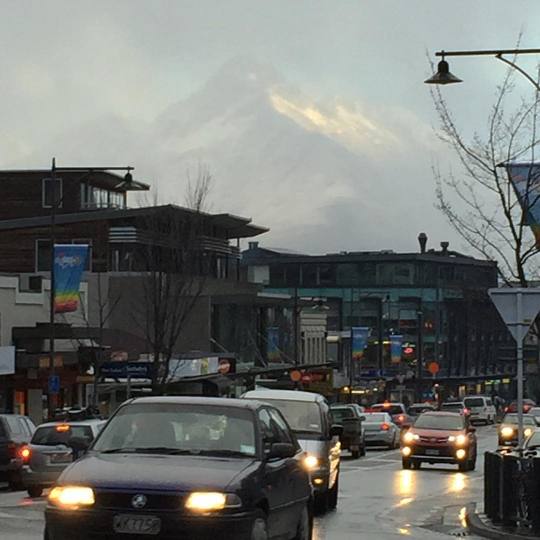
From Myrtleford we continued along the Great Alpine Road following the Ovens Valley towards the Australian Alps, we are getting close to our destination, with Mount Buffalo towering on our right we pass through Porepunkah and a short drive on we arrive at the sub Alpine town of Bright.
This is not our first trip here for many years we have travelled through Bright without more than a fuel stop and a quick meal enroute to the Ski Resorts of Mount Hotham and Falls Creek during the winter months to enjoy weekends skiing in the mountains, then two years ago we came here during autumn and spent a weekend here and loved it.
We found our accommodation for the weekend unpacked, grabbed a bottle of wine headed up Mount Buffalo to watch the sunset over the mountains, however the cloud had rolled in so the sunset was a fizzer, so we found a vantage point just below the historic chalet over looking the sheer rock cliffs and walls and down in to the Ovens Valley below and enjoyed a glass of wine with our good friends whilst the day faded in to night.
Once it was dark we drove back to where we were staying. On the way we had a near miss with a rather large stag, he was not concerned about us he just wandered down the road and of into the inky black bush.
It had been a big day, so it was time for a great home cooked meal, more wine, great conversation and and early night.
The weather forecast for to day was not great, a cool change with high winds and rain, so we decided to stay close to Bright, after breakfast we ventured out before the change arrived and walked the "Cherry Walk" , a loop walk that follows the Ovens river up stream about 4 km, crosses the river then returns back to Bright through natural bush and a small area of pine plantation, a very leisurely walk lots with of chatting.
It just happened to be my birthday so as we passed the Bright Brewery my mate suggested he would buy me a beer to celebrate, as it was almost lunchtime, and one never to knock back a free beer we found a table out on the deck over looking the river. Just as we were getting settled the wind came up very quickly and very strong, autumn leaves were flying everywhere and then came the rain, we moved inside and enjoyed a very nice lunch and a couple of more beers, whilst waiting for the rain to stop.
vimeo
As the rain did not ease we ventured out in to the elements and by the time we got back we were all wet. Drinks in the middle of the day make me sleepy, so an afternoon nap was the order of the day.
As it was my birthday my beautiful wife had book us in to a place call "Tani" a Japanese inspired restaurant, the menu was quite different to traditional Japanese food, using freshly caught and locally farmed produce, great service, great ambiance and great food and wine, I would highly recommend "Tani" to anyone who is headed to Bright.
Saturday morning, the rain has stopped and the plan is to head back up Mount Buffalo to check out some of the waterfalls and do some bush walking, first stop was Lady Bath Falls and Eurobin Falls. On the approach to the starting point we get our first glimpse of the Eurobin Falls, water cascading down the massive granite walls. The walk is about 3 km return following a well maintained path, a little steep in places but not for long, the vegetation is a combination of rainforest complete with ferns, lichens, and fungi and the towering mountain ash of the victorian alpine regions. Bushwalking in the bush after rain is so nice the bush is very special the air is cool and moist, the colours of the vegetation are so vibrant, and the smell is something special. The creeks and water falls were alive with cascading and moving water.
Lady Bath Falls are the first falls you come across, beautiful water fall surrounded by ferns cascading over granite boulders in to beautiful pool of crystal clear mountain water then running of into a pretty creek again lined with ferns, Further along the track you come across a massive granite face with water cascading over it, this Eurobin falls very spectacular, we have been so lucky to be here just after some heavy rain fall.
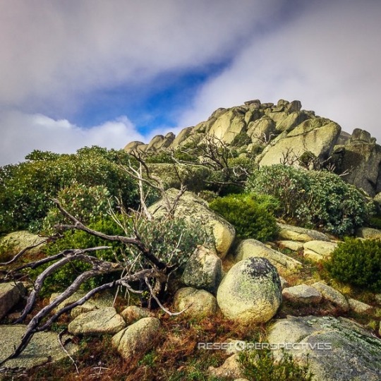
Once up on the Buffalo Plateau, the landscape changes to large boulder outcrops, heathland and the Mountain ash gives way to Snow gums as we are now above the winter snow line about 1600m, there are lakes up here also the largest is Lake Catani with a camping ground adjacent, very pretty, the whole of the area is a bushwalkers paradise tracks and paths every where, and the Rocky outcrops have names like "The Horn", "The Cathedral" and the Gorge all amazing. We are already planning a trip back here in the warmer months for some bushwalking and try and capture the beauty of the area with my camera.
We walked to the highest point on mountain at "The Horn" 1730m, the track weaves between over an around massive Granite boulders, passing through glades of snow gums. The Summit was shrouded by a blanket of cloud so we could not appreciate the full view, but as the wind was quite strong up here the clouds were moving all the time, stirring and churning around the mountain, clearing briefly then closing in to reduce visibility to mere meters, then clear again all within minutes. The beauty of this mountain has to be seen.
Bright was chosen for the weekend as it was prime time to view the autumn colours of the trees before they loose their leaves for winter, the avenues of trees are spectacular, red, orange and yellows, and leaves covering entire gardens, so beautiful and so different to the Australian bush. The town of Bright was very busy as it was the Autumn festival, with parades, displays and all sorts of festivities. The Brewery seemed to be the centre of activity and surprise, surprise we ended up here again, it is just a great place to enjoy a beer or cider, people watch and just kick back with friends.
Sunday morning the weather was turning again so we went for a short drive to Wandiligong to see more autumn colours, the are large stands of colourful deciduous trees, farm driveways lined with flaming yellow Poplars and apple and pear orchards and throw in some beautiful old buildings and you have some beautiful views. As the weather was closing in, it was time to head home, the end of a great weekend spent with great friends.
I have posted some of my of photographs I have captured in this trip to the Victoria gallery, just follow the Bright Gallery
Please share this web page with your family and friends, and enjoy my images.
Please feel free to leave comments below they are much appreciated.
0 notes
Text
Walhalla and Mushroom Rocks, Victoria.
Life has been very busy over the past few months since the summer holiday period, what with getting back in to the daily grind of work, trying to spend as much time as we can at the beach, whilst it is was still warm, and fitting out a campervan so we can escape for weekends to explore areas of the country, mountains and coast we have never been to or seen before. With the van almost complete, all bar a few small items, the time had come to head of on our maiden trip to try it out. After chatting with our daughter who mentioned it may be a good time to visit some of the small towns in the hills, as all the deciduous trees would be in full autumn colour we decided we would go to the old mining town of Walhalla, located deep in the mountains west of Mount Baw Baw in Western Gippsland.
Rather than take the shortest route, we opted for the scenic route through the rolling hills and lush green farm land of South Gippsland, passing through Korumburra, Leongatha, Mirboo North and Morwell.
Not far out of Morwell we came across the Yallourn open cut coal mine, what can I say, The countryside had been gouged deep for as far as you can see, in fact from our vantage point you could not see the bottom of the pit, a massive scare on the country side that can never be healed, all for the generation of electricity, there must be a better way, a cleaner way, a way that does not rip the earth open. This was a real shock to us as we had never been this close to an open cut coal mine.
Continuing north it was not long before we started our ascent into the foot hills of the Great Dividing Range, the country changed from lush farm land to eucalyptus forest, then to towering Mountain ash forests, some scared by bushfire giving great contrast between blackened trunks and vibrant green leaves of the new growth. After winding up through the mountains we descended down to the Thomson river, as you wind down in to valley there are flashes of vivid yellow of the poplar trees, in amazing contrast to blue-greens of the Australian bush, these deciduous trees look so out of place.
The first sign you are entering Walhalla is the tram station on the banks of the Thomson River from here the road winds it's way into town. Walhalla is a small village spread along the banks a small creek at the floor of a valley with very steep hills/mountains on either side, it would only be 4 kilometres from one end to the other.
During the gold rush of the mid 1800's Cohens reef was discovered and soon after the Long Tunnel Mining Company was established this mine is located above the centre of the town, between the 1860's and 1900 the Reef had produced over 55 tonnes of gold, during the period of time the population of Walhalla was in excess of 4000 people. The town had many hotels, shops and traders, there was a hospital, churches and even a cricket ground on a flat area high above the town, there was even a tram line to transport gold and supplies along the valley. The main mining companies ceased operation in 1914 and with the disappearance of the main industry so did the people.
Today the Long Tunnel mine is open for tourists to visit, a hand full of the original buildings have survived including the rotunda, fire station, hospital, and post office. There is a pub a few shops and several quaint old world cottages.
We set up camp at place called North Gardens, a free camping area just out of town on the creek, an area with BBQs, picnic tables, toilets, fire pits, nice grassy areas, and great trees covered in autumn colour, a very pretty spot. As it was Friday, Walhalla was all but deserted, only a few small groups of sightseers, but as the afternoon wore on the camp site started to fill up. We decided to eat at the pub this night so we walked into town just before dark, on entering the pub the whole current population of the town was there, all 30 of them! The food was standard pub fair with a twist, the beer was cold, and we headed back to camp up the road and it was dark very dark, our biggest concern was tripping over wombats in the dark.
On waking in the morning we were amazed at how many groups had moved in to the camp over night, it is a very popular destination for weekend campers.
Walhalla is the southern starting point of the Australian Alps Walk, if you are feeling fit you can walk through the Australian Alps to Canberra approx 650 km, we decided to walk a short section of the walk. The walking path is elevated about 100m above the creek and valley floor, and follows the path of the abandoned tramline, there are some great vantage points of Walhalla along the way. At this time of year the valley is mixture of yellow, orange, red, and every colour in between all set against a backdrop of blue-green of the Australian bush, not mention the stands of tree ferns scattered in between, the occasional shaft of wood smoke coming from the odd chimney and the morning sun streaming into the valley and you can imagine the postcard views, very pretty. We followed the walking track for about 5 km before returning.
After packing up we headed out of town and headed the town of Rawson and then on to the Thomson Dam, Thomson dam was built during the late 70'sand early 80's to drought proof Melboune's water supply, it is the third largest dam connected to a capital city in Australia and has a capacity twice the volume of Sydney harbour, it is perfectly located amongst the mountains and adjacent to the Baw Baw National Park. Great spot for lunch over looking the lake and the mountains.
On the way back I spotted a sign to a place called Mushroom Rocks, on Mount Erica. I had read about this place and it had been highly recommended as a great walk so we detoured and followed the road up to the start of the walking track. The walks starts of in a temperate rainforest complete with ferns, lichens, and funguses all protected with in a forest of towering mountain ash, the walk follows a well maintained path and series of boardwalks provided by Parks Victoria, takes you past small creeks with waterfalls of crystal clear water, at times the ferns provide a complete canopy overhead, that offers a great habitat for native animals, not that we saw any except for a Lyrebird that flew across in front us, about 1m away and caused a brief period of panic for some. This was a first as we had never seen a Lyrebird in the wild.
The walk was beautiful, all the way there are large moss covered granite boulders strewn across the mountainside, the higher we climbed the rainforest gave way to more open vegetation, the mountain ash are amazing during autumn as they have shed their bark to expose smooth vibrant coloured trunks of cream to orange and green. We followed the path for about 3 km where the boulders became closer together and larger, we assumed this was the Mushroom Rocks (we later found out we should walked a little further), this is a very special place so peaceful and beautiful, we will be back, but for now we will have to wait till after the snow season has finished.
Because we were in the Western Gippsland area it was good opportunity for us to catch up with our daughter, so her place was our next stop.
During the night it had rained, so in the morning everything had a fresh feel after the rain, perfect mushroom growing conditions, so before breakfast we were all loaded into the car including the dogs and of to a pine forest to forage for pine mushrooms, I was a little uncertain about this as my up bringing was you only ate field mushrooms, but I was reassured that pine mushrooms are fine to eat. So of we went in to the forest and collected enough mushrooms for breakfast. It was amazing how many verities of mushrooms and and funguses were growing in there.
After a beautiful breakfast of fresh mushrooms, freshly picked vine tomatoes, poached eggs and spinach, it was time to head home.
The maiden trip in the van was successful without any major issues, so we are now looking forward to our next weekend away.
I have posted some of my of photographs I have captured in this trip to the Victoria gallery, just follow the Victoria Gallery link
Please share this web page with your family and friends, and enjoy my images.
Please feel free to leave comments below they are much appreciated.
0 notes
Text
North Stradbroke Island
Australia's best kept secret!
Our introduction to North Stradbroke Island (Straddie as it is affectionately referred to by the locals) was by virtue of very good friends of ours taking up the management of a bistro located on Straddie. Having visited Brisbane on several occasion in recent times we thought it would be great to catch up with old friends, so the car was loaded up and we headed off down to Cleveland to catch the car ferry across to Straddie. The trip across Moreton Bay on the ferry takes about 45min and you arrive at Dunwich on the western side of the island, once we had disembarked we head north to the sleepy little village of Amity Point, where our friends where living. Life in this part of the world is at different pace to the hustle and bustle of Brisbane and on the mainland you immediately feel like you are on holidays. Amity Point has a General store, Camping ground, a couple of fishmongers, small/bar cafe, community club and a boat ramp, most people come her for the fishing and boating.
We had booked into camping ground about 12 km further around the coast at Adder Rock. The site we had chosen was 30m from the beach in a protected area of the camping ground, it was well treed and offered shade during the day and the trees acted as a wind break also, a great spot for the next week. After setting up camp thanks to our generous friends providing the use of their camper and helping set up camp it was time for a cold drink or two, a catch up and a swim in the crystal clear water at the beach.
North Stradbroke Island is a mecca for those wanting to get away from crowded beaches, all you need is a four wheel drive vehicle and you can head off down Main beach on the western side of the island or head to Flinders Beach on the northern end of the island to find your on secluded section of beach. There is bush camping at selected sections along these beaches (a permit is required) just find a free area and set up camp.
Time to explore, with in a short drive of Adder Rock Campground there is are pristine beaches aplenty there is Flinders beach to the west, the picturesque Cylinder beach to the east and further on there are the beaches surrounding Point Lookout. Point Lookout is a rocky headland that conceals rocky bluffs, cliffs, blowholes, and gorge beaches. The headland walk is a must it starts opposite the Gelato shop and heads towards the east and follows the cliff line around to Main beach past the lifesaving club, the path very well maintained and where required boardwalks have been constructed so the walk is easy going, the views are spectacular of crystal clear turquoise water contrasted against the blue skies, rocky outcrops and Pandanus Palms. If you are lucky at Gorge beach you will be able to witness sea turtles frolicking in the shallows, or schools of dolphins surfing the waves just of the cliff faces, or huge Manta ray cruising by.
North Stradbroke Island is not all about the beaches though, there is more! There are beautiful freshwater lakes, a short drive down main beach and just inland from the beach you can find The Keyholes, we spent a great afternoon here eating fresh local prawns and oysters all washed down with icy cold beer then followed by a cooling swim in the lake, just a tip get there early to get a prime spot in the shade of the surrounding trees.
If you do not have a four wheel drive there is Brown Lake not far from Dunwich, or if you are feeling a little energetic keep going past Brown Lake and to the Blue Lake Walk carpark and take the walk in to Blue Lake it takes you through changing areas from bushfire scared bushland swampland and beautiful grass tree forests until you reach beautiful Blue Lake tucked away in the middle of the bush.
As it was late January it was quite hot, so for the most part our holiday was spent on the beautiful beaches, whilst we were there a cyclone went through the The Tongan Islands which in turn provided large surf along the south east Queensland coast with most exposed beach being closed due to dangerous surf, but at Adder Rock we were a little protected from the huge swells just enough to give us 4 days of great surf and every one who surfed was on our beach.
Unfortunately i had a fall off my board and it cracked me in the head, an embarrassing walk along the beach with blood pouring from my head, an ambulance ride to the medical centre and 7 stitches and that was the end to my surfing for the week, all i could do was paddle in the shallows.
Later that week we went to a beach just to the north of the lifesaving club at Point Lookout, this beach is so beautiful, huge cliff along one side and a natural rock spit on the other side, and again that crystal clear turquoise water and gentle surf rolling in it is the perfect spot to stop and have a swim after walk around the headland, it also offers some great snorkelling along the base of the cliff, where you can swim with turtles, dolphins and mantas. This beach is one of my all-time favourite places to have a swim.
The end of a day does not mean the end to the beauty the sunsets here are spectacular also, just find a vantage point along the western side of the island, sit back and enjoy the light show as the sun drops below the distant mountains across the bay on the mainland the huge ball of fire just lights up the sky.
I have posted some of my of photographs I have captured in this trip to the Stradbroke Island gallery, just follow the Stradbroke Island Images link.
Please share this web page with your family and friends, and enjoy my images.
Please feel free to leave comments below they are much appreciated.
0 notes
Text
North Stradbroke Island
Australia's best kept secret!
Our introduction to North Stradbroke Island (Stradie as it is affectionately referred to by the locals) was by virtue of very good friends of ours taking up the management of a bistro located on Stradie. Having visited Brisbane on several occasion in recent times we thought it would be great to catch up with old friends, so the car was loaded up and we headed off down to Cleveland to catch the car ferry across to Stradie. The trip across Moreton Bay on the ferry takes about 45min and you arrive at Dunwich on the western side of the island, once we had disembarked we head north to the sleepy little village of Amity Point, where are friends where living. Life in this part of the world is at different pass to the hustle and bustle of Brisbane and on the mainland you immediately feel like you are on holidays. Amity Point has a General store, Camping ground, a couple of fishmongers, small/bar cafe, community club and a boat ramp, most people come her for the fishing and boating.
We had booked into camping ground about 12 km further around the coast at Adder Rock. The site we had chosen was 30m from the beach in a protected area of the camping ground, it was well treed and offered shade during the day and the trees acted as a wind break also, a great spot for the next week. After setting up camp thanks to our generous friends providing the use of their camper and helping set up camp it was time for a cold drink or two, a catch up and a swim in the crystal clear water at the beach.
North Stradbroke Island is a mecca for those wanting to get away from crowded beaches, all you need is a four wheel drive vehicle and you can head off down Main beach on the western side of the island or head to Flinders Beach on the northern end of the island to find your on secluded section of beach. There is bush camping at selected sections along these beaches (a permit is required) just find a free area and set up camp.
Time to explore, with in a short drive of Adder Rock Campground there is are pristine beaches aplenty there is Flinders beach to the west, the picturesque Cylinder beach to the east and further on there are the beaches surrounding Point Lookout. Point Lookout is a rocky headland that conceals rocky bluffs, cliffs, blowholes, and gorge beaches. The headland walk is a must it starts opposite the Gelato shop and heads towards the east and follows the cliff line around to Main beach past the lifesaving club, the path very well maintained and where required boardwalks have been constructed so the walk is easy going, the views are spectacular of crystal clear turquoise water contrasted against the blue skies, rocky outcrops and Pandanus Palms. If you are lucky at Gorge beach you will be able to witness sea turtles frolicking in the shallows, or schools of dolphins surfing the waves just of the cliff faces, or huge Manta ray cruising by.
North Stradbroke Island is not all about the beaches though, there is more! There are beautiful freshwater lakes, a short drive down main beach and just inland from the beach you can find The Keyholes, we spent a great afternoon here eating fresh local prawns and oysters all washed down with icy cold beer then followed by a cooling swim in the lake, just a tip get there early to get a prime spot in the shade of the surrounding trees.
If you do not have a four wheel drive there is Brown Lake not far from Dunwich, or if you are feeling a little energetic keep going past Brown Lake and to the Blue Lake Walk carpark and take the walk in to Blue Lake it takes you through changing areas from bushfire scared bushland swampland and beautiful grass tree forests until you reach beautiful Blue Lake tucked away in the middle of the bush.
As it was late January it was quite hot, so for the most part our holiday was spent on the beautiful beaches, whilst we were there a cyclone went through the The Tongan Islands which in turn provided large surf along the south east Queensland coast with most exposed beach being closed due to dangerous surf, but at Adder Rock we were a little protected from the huge swells just enough to give us 4 days of great surf and every one who surfed was on our beach.
Unfortunately i had a fall off my board and it cracked me in the head, an embarrassing walk along the beach with blood pouring from my head, an ambulance ride to the medical centre and 7 stitches and that was the end to my surfing for the week, all i could do was paddle in the shallows.
Later that week we went to a beach just to the north of the lifesaving club at Point Lookout, this beach is so beautiful, huge cliff along one side and a natural rock spit on the other side, and again that crystal clear turquoise water and gentle surf rolling in it is the perfect spot to stop and have a swim after walk around the headland, it also offers some great snorkelling along the base of the cliff, where you can swim with turtles, dolphins and mantas. This beach is one of my all-time favourite places to have a swim.
The end of a day does not mean the end to the beauty the sunsets here are spectacular also, just find a vantage point along the western side of the island, sit back and enjoy the light show as the sun drops below the distant mountains across the bay on the mainland the huge ball of fire just lights up the sky.
I have posted some of my of photographs I have captured in this trip to the Stradbroke Island gallery, just follow the Stradbroke Island Images link.
Please share this web page with your family and friends, and enjoy my images.
Please feel free to leave comments below they are much appreciated.
0 notes
Text
Hi Definition Holiday in Queenstown, New Zealand.
Wow what can I say?
Queenstown and the surrounding region is one of, if not the most spectacular and beautiful part of the world we have visited.
The beauty begins before you have even landed, the approach to Queenstown is magnificent, from the moment you cross the coast you are greeted by majestic snow capped mountains, deep fjords and turquoise lakes. You disembark the plane in the shadow of the Remarkables Mountain Range, they soar high above the Queenstown Airport, and Lake Wakatipu. Our Holiday in High Definition has begun!
Queenstown is located in the Otago Region of the South Island of New Zealand, the landscape has many contrasts, flat farming land to high snow capped alpine peaks, bare moonscape like gorges and canyons, to vineyards, and throw in turquoise lakes and raging rivers.
The Otago region is world renowned for the wines it produces, mainly cool climate varieties such as Pinot Noir, Pinot Gris, Chardonnay, and Riesling from wineries the likes of Peregrine Estate and Amisfield Estate. Many of the wineries in the region offer outstanding dinning option and we had a beautiful lunch on the lawn in the spring sunshine at Carrick Estate for Dianne's birthdayat Bannockburn and a very special lunch with our two children at Amisfield Estate at Lake Hayes for Fathers day. The outlook from here was over snow capped mountains, vineyard and lake, while the whole afternoon there was light snow flurries falling.
We were very fortunate to be joined on this trip by both our adult children, who both live away from us, it was very special for both of us to spend some time and share some adventures as a family as it does not happen very often now days. Thank you Kate and Shaun for making the effort to join us, it means so much to us.
This was meant to be a skiing trip, as the year has progressed one by one the skiing was ruled out for some of us, me under doctors orders not to ski after my heart surgery, Dianne with a hip problem and at the last minute, Kate with a bad back. So last man standing, Shaun had to do the team thing and go skiing, and it just happened to be the best season the Kiwis have had in years, it is tough for some - Coronet Peak, Soho Basin Cat skiing (a brand-new field adjacent to Cardrona), and Treble Cone, some of the best ski resorts/mountains in the Southern Hemisphere. While Shaun skied the rest of us toured around and went sightseeing at some beautiful places, and enjoyed lunch at the many pubs, restaurants, and cafe's.
We had planned to visit Milford Sound, so we loaded up the car and headed off, we were staying in Te Anau this night, had a lovely dinner and went back to the house we had booked through Airbnb and settled in for the night, meantime a snow storm was brewing. We woke to road warnings and road closures, so after consulting some locals we were advised the road to Milford Sound would open at 10.30 am, so we again headed off for the 2 hour drive on icy and snow covered roads. The scenery along the way was breathtaking so many photo stops were necessary, and the going was slow as the road was windy and steep in place with large drop offs in some places. For about 20Km of the trip you were not permitted to stop due to avalanche risk, a little bit of a concern! Because of the amount of snow that had fallen overnight, the valleys and gorges we were driving through looked like a winter wonderland, trees covered in snow and the amount of water that was cascading down the rock walls and in the creeks and river had to be seen to believed. The gorges and canyons were spectacular with rock walls rising up to 1500m on either side.
On arrival Milford Sound did not disappoint just like the postcards and tour operator brochures, except because of the snow the night before it was all covered in snow, not something everyone gets to see, very beautiful. We took the mandatory tourist cruise down the sound to the Tasman Sea and back, a must do if you venture to this part of the world, again the amount of water cascading into the sound was amazing very impressive, all under blue skies and sunshine. The 4 hour drive back to Queenstown was shared and quite easy after the mornings drive, a great day all be it long.
Shaun skied at a new Cat skiing operation adjacent to the Cardrona Ski Field, Soho Cat skiing. Cat skiing is sometimes referred to as the poor mans Heli skiing, instead of using a helicopter to lift you back up the mountain they use a snow grooming machine with a passenger cabin on the back, so you ski down the hill, they pick you up and take you back to the top, so you can do it all over again.
The weather in this region can change very quickly, one moment it is calm and bright sunshine, the next the heavy clouds roll in and there is strong wind and rain. The movement of the clouds around the mountains is very mesmerising, I found my self watching the cloud moving amongst the alpine peaks for hours, the light constantly changing, rainbows moving across the lake, and the whole time the vista constantly changing.
During our stay in Queenstown we were fortunate enough to have some auroral activity on a couple of nights, the first night Kate and I went to to Moke Lake to take some photos of the Milky Way and to our delight, the Aurora Australis showed up, and then our last night the was very strong strong Aurora activity, we went up to Coronet Peak and captured some great images of the Aurora Australis (Southern Lights) the lights danced across the sky visible to the naked eye, this is an amazing phenomenon to witness, on arrival back or apartment it they were still visible, even with all the light pollution from Queenstown. This was great way to finish our trip in this beautiful part of the world.
I have posted some of my of photographs I have captured in this trip to the Queenstown gallery, just follow the Queenstown Link
Please share this web page with your family and friends, and enjoy my images.
Please feel free to leave comments below they are much appreciated.
0 notes
Photo
Downtown Queenstown, NZ. #queenstown #newzealand #snow (at Queenstown NZ)
0 notes
Photo

This view never gets old, beautiful Queenstown. #queenstown #otago #newzealand #lake #mountains #alps #southernalps #southernalpsnz (at Queenstown Lake Front)
0 notes

Photo

The Briars wetlands #thebriars #morningtonpeninsula #mountmartha #mtmartha (at The Briars)
0 notes