oldmapslibrary
Old Maps Library
Reprint of Unique Old Maps & Vintage Illustrations“Travel back to a moment in time & Discover the world heritage”
254 posts
Don't wanna be here? Send us removal request.
Last Seen Blogs

isaac-kincaid
explosions;

fourseasonsland
Untitled

waglifeornolife
Jess

stuck-in-the-puter
Just another podcast blog

infinite-hype-machine-blog
WELCOME TO HYPEGROTTO
Photo

“There’s something about arriving in new cities, wandering empty streets with no destination. I will never lose the love for the arriving, but I’m born to leave.” Charlotte Eriksson ⠀⠀⠀⠀⠀⠀⠀⠀⠀ Do you have a love for travel? To remind you daily of your never ending wanderlust, have in your home a gorgeous old map of your dream destination. ⠀⠀⠀⠀⠀⠀⠀⠀⠀ A plan of the city of Rome, Indicating all of the Antiquities and New Decorations by Venanzio Monaldini, 1829. ⠀⠀⠀⠀⠀⠀⠀⠀⠀ The views are of both Roman ruins such as the Pantheon of Agrippa, Trajan’s Column, and the Colosseum (called here “Anfiteatro di Flavio”), and important city buildings such as St. Peter’s Basilica at the Vatican, the Campidoglio, and the Basilica of Santa Maria Maggiore. The central map shows streets, plazas, significant buildings, and landmarks, with a key in the lower-left indicating some major monuments. A compass is drawn in the lower right. Beside it is a list of 14 neighborhoods of Rome, along with the map’s publication information. → Old Maps Library reprint, 2022 ⠀⠀⠀⠀⠀⠀⠀⠀⠀ ⏳Old Maps Library specialises in the reprint of Vintage Maps and Illustrations between the 17th to 19th centuries. ⠀⠀⠀⠀⠀⠀⠀⠀⠀ ⏳ We have a beautiful collection of Old Maps and Vintage Illustrations on our website. Link on our bio. ⠀⠀⠀⠀⠀⠀⠀⠀⠀ #framedmaps #mapsandglobes #ancientmaps #historygeek #mapofrome (at London, Unιted Kingdom) https://www.instagram.com/p/CkOMMWRoTpD/?igshid=NGJjMDIxMWI=
0 notes
Photo
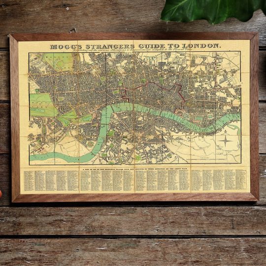
Hi there, Hello from London! 🤴🇬🇧 Wherever you are I hope you have a great week! ❤️ ⠀⠀⠀⠀⠀⠀⠀⠀⠀ Old Maps Library reprint map of London by Mogg’s. ⠀⠀⠀⠀⠀⠀⠀⠀⠀ Edward Mogg was a publisher in London in the 19th century. He issued maps and travel guides to London and other localities in England and Wales. ⠀⠀⠀⠀⠀⠀⠀⠀⠀ Mogg’s Strangers Guide to London Map was published in 1834. ⠀⠀⠀⠀⠀⠀⠀⠀⠀ Exhibiting All The Various Alterations & Improvements Complete To The Present Time. The map shows London with “a list of 500 of the principal places with references to their situation on the above plan”. Main streets and green spaces are coloured in, and the map also shows the boundary of the City of London. Coverage roughly: most of Regent’s Park – Pentoville Road – Hackney; Stepney – Surrey Docks; Kennington including part of The Oval; Royal Chelsea Hospital – most of Hyde Park. ⠀⠀⠀⠀⠀⠀⠀⠀⠀ Visit our website for more London maps. → www.oldmapslibrary.com . . . . . #oldmaps #vintagemaps #londonmap #antiquemaps #ilovegreatbritain #ancientbritain #amazingmaps (at London, Unιted Kingdom) https://www.instagram.com/p/Cj-H3k9IS4e/?igshid=NGJjMDIxMWI=
0 notes
Photo
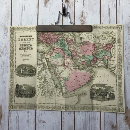
Happy Day! How about have in your home a beautiful historical map of your favourite place in the world? Just like this great map of Turkey in Asia, Persia Arabia & c. by Johnson and Ward, 1866 ⠀⠀⠀⠀⠀⠀⠀⠀⠀ This map of Arabia, Persia, and Turkey in Asia, covers from the Mediterranean and Egypt eastwards as far as the Mouths of the Indus River, as well as southward as far as the Horn of Africa and northwards to the Black Sea. Depicts most of the politically volatile modern-day middle east, including the nations of Afghanistan, Iraq, Iran, Saudi Arabia, Jordan, Israel, Syria, Lebanon, and Turkey. Offers color coding according to country and region as well as notations regarding desert caravan routes, oases, roadways, river systems, forts and monasteries, and some topographical features. ⠀⠀⠀⠀⠀⠀⠀⠀⠀ ⏳ Old Maps Library specialises in the reprint of Vintage Maps and Illustrations between the 17th to 19th centuries. 🔎 Our prints are linen backed by hand, this technique gives it more durability and a beautiful vintage finish look. ⏳Linen backing is a technique that mapmakers used in the past as a solution to keep the maps stronger for long journeys and weather changes. ⏳Our maps are folded and fitted into a marbled slipcase. ⠀⠀⠀⠀⠀⠀⠀⠀⠀ ⏳ ⠀⠀⠀⠀⠀⠀⠀⠀⠀ Are you also fascinated by old maps? ⠀⠀⠀⠀⠀⠀⠀⠀⠀ ⏳ ⠀⠀⠀⠀⠀⠀⠀⠀⠀ "Travel back to moments in time and discover the world heritage!" ⠀⠀⠀⠀⠀⠀⠀⠀⠀ ⏳ We have a beautiful collection of Old Maps and Vintage Illustrations on our website. Link on our bio. 🔝 . . . . . #mapsarecool #mapsofinstagram #mapsandillustrations #mapsoftheworld #oldword #antiquemapsandprints https://www.instagram.com/p/CjGIHOYI4nG/?igshid=NGJjMDIxMWI=
1 note
·
View note
Photo
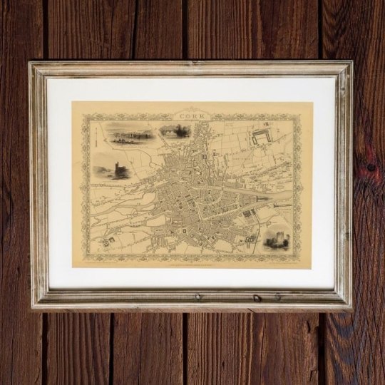
Hello! Happy Tuesday 😊 ⠀⠀⠀⠀⠀⠀⠀⠀⠀ Here for you today a gorgeous map of Cork, 1851 by John Tallis. This town plan includes vignettes of Blarney Castle, Black Rock Castle, Queenstown Harbour and Old Weir Bridge, Killarney. ⠀⠀⠀⠀⠀⠀⠀⠀⠀ 📍The city of Cork began as a monastic settlement, founded by St Finbar in the sixth century. However the ancestor of the modern city was founded between 915 and 922, when Viking settlers established a trading community. ⠀⠀⠀⠀⠀⠀⠀⠀⠀ For more maps like this one, check our online store. Link in Bio 🔝 . . . . . . . #maplove #lovemaps #mapshop #mapsoftheworld #oldword (at London, Unιted Kingdom) https://www.instagram.com/p/CjAa_-7okhy/?igshid=NGJjMDIxMWI=
0 notes
Photo
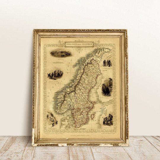
Hello you! Where is your favourite place in the world? Where is your dream destination? ⠀⠀⠀⠀⠀⠀⠀⠀⠀ Bring those memories or keep your travel dream alive with a beautiful old map like this one from SWEDEN & NORWAY, 1851 by John Tallis. ⠀⠀⠀⠀⠀⠀⠀⠀⠀ This map of Sweden and Norway has a number of vignette views including Stockholm, Swedish peasants and Norwegian Laplanders in winter dress, the iron mine of Dannemora and Norwegian ‘skielobere’, or Skate runners. The map was drawn and engraved by John Rapkin while the illustrations are drawn by J.Marchant and engraved by J. H. Kernot and published in John Tallis & co.’s The Illustrated Atlas. ⠀⠀⠀⠀⠀⠀⠀⠀⠀ "Travel back to moments in time and discover the world heritage!" ⠀⠀⠀⠀⠀⠀⠀⠀⠀ Visit our online store! www.oldmapslibrary.com . . . . #oldmapsarecool #walldecorideas #swedenmap #norwaymap #ilovemaps (at London, Unιted Kingdom) https://www.instagram.com/p/CixcK2hItpr/?igshid=NGJjMDIxMWI=
0 notes
Photo
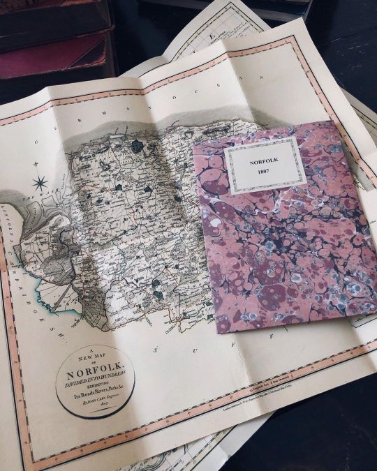
Happy Wednesday! ⠀⠀⠀⠀⠀⠀⠀⠀⠀ A gorgeous county map of of NORFOLK, 1807 by John Cary. Reprint Old Maps Library, 2022. ⠀⠀⠀⠀⠀⠀⠀⠀⠀ Norfolk is situated East Anglia in England, the county is a magnet for fans of the great outdoors, particularly bird watchers and boating enthusiasts. But there are so many other reasons to visit Norfolk . There are superb medieval churches, fascinating museums and stately homes, as well as lively seaside resorts and bags of entertainment for kids. ⠀⠀⠀⠀⠀⠀⠀⠀⠀ Did you know that people from Norfolk are sometimes known as Norfolk Dumplings, an allusion to the flour dumplings that were traditionally a significant part of the local diet. 🥟🏴 ⠀⠀⠀⠀⠀⠀⠀⠀⠀ ⏳Old Maps Library specialises in the reprint of Vintage Maps and Illustrations between the 17th to 19th centuries. ⠀⠀⠀⠀⠀⠀⠀⠀⠀ ⏳ We have a beautiful collection of Old Maps and Vintage Illustrations on our website. Link on our bio. . . . #oldmaps #vintagemaps #ilovehistory #countymaps #retromap (at London, Unιted Kingdom) https://www.instagram.com/p/CifdgJfo_-0/?igshid=NGJjMDIxMWI=
1 note
·
View note
Photo
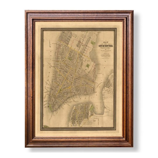
How you doing’? ⠀⠀⠀⠀⠀⠀⠀⠀⠀ Are you also a Friends fan? In the show, the Friends cast lived in New York's Greenwich Village neighbourhood in downtown Manhattan. ⠀⠀⠀⠀⠀⠀⠀⠀⠀ The place is located at 90 Bedford Street at the corner of Grove Street. Reaching the building used for the exterior shot of the Friends apartment building is relatively easy, thanks to a major subway junction less than a 10 minute walk away. ⠀⠀⠀⠀⠀⠀⠀⠀⠀ Old Maps Library reprint of a street map of the City of New York, drawn by D.H.Burr, for “New York as it is in 1834”. Published by J.Disturnell, no. 155 Broadway. New York. Engraved by Stiles & Co.New York. . . . . . #whoneedsamap #mapofnewyork #newyorkmap #oldmaps #instamaps (at London, Unιted Kingdom) https://www.instagram.com/p/CiH_5Xyofs8/?igshid=NGJjMDIxMWI=
0 notes
Photo
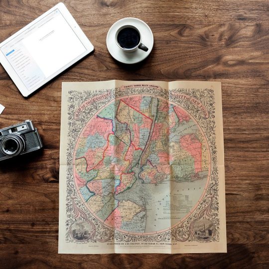
Happy Friday ! ⠀⠀⠀⠀⠀⠀⠀⠀⠀ Did you know that before New York was, well, New York – it was called New Amsterdam? It was a settlement by the Dutch that chose Manhattan for home. The Name, New York only came into being later in the 17th Century, chosen to pay tribute to Duke of York who helped capturing it. ⠀⠀⠀⠀⠀⠀⠀⠀⠀ This colourful reprint MAP OF THE COUNTRY THIRTY-THREE MILES AROUND THE CITY OF NEW YORK is of one of the most beautiful pocket maps of the city made in the 19th century: J.H Colton’s, 1847 map covers New York City and vicinity as far south as Ocean County, New Jersey, as far east as Suffolk County, as far north as Rockland County, and as far west as Somerset County. Surrounded by a splendid decorative border with engraved views depicting “City Hall, New York” and “City Hall, Brooklyn”. ⠀⠀⠀⠀⠀⠀⠀⠀⠀ ⏳Old Maps Library specialises in the reprint of Vintage Maps and Illustrations between the 17th to 19th centuries. ⠀⠀⠀⠀⠀⠀⠀⠀⠀ ⏳ We have a beautiful collection of Old Maps and Vintage Illustrations on our website. Link on our bio. . . #newyorkmap #mapofnewyork #newyorkcity #antiquemap #ancientmap (at London, Unιted Kingdom) https://www.instagram.com/p/Ch_8Peooqae/?igshid=NGJjMDIxMWI=
1 note
·
View note
Photo
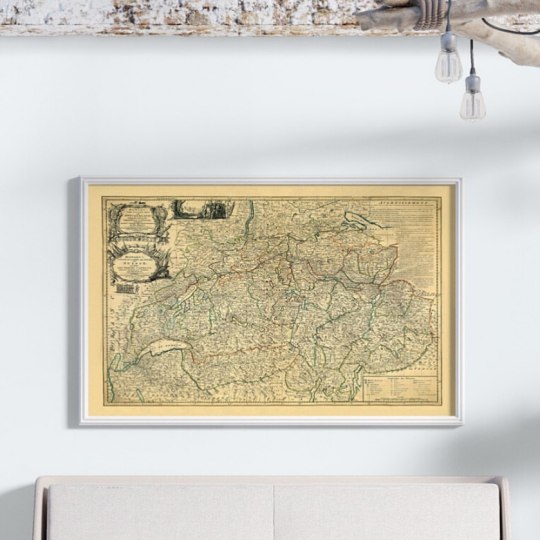
Hello there! ⠀⠀⠀⠀⠀⠀⠀⠀⠀ This place is a mountainous Central European country, home to numerous lakes, villages, and the high peaks of the Alps. Its cities contain medieval quarters, with landmarks like capital Bern’s Zytglogge clock tower and Lucerne’s wooden chapel bridge. The country is also known for its ski resorts and hiking trails. Banking, finance are key industries, and watches and chocolate are world-renowned. ⠀⠀⠀⠀⠀⠀⠀⠀⠀ Can you guess which country is it? 🇨🇭 🍫 ⌚️ 🧀 . . . ⠀⠀⠀⠀⠀⠀⠀⠀⠀ SWITZERLAND! Yes! Easy guess 🇨🇭😉 ⠀⠀⠀⠀⠀⠀⠀⠀⠀ Bowle’s New Pocket Map of Switzerland: comprehending the Thirteen Cantons, with their Allies & Subjected Territories. by Abr.Rouvier, 1794 ⠀⠀⠀⠀⠀⠀⠀⠀⠀ Reprint by Old Maps Library, 2020. ⠀⠀⠀⠀⠀⠀⠀⠀⠀ ⏳Old Maps Library specialises in the reprint of Vintage Maps and Illustrations between the 17th to 19th centuries. ⠀⠀⠀⠀⠀⠀⠀⠀⠀ ⏳ We have a beautiful collection of Old Maps and Vintage Illustrations on our website. 🔝 . . . . #haritalar #retromap #oldmapsandprint #whoneedsamap #mapsarecool #mapofswitzerland (at London, Unιted Kingdom) https://www.instagram.com/p/Ch4iVJcIe7r/?igshid=NGJjMDIxMWI=
0 notes
Photo
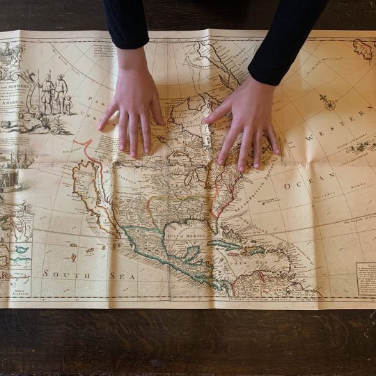
Happy Friday! ⠀⠀⠀⠀⠀⠀⠀⠀⠀ Take a journey back in time through this beautiful reproduction map of North America by Herman Moll, circa 1719. ⠀⠀⠀⠀⠀⠀⠀⠀⠀ One of Herman Moll’s most famous maps often referred to as The Codfish Map. ⠀⠀⠀⠀⠀⠀⠀⠀⠀ As an enhancement to his "Map of North America," Moll engraved orthographic or plan views of ten bays in North America and the Caribbean in the lower left-hand corner of the map. Each bay was the location of a major port city and harbor. Five of the port cities were British (St. John's, Boston, New York, Charleston, and Port Royal) and five were Spanish (Havana, Portobello, Vera Cruz, Cartagena, and Acapulco). Moll engraved the insets in the style of navigational charts complete with numbers on some of the charts representing depth soundings in fathoms. ⠀⠀⠀⠀⠀⠀⠀⠀⠀ Herman Moll (1654?-1732) was a London cartographer, engraver, and publisher. ⠀⠀⠀⠀⠀⠀⠀⠀⠀ ⏳ Old Maps Library specialises in the reprint of Vintage Maps and Illustrations between the 17th to 19th centuries. ⠀⠀⠀⠀⠀⠀⠀⠀⠀ 🔎 Our prints are linen backed by hand, this technique gives it more durability and a beautiful vintage finish look. ⠀⠀⠀⠀⠀⠀⠀⠀⠀ ⏳Linen backing is a technique that mapmakers used in the past as a solution to keep the maps stronger for long journeys and weather changes. ⠀⠀⠀⠀⠀⠀⠀⠀⠀ 🔎Nowadays, this technique is an important conservation method for restoring and preserving vintage maps and posters. ⠀⠀⠀⠀⠀⠀⠀⠀⠀ ⏳Our maps are folded and fitted into a marbled slipcase. ⠀⠀⠀⠀⠀⠀⠀⠀⠀ Visit our online store →www.oldmapslibrary.com . . . . #maplove #lovemaps #mapshop #mapsoftheworld #oldword #antiquemapsandprints #map (at London, Unιted Kingdom) https://www.instagram.com/p/ChuKqRpo1lP/?igshid=NGJjMDIxMWI=
0 notes
Photo

Forget yourself by exploring a gorgeous and unique old map! Get sucked in looking at the details and getting a glimpse of the past. See the world through the eyes of the cartographers, scientists, men of faith, and sovereigns have imprinted their dreams and drawn their ideas. ⏳🔎🗺 🧭 ⠀⠀⠀⠀⠀⠀⠀⠀⠀ ⠀⠀⠀⠀⠀⠀⠀⠀⠀ ⏳Old Maps Library specialises in the reprint of Vintage Maps and Illustrations between the 17th to 19th centuries. ⠀⠀⠀⠀⠀⠀⠀⠀⠀ ⏳ We have a beautiful collection of Old Maps and Vintage Illustrations on our website. Link in bio. 🔝 . . . . #whoneedsamap #mapsandatlases #mapa #oldmapslibrary #mapart (at London, Unιted Kingdom) https://www.instagram.com/p/ChsS01cozbk/?igshid=NGJjMDIxMWI=
0 notes
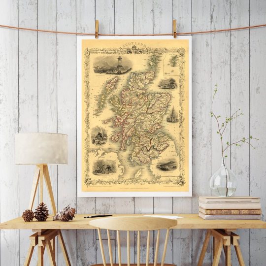
Photo
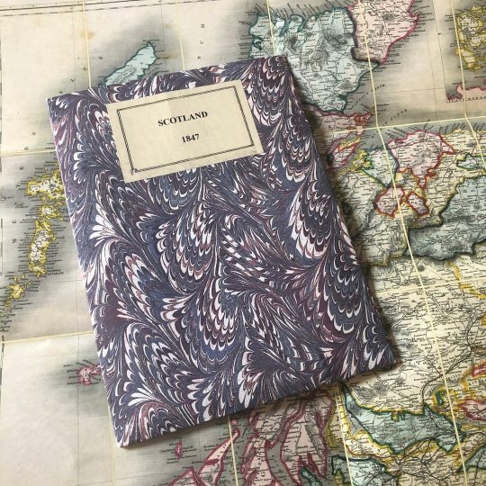
Awrite, beautiful Scotland! 🏴 "There are few places in my life that I’ve found more ruggedly beautiful than the Highlands of Scotland. The place is magical – it’s so far north, so remote, that sometimes it feels like you’ve left this world and gone to another." - Julia London ⠀⠀⠀⠀⠀⠀⠀⠀⠀ BETT’s new map of Scotland Embracing All the Principal Objects of Interests to the Tourist, And Shewing The Various Lines Of Railroad, The Turnpike, And Principal Cross Roads, Lakes, Rivers &c. Year 1847 ⠀⠀⠀⠀⠀⠀⠀⠀⠀ Old Maps Library reprint, 2022 Find this map on our website: www.oldmapslibrary.com . . . . . #mapsandglobes #scotlandmap #ancientmaps #oldmapsandprint #oldmapslibrary (at London, Unιted Kingdom) https://www.instagram.com/p/ChkNaVHI8-A/?igshid=NGJjMDIxMWI=
0 notes
Photo

Hello from London! "To walk alone in London is the greatest rest." - girl with the passport- ⠀⠀⠀⠀⠀⠀⠀⠀⠀ To celebrate this amazing city, a gorgeous old map. Cary’s New Accurate Plan of London and Westminster the Borough of Southwark and parts adjacent: viz.Kensington, Chelsea, Islington, Hackney, Walworth, Newington, etc with an Alphabetical list of upwards of 500 of the most principal streets with references to their situation. CARTOGRAPHER: John Cary, 1795. ⠀⠀⠀⠀⠀⠀⠀⠀⠀ ⏳ Old Maps Library specialises in the reprint of Vintage Maps and Illustrations between the 17th to 19th centuries. ⠀⠀⠀⠀⠀⠀⠀⠀⠀ 🔎 Our prints are linen backed by hand, this technique gives it more durability and a beautiful vintage finish look. ⠀⠀⠀⠀⠀⠀⠀⠀⠀ ⏳Linen backing is a technique that mapmakers used in the past as a solution to keep the maps stronger for long journeys and weather changes. ⠀⠀⠀⠀⠀⠀⠀⠀⠀ 🔎Nowadays, this technique is an important conservation method for restoring and preserving vintage maps and posters. ⠀⠀⠀⠀⠀⠀⠀⠀⠀ ⏳Our maps are folded and fitted into a marbled slipcase. ⠀⠀⠀⠀⠀⠀⠀⠀⠀ ⏳ ⠀⠀⠀⠀⠀⠀⠀⠀⠀ Are you also fascinated by old maps? ⠀⠀⠀⠀⠀⠀⠀⠀⠀ ⏳ ⠀⠀⠀⠀⠀⠀⠀⠀⠀ "Travel back to moments in time and discover the world heritage!" ⠀⠀⠀⠀⠀⠀⠀⠀⠀ Visit our online store for more like this! Link in Bio 🔝 ⠀⠀⠀⠀⠀⠀⠀⠀⠀ #londonmap #cityoflondon #riverthames #oldmaps #vintagemaps (at London, Unιted Kingdom) https://www.instagram.com/p/ChbrIobo1ta/?igshid=NGJjMDIxMWI=
0 notes
Photo
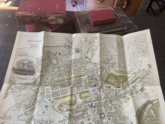
Happy Wednesday! ⠀⠀⠀⠀⠀⠀⠀⠀⠀ Every August takes place in Edinburgh, The Edinburgh Festival Fringe (also referred to as The Fringe, Edinburgh Fringe, or Edinburgh Fringe Festival), It is the world's largest arts festival! The first one was in 1947 as an alternative to the Edinburgh International Festival. The Edinburgh Festival Fringe has become a world-leading celebration of arts and culture, surpassed only by the Olympics and the World Cup in terms of global ticketed events! ⠀⠀⠀⠀⠀⠀⠀⠀⠀ Old Maps Library is there at the Fringe! If you are around Edinburgh come to visit us and check our unique old maps & vintage illustrations at the Arch's of Saint John’s Church, Prince Street @3d2devents West End Fair. ⠀⠀⠀⠀⠀⠀⠀⠀⠀ S.D.U.K 1834 Map or plane of the city of Edinburgh, Scotland by the Society for the Diffusion of Useful Knowledge. Centered on Old Town, it covers the city of Edinburgh, know as the “Athens of the North” in exceptional detail, noting individual streets, buildings, rivers, squares and parks. A beautiful illustration of Edinburgh Castle is included along the left border, below the title. The lower border depicts the many important monuments and buildings in profile. These include the Observatory, the Old High School, St. Giles’s Church, St. John’s Chapel, Assembly Rooms, Colton Jail, etc. ⠀⠀⠀⠀⠀⠀⠀⠀⠀ #oldmapslibrary #fringefestival #3d2devents #oldmaps #shoplocal #westendfair (at Edinburgh, Scotland) https://www.instagram.com/p/ChWh_TKo3Hf/?igshid=NGJjMDIxMWI=
0 notes
Photo

Hello Everyone! Do you think is it possible to travel Around the World in 80 Days, just like in the adventure novel of Jules Verne? In the story Phileas Fogg of London and his newly employed French valet Passepartout attempt to circumnavigate the world in 80 days. ⠀⠀⠀⠀⠀⠀⠀⠀⠀ The answer is, Yes! Nowadays with modern flight, going round the world in 80 days wouldn't only be possible, but could be done 40 times over. ⠀⠀⠀⠀⠀⠀⠀⠀⠀ Old Maps Library reprint map of the World on Mercator’s Projection. Revised and Improved to 1817 by John Melish. Published by John Melish & Samil.Harrison. Includes text “To find the distance of one place from another” and statistical table. ⠀⠀⠀⠀⠀⠀⠀⠀⠀ This exquisite World map and many others can be found at our website, link in Bio 🔝 . . . . . . . #maplove #lovemaps #mapshop #mapsoftheworld #oldword #antiquemapsandprints #oldmapslibrary #mapasantiguos (at London, Unιted Kingdom) https://www.instagram.com/p/ChSh8DUod5i/?igshid=NGJjMDIxMWI=
0 notes
Photo
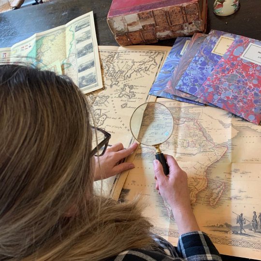
Hello Map lovers! ⠀⠀⠀⠀⠀⠀⠀⠀⠀ Nowadays, when satellite images and GPS Services offer incredibly accurate images of the Earth's surface, we can easily forget that most human history has been an unknown tabula rasa on which Cartographers, scientists, men of faith, and sovereigns have imprinted their dreams and drawn their ideas. ⠀⠀⠀⠀⠀⠀⠀⠀⠀ Ancient maps are where we can see the birth of the modern world through the eyes of the historian. It is undeniable that offer us adventure, lessons in politics, history, and philosophy, and a panorama of artistic creativity unsurpassed in sheer beauty of form. ⠀⠀⠀⠀⠀⠀⠀⠀⠀ So, as Kevin J. Brown wrote in his book, A Journey Back in Time Through Maps, "Ancient maps are a touching reminder that our knowledge and our perception of the world are abundant and limited at the same time.” ⠀⠀⠀⠀⠀⠀⠀⠀⠀ ⏳Old Maps Library specialises in the reprint of Vintage Maps and Illustrations between the 17th to 19th centuries. ⠀⠀⠀⠀⠀⠀⠀⠀⠀ ⏳ We have a beautiful collection of Old Maps and Vintage Illustrations on our website. Link on our bio. . . . . . . . . #oldmap #vintagemap #raremap #cartographer #antiquemap #ancientmap #gallerywalldecor #mapas #instamap (at London, Unιted Kingdom) https://www.instagram.com/p/ChIBqYKIkZa/?igshid=NGJjMDIxMWI=
0 notes
Photo
Hello there! A gorgeous map of this gorgeous country, SCOTLAND, 1851 by John Tallis. Illustrated are views of Edinburgh, Brig of Doon and Burn’s Monument, Scott’s Monument, Holyrood House, hunters stalking deer, and Scots in national costume playing shinty. ⠀⠀⠀⠀⠀⠀⠀⠀⠀ Old Maps Library is this whole month in Edinburgh #fringefestival with @3d2devents in the arch's of Saint Johns Church, Prince Street. Come to visit us and check our Old Maps & Vintage Illustrations. . . . . #scotlandmap #3d2devents #oldmapslibrary #oldmaps #mapofscotlandshape (at London, Unιted Kingdom) https://www.instagram.com/p/ChC_8bgIcKj/?igshid=NGJjMDIxMWI=
0 notes