
Last Seen Blogs

story-and-song
Hot For Hollis™

moltenfreddy15
Molten

walking-error
Kitchen Sink

couldawouldashoulda50
just tripping along

cuartetocultural
Crónicas culturales
Photo
Civil aviation
Scheduled airline traffic in 2009 Civil aviation is one of two major categories of flying, representing all non-military aviation, both private and commercial. Most of the countries in the world are members of the International Civil Aviation Organization (ICAO) and work together to establish common standards and recommended practices for civil aviation through that agency. Civil aviation includes two major categories: Scheduled air transport, including all passenger and cargo flights operating on regularly scheduled routes; and General aviation (GA), including all other civil flights, private or commercial Although scheduled air transport is the larger operation in terms of passenger numbers, GA is larger in the number of flights (and flight hours, in the U.S.) In the U.S., GA carries 166 million passengers each year, more than any individual airline, though less than all the airlines combined. Since 2004, the US Airlines combined have carried over 600 million passengers each year, and in 2014, they carried a combined 662,819,232 passengers. Some countries also make a regulatory distinction based on whether aircraft are flown for hire like: Commercial aviation includes most or all flying done for hire, particularly scheduled service on airlines; and Private aviation includes pilots flying for their own purposes (recreation, business meetings, etc.) without receiving any kind of remuneration. A British Airways Boeing 747-400 departs London Heathrow Airport. This is an example of a commercial aviation service. All scheduled air transport is commercial, but general aviation can be either commercial or private. Normally, the pilot, aircraft, and operator must all be authorized to perform commercial operations through separate commercial licensing, registration, and operation certificates.
More details Android, Windows
0 notes
Photo

Pressure suit
For diving suits that protect against excessively high pressure, see Atmospheric diving suit. For the positive pressure suit used in biocontainment, see Positive pressure personnel suit. A U-2 pilot suit A pressure suit is a protective suit worn by high-altitude pilots who may fly at altitudes where the air pressure is too low for an unprotected person to survive, even breathing pure oxygen at positive pressure. Such suits may be either full-pressure (i.e. a space suit) or partial-pressure (as used by aircrew). Partial-pressure suits work by providing mechanical counter-pressure to assist breathing at altitude.
More details Android, Windows
0 notes
Photo

Altitude
For other uses, see Altitude (disambiguation). Not to be confused with Attitude. Altitude or height (sometimes known as depth) is defined based on the context in which it is used (aviation, geometry, geographical survey, sport, and more). As a general definition, altitude is a distance measurement, usually in the vertical or "up" direction, between a reference datum and a point or object. The reference datum also often varies according to the context. Although the term altitude is commonly used to mean the height above sea level of a location, in geography the term elevation is often preferred for this usage. Vertical distance measurements in the "down" direction are commonly referred to as depth.
More details Android, Windows
0 notes
Text
Density altitude
Density Altitude Computation Chart Density altitude is the altitude relative to the standard atmosphere conditions (ISA) at which the air density would be equal to the indicated air density at the place of observation. In other words, density altitude is air density given as a height above mean sea level. "Density altitude" can also be considered to be the pressure altitude adjusted for non-standard temperature. Both an increase in temperature, decrease in atmospheric pressure, and, to a much lesser degree, increase in humidity will cause an increase in density altitude. In hot and humid conditions, the density altitude at a particular location may be significantly higher than the true altitude. In aviation, the density altitude is used to assess the aircraft's aerodynamic performance under certain weather conditions. The lift generated by the aircraft's airfoils and the relation between indicated and true airspeed are also subject to air density changes. Furthermore, the power delivered by the aircraft's engine is affected by the air density and air composition.
More details Android, Windows
0 notes
Text
Flight level#Transition altitude
A flight level (FL) is specific barometric pressure, expressed as a nominal altitude in hundreds of feet. The pressure is computed assuming an International standard sea-level pressure datum of 1013.25 hPa (29.92 inHg), and therefore is not necessarily the same as the aircraft's true altitude either above mean sea level or above ground level.
More details Android, Windows
0 notes
Photo
Forced landing
For the 1941 film, see Forced Landing (film). A forced landing is a landing by an aircraft made under factors outside the pilot's control, such as the failure of engines, systems, components or weather which makes continued flight impossible. For a full description of these, see article on emergency landing. However the term also means a landing that has been forced by interception. A plane may be compelled to land through the use, or threat of use, of force, if it strays off course into hostile foreign territory. The customary procedure is for the military plane to approach the airliner from below and to the left, where his plane is easily visible from the left seat where the captain sits. The forcing plane waggles his wings to signal the demand for a forced landing. International law regulates the treatment of intruding aircraft: ... aircraft that fail to identify themselves, enter the airspace without a necessary permission, deny to follow a prescribed route, head towards a prohibited zone, or violate of a prohibition of flight may, by strict observance of the relevant standards and procedures, as a last resort, be intercepted, identified, escorted to the adequate route or out of the prohibited airspace, or forced to land by military aircraft of the territorial state. ^ ... the international requirements for making an intruding plane follow an air-force escort to the ground – moving in front and to the left, where the civilian pilot can see the escort, and waggling the fighter's wings. The Washingtonian November, 1985 – Page 153-154 ^ An Assessment of the Destruction of Rogue Civil Aircraft under International Law and Constitutional Law
More details Android, Windows
0 notes
Photo

Distance measuring equipment
This article is about usage in aviation. For distance measurement in general, see rangefinder. D-VOR/DM一E ground station DME antenna beside the DME transponder shelter Distance measuring equipment (DME) is a transponder-based radio navigation technology that measures slant range distance by timing the propagation delay of VHF or UHF radio signals. Developed in Australia, it was invented by James "Gerry" Gerrand under the supervision of Edward George "Taffy" Bowen while employed as Chief of the Division of Radiophysics of the Commonwealth Scientific and Industrial Research Organisation (CSIRO). Another engineered version of the system was deployed by Amalgamated Wireless Australasia Limited in the early 1950s operating in the 200 MHz VHF band. This Australian domestic version was referred to by the Federal Department of Civil Aviation as DME(D) (or DME Domestic), and the later international version adopted by ICAO as DME(I). DME is similar to secondary radar, except in reverse. The system was a post-war development of the IFF (identification friend or foe) systems of World War II. To maintain compatibility, DME is functionally identical to the distance measuring component of TACAN.
More details Android, Windows
0 notes
Photo

VHF omnidirectional range
DVOR (Doppler VOR) ground station, collocated with DME. On-board VOR display with CDI VHF Omni Directional Radio Range (VOR) is a type of short-range radio navigation system for aircraft, enabling aircraft with a receiving unit to determine their position and stay on course by receiving radio signals transmitted by a network of fixed ground radio beacons. It uses frequencies in the very high frequency (VHF) band from 108 to 117.95 MHz. Developed in the United States beginning in 1937 and deployed by 1946, VOR is the standard air navigational system in the world, used by both commercial and general aviation. By 2000 there were about 3,000 VOR stations around the world including 1,033 in the US, reduced to 967 by 2013 with more stations being decommissioned with the widespread adoption of GPS. A VOR ground station sends out an omnidirectional master signal, and a highly directional second signal is propagated by a phased antenna array and rotates clockwise in space 30 times a second. This signal is timed so that its phase (compared to the master) varies as the secondary signal rotates, and this phase difference is the same as the angular direction of the 'spinning' signal, (so that when the signal is being sent 90 degrees clockwise from north, the signal is 90 degrees out of phase with the master). By comparing the phase of the secondary signal with the master, the angle (bearing) to the aircraft from the station can be determined. This line of position is called the "radial" from the VOR. The intersection of radials from two different VOR stations can be used to fix the position of the aircraft, as in earlier radio direction finding (RDF) systems. VOR stations are fairly short range: the signals are useful for up to 200 miles. Each station broadcasts a VHF radio composite signal including the navigation signal, station's identifier and voice, if so equipped. The navigation signal allows the airborne receiving equipment to determine a bearing from the station to the aircraft (direction from the VOR station in relation to Magnetic North). The station's identifier is typically a three-letter string in Morse code. The voice signal, if used, is usually the station name, in-flight recorded advisories, or live flight service broadcasts. At some locations, this voice signal is a continuous recorded broadcast of Hazardous Inflight Weather Advisory Service or HIWAS.
More details Android, Windows
0 notes
Text
Air corridor
Redirect to: Airway (aviation)#Air corridor
More details Android, Windows
0 notes
Photo
Aircraft
"Flying machine" redirects here. For other uses, see Flying machine (disambiguation). NASA test aircraft The Mil Mi-8 is the most-produced helicopter in history Voodoo, a modified P 51 Mustang is the 2014 Reno Air Race Champion An aircraft is a machine that is able to fly by gaining support from the air. It counters the force of gravity by using either static lift or by using the dynamic lift of an airfoil, or in a few cases the downward thrust from jet engines. The human activity that surrounds aircraft is called aviation. Crewed aircraft are flown by an onboard pilot, but unmanned aerial vehicles may be remotely controlled or self-controlled by onboard computers. Aircraft may be classified by different criteria, such as lift type, aircraft propulsion, usage and others.
More details Android, Windows
0 notes
Photo

Air navigation
A relatively modern Boeing 737 Flight Management System (FMS) flight deck unit, which automates many air navigation tasks The basic principles of air navigation are identical to general navigation, which includes the process of planning, recording, and controlling the movement of a craft from one place to another. Successful air navigation involves piloting an aircraft from place to place without getting lost, breaking the laws applying to aircraft, or endangering the safety of those on board or on the ground. Air navigation differs from the navigation of surface craft in several ways; Aircraft travel at relatively high speeds, leaving less time to calculate their position on route. Aircraft normally cannot stop in mid-air to ascertain their position at leisure. Aircraft are safety-limited by the amount of fuel they can carry; a surface vehicle can usually get lost, run out of fuel, then simply await rescue. There is no in-flight rescue for most aircraft. Additionally, collisions with obstructions are usually fatal. Therefore, constant awareness of position is critical for aircraft pilots. The techniques used for navigation in the air will depend on whether the aircraft is flying under visual flight rules (VFR) or instrument flight rules (IFR). In the latter case, the pilot will navigate exclusively using instruments and radio navigation aids such as beacons, or as directed under radar control by air traffic control. In the VFR case, a pilot will largely navigate using "dead reckoning" combined with visual observations (known as pilotage), with reference to appropriate maps. This may be supplemented using radio navigation aids.
More details Android, Windows
0 notes
Photo

Military air base
For the Swedish DJ and musician known as "Airbase", see Airbase (DJ). Part of Spangdahlem Air Base in 1990 Osan Air Base, an air base shared by United States Air Force and Republic of Korea Air Force in South Korea. A military air base (sometimes referred to as a military airfield, military airport, air force station, air force base or short air base) is an aerodrome used by a military force for the operation of military aircraft.
More details Android, Windows
0 notes
Photo

Air force
For other uses, see Air Force (disambiguation) and list of air forces. For military aviation conducted by armies and navies, see army aviation and naval aviation. Four fighters and a tanker aircraft of the USAF. USAF B-2 Spirit stealth strategic bomber. Refuelling a Jaguar GR1 of the Royal Air Force (1991). An air force, also known in some countries as an air army, is in the broadest sense, the national military organization that primarily conducts aerial warfare. More specifically, it is the branch of a nation's armed services that is responsible for aerial warfare as distinct from an army, navy, or a marine corps. Typically, air forces are responsible for gaining control of the air, carrying out strategic and tactical bombing missions, and providing support to land and naval forces. The term "air force" may also refer to a tactical air force or numbered air force, which is an operational formation either within a national air force or comprising several air components from allied nations. Air forces typically consist of a combination of fighters, bombers, helicopters, transport planes and other aircraft. Many air forces are also responsible for operations of the military space, intercontinental ballistic missiles (ICBM), and communications equipment. Some air forces may command and control other air defence assets such as anti-aircraft artillery, surface-to-air missiles, or anti-ballistic missile warning networks and defensive systems. Some nations, principally Russia, the former Soviet Union and countries who modelled their militaries along Soviet lines, have an air defence force which is organizationally separate from their air force. In addition to pilot, air forces have ground support staff who support the aircrew. In a similar manner to civilian airlines, there are supporting ground crew as pilots cannot fly without the assistance of other personnel such as engineers, loadmasters, fuel technicians and mechanics. However, some supporting personnel such as airfield defence troops, weapons engineers and air intelligence staff do not have equivalent roles in civilian organizations.
More details Android, Windows
0 notes
Photo
Military aviation
For the effects of military aviation on warfare, see Aerial warfare. An American F-14 fighter intercepting a Russian Tu-95 long range nuclear bomber Military aviation is the use of military aircraft and other flying machines for the purposes of conducting or enabling aerial warfare, including national airlift (air cargo) capacity to provide logistical supply to forces stationed in a theater or along a front. Airpower includes the national means of conducting such warfare, including the intersection of transport and war craft. Military aircraft include bombers, fighters, transports, trainer aircraft, and reconnaissance aircraft.
More details Android, Windows
0 notes
Photo

Takeoff
For other uses, see Takeoff (disambiguation). An F/A-18 taking off from an aircraft carrier An Embraer E-175 takes off Takeoff is the phase of flight in which an aerospace vehicle goes from the ground to flying in the air. For aircraft that take off horizontally, this usually involves starting with a transition from moving along the ground on a runway. For balloons, helicopters and some specialized fixed-wing aircraft (VTOL aircraft such as the Harrier), no runway is needed. Takeoff is the opposite of landing.
More details Android, Windows
0 notes
Photo
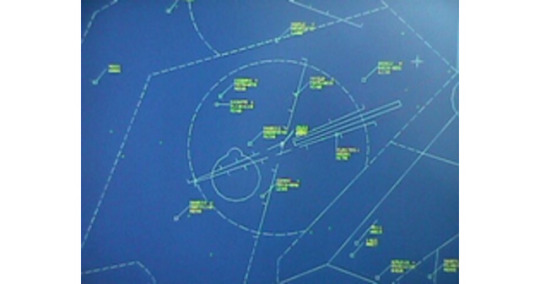
Aircraft vectoring
Aircraft vectoring is a navigation service provided to aircraft by air traffic control. The controller decides on a particular airfield traffic pattern for the aircraft to fly, composed of specific legs or vectors. The aircraft then follows this pattern when the controller instructs the pilot to fly specific headings at appropriate times. Vectoring is used to separate aircraft by a specified distance, to aid the navigation of flights, and to guide arriving aircraft to a position from which they can continue their final approach to land under the guidance of an approach procedure published by the FAA. Vectoring is the provision of navigational guidance to aircraft in the form of specific headings, based on the use of an ATS surveillance system. Aircraft may be vectored to; apply ATS surveillance system separation achieve an expeditious flow of aircraft maximise use of available airspace comply with noise abatement procedures avoid areas of known hazardous weather or known severe turbulence. adjust the arrival sequence establish the aircraft on final approach track of a pilot-interpreted approach manoeuvre an aircraft into a suitable position below the clouds near an aerodrome for a visual approach and landing. The nature of Terminal area operations means that vectoring plays a significant part in the way controllers’ process traffic.[citation needed]
More details Android, Windows
0 notes
Photo

Pushback
For information on border control operations, see Non-refoulement. An El Al Boeing 737-800 on pushback at Zürich Airport In aviation, pushback is an airport procedure during which an aircraft is pushed backwards away from an airport gate by external power. Pushbacks are carried out by special, low-profile vehicles called pushback tractors or tugs. Although many aircraft are capable of moving themselves backwards on the ground using reverse thrust (a procedure referred to as a powerback), the resulting jet blast or prop wash may cause damage to the terminal building or equipment. Engines close to the ground may also blow sand and debris forward and then suck it into the engine, causing damage to the engine. A pushback is therefore the preferred method to move the aircraft away from the gate.
More details Android, Windows
0 notes