
Last Seen Blogs

eentransformatie
Kritische kijk op cureren

kannibaleherzen
~ weekend at mort's ~

vs-stardream
my name? gooey? maybe?

oyuujin
Illustrations by Zelda Oh

deathstardroid
deathstardroid
Text
POLE POSITION
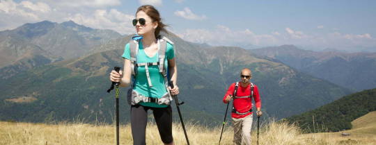
I recently completed a 2-month traverse of the Pyrenees Mountains, walking from the Atlantic to the Mediterranean via the High Route or HRP (Haute Route Pyrenees) between France and Spain. During my time on these trails, I was struck by how many people were using trekking poles – not just the serious long-distance walkers, but also families out for day walks, and mountain runners on uphill sections.
This is clearly quite different from the situation in Australia, where trekking poles (also known as walking or hiking poles) are used by only a small percent of walkers. What do the Europeans know that we don’t?! What can we learn from them?
First, there is a very different mindset in Europe. Trekking poles are seen as a way of boosting your fitness while walking (an activity also sometimes referred to as “Nordic Walking”) and having poles is part and parcel of being a serious walker; not just looking the part but having the right gear. Their usefulness in taking some of the strain off your knees, helping with shock absorption on steep, rocky ground – both uphill and downhill, assisting with tricky, balance bits of the track, and enhancing your upper body workout, is widely recognised. They are even marketed to kids!
Here in Australia, it’s a bit different. Walking poles are often called “walking sticks” which confuses the situation. Technically, a walking stick is something quite different – often a single wooden stick to assist with mobility. Given this association, I have found that if you suggest to someone in Australia that they might benefit from using poles, it may be taken as an age-related insult. Even Australian walking guides can be guilty of this attitude! And if you do use walking/trekking poles, how often do you encounter a comedian (without poles of course) who asks you where the snow is?!
It’s high time for Australian walkers to get serious about trekking poles. Yes, you can walk without poles. You can eat without a knife and fork too but good technology is worth using. After a few hours on the trail, your knees (and hips) will thank you for using poles. You’ll also have a far better walking posture (think shoulders, back, abdominals, triceps), your pack will sit and feel better on your back as a result, and no more “puffy sausage fingers” which you often get with walking if your hands are just hanging down by your sides. If even European mountain runners think poles are a vital piece of equipment on the hills, using them can only be a positive thing. An orthopaedic surgeon reputedly told a keen walking friend of mine (read “serious hardcore trekker”) that using poles would add about 10 years to the walking life of his knees. That sounds good to me!
I want to keep walking as long as I possibly can. I definitely use poles and have done since my mid-thirties, when I started using them to enhance the walking I was doing for fitness. I’ve never looked back. With every little thrust of the poles, I’m pushed along the track almost effortlessly. My poles were indispensable during my recent walk through the Pyrenees, and I will definitely be taking them along for my walk along the UK Coast to Coast Path next week!
0 notes
Text
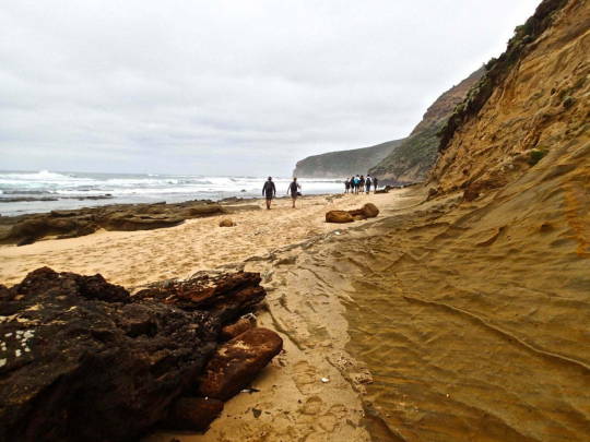
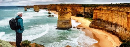
THE GREAT OCEAN WALK & A GREAT AUSTRALIAN STORY
The story of a place is often lost in time, leaving us to drift through unaware of the past. Or we’re left with names and dates, that don’t really tell us very much.
Which is a shame, as there are lessons to be learned from the past, and behind every dry historical fact there’s often a genuine human story begging to be told. If only we knew who to talk to, and what questions to ask.
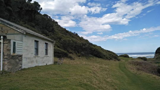
On the Great Ocean Walk, for example, when you finally reach the remote, and beautiful, Milanesia Beach, you may notice a little house nestled comfortably into the landscape. Just beyond the grasses at the edge of the beach, it’s white stone walls in stark contrast to the dark green forest rising steeply behind it.
And you may, with a little imagination, be able to see a family spending time there.
“…digging up worms in the sand, using them to catch trout, or eels that dad used to catch sharks while mum was off looking for crayfish. Everything cooked over a bonfire at night, and a game of cricket the next day before heading back to the homestead up the hill, where normal life resumed…”
Yes on looking at that picturesque little cottage, you can easily picture those idyllic family moments playing out in front of those cheery white walls. And you’d be right. That is what happened there, and still does.
What you’d never guess, however, is why that little house was built in the first place. You’d never guess that it was built by a father, to honour his son, who died on the battlefield at Gallipoli when he was only 22 years of age…

A young man goes to war
Eliot Gratton Wilson was working on a cattle station when the first world war began. He was 21, and, you can imagine, full of adventure, as only seven weeks later he signed up, enlisted in the Army and joined the 8th Australian Light Horse Regiment.
On the 25 February 1915 he boarded the Star Of Victoria and sailed to Egypt, and soon after his Regiment was sent to Gallipoli, where he led one of the first waves of attack in the infamous, and deadly, Battle of the Nek.
War correspondent and official Australian historian, Charles Bean, described the fact that anyone reached the enemy trenches in that initial assault, was a miracle. Yet two soldiers did exactly that, and one of them was Eliot.
‘On the other flank, near the seaward cliff, Lieutenant Wilson of the 8th [Light Horse Regiment] also reached the enemy’s trench and was seen sitting with his back to the parapet, beckoning to others to come to him. Shortly afterwards he was killed by a bomb from the Turkish line.’
Lieutenant Wilson died on the 7th August 1915, twelve days short of his 23rd birthday, in a battle that came to be known as ‘one of the bravest actions in the history of the war’. He died along with nine other officers in that charge, and by the time it was over, 154 of the 300 men in his Regiment were dead too. Gone too soon, every single one of them.
A father follows him
John Gratton Wilson was a doctor, politician, farmer, husband and a father, and he was 50 years old when he heard of his son’s death. And, while you never know what goes through a person’s mind when tragedy strikes, perhaps, the fact that he enlisted himself a couple of years later, even at that age, provides some indication of his mindset.
Doctor Wilson served, and survived two years of active duty in the war, and then returned home to build a humble beach house to honour his son. He went on to live a long and full life, passing on at the age of 85, and he’s buried in the Moonlight Heads Cemetery that you’ll also pass, on the Great Ocean Walk.
Now there’s no way you could know any of that, of course, and neither would we if it wasn’t for Georgie Beale, who spent her childhood running around Milanesia Beach, whose great grandfather built that little house, and who we’re very thankful to, for sharing her stories with us.
Growing up on the beach
Her family has lived there for six generations now. They’ve witnessed the changes through time, and often been active participants in the events that have shaped the landscape.
Growing up in a place like that, it seems, sends you in a certain direction in life. Georgie has spent most of her time in conservation and coastal management. She created education programs, bringing school groups down to the coast, showing them what there is to protect in this wild and rugged place.
And now she’s a guide for Auswalk. Taking people along the Great Ocean Walk, sharing the knowledge gained over a lifetime on the coast, and little bits of family history too.
“I feel like this is an accumulation of everything I’ve done, it’s just perfect and I love it.”
“The natural beauty of the place, and the ocean has a strong draw for me. Growing up we quickly learned to both read, and respect the ocean, as it could be very calm and soothing one minute, then wild and dangerous the next.”
The shipwreck coast
Of course, it’s been a wild and dangerous ocean since long before Georgie came along. When sailing to Australia from the ‘old world’, you’d head south along the coast of Africa to begin with, perhaps re-provision in Cape Town, and then prepare yourself for a wild ride as you drop into the roaring 40s, and fly east towards Australia.
When you finally popped out of this highway of the sea, if you were heading toward the east coast you’d be faced with a choice. Go north of King Island, or keep it to your port side and approach the continent further along.
Heading north became known as threading the needle, and it’s a decision that sent 638 ships to the bottom of the sea, that we know of anyway. Indeed Matthew Flinders, who’d seen a fair few things in his day, said he had ‘seldom seen a more fearful section of coastline.’
The Great Ocean Walk takes you along this particularly brutal stretch of water, and there are reminders of the shipwrecks all along, from place names and cemeteries, to actual anchors sticking out of the rock.
Once again there are stories behind it all, and you’ll discover many of them on your way as you walk the 104kms from Apollo Bay on the East, to Port Campbell on the West.
And, surprise surprise, Georgie’s family were involved too…

The wreck of the Fiji
The Fiji left Hamburg on the 22nd of May 1891, bound for Melbourne with a cargo of dynamite, whisky and 400 pianos – amongst other less interesting items. Almost four months later Captain Julius Gebauer was the first to swim ashore after she sank, just off Wreck Beach, ironically enough.
Georgie’s great, great grandparents, Christopher Hodgson and Emily Bowker, had obviously witnessed the event and were there to help rescue the survivors.
The good Captain took a shine to their daughter, Ada, and later on referred to her as ‘the girl who first set his heart aflutter’. Unfortunately his advances were not welcomed by the family, but he was infatuated with Ada, and it must have been reciprocated to some extent as they corresponded over the years, sending letters back and forth until the end.
Letters that Georgie still has to this day, a reminder that history is made by ordinary people, doing extraordinary things, driven by love, honour, duty, family and sacrifice. The same emotions that move us today, and, I think, help us connect to history, and truly bring it to life.
As Rudyard Kipling said, “If history were taught in the form of stories, it would never be forgotten.”. I couldn’t agree more.
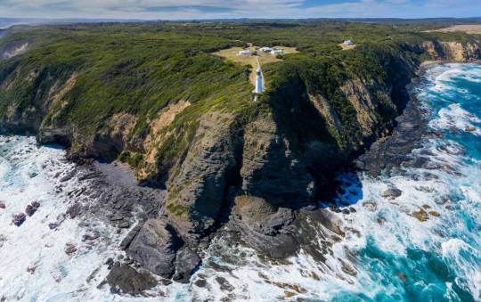
Cape Otway Lighthouse
Eventually, and not before time, someone decided it would be a good idea to build a lighthouse at Cape Otway, to try and prevent all of these disastrous shipwrecks that were happening on a frequent basis.
You’ll reach it only a few days after starting the walk, and to get there you’ll make your way through the Great Otway National Park, surrounded by some of the most magnificent trees on the planet, the enormous Eucalypts known as Mountain Ash.
Standing tall, and straight, the highest Mountain Ash reaches almost 100 metres into the sky, and only the Coastal Redwoods in Northern California can put them in the shade.
That might not always have been the case though. It’s possible a Mountain Ash was once the tallest tree in the world, but unfortunately, many of the true giants were cut down in the 1800s. They were so big, in fact, that many of their stumps were simply too big to remove. Keep an eye open, you might be able to spot one slowly disappearing into the undergrowth as you head to the Lighthouse…

Built in 1848, the Cape Otway Lightstation was the second lighthouse built on the Australian mainland, and although it was decommissioned in 1994, it’s still the oldest working lighthouse on the mainland too.
There’s an interesting museum that’s worth a visit when you get there, however if you’re completing your trip anytime between June and September, nature puts on a much better show out to sea.
Cast your gaze to the horizon, and chances are you’ll see Southern Right Whales on their way to the warm waters of South Australia, and, if you’re lucky, Humpback whales breaching in the distance.
Now we couldn’t possibly leave the lighthouse, without more of Georgie’s family getting a look in. This time her grandparents, Bill and Ada Gratton Wilson, who were the first to take a car out there, following the Old Coach road that the bullock team used to take supplies out to the Cape.
They drove their Model T Ford on the rocky road, carrying a picnic, car chains and an axe, and when they made it there they were given a nights accommodation in the lighthouse for their troubles.

A natural wonderland
Of course, when you take a week or so to complete the Great Ocean Walk, most of the time you’ll be surrounded by a wild, enduring landscape that simply doesn’t care about history, or the people who once lived there.
A wide variety of native species continue to go about their business, and you’ll see koalas, kangaroos, echidnas, cockatoos, snakes, lizards, eagles, seals and penguins. The natural environment is the overriding wonder in this Great story of the Southern Ocean, but you’ll get to know that story when you walk here anyway.
Some other stories, well, you’d never find out otherwise, and then you’d never learn from the past. And the lesson for me, at least, rests in the walls of that little beach house.
All I can think of, is, what a lovely way to honour the fallen. Not with a memorial that you visit sombrely once a year, lay a wreath and pause for a minute’s silence.
Instead, build a house by a beach. Fill it with your family whenever you can, and spend a lifetime creating memories. A house that’s handed down over the generations – creating a space, in a beautiful place, for years to come. Surely that’s a legacy we’d all like to create.
Eliot Gratton Wilson. Born on the 12th August 1892. Died on the 7th August 1915.
Lives on forever in the walls of a beach house, and in the hearts of his family.
So the next time you walk past that idyllic setting, spare a thought for Eliot, and all the soldiers who gave their todays, for our tomorrow.
#groupguided#selfguided#tours#australiawalks#trails#nature#walks#great ocean road#great ocean walk#great ocean tours
0 notes
Text
THE GREAT OCEAN WALK: A COMPREHENSIVE GUIDE
One of Victoria’s greatest walking tracks is the Great Ocean Walk. As it wraps around the coastline of the Southern Ocean, it gives those walking along it the rare opportunity to immerse themselves in this monumental location’s landscape, wildlife, and history. From sweeping ocean views to hidden rainforests, there is something for everyone.
For local and international visitors planning to travel along the Great Ocean Walk, many things are worth knowing before you set off. We have compiled a guide that will give you an insight into the location, what you can expect throughout your journey, and the important considerations to make as you plan.
The walk begins in Apollo Bay, a town in southwestern Victoria. Apollo Bay is a stop on the Great Ocean Road that winds along the coast, passing through the Great Otway National Park. Behind Apollo Bay are the mountains of Otway Ranges, partly forested and cleared for grazing and dairying. When you reach Apollo Bay, keep your eyes peeled for Apollo Bay Visitor Centre, as this will serve as the starting point for your journey.
Arrange your transportation from the end of your walk, Port Campbell, back to Apollo Bay (or where you have chosen to park your car). Shuttle services and public transport are available; we suggest organising your preferred transportation option before setting off.
The Great Ocean Walk is often travelled across eight days, allowing travellers to slow down and appreciate the sounds and sights at a gentle pace. There are also daily and multi-day trip options for covering the entire distance in a shorter timeframe.
Camping and lodge accommodations are available for those covering the distance over several days. Seven camping sites have been designed to be reached at the end of a daily hike, approximately ten to sixteen kilometres apart. To secure a camping spot or lodge, check availability ahead of time and book your accommodation.
The majestic locations available as you traverse the Great Ocean Walk can be separated into eight sections:
One: Apollo Bay to Elliot Ridge
Two: Elliot Ridge to Blanket Bay
Three: Blanket Bay to Cape Otway
Four: Cape Otway to Aire River
Five: Aire River to Johanna Beach
Six: Johanna Beach to Ryan’s Den
Seven: Ryan’s Den to Devils Kitchen
Eight: Devils Kitchen to Twelve Apostles
The Great Ocean Walk’s sections are classified as a ‘Grade 3’ hike. This classification was given as it is ‘suitable for most ages and fitness levels’ though some experience in bushwalking is recommended. Some steep staircases and gradients are presented throughout the walk—challenging terrain and areas that require a distance to be covered along the beach. Hikers should remain vigilant of the path as it can be wet and slippery in different areas or due to changing weather conditions.
One of the best ways to ensure a smooth and engaging experience on the Great Ocean Walk is by completing the trail with a licenced tour guide. When partnering with a tour company, of which there are over twenty locally, you have access to several services depending on your expected duration and personal needs. From transportation, guided tours, camping and safety equipment hire, supplying food, and more.
Engaging with a licenced tour operator means that a professional will complete all the planning and preparation, allowing you to relax and enjoy every moment of your journey.
If you are walking the Great Ocean Road Walk, whether in a group or independently, we recommend that you take some safety precautions:
There is limited phone reception along the walk, so ensure you mark the last location with reception to walk back to if you need to make an emergency call. We also advise being familiar with the emergency contact numbers 000 and 112.
Consider bringing a personal locator beacon or satellite radio to keep those waiting for you updated on your location or for emergencies.
It is essential to pack a First Aid kit or, where possible, travel with someone who is First Aid certified.
Be vigilant of snakes, especially in the warmer months. Keep your distance and make a wide berth if you come across one. Precautions include keeping your tent and belongings off the ground and secure, checking the area before sitting down, wearing hiking boots, gators, and pants, and more. See the Great Ocean Walk website for more details on ways you can keep safe along the trail.
Bushfires are a serious risk, and the Great Ocean Walk is a high-risk area, especially during the summer. We recommend checking the fire rating for the days you intend to be walking and being familiar with bushfire safety, which you can read more about through the Visit Victoria website.
Many beaches along the trail experience rogue waves and tide changes. Wreck Beach, in particular, is a high-risk area. Keep a minimum ten-metre distance from the water. We also recommend checking the tide timetable. Only travel down to the beach if it is low tide and safe, and remain aware of quickly changing conditions.
You will need expert guidance and organisation for a truly memorable experience on the Great Ocean Walk. With Auswalk, you can enjoy guided, self-guided and tailored walks across Australia. As your qualified travel companion, you can leave everything to us – from accommodation to food. It’s not just about getting you to the destination but also about the journey that leads to it. Come and see the hidden gems of the Great Ocean Walk with Auswalk; contact us today to start your journey.
#groupguided#selfguided#australiawalks#tours#great ocean road#great ocean walk#walking tours#hiking trail
1 note
·
View note
Text
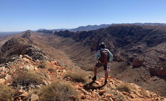
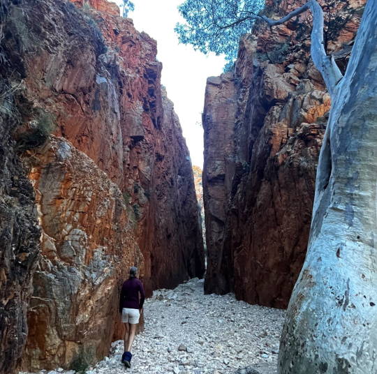
LARAPINTA TRAIL – WHAT IS THE BEST TIME OF YEAR TO WALK?

The Larapinta Trail is located close to the town of Alice Springs on the sacred land of the Arrernte people, stretching across the West MacDonnell Ranges. The Larapinta trek, covering a distance of 223 km, is dotted with sacred indigenous sites and is home to native flora, fauna, high red rock ridgelines, gorges and spectacular views. Most travellers choose to complete the walk over seven days. However, shorter treks are available depending on the difficulty level and experience you seek.
The trail, often referred to as one of Australia’s top hiking treks, is full of wonders and magnificent experiences that give those that walk along it the chance to appreciate its beauty and uniqueness.
The Larapinta Trek takes you through the Ormiston and Serpentine Gorges and offers an opportunity to see Mount Sonder at sunrise. Hikers will be amazed by the dramatic colour changes in the rock formations at Glen Helen Gorge and Standley Chasm. This trek, which is of moderate difficulty, is one of the most spectacular outback experiences in Australia. The trek is an experience of splendid isolation and remoteness of the most spectacular parts of the Larapinta Trail.
Best weather conditions for walking the Larapinta Trail
The months of April to September are widely considered the best time of year to walk the Larapinta Trail. We have detailed below the estimated temperatures that can be expected in each season to help you prepare for your journey.
Autumn (March-May): Temperatures can vary from 8°C to 32°C. These months often have warm days and cooler evenings.
Winter (June-August): Temperatures range from a low of 4°C to a high of 22°C, with the possibility of sub-zero temperatures at night.
Spring (September-November): Temperatures can range from 10°C to 33°C, cooling during the evening.
Summer (December-February): Walking along the Larapinta Trail during this time is not recommended. Temperatures range from 20°C to 36°C, and can reach above 40°C, exposing hikers to many heat-related health risks.
The quiet period of the year
Throughout your trek on the Larapinta Trail, no matter what time of year you visit, you will rarely cross paths with other hikers. The trail covers a large distance, creating space between yourself and other groups. In addition, this track requires training before you start and may only be ideal for some hikers, making this location quieter than other less strenuous trails. In addition, this track requires training before you start, which automatically excludes some trekkers, making this location quieter than other less strenuous trails.
The best time for swimming
Those who have had the pleasure of walking the Larapinta Trail will surely tell you the joy of finding those beautiful waterholes and rivers that line the way. After a long day of walking, soaking in fresh running water can refresh and rejuvenate you.
For those walking on the trail during the warmer autumn months, you may find that the water has a pleasant temperature and is refreshing than if you were walking through the winter months. Central Australia is well known for its warm weather throughout the year but hikers will likely have many opportunities throughout the year for experiencing cooler temperatures along the trek.
As the Larapinta Trail is a sacred site, you are not allowed to swim in certain areas. We recommend checking with your guides for where you can and cannot swim, discovering the safest swimming locations, practising safe behaviour in and around water, and always swimming with a friend.
Walk the Larapinta Trail with Auswalk
A walk of this calibre requires expert guidance to ensure you receive the most outstanding experience possible while exploring the Larapinta Trek. Auswalk has been a pioneer in walking holidays across Australia, including guided, self-guided and custom treks. When you choose us as your travel companion, we organise everything from accommodation to food and leave you to enjoy the journey.
By selecting our guided tour, hikers will be accompanied by two qualified guides who will lead the way with their in-depth knowledge of the trail and its history, safety training and years of experience. Our trips are more than getting you to your destination; it is about cherishing the path that takes you there.
Explore our Larapinta Trail and the many other spectacular Australian walking holiday destinations and see these hidden gems for yourself!
1 note
·
View note
Text
THE THREE CAPES TRACK – AN ULTIMATE GUIDE TO HIKING
The Three Capes Track Overview
Tasmania is a treasure trove for avid hikers looking to immerse themselves in the natural landscape of this Australian island state. The Three Capes Track, covering a staggering 48 kilometres, is one of the few paths on earth that has retained its remote and untouched magnetism.
Located in the southeast of the Tasman National Park, the pathway weaves in and out of dense forest and heathland and introduces travellers to remarkable rainforests and astonishing cliffside views of the Three Capes: Cape Pillar, Cape Hauy and Cape Raoul.

The multi-day track spans many different forms of terrain, from the boardwalk to stone steps, with accommodations in three picturesque locations to make this journey feel more luxurious than your average hike. The one-way walk offers self-guided or guided options and a restriction on the number of hikers permitted on the Three Capes Track per day to give travellers a more intimate experience of the area.
How to reach the start of the Three Capes Track
Port Arthur Historic Site marks the starting and end point of the track. You will begin the Three Capes Track by taking a two-hour boat cruise from the Port Arthur jetty to Denmans Cove and end with a 30-minute bus ride back to Port Arthur from Fortescue Bay.
Here are the travel options available for travellers to get you to and from the Three Capes Track.
The closest airport to Port Arthur is Hobart International Airport. By car, this point is approximately eight kilometres.
Travelling to Port Arthur by car from the following location varies in duration: Hobart to Port Arthur is approximately 1.5 hours, and Launceston to Port Arthur is about 3.5 hours.
If you are unable to drive, there are alternative arrangements you can make with coach services or a taxi/Uber service. We recommend researching local bus routes leaving your arrival and destination and expected costs.
Booking your hike on the Three Capes Track includes a daily bus transfer from Fortescue Bay to Port Arthur Historic Site.
What you can expect on the Three Capes Track
Tasmania is often referred to as the ‘gateway’ to Antarctica, which means the chances of the weather being a little cooler than the mainland is almost guaranteed. For this reason, it is important to pack warm, waterproof clothing for unexpected weather changes. Other hiking essentials include water, food, sturdy hiking boots, toiletries, clothing, sleeping supplies, and a phone charger. It is worth noting that supplies are dependent on your chosen accommodations because many of the lodges/huts provide only some essentials during your stay.
In addition, it is wise to condense your belongings to prevent fatigue from carrying your backpack for around four hours daily over four days. Although this track is considered moderate in terms of difficulty, it does require endurance. Be prepared for long days of walking, take lots of breaks, and enjoy the scenery.

What is included in your pass
Booking your pass to travel along the Three Capes Track will include the following:
Park entry to the Tasman National Park and an Official Pass for the trail
Two years valid entry to Port Arthur Historic Site, and parking and secure locker storage during your trip
A seat on the Pennicott Wilderness Journeys cruise, which departs twice daily
Three nights’ accommodations in huts along the track (self-catered)
Bus transport from the end of the track (Fortescue Bay) to the beginning (Port Arthur Historic Site), which departs twice daily
Travellers also receive a guidebook and a map
There are also guided options through private tour companies, which cost more than a self-guided journey, but provide travellers with an all-inclusive private accommodations.
Three Capes Huts
For those that have chosen the self-guided travel option, three different cabins will be your accommodations throughout your trip. These spaces have shared dorms, kitchen areas, and bathroom facilities. The huts are well-maintained and equipped with a range of amenities. A host ranger will greet hikers as they arrive, provide information about the hut and area, and remain overnight. If you are looking for a Three Capes track self-guided walking company, Auswalk provide an excellent option with a long history in this market.
Day One – The Surveyors Hut
The first stay on your journey is at the Surveyors Hut. The accommodations offer ocean views from the expansive deck, communal sleeping and kitchen areas, and an outdoor barbeque area. The hut is large enough to give travellers space among other guests.
Day Two – The Munro Hut
The second stay on your journey is at the Munro Hut. The accommodations are separated into two buildings, the kitchen and sleeping quarters. As you arrive, you will notice the sweeping views of the ocean from the deck and helipad, and this is the only stay with a hot outdoor shower.
Day Three – The Retakunna Hut
The third stay on your journey is at the Retakunna Hut. This stay is separated into two buildings, the indoor and outdoor kitchen and sleeping lodgings, and the toilet that is a short distance from the hut. This hut is hidden among the gum trees, offering a glimpse of the native residents.
Amenities
Facilities and supplies you can expect during your stay (though they may not be available across all three cabins) include:
Indoor and outdoor kitchens, with cooktops and a range of cooking equipment (excluding fridges and microwaves)
Cooking utensils (excluding cutlery, plates/bowls, and cups)
Rainwater
USB charging ports
Heating and lighting in the shared area
Toilet facilities
Memory foam mattresses in the dorms
Outdoor shower (Munro Cabin only)
Explore the Tasman Coast and witness the magnitude of the landscape surrounding you along the Three Capes Track. Each day offers travellers a glimpse into the beauty that exists in the form of a coastline, the flora of a rainforest, and the songs of the animals and birds that call this place home.
When travelling to this beautiful island state, set aside four days and explore one of the world’s most remarkable natural pathways.
FAQs
How to Book the Three Capes Track
Visit the National Parks website to book to walk the Three Capes Track. During the booking process, you must provide your start date, number of hikers, and pay through credit cards—Mastercard or Visa. A confirmation email with your booking details and a brochure for the track will arrive shortly after. If you are looking for private tours, please note that these can be found on independent websites. Whether self-guided or group-guided tours is the preference, we would recommend Auswalk for this tour.
How Much Does the Three Capes Track Cost?
The cost of the Three Cape Track depends on whether you have selected a self-guided or guided tour. The fee for the former for an adult is $495, at concession is $396, and for a child $396 (including the Tasman National Park pass). Guided tours through private companies can range from upwards of $1,000, depending on your chosen duration and provider.
Can You Hike the Three Capes Track for Free?
Although there isn’t an option to walk the entire track for free, there is a ‘Free Capes Track’, which will lead you to two out of the three capes. Remember that the Tasman National Park pass will still need to be purchased for entry into the park.
This route will start and end in Fortescue Bay and require two to three days to complete, with hikers needing to provide their own accommodations (such as tents, swags, etc.).
How Hard is the Three Capes Walking Track?
This track is graded ‘easy to moderate’ in difficulty level but requires endurance as each day has an average of four hours of walking and a total distance of approximately 48 kilometres to cover. We advise making stops along the way to conserve energy and ensure you feel physically prepared before booking your pass
1 note
·
View note
Text
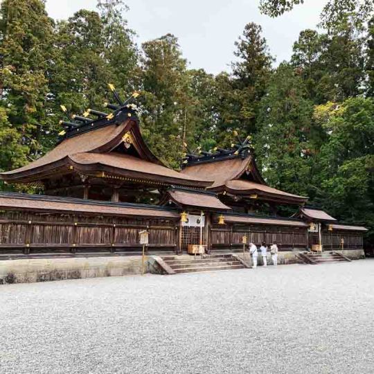
THE KUMANO KODO TRAIL – AN ANCIENT JAPANESE PILGRIMAGE
One of our favourite walks, Explore Kumano Kodo, a UNESCO World Heritage Site, tucked into the mountainous Kii Peninsula and discover Japan’s rich history
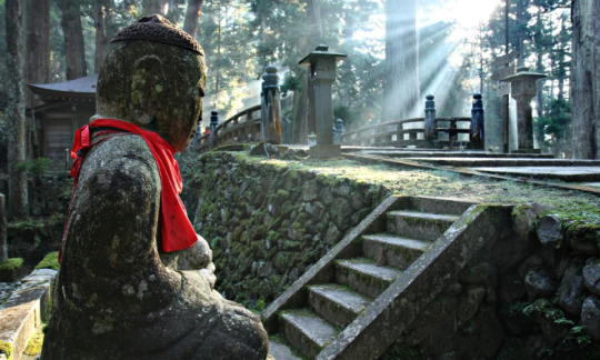
What is the Kumano Kodo?
In the mountains of the Kii Peninsula is an area known as Kumano, where an ancient network of pilgrimage routes to the Kumano Sanzan shrines of Kumano Hongu Taisha, Kumano Hayatama Taisha, and Kumano Nachi Taisha are etched into the earth. Five prominent pilgrimages form the Kumano Kodo:
The Nakahechi Route
The Kohechi Route
The Ohechi Route
The Omine-Okugakemichi Route
The Iseji Route
These pathways offer travellers an authentic experience of Japan as the locals welcome walkers into the region that showcases the island nation’s cultural roots. As you walk across the landscape, you will pass through small Japanese towns, beneath cedar trees, and across paths that follow the shoreline. Each pilgrimage is quite different from the others; some present more challenges, some are longer, and some have rare sights that can only be explored on foot.
History of the Kumano Kodo Pilgrimage Route
The route is considered to be one of the country’s most sacred trails.
During Japan’s formative years, the native religion of Shinto was formed, a way of life that worshipped the natural world and the sacred sites of Kumano. As Buddhism was introduced to Japan, the mountainous area became a training area for Buddhist monks. Eventually, Shintoism and Buddhism merged, creating a syncretic belief system. Over time, the Shinto deities were believed to be emanations of Buddha, and the monasteries became a place of worship.

For over a millennium, the routes became a pathway for those travelling to the Kumano shrines in search of spiritual enlightenment. These trails were crossed by emperors, the nobility and their families, and in later years by samurai warriors and then the people of Japan.
Seven things to expect on the Kumano Kodo
These sacred pathways are rich in history, with each route offering something different. If you have chosen to embark on the Kumano Kodo trail, here are a few things you can expect along the way:
The Kumano Kodo trail is open year-round, but there are ideal times to visit if you want to ensure the best hiking experience. We recommend you hike between April and November for the great weather this area enjoys.
Accommodation is available for hikers along the trail, from lodges to ryokans and minshukus. You must book accommodations before your arrival.
Being fluent in Japanese is appreciated but optional. Most directions and information about the trail are displayed in Japanese and English for international travellers.
Most of the accommodations along the trail have Wi-Fi access for guests.
You can access luggage shuttle services that will transport your belongings from your last accommodations stop to your next. These services are available when you are booking your Kumano Kodo trail, especially through an established service provider like Auswalk.
You have the option to hike the trail independently, guided or self-guided.
The guesthouses and ryokans that hikers stay at along the trail can provide meals during your walk, from dinners to packed lunches, as you make your way to the next town.

Essential Supplies for Kumano Kodo
If you are an avid hiker, you will know that there are essentials to every great hike to make the journey as comfortable and enjoyable as possible. Before walking on the Japanese mountainside, it is important to research and seek out information about supplies that locals and seasoned hikers suggest for this area.
Our research suggests a few essential items you won’t want to forget. Firstly, quality hiking boots. The terrain and duration along the trail can vary, and sturdy and supportive boots can make all the difference. We suggest wearing your boots before you leave to avoid any initial discomfort with new shoes.
Another valuable item is hiking poles. It can be challenging to climb up and down uneven paths, and the added stability will support you as you climb. Many hiking poles have a lightweight, compact design; therefore, they can fold down and be stored in your backpack in between use.
Next, invest in a good-quality backpack that is weather resistant, versatile, and includes a hydro pack for water. It is also essential to fill your backpack with a few bare necessities. A few practical items all hikers should carry include a first aid kit, weatherproof clothing, food, water, a flashlight, and a whistle. Other essentials may be toiletries, a camera, chargers, and clothing.
For those fortunate enough to walk the paths of the Kumano Kodo, take a moment to imagine the lives of those whose footsteps are etched into the earth in the same way yours will be when you leave this sacred place.

Is the Kumano Kodo like the Camino de Santiago?
Only two pilgrimage routes in the world are recognised as UNESCO World Heritage Sites—Kumano Kodo and Camino de Santiago.
There are a few differences, including distance. The Camino de Santiago covers 790 km, while the Kumano Kodo covers 68 km. The conditions are also very different, with the Kumano Kodo weaving through rugged mountain terrain and the Camino de Santiago predominantly winding through rural Spain ( and parts of Portugal and even France).
Is Kumano Kodo crowded?
The Kumano Kodo walk is a relatively quiet journey, with hikers occasionally crossing paths. Due to the limited trail accommodations, travellers can avoid large crowds.
Can you walk the Kumano Kodo trek solo?
Yes, hikers can trek Kumano Kodo by themselves. Booking accommodations at the lodges along the trail ensures that staff in the area are aware of your movements and can account for you at every stop. If you are looking for recommendations for walking companies for the Kumano Kodo trail we suggest Auswalk.
Is the Kumano Kodo a hard hike?
The Kumano Kodo hike offers many different paths, each of which is moderate to challenging. However, these trails vary in difficulty depending on the individual, so thoroughly research each before embarking.

#trails#nature#photography#positivity#tours#groupguided#selfguided#kumano#kumano kodo#japan#japan destinations#japanese culture#japan trip#walking tour
1 note
·
View note
Text
0 notes
Text

Auswalk is Australia's Most Experienced and Trusted Walking Company. We had been operating for nearly 30 years so you’re in safe hands. We are the trusted experts allowing you to walk any time of year, with who you want and in just about any destination you choose. Try our various guides that are avaible for you to enjoy your walk. https://auswalk.com.au/
0 notes
Text
Unleash Your Inner Explorer: Hike the Iconic Larapinta Trail
Auswalk Walking Holidays offers an unforgettable adventure on the iconic Larapinta Trail. Explore the rugged terrain and diverse landscape while immersing yourself in the cultural history of the traditional landowners, the Arrernte people. With experienced guides and comfortable accommodations, Auswalk Walking Holidays is the perfect way to experience the challenge and beauty of this must-see destination. Visit our website https://auswalk.com.au/
0 notes