#for friend's blocklist ur welcome also keep liveblogging it to me
Text
of Tangled and Corona and fictional maps
lads i just got up with pure spite bc my morning eyes fell into this post and to yet another “official” map and I want to talk about this. Listen. A couple of friends and I are going semi-feral over maps plastered in tts so it’s time to share that small collection and also yell. Presented below
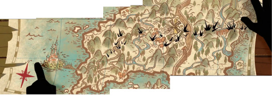
1. Strategy room map

(ignore the fact the screencap is from rapunzeltopia. It doesn’t matter, only the rock placement is different and also nonexistent in the real map. I couldn’t bother my ass to go find a pic of the real map from s1 bc Fred always stands on the way and it doesn’t matter)
Immediate notes: Corona is positioned on a peninsula. There’s no way to tell the scale of the map but it appears to be rough topography map (argument point: mountains are drawn and not showed like they usually would but I’m a bitch and will ignore than in favour of ranting about that weird worm formation on north). (Seriously what’s up with that weird formation what could it be)
North of the country appears to be quite flat and near the ocean level while south of the country is higher ground (this at least pairs up with the “official” map which i will talk about later).
Wall... sure exists, but its placement in relation to sunflower spot and corona main city baffles me.
Sea monster status: hiding behind too fancy north arrow
2. Varian’s map
(screencapped and very fervently edited in ms paint by your’s truly. It’s missing some bits and pieces but also I’m not redoing it)
Immediate notes: starts the long line of “Varian appearing with some funky perspective map please learn to draw them like a sane person would” nightmare maps, yet somehow still the most accurate description of the country.
The peninsula shape is WILDY different from the strategy room map and they each have different river and lake formations. Peninsula here appears a lot smaller and shorter, and while we see some resemblance for scaling in the border, there’s no explanation for it still. Waterfall visible in some other maps is further south here and whole country seems to be more or less mountain/hill area.
Corona might have some map tradition of drawing maps only relevant for certain areas (Old Corona has given lots of detail here down to the field placements compared to other villages or to the capital which leads me to think other places might do the same). By style it tries to emulate old timey maps which is fine, bc they were all more or less mind maps.
Wall: has towers now
Sea monster status: it apparently exists but I cut it out (friend pointed out)
3. Movie map and book map

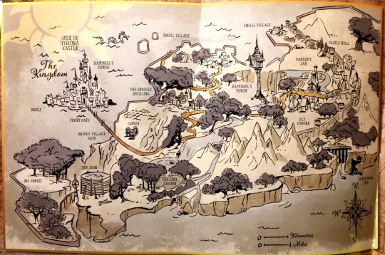
(Book map pic credit at the link at the very start of this hellshow of a post) I’m putting these two together bc from the bunch, they resemble each others the most (and are also only maps not shown in the series). Movie credit map seems to be almost identical for book map, just zoomed in.
Immediate notes: this is? drawn by Eugene? (I said and rewatched s2e3 which revealed man can’t draw shit but still) We have a scale now but un-fUCKING-FORTUNATELY it tells us shit. We can always assume that 0 ---- Kilometres means ---- is 1km, but there’s really no way telling that and thus I sadly have to ignore it. It’s also a mind map yet again, does corona...... does corona have any real geographers? no?
Capital placement differs from show maps and so does the peninsula shape, again. Unlike previous maps where landmass kept growing north, here it caps off, indicating even longer peninsula Corona is only a part of. South part of the country appears to be high cliffs while north part has fields and villages, which pairs with strategy room topography map, but could also just be weird perspective. Nothing’s so far explaining the worm formation.
Waterfall I pointed out in previous map actually factoid error, it is here in the same mountain area too. The out-of-the-country bridge is further south compared to varian’s map, but Old corona has still weirdly got lots of focus (ya telling me this bitch ass country got only two bigger towns??). Movie&book map has other, mostly movie related details not relevant and thus not visible in show maps, which saddens me a bit bc hey........ maps.... should be equal..... show us the dam in other maps too you cowards...
Wall: doesnt run from sea to sea, has towers
Sea monster status: definitely there
4. Spire map
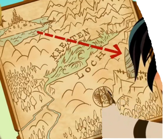
Lord forgive me from ever trying to screencap this monster. Whoever did this should be both publicly shamed and fired from making any more maps, I have no words. Friend yelled in chat when I showed this. It’s a spawn of satan and not in a wholesome blue exorcist way.
Immediate notes: Burn it. There’s no north arrow, but based on Capital’s position north is either up or up-left corner (depending on which maps we go by). Neither of those position saves this map from the fact that thERE IS NO LANDMASS IN SOUTH OF CORONA THAT COULD FIT ALL OF THIS. IT’S A PENINSULA. THE WHOLE TIP OF PENINSULA IS CORONA. FUCK OFF-
Wall: Schrödinger's wall at this point
Sea monster status: finally defeated, like my sanity
5. Strategy map vol2

for some reason they had time to place down individual trees yet there’s no fields and also the river is all wrong when compared to reality.
Immediate notes: a clear example of really zoomed in map, the whole portion of the country between capital and old corona is skipped and that’s fine. North arrow comparable with previous show maps but not with movie&book map so it feels like they exist in entirely different universe where whole continent is slightly sifted to north-east.
I’d want to believe this maps gives more accurate reading to Old corona than Varian’s map, giving it’s nature, but it also does.... have the river all wrong and it drives me so mad.
Wall: is there
Sea monster status: left
- Bonus map for the geologists *blows kiss*

I am so sorry but they just bullshitted that particular group project there is no way, listen. I appreciate the effort clearly done here in cataloguing rock placements in what appears to be Old corona but a) they are facing south (Capital is always to the west and can be seen in the bg here) and you’re making pure assumptions based on how they are behaving on the very edges of your east border there and b) thAT PARTICULAR PIECE OF PAPER, LISTEN, that particular piece of paper is positioned smack under Old corona and it’s tunnel system yet you nuckleheads somehow think it’s comparable for the island’s tunnel system oN THE OTHER SIDE OF YOUR COUNTRY CAN YOU EVER STOP TO THINK-
--
I do have the map of s2 places but given how shitass of a map it is I chose not to include it here. It makes me so angry. Not quite as angry as the Spire map but it’s up there and I do not want to think about it. Also I don’t think it was even meant to be accurate or show any real continents so looking at it would give u nothing.
#tangled the series#tts#rta#omat paskat#I will keep you posted on new map discoveries but seeing how we're in s2 I'm not holding my breath#tangled#for friend's blocklist ur welcome also keep liveblogging it to me#i know you wont see that tag but still i enjoy it
47 notes
·
View notes
Last Seen Blogs

that-soccer-guru
I'm just out here loving Soccer ✌🏻

ultrar
❀ ⠀ ꫶ࣺ᭮᭰

hestiism-blog
HestiIsm

vendingmachinep0rn
Vending Machine P*RN

thethriftaesthestic
The Thrift Aesthestic